14 December 2016
NOTICE OF
ORDINARY COUNCIL MEETING
Your attendance
is respectfully requested at the Ordinary Meeting of Cabonne Council convened
for Tuesday 20 December, 2016 commencing at 2.00pm,
at the Cabonne Council Chambers, Bank Street, Molong to consider the
undermentioned business.
Yours faithfully

Stephen J Harding
ACTING GENERAL MANAGER
ORDER OF
BUSINESS
1) Open
Ordinary Meeting
2) Consideration
of Mayoral Minute
3) Consideration
of Acting General Manager’s Report
4) Resolve
into Committee of the Whole
a) Consideration of
Called Items
b) Consideration of
Closed Items
5) Adoption of Committee of the Whole Report
ATTENDEES – DECEMBER 2016 COUNCIL
MEETING
|
2.00pm
|
Audrey Meehan – Daroo Award
Winner Recognition
|
|
|
|
|
|
|
|
|
|
|
|
|
GENERAL MANAGER’S REPORT ON MATTERS FOR
DETERMINATION SUBMITTED TO THE Ordinary Council Meeting TO BE HELD ON Tuesday 20 December, 2016
Page 1
TABLE OF
CONTENTS
ITEM 1 APPLICATIONS FOR LEAVE OF ABSENCE.................................. 3
ITEM 2 DECLARATIONS OF INTEREST....................................................... 3
ITEM 3 DECLARATIONS FOR POLITICAL DONATIONS.......................... 3
ITEM 4 MAYORAL MINUTE - APPOINTMENTS........................................... 3
ITEM 5 COMMITTEE OF THE WHOLE........................................................... 3
ITEM 6 GROUPING OF REPORT ADOPTION.............................................. 3
ITEM 7 CONFIRMATION OF THE MINUTES................................................. 3
ITEM 8 AUSTRALIA DAY AWARDS COMMITTEE MEETING................... 3
ITEM 9 VILLAGE ENHANCEMENT RESERVE............................................. 3
ITEM 10 ITEM 4 CONFIDENTIAL - 22 NOVEMBER 2016
ORDINARY COUNCIL MEETING................................................................................................................... 3
ITEM 11 2016 NATIONAL LOCAL ROADS AND TRANSPORT
CONGRESS 3
ITEM 12 NOVEMBER 2016 LOCAL TRAFFIC COMMITTEE....................... 3
ITEM 13 DECEMBER 2016 LOCAL TRAFFIC COMMITTEE........................ 3
ITEM 14 COUNCIL'S POLICY REGISTER - AMENDMENT OF
"Hire of Items - Molong Cudal Community Centres and s355 Operated Halls
Policy" 3
ITEM 15 ORANA HOUSE (LOT 126 DP 1105484 FERGUSON
STREET, CANOWINDRA), FORMER COURT HOUSE (LOT 321 DP 820931 GASKILL STREET,
CANOWINDRA AND 70 GASKILL STREET, CANOWINDRA (LOT 1 DP 108962)................................................................................................................... 3
ITEM 16 LOCAL GOVERNMENT REMUNERATION TRIBUNAL -
REVIEW FOR THE 2017 ANNUAL DETERMINATION................................................................ 3
ITEM 17 REQUESTS FOR DONATIONS.......................................................... 3
ITEM 18 HIDDEN TREASURES HONOUR ROLL 2016................................. 3
ITEM 19 ADDITIONAL BACKLOG PROJECTS FOR 2016/2017................ 3
ITEM 20 PURCHASE OF OUTREACH MOWER ATTACHMENTS............. 3
ITEM 21 DEVELOPMENT APPLICATION 2017/0055 FOR FARM
STAY ACCOMMODATION UPON LOT 100 DP 1122908 BEING 299 NANCARROW LANE, NASHDALE............................................................................... 3
ITEM 22 DEVELOPMENT APPLICATION 2017/0012 TWO LOT
SUBDIVISION (BOUNDARY ADJUSTMENT), LOT 263 DP 750162 AND LOT 1 DP 1114093,
ORANGE ROAD, MANILDRA............................................................. 3
ITEM 23 DEVELOPMENT APPLICATION 2016/0128 FOR PROPOSED
OPEN CUT MINE (LIMESTONE MINE) AND ANCILLARY PROCESSING - PROPOSED LOTS 100
& 101 IN SUBDIVISION OF LOT 2 DP 590034, LOT 136 DP 664861 AND LOT 137 DP
652082, BEING LAND KNOWN AS 115 CANOMODINE LANE, CANOWINDRA.................................................................................................................... 3
ITEM 24 DEVELOPMENT APPLICATION 2017/0031 FOUR LOT
RURAL SUBDIVISION OF LOTS 35 & 47 DP 750389 AND LOTS 102 & 103 IN DP
1005154, 521 GOWAN ROAD, GOWAN..................................................................................... 3
ITEM 25 PLANNING PROPOSAL - REZONING OF FORMER CWA
HALL, HILL STREET, MOLONG AND INCLUSION OF RURAL BOUNDARY ADJUSTMENT CLAUSE TO
CABONNE LEP 2012............................................................................ 3
ITEM 26 PLANNING PROPOSAL PREPARED BY ORANGE CITY
COUNCIL TO AMEND ORANGE LOCAL ENVIRONMENTAL PLAN 2011 - AIRPORT ESTATE AT
SPRING HILL.......................................................................................... 3
ITEM 27 DRAFT CONTAMINATED LAND POLICY....................................... 3
ITEM 28 QUESTIONS FOR NEXT MEETING................................................... 3
ITEM 29 BUSINESS PAPER ITEMS FOR NOTING........................................ 3
ITEM 30 MATTERS OF URGENCY.................................................................... 3
ITEM 31 COMMITTEE OF THE WHOLE SECTION OF THE MEETING..... 3
Confidential Items
Clause 240(4) of the Local
Government (General) Regulation 2005 requires Council to refer any business to
be considered when the meeting is closed to the public in the Ordinary Business
Paper prepared for the same meeting. Council will discuss the following
items under the terms of the Local Government Act 1993 Section 10A(2), as
follows:
ITEM 1 CARRYING OF COUNCIL RESOLUTION INTO CLOSED
COMMITTEE OF THE WHOLE MEETING
Procedural
ITEM 2 ENDORSEMENT OF PROCEEDINGS OF CONFIDENTIAL
MATTERS CONSIDERED AT COMMITTEE OF THE WHOLE MEETING
Procedural
ITEM 3 DEBT RECOVERY REPORT OF OUTSTANDING DEBTS
(b) matters in relation to the
personal hardship of a resident or ratepayer
ITEM 4 WATER ACCOUNT 4228000008 REQUEST FOR
CONSIDERATION OF COSTS
(b) matters in relation to the
personal hardship of a resident or ratepayer
ITEM 5 WATER ACCOUNT 4227000009 REQUEST FOR
CONSIDERATION OF COSTS
(b) matters in relation to the
personal hardship of a resident or ratepayer
ITEM 6 CANOWINDRA RETIREMENT VILLAGE
(c) information that would, if
disclosed, confer a commercial advantage on a person with whom the Council is
conducting (or proposes to conduct) business
ITEM 7 MOLONG LIMESTONE QUARRY
(c) information that would, if
disclosed, confer a commercial advantage on a person with whom the Council is
conducting (or proposes to conduct) business
ITEM 8 CANOWINDRA CARAVAN PARK MANAGEMENT
(c) information that would, if
disclosed, confer a commercial advantage on a person with whom the Council is
conducting (or proposes to conduct) business
ANNEXURE ITEMS
ANNEXURE 7.1 November 22 2016 Ordinary Council Minutes. 3
ANNEXURE 8.1 November 22 2016 Australia Day Awards
Committee Minutes 3
ANNEXURE 12.1 November 24 2016 Traffic Committee Minutes 3
ANNEXURE 13.1 December Traffic Committee Minutes .............. 3
ANNEXURE 15.1 Councillor Workshop Minutes 8 November 2016 3
ANNEXURE 17.1 CWA Request for Sponsorship for 2017 Public
Speaking Competition......................................................................... 3
ANNEXURE 20.1 Outreach Mower............................................................. 3
ANNEXURE 23.1 Notice of Consent.......................................................... 3
ANNEXURE 23.2 Westlime Pty Ltd document to support ......... 3
ANNEXURE 24.1 Conditions of Consent................................................ 3
ANNEXURE 27.1 Draft Contaminated Land Policy - Contamination
Central Dec 2016.................................................................................. 3
ITEM
1 - APPLICATIONS FOR LEAVE OF ABSENCE
REPORT IN
BRIEF
|
Reason For Report
|
To allow tendering of apologies
for Councillors not present.
|
|
Policy Implications
|
Nil
|
|
Budget Implications
|
Nil
|
|
IPR Linkage
|
4.5.1.g - Code of Meeting
Practice adopted and implemented.
|
|
Annexures
|
Nil
|
|
File Number
|
\OFFICIAL RECORDS
LIBRARY\GOVERNANCE\COUNCIL MEETINGS\COUNCIL - COUNCILLORS LEAVE OF ABSENCE -
796341
|
|
Recommendation
THAT any apologies tendered be
accepted and the necessary leave of absence be granted.
|
Acting General Manager's REPORT
A call for apologies is to be
made.
Please note that guidelines have
been issued under Section 23A of the Local Government Act titled “Council
decision making during merger proposal periods”. Council must consider
the guidelines in relation to each decision they make during the proposal
period, this matter is of an ongoing nature and it is considered it complies
with the guidelines.
ITEM
2 - DECLARATIONS OF INTEREST
REPORT IN
BRIEF
|
Reason For Report
|
To allow an opportunity for
Councillors to declare an interest in any items to be determined at this
meeting.
|
|
Policy Implications
|
Nil
|
|
Budget Implications
|
Nil
|
|
IPR Linkage
|
4.5.1.g - Code of Meeting
Practice adopted and implemented.
|
|
Annexures
|
Nil
|
|
File Number
|
\OFFICIAL RECORDS
LIBRARY\GOVERNANCE\COUNCIL MEETINGS\COUNCIL - COUNCILLORS AND STAFF
DECLARATION OF INTEREST - 2016 - 796342
|
|
Recommendation
THAT the Declarations of
Interest be noted.
|
Acting General Manager's REPORT
A call for Declarations of
Interest.
Please note that guidelines have
been issued under Section 23A of the Local Government Act titled “Council
decision making during merger proposal periods”. Council must consider
the guidelines in relation to each decision they make during the proposal
period, this matter is of an ongoing nature and it is considered it complies
with the guidelines.
ITEM
3 - DECLARATIONS FOR POLITICAL DONATIONS
REPORT IN
BRIEF
|
Reason For Report
|
To allow an opportunity for
Councillors to declare any Political Donations received.
|
|
Policy Implications
|
Nil
|
|
Budget Implications
|
Nil
|
|
IPR Linkage
|
4.5.1.g - Code of Meeting
Practice adopted and implemented.
|
|
Annexures
|
Nil
|
|
File Number
|
\OFFICIAL RECORDS
LIBRARY\GOVERNANCE\COUNCIL MEETINGS\COUNCIL - COUNCILLORS DECLARATION OF
POLITICAL DONATIONS - 796344
|
|
Recommendation
THAT any Political Donations be
noted.
|
Acting General Manager's REPORT
A call for declarations of any
Political Donations.
Please note that guidelines have
been issued under Section 23A of the Local Government Act titled “Council
decision making during merger proposal periods”. Council must consider
the guidelines in relation to each decision they make during the proposal
period, this matter is of an ongoing nature and it is considered it complies
with the guidelines.
ITEM
4 - MAYORAL MINUTE - APPOINTMENTS
REPORT IN
BRIEF
|
Reason For Report
|
To allow noting of the Mayoral
appointments plus other Councillors' activities Reports.
|
|
Policy Implications
|
Nil
|
|
Budget Implications
|
Nil
|
|
IPR Linkage
|
4.5.1.g - Code of Meeting
Practice adopted and implemented.
|
|
Annexures
|
Nil
|
|
File Number
|
\OFFICIAL RECORDS
LIBRARY\GOVERNANCE\COUNCIL MEETINGS\MAYORAL MINUTES - 796345
|
|
Recommendation
THAT the information contained
in the Mayoral Minute be noted.
|
Acting General Manager's REPORT
A call for the Mayoral
appointments and attendances as well as other Councillors’ activities
reports to be tabled/read out.
Please note that guidelines have
been issued under Section 23A of the Local Government Act titled “Council
decision making during merger proposal periods”. Council must consider
the guidelines in relation to each decision they make during the proposal
period, this matter is of an ongoing nature and it is considered it complies
with the guidelines.
ITEM 5 - COMMITTEE OF THE
WHOLE
REPORT IN BRIEF
|
Reason For Report
|
Enabling
reports to be considered in Committee of the Whole to be called.
|
|
Policy Implications
|
Nil
|
|
Budget Implications
|
Nil
|
|
IPR Linkage
|
4.5.1.g. Code of Meeting
Practice adhered to
|
|
Annexures
|
Nil
|
|
File Number
|
\OFFICIAL
RECORDS LIBRARY\GOVERNANCE\COUNCIL MEETINGS\GROUPING OF REPORT ADOPTION and
BUSINESS PAPER ITEMS FOR NOTING REPORTS - 796346
|
|
Recommendation
THAT
Councillors call any items that they wish to be debated in Committee of the
Whole.
|
Acting General Manager's REPORT
Council’s Code of Meeting
Practice allows for the Council to resolve itself into “committee of the
whole” to avoid the necessity of limiting the number and duration of
speeches as required by Clause 250 of the Local Government (General) Regulation
2005.
This item enables councillors to
call any item they wish to be debated in “committee of the whole”
at the conclusion of normal business.
The debate process during a
‘normal’ Council meeting limits the number and duration of speeches
as required by Clause 250 of the Local Government (General) Regulation
2005.
Items should only be called at
this time if it is expected that discussion beyond the normal debate process is
likely to be needed.
Please note that guidelines have
been issued under Section 23A of the Local Government Act titled “Council
decision making during merger proposal periods”. Council must consider
the guidelines in relation to each decision they make during the proposal
period, this matter is of an ongoing nature and it is considered it complies
with the guidelines.
ITEM
6 - GROUPING OF REPORT ADOPTION
REPORT IN
BRIEF
|
Reason For Report
|
Enabling procedural reports to
be adopted.
|
|
Policy Implications
|
Nil
|
|
Budget Implications
|
Nil
|
|
IPR Linkage
|
4.5.1.a - Provide quality
administrative support and governance to councillors and residents.
|
|
Annexures
|
Nil
|
|
File Number
|
\OFFICIAL RECORDS
LIBRARY\GOVERNANCE\COUNCIL MEETINGS\GROUPING OF REPORT ADOPTION and BUSINESS
PAPER ITEMS FOR NOTING REPORTS - 796347
|
|
Recommendation
THAT:
1. Councillors
call any items they wish to further consider
2. Items
7 to 13 be moved and seconded.
|
Acting General Manager's REPORT
Items 7 to 13 are considered to
be of a procedural nature and it is proposed that they be moved and seconded as
a group. Should any Councillor wish to amend or debate any of these items
they should do so at this stage with the remainder of the items being moved and
seconded.
Please note that guidelines have
been issued under Section 23A of the Local Government Act titled “Council
decision making during merger proposal periods”. Council must consider
the guidelines in relation to each decision they make during the proposal
period, this matter is of an ongoing nature and it is considered it complies
with the guidelines.
ITEM
7 - CONFIRMATION OF THE MINUTES
REPORT IN
BRIEF
|
Reason For Report
|
Adoption of the Minutes
|
|
Policy Implications
|
Nil
|
|
Budget Implications
|
Nil
|
|
IPR Linkage
|
4.5.1.g - Code of Meeting
Practice adopted and implemented.
|
|
Annexures
|
1. November
22 2016 Ordinary Council Minutes⇩
|
|
File Number
|
\OFFICIAL RECORDS
LIBRARY\GOVERNANCE\COUNCIL MEETINGS\COUNCIL - MINUTES - 2016 - 796348
|
|
Recommendation
THAT the minutes of the
Ordinary meeting held 22 November 2016 be adopted.
|
Acting General Manager's REPORT
The following minutes are
attached for endorsement.
1. Minutes of the Ordinary Council meeting held on 22
November 2016;
Please note that guidelines have
been issued under Section 23A of the Local Government Act titled “Council
decision making during merger proposal periods”. Council must consider
the guidelines in relation to each decision they make during the proposal
period, this matter is of an ongoing nature and it is considered it complies
with the guidelines.
ITEM
8 - AUSTRALIA DAY AWARDS COMMITTEE
MEETING
REPORT IN
BRIEF
|
Reason For Report
|
Adoption of Australia Day
Awards Committee Recommendations.
|
|
Policy Implications
|
Nil
|
|
Budget Implications
|
Nil
|
|
IPR Linkage
|
4.5.1.f - Code of Meeting
Practice adopted and implemented.
|
|
Annexures
|
1. November
22 2016 Australia Day Awards Committee Minutes⇩
|
|
File Number
|
\OFFICIAL RECORDS
LIBRARY\RECREATION AND CULTURAL SERVICES\EVENTS MANAGEMENT\AUSTRALIA DAY 2017
- 797296
|
|
Recommendation
THAT the report and
recommendations of the Australia Day Awards Committee Meeting of Cabonne Council
held on 22 November, 2016 be adopted.
|
Administration Manager's REPORT
Attached is the report of the
Australia Day Awards Committee Meeting of Cabonne Council held on 22 November,
2016 for Council’s adoption.
Please note that guidelines have been
issued under Section 23A of the Local Government Act titled “Council
decision making during merger proposal periods”. Council must consider
the guidelines in relation to each decision they make during the proposal
period, this matter is of an ongoing nature and it is considered it complies
with the guidelines.
ITEM 9 - VILLAGE ENHANCEMENT
RESERVE
REPORT IN BRIEF
|
Reason For Report
|
For Council to
resolve to transfer $700,000 from the Plant Reserve to Village Enhancement
Reserve.
|
|
Policy Implications
|
Nil
|
|
Budget Implications
|
Yes -
Transfer of funds between reserves
|
|
IPR Linkage
|
4.5.1.c - Provide appropriate
mechanisms for democracy and participation for Cabonne residents
|
|
Annexures
|
Nil
|
|
File Number
|
\OFFICIAL
RECORDS LIBRARY\FINANCIAL MANAGEMENT\BUDGETING\QBRs - QUARTERLY BUDGET
REVIEWS - 797263
|
|
Recommendation
THAT Council
resolve to transfer $700,000 to the Village Enhancement Reserve from the
Plant Reserve.
|
Acting Director of Finance & Corporate
Services' REPORT
At the councillor workshop held
in Canowindra on Tuesday 6 December 2016 councillors discussed the need for an
additional $700,000 to be transferred from the Plant Reserve to the Village
Enhancement Reserve.
Please note that guidelines have
been issued under Section 23A of the Local Government Act titled “Council
decision making during merger proposal periods”. Council must consider
the guidelines in relation to each decision they make during the proposal period.
The funds that are being transferred are from an internal reserve and at this
stage no details of the proposed expenditure in the Village Enhancement Reserve
have been resolved.
ITEM 10 - ITEM 4 CONFIDENTIAL
- 22 NOVEMBER 2016 ORDINARY COUNCIL MEETING
REPORT IN BRIEF
|
Reason For Report
|
For Council to
approve expenditure as per details in report.
|
|
Policy Implications
|
Nil
|
|
Budget Implications
|
Nil
|
|
IPR Linkage
|
4.5.1.c - Provide appropriate
mechanisms for democracy and participation for Cabonne residents
|
|
Annexures
|
Nil
|
|
File Number
|
\OFFICIAL RECORDS
LIBRARY\FINANCIAL MANAGEMENT\DEBTORS\DEBT RECOVERY - 797271
|
|
Recommendation
THAT:
1. Council approve the write-off of
charges as detailed in the confidential report to Council on 22 November
2016; and
2. Resolve that the expenditure is
required and warranted to enable the matter to be finalised.
|
Acting Director of Finance & Corporate
Services' REPORT
At the November Ordinary Council
meeting in the Confidential paper, the following was resolved: -
”1. Council waive the amount of three months’
rent, being equivalent to $1,320 due to flooding issues;
2. The tenant enter into a payment arrangement agreement
with Council for the balance of the arrears that is suitable to both parties;
3. Should the tenant break this arrangement, Council
take debt recovery action to recover the full amount outstanding and take the
necessary action to evict the tenant from the premises; and
4. A further report be provided to Council.”
Please note that guidelines have
been issued under Section 23A of the Local Government Act titled “Council
decision making during merger proposal periods”. Council must consider
the guidelines in relation to each decision they make during the proposal
period. Under the guidelines funding that was not included in council’s
original budget must be considered in open council and the resolution voting
the funds must state the reason why council considered the expenditure is
required and warranted.
ITEM 11 - 2016 NATIONAL LOCAL
ROADS AND TRANSPORT CONGRESS
REPORT IN BRIEF
|
Reason For Report
|
To inform
Council in a report of the congress.
|
|
Policy Implications
|
Consistent
with Payment of expenses and provision of facilities and Mayors Policy.
|
|
Budget Implications
|
Conferences
and Seminars budget
|
|
IPR Linkage
|
1.4.1.e. Roads to Recovery
federal local roads program undertaken
|
|
Annexures
|
Nil
|
|
File Number
|
\OFFICIAL
RECORDS LIBRARY\GOVERNMENT RELATIONS\LOCAL AND REGIONAL LIAISON\AUSTRALIAN
LOCAL GOVERNMENT ASSOCIATION - 796883
|
|
Recommendation
THAT Council
continue to support the National Local Roads and Transport Congress.
|
Acting Director of Engineering & Technical
Services' REPORT
Council sent two delegates to the annual
National Local Roads and Transport Congress that was held at Toowoomba, Queensland
during 9 – 11 November 2016. The venue for the congress was the Empire
Theatre Toowoomba.
The congress was attended by 181 delegates
from across Australia and its theme was “Local Infrastructure –
Developing Regions”.
The congress was preceded by a welcoming
reception held at the Cobb and Co. Museum, a fitting venue that showcases the
history of road transport from a bygone era.
The congress was opened by the newly
elected Australian Local Government Association (ALGA) President David
O’Loughlin, who stated that the aims at this year’s congress is to
continue work with governments and advocate for funding for local roads and
bridges to meet the needs of local communities across Australia. For local road
networks to thrive, all three levels of government must remain committed to
working collaboratively on transport planning.
The keynote address was given by Martin
Matthews, former Ministry of Transport Chief Executive, New Zealand, who spoke
about innovation and modern technologies that are available and being applied
to transport delivery and distribution.
The remainder of the morning and the first
part of the afternoon session focused on Partnership for Improved
Infrastructure and Regional Road Planning Initiatives. This was a panel
session and was represented by Jeremy Parkinson from Infrastructure Australia,
Sal Petroccitto from National Heavy Vehicle Regulator, Dr Andrew Higgins from
CSIRO and Nicole Spencer from Department of Infrastructure and Transport. The
final session for the day was a workshop titled “How to prepare your
Council to engage in Regional Road Planning.”
The second day commenced with a government
address from The Honorable Darren Chester MP, the Minister for Infrastructure
and Transport, who reinforced the present Federal Government’s support
for the continuance and commitment to the Roads to Recovery Program. He was
followed later in the morning by The Honorable Anthony Albanese MP, the Shadow
Minister for Infrastructure, Transport, Cities and Regional Development. He spoke
about his long term association with Local Government in Australia and his
continued support of the current Federal Government Programs.
The remaining sessions on the day related
to Road Safety Strategies, Towards Zero Program and Data Harmonisation. Local
Governments are being encouraged by Federal and State Governments to employ
strategies to address the impact of catastrophic crashes by means of vehicle
separation and run off road protection.
The congress was a rewarding success for
the delegates that attended and it gave an opportunity to meet and network with
their peers in the Local Government sector and bring back to Council the focus
of the Federal funding providers.
Please note that guidelines have
been issued under Section 23A of the Local Government Act titled “Council
decision making during merger proposal periods”. Council must
consider the guidelines in relation to each decision they make during the
proposal period, this matter is of an ongoing nature and it is considered it
complies with the guidelines.
ITEM 12 - NOVEMBER 2016 LOCAL
TRAFFIC COMMITTEE
REPORT IN BRIEF
|
Reason For Report
|
For Council to
ratify the recommendations of the Local Traffic Committee meeting of November
2016
|
|
Policy Implications
|
Nil
|
|
Budget Implications
|
Nil
|
|
IPR Linkage
|
4.5.1.a. Provide quality
administrative support and governance to councillors and residents
|
|
Annexures
|
1. November
24 2016 Traffic Committee Minutes⇩
|
|
File Number
|
\OFFICIAL
RECORDS LIBRARY\CORPORATE MANAGEMENT\MEETINGS\TRAFFIC COMMITTEES - 797536
|
|
Recommendation
THAT Council
ratify the recommendations of the Local Traffic Committee meeting held 24
November 2016.
|
Acting Technical Services Manager's REPORT
Attached are the minutes of the Local Traffic
Committee meeting held 24 November 2016. The items addressed and their
associated recommendations are as follows:
Item 3. Newcrest Orange Challenge
2017
THAT Council approve the event subject to:
1. Amendment of the Traffic Management Plan to
account for the timing of the event.
2. Implementation of the Risk Management Plan
and Traffic Management Plan, in accordance with the “Guide to Traffic and
Transport Management for Special Events” (RTA, v3.4 August 2006) for a
Class 2 event
3. NSW Road Rules being observed by
participants at all times
4. Written approval being obtained from the
NSW Police Regional Commander under Section 115 of the Roads Transport Act
(2013)
5. Written approval being obtained from all
affected Local Government Authorities
6. Council being provided with an updated copy
of the $20M Public Liability Insurance Policy indicating Cabonne
Council’s interests, with the date and location of the event
7. The event organiser notifying all emergency
services of the event
8. The event organiser debrief Council on the event. This includes
notifying Council of all incidents or near misses that occurred during the
event
Item 4. NSW Masters Road Cycling
Championships
THAT Council
approve the request subject to:
1. Amendment of the
Traffic Management Plan to account for the timing of the event.
2. Implementation of
the Risk Management Plan and Traffic Management Plan, in accordance with the
“Guide to Traffic and Transport Management for Special Events”
(RTA, v3.4 August 2006) for a Class 2 event
3. NSW Road Rules
being observed by participants at all times
4. Written approval
being obtained from the NSW Police Regional Commander under Section 115 of the
Roads Transport Act (2013)
5. Written approval
being obtained from all affected Local Government Authorities
6. Council being
provided with an updated copy of the $20M Public Liability Insurance Policy
indicating Cabonne Council’s interests, with the date and location of the
event
7. The event organiser notifying
all emergency services of the event
8. The event organiser
debrief Council on the event. This includes notifying Council of all incidents
or near misses that occurred during the event
Item 5. Orange Mountain Bike Club
– Change of Dates
THAT Council approve the application
subject to:
1. Implementation of the Risk Management
Plan and Traffic Management Plan, in accordance with the “Guide to
Traffic and Transport Management for Special Events” (RTA, v3.4 August
2006) for a Class 2 event
2. NSW Road Rules being observed by
participants at all times
3. Written approval being obtained from
NSW Police
4. Written approval
being obtained from all affected Local Government Authorities
5. Council being
provided with an updated copy of the $20M Public Liability Insurance Policy
indicating Cabonne Council’s interests, with the date and location of the
event
6. The
event organiser notifying all emergency services of the event
7. The organiser debrief Council on the
event. This includes notifying Council of all incidents or near misses that
occurred during the event
Item 6. Pig Push
THAT Council
approve the application subject to:
1. No reasonable obstruction caused to
vehicular traffic
2. Queues of traffic not exceeding 50m
3. A 4th vehicle placed immediately
behind the participants (Pig)
4. Implementation of the Risk Management
Plan and Traffic Management Plan, in accordance with the “Guide to
Traffic and Transport Management for Special Events” (RTA, v3.4 August
2006) for a Class 2 event
5. NSW Road Rules being observed by
participants at all times
6. Written approval being obtained from
NSW Police
7. Written approval being obtained from
all affected Local Government Authorities
8. Council being provided with an
updated copy of the $20M Public Liability Insurance Policy indicating Cabonne
Council’s interests, with the date and location of the event
9. The event organiser notifying all
emergency services of the event
10. The organiser debrief Council on the event. This
includes notifying Council of all incidents or near misses that occurred during
the event
Item 7. Speed Zone Review for Boree
Lane, McDonald Road and Bowan Park Road
That Council forward the request to RMS
Item 8. Manildra Flour Mill –
Change ‘No Stopping’ sign to ‘Loading Zone’ sign
THAT
more information is received and the matter put forward in an electronic Local
Traffic Committee.
Item 9. Mirror on Nancarrow Lane
THAT the Committee advise Council to
undertake a site investigation to assess road geometry and the necessity for
advanced road signage.
Item 10. Bus Route Extension along
Bowens Lane
THAT Council support the change in route
provided the vehicle follows a clockwise route, turning Right onto Yellowbox
Road from The Escort Way and turning Left onto The Escort Way from Bowens Lane.
Please note that guidelines have been
issued under Section 23A of the Local Government Act titled “Council
decision making during merger proposal periods”. Council must consider
the guidelines in relation to each decision they make during the proposal
period, this matter is of an ongoing nature and it is considered it complies
with the guidelines.
ITEM 13 - DECEMBER 2016 LOCAL
TRAFFIC COMMITTEE
REPORT IN BRIEF
|
Reason For Report
|
For Council to
ratify the recommendations of the Local Traffic Committee of December 2016
|
|
Policy Implications
|
Nil
|
|
Budget Implications
|
Nil
|
|
IPR Linkage
|
4.5.1.a. Provide quality administrative
support and governance to councillors and residents
|
|
Annexures
|
1. December
Traffic Committee Minutes ⇩
|
|
File Number
|
\OFFICIAL
RECORDS LIBRARY\CORPORATE MANAGEMENT\MEETINGS\TRAFFIC COMMITTEES - 797516
|
|
Recommendation
THAT Council
ratify the recommendations of the Local Traffic Committee of December 2016.
|
Acting Technical Services Manager's REPORT
Attached are the minutes of the Electronic
Local Traffic Committee meeting held December 2016. The items addressed and
their associated recommendations are as follows:
Item 1. 100 Mile Dinner Canowindra
THAT Council approve the request subject
to:
1. The Sale of Alcohol being subject to
a licence being obtained
2. Water filled road barriers being used
for the road closures
3. The applicant notify impacted
businesses of the road closure
4. Implementation of the Risk Management
Plan and Traffic Management Plan, in accordance with the “Guide to
Traffic and Transport Management for Special Events” (RTA, v3.4 August
2006) for a Class 2 event
5. NSW Road Rules being observed by
participants at all times
6. Written approval being obtained from
NSW Police
7. Written approval being obtained from
all affected Local Government Authorities
8. Council being provided with an
updated copy of the $20M Public Liability Insurance Policy indicating Cabonne
Council’s interests, with the date and location of the event
9. The event organiser notifying all emergency
services of the event
Item 2. Manildra Flour Mill –
Change ‘No Stopping’ sign to ‘Loading Zone’ sign
That Council advise the applicant to
investigate the implementation of an on-site loading zone.
Please note that guidelines have been
issued under Section 23A of the Local Government Act titled “Council
decision making during merger proposal periods”. Council must consider
the guidelines in relation to each decision they make during the proposal
period, this matter is of an ongoing nature and it is considered it complies
with the guidelines.
ITEM 14 - COUNCIL'S POLICY
REGISTER - AMENDMENT OF "Hire of Items - Molong Cudal Community Centres
and s355 Operated Halls Policy"
REPORT IN BRIEF
|
Reason For Report
|
To seek
Council's approval to amend this policy.
|
|
Policy Implications
|
Yes -
will update Council's Policy Register if approval to amend the policy is
given
|
|
Budget Implications
|
Nil
|
|
IPR Linkage
|
4.5.1.a - Provide quality
administrative support and governance to councillors and residents
|
|
Annexures
|
Nil
|
|
File Number
|
\OFFICIAL RECORDS
LIBRARY\CORPORATE MANAGEMENT\POLICY\POLICY CORRESPONDENCE - 797748
|
|
Recommendation
THAT the “Hire of Items - Molong Cudal Community
Centres and s355 Operated Halls Policy” be amended to permit the
hire of items for events of significance such as Anzac Day or Australia Day.
|
Acting General Manager's REPORT
Council’s current policy
relating to the hire of items prohibits hiring items such as chairs to
community groups who are holding community events. When the hire of
chairs for events such as Anzac Day or Australia Day have been requested
previously it has been necessary to obtain permission from the Mayor to amend
an existing policy.
It is suggested the policy be
amended to permit the hire of items from community centres and s355 operated
halls for events of significance such as Anzac Day or Australia Day.
Please note that guidelines have
been issued under Section 23A of the Local Government Act titled “Council
decision making during merger proposal periods”. Council must
consider the guidelines in relation to each decision they make during the
proposal period, this matter is of an ongoing administrative nature and it is
considered it complies with the guidelines.
ITEM 15 - ORANA HOUSE (LOT
126 DP 1105484 FERGUSON STREET, CANOWINDRA), FORMER COURT HOUSE (LOT 321 DP
820931 GASKILL STREET, CANOWINDRA AND 70 GASKILL STREET, CANOWINDRA (LOT 1 DP
108962)
REPORT IN BRIEF
|
Reason For Report
|
For Council to
determine the future of Orana House, former Court House and 70 Gaskill
Street, Canowindra
|
|
Policy Implications
|
Nil
|
|
Budget Implications
|
Nil
|
|
IPR Linkage
|
3.3.6.a - Maintain sporting,
recreational, council and community facilities
|
|
Annexures
|
1. Councillor
Workshop Minutes 8 November 2016⇩
|
|
File Number
|
\OFFICIAL
RECORDS LIBRARY\COUNCIL PROPERTIES\MAINTENANCE\BUILDINGS - 797339
|
p
|
Recommendation
THAT Council:
1. Advertise its intention to sell Lot 126 DP 1105484,
Ferguson Street, Canowindra, known as Orana House;
2. Agree to the sale of Lot 126 DP 1105484, Ferguson
Street, Canowindra, known as Orana House, subject to any submissions
received;
3. Negotiate if possible the return of the Lot 321 DP
820931, Gaskill Street, Canowindra, known as the former Court House,
Canowindra to the Crown;
4. Engage a suitably qualified consultant to draft
designs for the entire building on Lot 1 DP 108962, 70 Gaskill Street,
Canowindra, known as the HACC Office, Library and 70A Gaskill Street,
Canowindra; and
5. Fund the design from the
current budget allocation.
|
Acting Director of Finance & Corporate
Services' REPORT
At the councillor workshop held
in Canowindra on Tuesday 6 December 2016 councillors discussed the future uses
of Orana House, former Court House and the HACC, Library and 70A Gaskill
Street, Canowindra building. The workshop notes are attached for
councillors’ information.
Please note that guidelines have
been issued under Section 23A of the Local Government Act titled “Council
decision making during merger proposal periods”. Council must consider
the guidelines in relation to each decision they make during the proposal period.
The expenditure requested is in the current 2016/2017 budget.
ITEM 16 - LOCAL GOVERNMENT
REMUNERATION TRIBUNAL - REVIEW FOR THE 2017 ANNUAL DETERMINATION
REPORT IN BRIEF
|
Reason For Report
|
For Council to
consider whether it wishes to make a submission
|
|
Policy Implications
|
Nil
|
|
Budget Implications
|
Nil
|
|
IPR Linkage
|
4.5.1.b - Maintain strong
relationships and liaise effectively with all relevant Government agencies
and other councils
|
|
Annexures
|
Nil
|
|
File Number
|
\OFFICIAL
RECORDS LIBRARY\GOVERNMENT RELATIONS\LOCAL AND REGIONAL LIAISON\LOCAL
GOVERNMENT REMUNERATION TRIBUNAL - 795954
|
|
Recommendation
THAT Council
determine whether it wishes to make a submission and, if so, put forward
suggestions for what the point(s) of the submission should be.
|
Administration Manager's REPORT
The Local Government Remuneration
Tribunal has commenced its review for the 2017 annual determination.
Pursuant to s.241 of the Local
Government Act 1993 (LG Act), the Tribunal is required to make an annual
determination, by no later than 1 May 2017, on the fees payable to Councillors
and Mayors to take effect from 1 July 2017.
The Tribunal notes that the NSW
Government has published proclamations under the LG Act to amalgamate a number
of council areas and constitute a total of 20 new councils commencing from the
date of publication on the NSW legislation website. The Tribunal's 2017
determination will place each of these 20 new councils into a new or existing
category. The Tribunal notes that the 20 new councils are currently being
run by an Administrator and an interim General Manager until council elections
are held in September 2017.
A number of other merger
proposals are on hold as a consequence of legal action taken by councils
covered by these proposals. The Tribunal may also need to consider the
categorisation of further new councils following the conclusion of legal
action.
Whether any further councils can
be considered during the 2017 annual review will depend on the timing and
outcomes of the legal process.
The Tribunal notes that the NSW
Electoral Commissioner has advised that for any councils created after the end
of November 2016, the earliest an election may be held is March 2018. lf
there is insufficient time for the Tribunal to consider the categorisation of
further new councils for 2017, the Minister for Local Government may direct the
Tribunal to make a special determination to address these matters prior to the
making of the 2018 determination.
Categorisation
The Tribunal has examined the
list of existing and new councils and intends to revise the existing
categorisation model for the purposes of determining fees.
The proposed model provides for
metropolitan and non-metropolitan councils to be categorised into different
groups as follows:
Metropolitan
Five metropolitan categories are
proposed. The existing Principal City category is proposed to be
retained for Sydney City Council and renamed Principal CBD. Major City
is proposed to be abolished and a new category created for Parramatta City Council.
The Tribunal's preliminary thinking is that this category will be titled Major CBD.
The existing Metropolitan Major, Metropolitan Centre and Metropolitan
categories will be retained for the new and remaining existing councils.
|
Category
|
Council
|
Criteria for inclusion
|
|
Principal CBD
|
Sydney
|
To be defined
|
|
Major CBD
|
Parramatta
|
To be defined
|
|
Metropolitan Major
|
To be determined
|
To be defined
|
|
Metropolitan Centre
|
To be determined
|
To be defined
|
|
Metropolitan
|
To be determined
|
To be defined
|
Non Metropolitan
Four non metropolitan categories
are proposed. A new Regional City category will be created for
Newcastle and Wollongong City Councils. A new Regional Strategic
Centre category will be created for Central Coast and Lake Macquarie
Councils. The existing Regional Rural and Rural categories
will be retained for other new and remaining councils.
|
Category
|
Council
|
Criteria for inclusion
|
|
Regional City
|
Newcastle
Wollongong
|
To be defined
|
|
Regional Strategic Centre
|
Central Coast
Lake Macquarie
|
To be defined
|
|
Regional Rural
|
To be determined
|
To be defined
|
|
Rural
|
To be determined
|
To be defined
|
County Councils
The Tribunal does not intend to
make any change to the categorisation of county councils and will retain the
existing categories of Water and Other.
Criteria for Categorisation
The Tribunal is yet to finalise
the criteria for classifying councils into the proposed metropolitan and non-metropolitan
categories.
The Tribunal's 2009 annual
determination outlines the characteristics for the existing categories. At
this stage the Tribunal intends to adopt a similar approach and will determine
descriptors for the proposed categories for the purposes of classifying councils
into the categories. Population is likely to remain a determining factor
for differentiating categories of councils. The Tribunal will also have
regard to the matters prescribed in section 240 of the LG Act.
The Tribunal would welcome
submissions from councils on the proposed classification model and the criteria
to which the Tribunal should have regard to when determining the categories.
Submissions may also address the
proposed titles of each of the categories and suggest alternative titles if
appropriate.
The Tribunal would also welcome
submissions from councils on the appropriate classification for their
individual council.
Fees
The Tribunal will also determine
the minimum and maximum fee levels for each category in the categorisation
structure.
ln accordance with s.242A of the
LG Act the Tribunal is required to apply the Government's public sector wages
policy to the determination of ranges of fees for Councillors and Mayors. The
public sector wages policy currently provides for a cap on increases of 2.5 per
cent.
Section 242A of the LG Act was
amended on 30 August 2016 to insert sub-sections (3) and (4), to clarify the
intent of the impact of the wages policy on a determination which may change
the category of a council. Those amendments make clear that the minimum
and maximum fees applicable to the existing categories cannot be increased by
more than 2.5 per cent. The Tribunal is however able to determine that a
council can be placed in another category with a higher range of remuneration
without breaching the government's wage policy. These changes provided
the Tribunal with greater flexibility in reviewing fees for existing and new
councils.
Any submission you wish to make
in regard to the range of fees payable to each category should be made having
regard to the Tribunal's obligations under section 242A of the LG Act.
Submissions
The Tribunal calls for
submissions from individual councils in respect to the proposed categorisation
structure and fees, as outlined above, and any general matters as part of this
annual review.
It is important to note that the
Tribunal has a limited period of time to undertake the annual review and the
determination is required to be made before 1 May. For that reason, any
comments the Council may wish to make should be received by the Tribunal no
later than 30 January 2017.
As part of the annual review the
Tribunal will seek to meet with Local Government NSW, as it does each year, to
receive a sector wide view on the future direction for local government in NSW.
ITEM 17 - REQUESTS FOR
DONATIONS
REPORT IN BRIEF
|
Reason For Report
|
For Council to
consider the requests for donations received.
|
|
Policy Implications
|
Nil
|
|
Budget Implications
|
To be
funded from budget allocation for this purpose.
|
|
IPR Linkage
|
4.4.1.c - Provide assistance to
community groups
|
|
Annexures
|
1. CWA
Request for Sponsorship for 2017 Public Speaking Competition⇩
|
|
File Number
|
\OFFICIAL
RECORDS LIBRARY\COMMUNITY RELATIONS\SPONSORSHIP - DONATIONS\SPONSORSHIP -
DONATIONS - 2016 - 797416
|
|
Recommendation
THAT Council
donate:
1. $300 to the CWA Public Speaking
Competition to be held in May 2017; and
2. $300 to the Leukemia
Foundation to add to Bronte Chown’s fundraising efforts.
|
Community Services Manager's REPORT
Borenore CWA have written
to Council seeking a donation towards their annual public speaking contest for
schools to be held at Kinross Wolaroi School, Orange in May, 2017.
The contest involves 60 schools
and approximately 250 students from year 3 to year 12 from the Central West
including Cabonne.
The day is run by volunteers from
the CWA and is well regarded by the participants and schools. The donation is
sought to go towards the running of the event.
Council has made donations
towards the running of this event for many years and local schools participate
in it. In May 2016 Council made a donation of $300 to this event.
Miss Bronte Chown is a
primary school student at Molong Central School and is raising funds for the
Leukemia Foundation by participating in the World’s Greatest Shave.
Bronte had her head shaved at
recess on the last day of school for the year and so far has raised $3,120
towards this worthy cause.
Bronte feels strongly about this
cause and has made a big sacrifice in giving her hair to support leukemia
research.
Should Council wish to make a
donation there remains $4,390 out of a budget of $8,390 for donations. The
following donations have been made this financial year.
$300 Cumnock
Progress Association Website
$500 Cudal
Public School P&C robotics program
$500 Nashdale
Public School P&C to match grant (if successful)
$500 MADIA
– Manildra Christmas Fireworks
$300 Cudal
Cricket Club
$350 Cudal
Preschool
$300 Cudal
Swimming Club to upgrade equipment
$200 Cargo
Public School P&C for their Christmas function.
$1050 School
Presentation Ceremonies (Student Prizes)
Please note that guidelines have
been issued under Section 23A of the Local Government Act titled “Council
decision making during merger proposal periods”. Council must
consider the guidelines in relation to each decision they make during the
proposal period, this matter is of an ongoing nature and is
included in Council’s Operational Plan 4.4.1.c Provide assistance to
community groups.
ITEM 18 - HIDDEN TREASURES
HONOUR ROLL 2016
REPORT IN BRIEF
|
Reason For Report
|
To inform
Council that three Cabonne residents have been included in the Hidden
Treasures Honour Roll for 2016
|
|
Policy Implications
|
Nil
|
|
Budget Implications
|
Nil
|
|
IPR Linkage
|
0.0.0 - Item without specific
IPR action
|
|
Annexures
|
Nil
|
|
File Number
|
\OFFICIAL
RECORDS LIBRARY\ECONOMIC DEVELOPMENT\REPORTING\COUNCIL REPORTS - 797184
|
|
Recommendation
THAT Council
congratulate Marion Gosper OAM, Glenda Gibson and Jenny Middleton for being
included in the NSW Government’s Hidden Treasures Honour Roll for 2016
and thank them for their contribution to their communities and Cabonne Shire
in general.
|
Acting Economic Development Manager's REPORT
Three Cabonne
residents have been named in the NSW Government’s Hidden Treasures Honour
Roll for 2016, which celebrates women volunteers who have made a big difference
to rural communities.
Marion Gosper
OAM has been recognised for her work in the Cudal community, Glenda Gibson has
been included on the honour roll for her dedication to the Manildra community
and Jenny Middleton has been honoured for her volunteer service at Canowindra.
Marion, Glenda
and Jenny were among 50 women in NSW who were added to the roll this year. The
Hidden Treasures Honour Roll recognises and pays tribute to those women who
give their time, expertise and energy to wide-ranging social and community
organisations and initiatives.
In addition to
being involved in many organisations within their communities, both Marion and
Glenda have been long serving members of Cabonne Council’s Small Towns
Development Committee and have made an invaluable contribution to that
committee and to Cabonne Council over many years.
Marion, Glenda
and Jenny were nominated by members of their communities and the following
tributes have been published on the Hidden Treasures website:
Marion Gosper OAM
Marion moved
to Cudal in the 1970s to take up a role as a primary school teacher at Cudal
Central School. She met and married a local fellow and fortunately this kept
Marion in the district. Today, she is a mother to two children and a very
helpful grandmother to four little ones.
Over the
years, Marion has been involved in and volunteered her time with a number of
groups and committees such as the school P&C and children’s sports
clubs. Marion has worked tirelessly as a member of Australian Red Cross and
holds the position of treasurer.
She was a key
founder of the Cabonne Food, Wine & Cultural Centre, which opened in 2001
in Cudal’s old General Store and operates on Fridays, Saturdays and
Sundays using volunteer labour.
The store
prides itself on selling local produce and products, as well as hosting a
meeting space, free lending library and café. Marion is secretary of
this organisation.
Marion spent
many years researching her book Servicemen from the Cudal District. Along with
Rev Jeanette, she re-established our ANZAC service. This is now a huge district
event attracting visitors from far and wide.
For more than
10 years Marion has produced the Cudal News, sourcing and compiling news and
arranging printing and distribution. She is a volunteer driver for Cabonne
Community Transport, organiser of the Cudal
Anzac Day
celebrations and Toogong dawn service.
In 2009
Marion was awarded an OAM for service to the community.
Marion is an
outstanding hidden treasure. The Cudal community feels very fortunate to have
such a generous, hard working person in our district.
Glenda Gibson
Glenda was
born in the Manildra district and is married to a local farmer. She is the
mother of six and grandmother of 20.
An active
member of the Bocobra Rural Fire Brigade Glenda organises brigade meetings,
coordinates food for the fire ground and mans the radio when necessary.
Glenda has
been very involved with the local school where their children attended for more
than 20 years.
She has been,
and still is, a very active exhibitor of the Manildra Pastoral Association
Show, especially in the floral and photography sections.
She has been
a canteen worker at local football matches and a fashion parade model for
various fundraisers over the years.
Glenda has
been a very capable day care mum for more than 15 years and is currently
working two days a week at a local childcare centre.
Glenda is a
founding member of the Manildra & District Improvement Association, our
local progress association, and at present is our very capable secretary. She
has been able to source many grants for the beautification of our village.
A hands on
person, if you need a job done, ask Glenda for assistance. A quiet achiever,
Glenda is a valued member of our community – the town and district is a
much better place for having her as a resident.
Jenny Middleton
I have had
the pleasure of knowing Jenny Middleton since moving to Canowindra three years
ago.
Jenny is an
integral part of this wonderful little community. She, as the saying goes,
“keeps the motor running”.
She heads the
Country Women’s Association (CWA) in Canowindra, which has just totally
renovated its kitchen and rooms, with most of the fundraising done by Jenny and
her crew of workers. The CWA does lots of catering at the Canowindra Bowling
Club.
She and I got
together last year to save this club, and with a lot of fundraising we put a
new dishwasher, tables, new carpet/curtains, spruced the club up and made it
into a going concern.
She organises
Christmas lunch for all the battlers every year on Christmas day and provides a
wonderful atmosphere. She does countless hours of volunteer work – Meals
on Wheels and CWA to name a few – a wonderful lady who is respected and
loved by the whole town and a lady I am proud to call a great friend.
Please note that
guidelines have been issued under Section 23A of the Local Government Act
titled “Council decision making during merger proposal periods”.
Council must consider the guidelines in relation to each decision they make
during the proposal period, this matter is of an ongoing nature and it is
considered it complies with the guidelines.
ITEM 19 - ADDITIONAL BACKLOG
PROJECTS FOR 2016/2017
REPORT IN BRIEF
|
Reason For Report
|
Council to
approve the additional backlog projects for 2016/2017
|
|
Policy Implications
|
Nil
|
|
Budget Implications
|
Backlog
projects
|
|
IPR Linkage
|
1.1.1.a - Complete the annual
rural and urban roads maintenance program
|
|
Annexures
|
Nil
|
|
File Number
|
\OFFICIAL
RECORDS LIBRARY\ROADS and BRIDGES\REPORTING\OPERATION MANAGER ROAD - BRIDGES
REPORTS - 797133
|
|
Recommendation
THAT Council;
1. Approve the additional projects as
listed in the report to be included in the Heavy Patching and Backlog
Programs for 2016/2017;
2. Advertise the proposed expenditure;
and
3. Resolve that the expenditure is
required and warranted to enable council’s heavy patching and backlog
programs to be completed.
|
Acting Director of Engineering & Technical
Services' REPORT
At the September meeting, Council revoted
funds to complete the 2015/2016 Heavy Patching and Backlog programs due to
unseasonal weather events.
Those programs are now complete and there
is a balance of saved funds.
Council’s engineering staff have
reviewed the road infrastructure network to identify locations where the saved
expenditure of $490,000 in the Heavy Patching Program and $685,000 in the
Backlog Program can be expended to reduce Council’s current backlog and
undertake additional heavy patching.
The proposed works listed below
has been compiled using asset management principles, maintenance history and
customer service requests in addition to projects recommended by councillors.
|
Backlog Projects
|
|
Description
|
Project Estimated Cost
|
|
Kents Road Gravel Re-sheeting
and Drainage
|
$
130,000
|
|
Dedarang and Carlisle Streets
Manildra
|
$
90,000
|
|
Belgravia Road Gravel
Re-sheeting and Drainage
|
$
150,000
|
|
Strathmore Lane Pavement
Rehabilitation
|
$
150,000
|
|
Fish Fossil Drive Gravel
Re-sheeting
|
$
52,000
|
|
Davys Plains Road Pavement
Rehabilitation
|
$ 113,000
|
|
TOTAL
|
$ 685,000
|
The backlog program includes a number of
pavement rehabilitation and re-sheeting projects that will address localised
issues on Council’s road network, in addition to a table drainage
maintenance program that has been identified through asset inspections.
|
Heavy Patching Projects
|
|
Road
|
Project Estimated Cost
|
|
Cadia Road
|
$
100,000
|
|
Clergate Road
|
$
100,000
|
|
Bowan Park Road
|
$
100,000
|
|
Obley Road
|
$
190,000
|
|
TOTAL
|
$ 490,000
|
Please note that guidelines have been
issued under Section 23A of the Local Government Act titled “Council
decision making during merger proposal periods”. Council must
consider the guidelines in relation to each decision they make during the
proposal period. Expenditure not included in council’s original budget
and exceeding $250,000 during a proposal period must be advertised and Council
must resolve in open council why the expenditure is required and warranted.
ITEM 20 - PURCHASE OF
OUTREACH MOWER ATTACHMENTS
REPORT IN BRIEF
|
Reason For Report
|
For Council
approval to purchase 2 outreach mower attachments.
|
|
Policy Implications
|
Nil
|
|
Budget Implications
|
$140,000
from the Plant Reserve Fund
|
|
IPR Linkage
|
4.5.1.a - Provide quality
administrative support and governance to councillors and residents
|
|
Annexures
|
1. Outreach
Mower⇩
|
|
File Number
|
\OFFICIAL
RECORDS LIBRARY\PLANT EQUIPMENT AND STORES\PLANT - EQUIPMENT\PURCHASE - 797448
|
|
Recommendation
THAT Council;
1. Approve the expenditure for purchase of two (2)
power arm outreach mower attachments 6.4m and length 1500mm width cut for
$140,000 from the Plant Reserve fund.
2. Resolve that the expenditure is required and
warranted to enable vegetation to be continually controlled on
council’s road network.
|
Acting Director of Engineering & Technical
Services' REPORT
Council currently utilises two John Deere
5083 Tractors fitted with Howard HD 180 Slashers to undertake vegetation
control on council’s road network that includes, a Hazard Reduction
Program prior to the commencement of the Bush Fire Season.
Due to the unseasonal weather conditions
during Winter and Spring, it has been necessary to engage a contractor to
supplement council’s plant in an endeavour to remain on target levels of
service. However, the type of slashing implement fitted to the tractor
restricts the cutting capability to be carried out, to level ground only, with
minimum gradient. It prevents vegetation control to be undertaken in an
effective manner.
Council staff have recently researched the
availability of options that could maximise the effectiveness of mowing
operations. The staff found that the best option to suit council’s
requirements and allow greater versatility to control most types of low growth
vegetation on roadsides is the power arm outreach mower
attachment 6.4m and length 1500mm width cut (see annexure for picture).
This attachment would replace the Howard Slashers on Council’s John Deere
Tractors, and would require no upgrade of their hydraulic systems.
These machines also provide the versatility
of mowing along road shoulders up to roadside furnishings and across steep batters
not normally accessible by slashers.
Council have received an indicative pricing
schedule for these attachments which is approximately $70,000 per item.
Please note that guidelines have
been issued under Section 23A of the Local Government Act titled “Council
decision making during merger proposal periods”. Council must consider
the guidelines in relation to each decision they make during the proposal
period. Under the guidelines funding that was not included in council’s
original budget must be considered in open council and the resolution voting
the funds must state the reason why council considered the expenditure is
required and warranted.
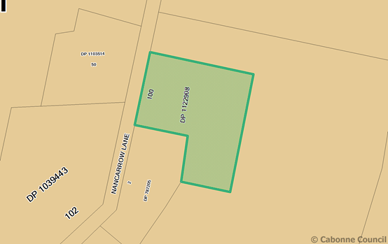
ITEM 21 - DEVELOPMENT
APPLICATION 2017/0055 FOR FARM STAY ACCOMMODATION UPON LOT 100 DP 1122908 BEING
299 NANCARROW LANE, NASHDALE.
REPORT IN BRIEF
|
Reason For Report
|
To obtain
council resolution to refuse the development application as the application
does not comply with the relevant planning provisions.
|
|
Policy Implications
|
Nil
|
|
Budget Implications
|
Nil
|
|
IPR Linkage
|
4.5.3.a - Assess and determine
development applications, construction certificate applications and Onsite
Sewerage Management Systems (OSMS) to meet agreed service levels
|
|
Annexures
|
Nil
|
|
File Number
|
\Development
Applications\DEVELOPMENT APPLICATION\2017\03-2017-0055 - 794514
|
|
Recommendation
THAT:
1. Development Application 2017/0055
for farm stay/bed and breakfast accommodation upon Lot 100 DP 1122908 being
299 Nancarrow Lane, Nashdale be refused as the use is not consistent with the
approved purpose of the allotment as a rural industry; and
2. The applicant and landowner be
advised that condition 6 of the development consent for DA 2007/161 prohibits
the use of the subject building for any form of residential use.
|
Director of Environmental Services' REPORT
|
ADVISORY NOTES
Record
of voting
In
accordance with s375A of the Local Government Act 1993, a division is
required to be called when a motion for a planning decision is put at a
meeting of Council or a Council Committee. A division under s375A of
the Act is required when determining this planning application.
Political
Disclosures
In
accordance with s147(4) of the Environmental Planning and Assessment Act
1979, a person making a planning application to Council is required to
disclose political donations and gifts made within 2 years prior to the
submission of the application and concluding when the application is
determined.
In
accordance with s147(5) of the Environmental Planning and Assessment Act
1979, a person making a public submission to Council in relation to a
planning application made to Council is required to disclose political
donations and gifts made within 2 years prior to the submission being made
and concluding when the application is determined.
Political
donations and gifts (if any) to be disclosed include:
· All
reportable political donations made to any local councillor or Council,
· All
gifts made to any local councillor or employee of the Council.
Nil planning application disclosures have been
received.
Nil public
submission disclosures have been received.
|
SUMMARY
The following
report provides an assessment of the development application submitted for use
of a ‘dwelling’ as farm stay/bed and breakfast accommodation on
land described as Lot 100 in DP 1122908 being 299 Nancarrow Lane, Nashdale.
The
application has been referred to the Council for determination as proposal is
inconsistent with the Cabonne Local Environmental Plan 2012.
It is
recommended that the application be refused.
Applicant: DC
(Partners)Nominees Pty Ltd c/- Mark Smith
Owner: Andrew
B Gartrell
Application signed by Mark Smith as Power of
Attorney
Proposal: Farm
stay accommodation
Location: Lot
100 DP 1122908, 299 Nancarrow Lane, Nashdale
Zone: RU2
Rural Landscape
Background
Lot 100 in DP
1122908 was registered in February 2008, and had been approved by council (DA
2007/161) as an allotment for the purpose of rural industry.
Condition 6
of the development consent for DA 2007/161 states that the dwelling located
upon Lot 100 was to be used only as an office and that no residential use of
the building was permitted. Lot 100 was approved under clause 15 of the Cabonne
Local Environmental Plan 1991 for the purpose of a rural industry.
THE
PROPOSAL
It is
proposed to use an existing building (former dwelling) situated on a 2ha rural
industrial allotment for the purpose of farm stay accommodation.
The proponent
indicated in his Statement of Environmental Effects that the subject building
(approved by development consent DA 2007/ 161) for office use only) is being
used as a manager’s / worker’s residence.
It is
proposed to utilize the building to provide four (4) bedrooms, with shared access
to a kitchen, lounge, bathroom, laundry, library and workshop. A small office
area is proposed. The building has access to a single carport.
Vehicular
access to the property is from Nancarrow Lane.
The proponent
states that the business would operate 7 days per week and indicates the hours
of operation are 10am to 6pm daily. (As the aim of the business is farm stay
accommodation it is assumed however that the proposed activity would actually
operate daily, most likely being in use 24 hours a day).
The proponent
also alludes to future site development in a range of intensive horticulture,
rural industrial uses as well as further dwellings / accommodation, extensive
areas of car and bus parking, on-site water storage and a camping ground. It
should be noted that separate application would be required for intensification
and variation to the current approved use of the land.
Subsequent to
the lodgment of the Development Application on 10 October 2016 and
correspondence issued by council on 24 October 2016, the proponent provided
further correspondence dated 29 November 2016 in which he requested that the
application be altered to a proposed use as a ‘mixture of tourist
accommodation (B&B and/or Farmstay) together with a more limited rural industry
but now viable administrative office (and start-up agronomic operation
including support for glass house protected cropping).
Site Map
MATTERS
FOR CONSIDERATION
Section 79C
of the Environmental Planning and Assessment Act 1979 requires Council
to consider various matters, of which those pertaining to the application are
listed below.
PROVISIONS
OF ANY ENVIRONMENTAL PLANNING INSTRUMENT s79C(1)(a)(i)
Clause 1.2
Aims of the Plan
The broad
aims of the LEP are as follows:
a) to encourage development that complements
and enhances the unique character and amenity of Cabonne, including its
settlements, localities, and rural areas,
(b) to provide for a range of
development opportunities that contribute to the social, economic and
environmental resources of Cabonne in a manner that allows present and future
generations to meet their needs by implementing the principles of ecologically
sustainable development,
(c) to facilitate and encourage
sustainable growth and development that achieves the following:
(i) contributes
to continued economic productivity, including agriculture, business, tourism,
industry and other employment opportunities,
(ii) allows
for the orderly growth of land uses while minimising conflict between land uses
within the relevant zone and land uses within adjoining zones,
(iii)
encourages a range of housing choices and densities in planned urban and rural
locations that is compatible with the residential and rural environment and
meets the diverse needs of the community,
(iv) promotes
the integration of land uses and transport to improve access and reduce
dependence on private vehicles and travel demand,
(v) protects,
enhances and conserves agricultural land and the contributions that agriculture
makes to the regional economy,
(vi) avoids or
minimises adverse impacts on drinking water catchments to protect and enhance
water availability and safety for human consumption,
(vii) protects
and enhances places and buildings of environmental, archaeological, cultural or
heritage significance, including Aboriginal relics and places,
(viii)
protects and enhances environmentally sensitive areas, ecological systems, and
areas that have the potential to contribute to improved environmental, scenic
or landscape outcomes.
Clause 1.9A Suspension of covenants, agreements and
instruments
This clause provided that covenants,
agreements or other similar instruments that restrict the carrying out of
development upon the subject land do not apply unless such are:
· Covenants
imposed or required by council
· Prescribed
instruments under s183A of Crown Lands Act 1989
· Any
conservation agreement under National Parks and Wildlife Act 1974
· Any
trust agreement under the Nature Conservation Trust Act 2003
· Any
property vegetation plan under the Native Vegetation Act 2003
· Any
biobanking agreement under Part 7A of the Threatened Species Conservation Act
1995
· Any
planning agreement made under Division 6 of Part 4 of the Environmental
Planning & Assessment Act 1979
Mapping
The subject site is identified on the LEP maps in the
following manner:
|
Land zoning map
|
Land zoned RU2 Rural Landscape
|
|
Lot size map
|
Minimum lot size N/A
|
|
Heritage map
|
Not a heritage item or conservation area
|
|
Terrestrial Biodiversity Map
|
No biodiversity sensitivity on the subject land
|
|
Flood planning map
|
Not within a flood zone
|
|
Natural resource – karst map
|
Not within a karst area
|
|
Drinking water catchment map
|
Is within a drinking water catchment area
|
|
Riparian land and watercourse map, groundwater
vulnerability map
|
Groundwater vulnerable
|
|
Land reservation acquisition map
|
N/A
|
These
matters are addressed in the report following.
Cabonne
Local Environmental Plan 2012
The subject
land is zoned RU2 Rural Landscape by the Cabonne Local Environmental Plan 2012.
Farm stay accommodation is permissible within this zone, subject to
Council’s development consent. Bed and breakfast accommodation is
permissible land use.
Farm stay
accommodation is defined in the Cabonne Local Environmental Plan 2012 as
follows:
farm stay accommodation means a building or place that provides temporary
or short-term accommodation to paying guests on a working farm as a secondary
business to primary production.
Bed and breakfast accommodation is defined by the Cabonne
Local Environmental Plan 2012 as:
bed and breakfast accommodation means an existing dwelling in which temporary or
short-term accommodation is provided on a commercial basis by the permanent
residents of the dwelling and where:
(a) meals are provided for guests only, and
(b) cooking facilities for the preparation of
meals are not provided within guests’ rooms, and
(c) dormitory-style accommodation is not
provided.
Note. See
clause 5.4 for controls relating to the number of bedrooms for bed and
breakfast accommodation. Bed and breakfast accommodation is a type of tourist
and visitor accommodation—see the definition of that term in this
Dictionary.
Clause 5.4 Controls
relating to miscellaneous permissible uses provides
as follows:
Bed and breakfast accommodation
If development for the purposes of bed and breakfast
accommodation is permitted under this Plan, the accommodation that is provided
to guests must consist of no more than 5 bedrooms.
Note. Any
such development that provides for a certain number of guests or rooms may
involve a change in the class of building under the Building Code of
Australia.
The definition for bed and breakfast accommodation relates
to ancillary use associated with a lawfully occupied residence.
Objectives of the RU2 Rural Landscape zone
The proposal is not inconsistent with the aims of the LEP or
the objectives of the RU2 zone. The development relates to and is
consistent with the zone objectives which seek to
· To encourage
sustainable primary industry production by maintaining and enhancing the
natural resource base.
· To maintain the
rural landscape character of the land.
· To provide for a
range of compatible land uses, including extensive agriculture.
· To encourage
diversity in primary industry enterprises and systems appropriate for the area.
· To provide for a
range of tourism-related uses that support the agricultural industry or are
compatible with agricultural uses.
· To protect
drinking water catchments from the impacts of development by minimising impacts
on the quality and quantity of water entering drinking water storages.
The proposal
however does not satisfy the definition for ‘farm stay
accommodation’ and is inconsistent with the provisions of former Cabonne
LEP 1991 which established the subject land for a specific land use being a
rural industry.
The proposal
does not satisfy the definition for ‘bed and breakfast
accommodation’ and is inconsistent with the current approved land use of
the site, established via the former Cabonne LEP 1991 for a specific land use
being a rural industry.
The use of
the building as an office in association with the approved rural industry
conforms with the development consent issued at the time the allotment was
created by subdivision.
Any
alteration to the approved use as a rural industry for packaging and marketing
cherries would require a separate development application for determination. It
is noted that the proponent indicates a future use of the site for intensive
horticulture including greenhouse construction, and a double storey industrial
building incorporating viewing areas, restaurant, meeting rooms and underground
parking. An assessment has not been undertaken on these activities as the
current development application is specifically for tourism accommodation
within an existing building.
Part 4
– Principal development Standards
There are no
principal development standards that apply to the proposed development.
Part 5
– Miscellaneous provisions
There are no
miscellaneous provisions that apply to the proposed development.
Part 6
– Additional local provisions
Clause 6.4
Groundwater vulnerability
The
objectives of this clause are as follows:
(a) to maintain the hydrological functions of
key groundwater systems,
(b) to protect vulnerable groundwater resources
from depletion and contamination as a result of development.
The subject
land is within an area of mapped moderately high – high groundwater
vulnerability. The development as proposed is unlikely to have an adverse
impact upon environmental issues relating to groundwater.
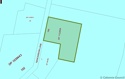
Clause 6.5
Drinking water catchments
The objective of this clause is to protect drinking
water catchments by minimising the adverse impacts of development on the
quality and quantity of water entering drinking water storages.
Council is required to consider:
(a) whether or not the
development is likely to have any adverse impact on the quality and quantity of
water entering the drinking water storage, having regard to the following:
(i) the distance between the development and any
waterway that feeds into the drinking water storage,
(ii) the on-site use, storage and disposal of
any chemicals on the land,
(iii) the treatment, storage and disposal of
waste water and solid waste generated or used by the development,
(b) any appropriate measures
proposed to avoid, minimise or mitigate the impacts of the development.
The
proposal is unlikely to have an adverse impact upon drinking water catchments
as no additional building works are proposed.
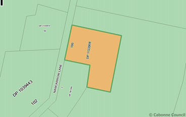
Clause 6.8
Essential services
Council is
satisfied the following essential services that are essential for the
development are available:-
a. The supply of water
b. The supply of electricity
c. The disposal and management of
sewerage
d. Stormwater drainage, &
e. Suitable vehicle access
REGIONAL
ENVIRONMENTAL PLANS
There are no
Regional Environmental Plans that apply to the subject land.
STATE
ENVIRONMENTAL PLANNING POLICIES
State
Environmental Planning Policy 44 – Koala Habitat
Cabonne
Council is identified within the SEPP 44 schedule as having koala habitat. The
applicant has not addressed the SEPP; however, the subject land is generally
cleared and the proposed development will not impact upon any existing
vegetation. There are no known sightings of koalas in the locality, or
sources of koala habitat.
State Environmental
Planning Policy (Rural Lands) 2008
The Rural
Lands SEPP applies to the Cabonne Council area. The SEPP requires Council to
consider the existing and approved uses of land in the vicinity of the
development (when it involves subdivision or dwellings), and whether or not the
development is likely to have a significant impact on predominant or preferred
land uses. The surrounding area consists of agricultural land that is
predominantly used for horticulture.
PROVISIONS
OF ANY DRAFT ENVIRONMENTAL PLANNING INSTRUMENT THAT HAS BEEN PLACED ON
EXHIBITION s79C(1)(a)(ii)
There are no draft environmental plans that relate to the
subject land or proposed development.
PROVISIONS
OF ANY DEVELOPMENT CONTROL PLAN s79C(1)(a)(iii)
Development
Control Plan No 5 – General Rural Zones applies to this development. The
development is not inconsistent with the DCP.
PROVISIONS
PRESCRIBED BY THE REGULATIONS s79C(1)(a)(iv)
The proposal does not contravene the relevant
provisions of the regulations.
THE LIKELY
IMPACTS OF THE DEVELOPMENT s79C(1)(b)
Should the
development proceed it is considered that additional traffic movements will be
generated, as guests arrive and depart, and for the servicing of the building.
The likely
minor increase in traffic along Nancarrow Lane can be accommodated within the
existing road infrastructure.
THE
SUITABILITY OF THE SITE s79C(1)(c)
Physical Attributes and Hazards
There are no
known technological or natural hazards that would affect the proposed
development.
DEVELOPMENT
CONTRIBUTIONS
No
contributions apply to the development.
ANY
SUBMISSIONS MADE IN ACCORDANCE WITH THE ACT s79C(1)(d)
The proposed
development is not advertised development. The proposed development was not
neighbourhood notified.
PUBLIC
INTEREST s79C(1)(e)
The proposed
development is considered to be of minor interest to the wider public due to
the relatively localised nature of potential impacts.
CONCLUSION
The proposed development
does not comply with the relevant land use permissibility for the RU2 zone of
the LEP. A section 79C assessment of the development indicates that the
development is unacceptable in this instance. It is recommended that the
application be refused.
It should
also be noted that no residential occupation of the building is permissible and
that site’s lawfully approved purpose is for a rural industry with
ancillary office.
‘Section
23A of the Local Government Act ‘Council decision making merger proposal
periods’ requires council to consider these guidelines and assess any
impact upon a determination. The guidelines have been considered and the
proposed development and determination for refusal is not contrary to the
guidelines.’
ITEM 22 - DEVELOPMENT
APPLICATION 2017/0012 TWO LOT SUBDIVISION (BOUNDARY ADJUSTMENT), LOT 263 DP 750162
AND LOT 1 DP 1114093, ORANGE ROAD, MANILDRA
REPORT IN BRIEF
|
Reason For Report
|
To obtain
council's refusal of the development application as it is inconsistent with
clause 5.10 and 6.8 of the Cabonne LEP 2012.
|
|
Policy Implications
|
Nil
|
|
Budget Implications
|
Nil
|
|
IPR Linkage
|
4.5.3.a - Assess and determine
development applications, construction certificate applications and Onsite
Sewerage Management Systems (OSMS) to meet agreed service levels
|
|
Annexures
|
Nil
|
|
File Number
|
\Development Applications\DEVELOPMENT
APPLICATION\2017\03-2017-0012 - 794594
|
|
Recommendation
THAT Development
Application 2017/0012 for a two (2) lot subdivision (boundary adjustment) of
Lot 263 DP 750162 and Lot 1 DP 1114093, Orange Road, Manildra be refused as the
development is inconsistent with clause 5.10 and clause 6.8 of the Cabonne
Local Environmental Plan 2012.
|
Director of Environmental Services' REPORT
|
ADVISORY NOTES
Record
of voting
In
accordance with s375A of the Local Government Act 1993, a division is
required to be called when a motion for a planning decision is put at a
meeting of Council or a Council Committee. A division under s375A of
the Act is required when determining this planning application.
Political
Disclosures
In
accordance with s147(4) of the Environmental Planning and Assessment Act
1979, a person making a planning application to Council is required to
disclose political donations and gifts made within 2 years prior to the
submission of the application and concluding when the application is
determined.
In
accordance with s147(5) of the Environmental Planning and Assessment Act
1979, a person making a public submission to Council in relation to a
planning application made to Council is required to disclose political
donations and gifts made within 2 years prior to the submission being made
and concluding when the application is determined.
Political
donations and gifts (if any) to be disclosed include:
· All
reportable political donations made to any local councillor or Council,
· All
gifts made to any local councillor or employee of the Council.
Nil planning
application disclosures have been received.
Nil public
submission disclosures have been received.
|
SUMMARY
The following
report provides an assessment of the development application submitted for the subdivision
(boundary adjustment) on the land described as Lot 263 DP750162 and Lot 1 DP
1114093, Orange Road, Manildra.
It is
recommended that the application be refused as RMS have declined to issue
concurrence for additional vehicular access to Orange Road.
Applicant: Oliver
Bennie
Owner: Oliver
Clive Bennie and Sonya Maree Thornberry
Proposal: Two
lot subdivision (boundary adjustment)
Location: Lot
263 DP750162 and Lot 1 DP 1114093,
Orange Road, Manildra
Zone: R5
– Large Lot Residential
THE
PROPOSAL
It is
proposed to adjust the boundary between two existing allotments having areas
currently of 1.297ha and 7,480m². The subject land is located on the
eastern outskirts of Manildra. The Orange Road (MR 61) runs along the northern
boundary of the land. The site is undulating and drains towards Flash Jacks
Creek and the Mandagery Creek.
The area is
largely cleared of native vegetation, with several isolated trees remaining. A
new dwelling is located towards the southern boundary of Lot 1 DP 1114093. Lot
263 DP 750162 contains a new shed approved for use as an animal breeding
facility (rodents for pet food). A heritage item is identified on the
allotment, being the former Manildra Police Station building (item i152 schedule
5 Cabonne Local Environmental Plan 2012).
It is
proposed to realign the property boundaries to provide the following
allotments:
|
Lot
|
Area
|
Purpose
|
|
3
|
4,006m
|
Large lot
residential
(includes
former police station / heritage item)
|
|
4
|
1.65ha
|
Large lot residential
(includes existing dwelling, storage sheds and animal breeding business)
|
The
development application was lodged on 18 July 2016 and was referred to
council’s Heritage Advisor and the RMS for comment. The proposal was
neighbourhood notified for 14 days and comments sought.
Site Map
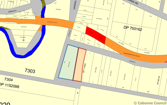
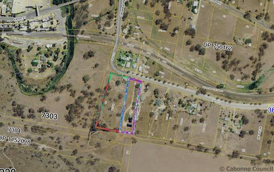
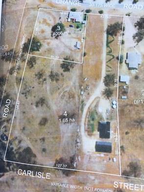
Proposed
subdivision layout
MATTERS
FOR CONSIDERATION
Section 79C
of the Environmental Planning and Assessment Act 1979 requires Council
to consider various matters, of which those pertaining to the application are
listed below.
PROVISIONS
OF ANY ENVIRONMENTAL PLANNING INSTRUMENT s79C(1)(a)(i)
Clause 1.2
Aims of the Plan
The broad
aims of the LEP are as follows:
(a) to encourage development that
complements and enhances the unique character and amenity of Cabonne, including
its settlements, localities, and rural areas,
(b) to provide for a range of
development opportunities that contribute to the social, economic and environmental
resources of Cabonne in a manner that allows present and future generations to
meet their needs by implementing the principles of ecologically sustainable
development,
(c) to facilitate and encourage
sustainable growth and development that achieves the following:
(i)
contributes to continued economic productivity, including agriculture,
business, tourism, industry and other employment opportunities,
(ii) allows
for the orderly growth of land uses while minimising conflict between land uses
within the relevant zone and land uses within adjoining zones,
(iii)
encourages a range of housing choices and densities in planned urban and rural
locations that is compatible with the residential and rural environment and
meets the diverse needs of the community,
(iv) promotes
the integration of land uses and transport to improve access and reduce
dependence on private vehicles and travel demand,
(v) protects,
enhances and conserves agricultural land and the contributions that agriculture
makes to the regional economy,
(vi) avoids or
minimises adverse impacts on drinking water catchments to protect and enhance
water availability and safety for human consumption,
(vii) protects
and enhances places and buildings of environmental, archaeological, cultural or
heritage significance, including Aboriginal relics and places,
(viii)
protects and enhances environmentally sensitive areas, ecological systems, and
areas that have the potential to contribute to improved environmental, scenic
or landscape outcomes.
Clause 1.9A Suspension of covenants, agreements and
instruments
This clause provided that
covenants, agreements or other similar instruments that restrict the carrying
out of development upon the subject land do not apply unless such are:
· Covenants
imposed or required by council
· Prescribed
instruments under s183A of Crown Lands Act 1989
· Any
conservation agreement under National Parks and Wildlife Act 1974
· Any
trust agreement under the Nature Conservation Trust Act 2003
· Any
property vegetation plan under the Native Vegetation Act 2003
· Any
biobanking agreement under Part 7A of the Threatened Species Conservation Act
1995
· Any
planning agreement made under Division 6 of Part 4 of the Environmental
Planning & Assessment Act 1979
Mapping
The subject site is identified on the LEP maps in the
following manner:
|
Land zoning map
|
Land zoned R5 Large Lot Residential
|
|
Lot size map
|
4,000m²
|
|
Heritage map
|
Contains a heritage item (i152 – former Manildra
Police Station c1890s building)
|
|
Terrestrial Biodiversity Map
|
Has biodiversity sensitivity on the subject land
|
|
Flood planning map
|
Not within a flood zone
|
|
Natural resource – karst map
|
Not within a karst area
|
|
Drinking water catchment map
|
Not within a drinking water catchment area
|
|
Riparian land and watercourse map, groundwater
vulnerability map
|
Not affected by riparian, watercourse or groundwater
vulnerability
|
|
Land reservation acquisition map
|
NA
|
These matters are addressed in the report following.
Cabonne
Local Environmental Plan 2012
The subject
land is zoned R5 Large Lot Residential by the Cabonne Local Environmental Plan 2012.
The proposed development is permissible within this zone, subject to
Council’s development consent.
Objectives of the R5 Large Lot Residential zone
The proposal is not contrary to the aims of the LEP or the
objectives of the R5 zone. The development relates to and is consistent
with the zone objectives which seek to
· To provide
residential housing in a rural setting while preserving, and minimising impacts
on, environmentally sensitive locations and scenic quality.
· To ensure that
large residential lots do not hinder the proper and orderly development of
urban areas in the future.
· To ensure that
development in the area does not unreasonably increase the demand for public services
or public facilities.
· To minimise
conflict between land uses within this zone and land uses within adjoining
zones.
Part 4
– Principal development Standards
Clause 4.1
Minimum lot size
The minimum
lot size permissible for subdivision of land within the R5 zone east of
Manildra is 4,000m². The proposed allotments comply with the minimum lot
size standard as the proposed lots will have areas of 4,006m² and 1.65ha.
Part 5
– Miscellaneous provisions
Clause
5.10 Heritage Conservation
An item of heritage significance is located upon
the subject land being identified in schedule 5 of the Cabonne Local
Environmental Plan 2012 as i152 – former Manildra Police Station.
The Cabonne LEP 2012 specifies the consent authority must, before granting
consent under clause 5.10 in respect of a heritage item or heritage
conservation area, consider the effect of the proposed development on the
heritage significance of the item or area concerned. This applies regardless of
whether a heritage management document is prepared or a heritage conservation
management plan is submitted.
The development application was referred to
council’s Heritage Advisor for comment. The comments are provided below:
‘In view of the impacts on
the significance of the LEP Listed heritage item, the subdivision is
recommended for refusal in the present form. A strategy for resolving the
issues was prepared for presentation to the applicant.’
The proposal as submitted does
not provide a conservation management strategy or adequate assessment of the
future use of the identified heritage building.
A search of the National Library
of Australia Trove web site indicates that this building is possibly the only
surviving building of the early Manildra settlement that was established east
of Mandagery Creek and pre dates the current village area. The early Manildra
settlement located east of the creek included a hotel, church, and store. This
information is supported by local history included in the book ‘Manildra
on the Mandagery’.
Initially constructed as a
general store, the subject building became the police station and residence,
replacing an earlier police station that had been located at nearby Meranburn.
The east Manildra police station and residence remained in use until the 1930s
when the current police station was constructed at the corner of Orange and
Derowie streets.
Part 6
– Additional local provisions
Clause 6.3
Terrestrial biodiversity
The lot is
mapped as being biodiversity sensitive land containing Mulga ironbark woodland
on hills. The proposed subdivision does not require the removal of any trees.
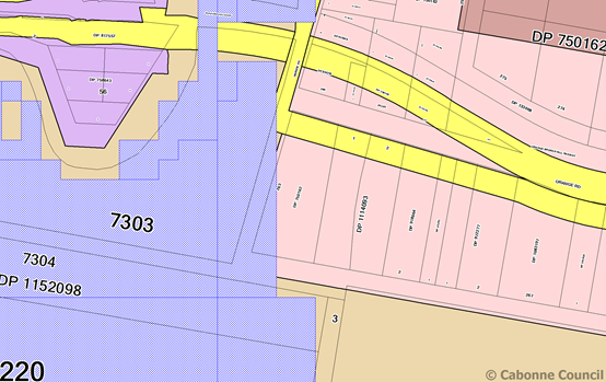
Clause 6.8
Essential services
Council must
be satisfied that the following essential services are available to the
development: -
a. The supply of water
b. The supply of electricity
c. The disposal and management of
sewerage
d. Stormwater drainage, &
e. Suitable vehicle access
Utility
services are available to the existing dwelling and buildings located upon
proposed Lot 4. Utility services can be provided to proposed Lot 4.
The RMS has
not issued its concurrence to vehicular access arrangements for proposed Lot 3.
A significant safety issue affects the proposed access point due to its
proximity to a 90-degree bend in the Orange Road (MR 61).
REGIONAL
ENVIRONMENTAL PLANS
There are no
Regional Environmental Plans that apply to the subject land.
STATE
ENVIRONMENTAL PLANNING POLICIES
State
Environmental Planning Policy 55 – Remediation of land
This SEPP
applies to the land. No soil contamination testing has been undertaken for the
proposed Lot 3. A detailed history of the use of the subject land, other than
as a store and a police station, is unknown. Based on the two known land uses
it is considered unlikely that site contains contaminated land. The matter may
be considered further should additional development be proposed for the
holding.
PROVISIONS
OF ANY DRAFT ENVIRONMENTAL PLANNING INSTRUMENT THAT HAS BEEN PLACED ON
EXHIBITION s79C(1)(a)(ii)
There are no draft environmental plans that relate to the
subject land or proposed development.
PROVISIONS
OF ANY DEVELOPMENT CONTROL PLAN s79C(1)(a)(iii)
Development
Control Plan 6 – Rural Small Holdings applies to this land. The
subdivision is not inconsistent with the DCP.
PROVISIONS
PRESCRIBED BY THE REGULATIONS s79C(1)(a)(iv)
The proposal does not contravene the relevant provisions of the
regulations.
THE LIKELY
IMPACTS OF THE DEVELOPMENT s79C(1)(b)
Siting
/location
The proposed
subdivision is located on the eastern approach to the village of Manildra and
is set within an area of established large lot residential allotments.
The proposal
seeks to effect a boundary adjustment between two allotments. The future use of
proposed Lot 3 has not been specified. Proposed Lot 4 contains a dwelling,
storage sheds and animal breeding business.
Access and traffic
The
development proposal was referred to the RMS for comments as lawful access to
proposed Lot 3 is sought off a classified road being Orange Road (MR62). The
proposed vehicular access point is in close proximity to a 90-degree bend and
does not achieve the minimum safe intersection sight distance necessary to
provide a high level of safety between turning and through traffic on Orange
Road.
The RMS in
correspondence dated 31 August 2016 requested that the proponent amend the
subdivision plans to show all vehicular access to the development obtained via
the existing vehicular access from Orange Road (and servicing Lot 1 DP 1114093
being the location of continued access for proposed Lot 4. The RMS comments
have been referred to the proponent however amended plans have not been
forthcoming.
The RMS has
not provided its concurrence to the development proceeding, therefore council
is unable to consider a determination of the application for approval.
THE
SUITABILITY OF THE SITE s79C(1)(c)
Physical Attributes and Hazards
There are no
known technological or natural hazards that would affect the proposed
development.
DEVELOPMENT
CONTRIBUTIONS
No
contributions apply to the development.
ANY
SUBMISSIONS MADE IN ACCORDANCE WITH THE ACT s79C(1)(d)
The proposed
development was neighbourhood notified and no submissions were received during
the notification phase.
PUBLIC
INTEREST s79C(1)(e)
The proposed
development is considered to be of minor interest to the wider public due to
the relatively localised nature of potential impacts.
CONCLUSION
The proposed
development is permissible with the consent of Council. The development
complies with the relevant aims, objectives but is inconsistent with clause
5.10 and 6.8 of the LEP. A section 79C assessment of the development
indicates that the development is not acceptable in this instance. The
application is recommended for refusal.
Section 23A
of the Local Government Act ‘Council decision making merger proposal
periods’ requires council to consider these guidelines and assess any
impact upon a determination. The guidelines have been considered and the
proposed development and determination for refusal is not contrary to the
guidelines.
ITEM 23 - DEVELOPMENT
APPLICATION 2016/0128 FOR PROPOSED OPEN CUT MINE (LIMESTONE MINE) AND ANCILLARY
PROCESSING - PROPOSED LOTS 100 & 101 IN SUBDIVISION OF LOT 2 DP 590034, LOT
136 DP 664861 AND LOT 137 DP 652082, BEING LAND KNOWN AS 115 CANOMODINE LANE,
CANOWINDRA.
REPORT IN BRIEF
|
Reason For Report
|
For
determination of council due to submissions received
|
|
Policy
Implications
|
Nil
|
|
Budget
Implications
|
Nil
|
|
IPR Linkage
|
4.5.3.a -
Assess and determine development applications, construction certificate
applications and Onsite Sewerage Management Systems (OSMS) to meet agreed
service levels
|
|
Annexures
|
1. Notice of Consent⇩
2. Westlime Pty Ltd
document to support ⇩
|
|
File Number
|
\Development
Applications\DEVELOPMENT APPLICATION\2016\03-2016-0128 - 797079
|
|
Recommendation
THAT Development Application 2016/0128 for an open cut mine (limestone
mine) and ancillary processing upon land describes as proposed Lots 100 &
101 in a subdivision of Lot 2 DP 590034, Lots 136 DP 664861 and Lot 137
DP 652082, known as 115 Canomodine Lane, Canowindra, be granted consent
subject to the conditions attached.
|
Director of Environmental Services' REPORT
|
ADVISORY NOTES
Record of voting
In accordance with s375A of the Local Government Act 1993, a
division is required to be called when a motion for a planning decision is
put at a meeting of Council or a Council Committee. A division under
s375A of the Act is required when determining this planning application.
Political Disclosures
In accordance with s147(4) of the Environmental Planning and Assessment
Act 1979, a person making a planning application to Council is required to
disclose political donations and gifts made within 2 years prior to the
submission of the application and concluding when the application is
determined.
In accordance with s147(5) of the Environmental Planning and
Assessment Act 1979, a person making a public submission to Council in
relation to a planning application made to Council is required to disclose
political donations and gifts made within 2 years prior to the submission
being made and concluding when the application is determined.
Political donations and gifts (if any) to be disclosed include:
· All reportable political donations made to any local councillor or
Council,
· All gifts made to any local councillor or employee of the Council.
No planning application disclosures
have been received. No public submission disclosures have been
received.
|
Introduction
The following planning assessment report was included in the
council’s November business paper. The proponent addressed the council at
its meeting and requested the item be deferred and invited the councillors to
carry out a site inspection prior to consideration of the application. Council
resolved accordingly. A site inspection was undertaken on 6 December 2016.
The proponent has submitted correspondence seeking variation to
three draft conditions of consent (copy attached). Variation is sought to the
following conditions:
Condition 10 – Biodiversity Offset area
The proponent seeks approval for a Biodiversity offset area of 41.3
ha rather than the requirement for a minimum area of 55ha as previously
recommended by the NSW Department of Environment and Heritage.
Condition 20 – Road design and construction (Canomodine Lane)
The proponent seeks a reduction in the road surface seal from 10m
down to 8m)
Condition 28 – Road upgrades
The proponent seeks approval to commence mining and processing
activity onsite prior to completion of road system upgrade works, to enable
road base to be provided from the site for the roadworks.
Planning assessment report
The following report provides an assessment of the development
application 2016/128 submitted for an open cut mine (limestone
mine) upon proposed Lots 100 and 101 in a subdivision of Lot 2 DP 590034, Lot
136 DP 664861 and Lot 137 DP 652082, being land known as 115 Canomodine Lane,
Canowindra.
Section 23A of
the Local Government Act ‘Council decision making merger proposal
periods’ requires council to consider these guidelines and assess any
impact upon a determination. The guidelines have been considered and the
proposed development and determination for support is not contrary to the
guidelines.
Applicant: Westlime
Quarries Pty Ltd
(Aidan, Andrew and Nick Commins)
Owner: Phillip
Wythes
Proposal: Open
cut mine
Location: Proposed
Lots 100 and 101 in a subdivision of Lot 2 DP 590034, Lot 136 DP 664861 and Lot
137 DP 652082, being land known as 115 Canomodine Lane,
Canowindra.
Zone: RU1
Primary Production
Capital Value: $4,500,000
It is recommended that the application be approved subject to the
attached conditions of consent.
Summary
Westlime Quarries Pty Ltd proposes to establish and operate an open
cut limestone mine upon part of a rural holding located approximately half way
between Cargo and Canowindra, accessed off Canomidine Lane. Westlime proposes
to extract and process on-site up to 250,000 tonnes per annum of limestone over
a period of 27 years, for sale and distribution locally and regionally.
Description of site
The development is located 13km north east of Canowindra and is
described as proposed Lots 100 and 101 in a subdivision
of Lot 2 DP 590034, Lot 136 DP 664861 and Lot 137 DP 652082, being land known
as 115 Canomodine Lane, Canowindra. The subject holding has an area
of 218.3ha, of which the project area for the mine occupies an irregular shaped
area of 12.3ha at the eastern end of the property, with a 43ha Biodiversity
Offset area generally located along the northern section of the holding.
Surrounding land is typically utilized for grazing and cropping
activities (extensive agriculture). The nearest dwelling to the proposed mine
is located within the property approximately 1,150m to the south west. The
nearest dwelling not associated with the proposed mine is located 1,450m to the
south west of the mine.
The subject property has been used for agriculture, grazing and
cropping. The site contains cleared farm land, limestone outcrops and remnant
native vegetation. The remnant vegetation areas are classified as Endangered
Ecological Community under the NSW Threatened Species Act 1995 and the
Commonwealth Environmental Protection and Biodiversity Conservation Act 1999.
An item of Aboriginal cultural significance has been identified upon the
holding. A section of the proposed mine area has previously been subject to a
small scale bauxite mine, the former mine now collapsed.
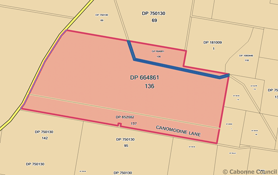 Site map
 Aerial view of site
THE PROPOSAL
The applicant seeks development consent for an open cut mine
(limestone mine) upon land currently known as 115 Canomodine Lane,
Canowindra. The area of the proposed mine has extensive outcrops of
limestone and is subject to karst development with sinkholes and solution
features located throughout the site.
Laboratory testing of the limestone indicated the purity of the
limestone observed at surface level extends at least to a depth of 21m and that
the material is generally high purity and likely to be suitable for the
following uses:
· Agricultural lime
· Concrete aggregate
· Cement manufacture
· Plastics filler
· Steel making flux
· Soda ash manufacture
Further site drilling indicated clay filled cavities within the
limestone with no groundwater intercepted in any of the drill holes.
The proposal involves the extraction and processing of limestone
with an annual maximum production of 250,000 tonnes with an average annual
production of 150,000 tonnes. The extraction process will be by blast and drill
techniques within an open cut mine operation. Material would be extracted by an
excavator or front end loader and transported to the processing plant using
off-road trucks.
The proposal would provide:
· extraction of up to 250,000 tonnes per annum of limestone and
related material from the site for a period of 27 years
· processing on-site of the extracted material to produce a range of
products including agricultural lime
· transportation of that material via the existing network of public
roads
· ancillary activity including construction and use of site
infrastructure
The development would comprise of:
· Construction of internal haul road, site clearing and infrastructure
establishment
· Construction of an access road intersection off Canomodine Lane and
into the mine site
· Upgrade and sealing of Canomodine Lane from the site access road
west to the intersection with Cargo Road, including construction within the
Canomodine Lane road reserve of a truck holding area and a school bus stopping
area. A designated area, located either within the Canomodine Road reserve or
upon the land owner’s holding is to be established as a sealed truck
holding bay to accommodate traffic arriving prior to the 6am opening time of
the mine. Canomodine Lane is to upgraded and sealed, with a pavement life of 27
years. It is noted that currently Canomodine Lane is not an authorized B-Double
truck route.
· Upgrade of the intersection of Canomodine Lane and Cargo Road
(MR237)
· Upgrade of Cargo Road (MR237) to the south west of its intersection
with Canomodine Lane, including construction of vehicle turn lanes and road
works to improve sight distance. The road in the vicinity of an existing rise is
to be lowered approximately 1.9m to facilitate adequate sight distance for
traffic
· Extraction of limestone and weathered material within a 12.7ha area
over a span of 27 years to a maximum extraction rate of 250,000 tonnes per
annum
· On-site crushing, screening, grinding and stockpiling of extracted
materials for uses including road base, agricultural lime, industrial
carbonate, horticultural products and general fill. The processing operation
requires establishment of crushing and screening plant, 500 tonne silo,
associated hopper and conveyor, ball mill and associated classifier and lime
shed with a fine grinding circuit within the lime shed.
· Transportation of product from the site using rigid trucks, truck
and dog, semi-trailers and B-Double trucks
· Establishment of ancillary infrastructure including water management
structures, workshop, weighbridge and on-site offices
· Construction and rehabilitation of final landform that would be
geotechnical stable and suitable for grazing land use
The mine site is proposed to operate between 6am and 6pm Monday to
Friday with product grinding operations to occur 24 hours daily. Between 8 and
12 persons will be employed at the mine, with additional employment to truck
drivers and other contractors. Traffic generation from transport of limestone
product from the site is estimated at an average of 15 truck (30 vehicle
movements) per day reaching a maximum of 60 trucks (120 vehicle movements) per
day. At maximum operation truck movements are calculated as 10 trucks (20
vehicle movements) per hour.
The proponent indicates that all laden trucks leaving the site would
make left hand turns from Canomodine Lane onto Cargo Road travelling towards
the Cudal – Canowindra Road. At the Cudal - Canowindra Road an estimated
80% of truck traffic would travel south through Canowindra with 20% of trucks
travelling north towards Cudal. The proponent further indicates that unladen
trucks would approach the site from the Canowindra approach with access from
the northern approach denied. Light vehicles would enter Canomodine road from
both approach directions.
The proponent has indicated that they are prepared to enter into an
agreement with council for the payment of monetary contributions to the council
for the ongoing maintenance of the local road system impacted by the mine
traffic (Cargo Road between Canomodine Lane and the Canowindra-Cudal road
intersection) for the life of the mine. The proponent proposes to upgrade
Canomodine Lane from its intersection with Cargo Road to the eastern side of
the mine access road, and to maintain that section of road pavement for the
life of the mine.
The extraction operation would be implemented in the following
stages:
· Initial 12 months – site establishment
· Years 1-5 eastern extraction area cleared, temporary processing and
stockpile areas constructed, installation of mobile processing plant,
construction of site access road and temporary stage 1 access road, work within
the local road reserves, construction of Ball Mill and associated
infrastructure, production commenced and stockpiling of ground lime products,
install fixed crushing and screening plant.
· Years 6-9 extension of extraction area west northwest, introduction
of permanent mining fleet and establishment of multiple operational benches.
· Years 10-27 ongoing development of extraction area to full approval
extent and progressive rehabilitation of completed sections of the mine area.
· Years 27-30 site rehabilitation operations
The final floor of the open cut mine area would be 28m lower than
the existing surface level. Blasting will be undertaken only during the
hours of 9am and 5pm Monday to Saturday, with no more than one blast scheduled
per day. A protocol for liaising with neighbours to advice of the blasting schedule,
and to provide an environmental complaints hotline contact number will be
implemented as part of the mine operation procedures.
Limestone material will be transported from the excavation site to
the processing area where material will be crushed and milled, then stored
prior to sale and transportation off site. Equipment required on-site will
include a primary jaw crusher, one or more mobile crushers, screening
crusher(s) and conveyors, fixed processing plant.
Extracted material will be transferred from the mine area to the
processing plant and will be loaded into a hopper and processed through a
primary and secondary crusher then screened and stockpiled. The material will
then be loaded into a hopper feeder to a silo and passed into the ball mill. A
fine grinding circuit is to be added to the procedure to produce ultra-fine
product.
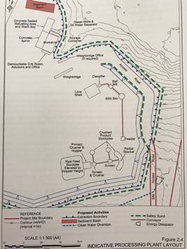
Potable water is to be transported to the site for purposes of
drinking water supply. Rain water collection and tank storage will provide
water supply to amenities Primary water source for operational activities will
be from surface water collected in a sediment basin and pumped for use within
the processing operation. The proponent also proposes to construct a bore in
the vicinity of the workshop, subject to obtaining a Water Access License and
the purchase of sufficient water allocation to ensure an adequate operational
water supply. The approval for the production bore has been deferred from the
current application. Water sources for initial site works ie dust suppression,
is to be provided via water trucked to the site and stored in tanks.
Power is to be provided to the site by installation of an on-site
power generation by way of two silenced diesel powered generators. The plant
will service the crushing and screen plant, grinding plant and workshop. The
crib room, office, water treatment plant, weighbridge and ancillary
infrastructure are to be provided with solar power and if required, battery
backup.
All site communication would be provided by mobile phone or two-way
radio links.
Other than concept plans, no detailed plans or elevations have been
provided with the development application for any of the proposed buildings or
structures. All building works (other than exempt development criteria) will
require separate submission of development applications and construction
certificates to the relevant authority.
The subject land contains Endangered Ecological Community (EEC)
being White Box – Blakely’s Red Gum - Yellow Box grassy woodland of
the NSW south western slopes bioregion and derived tussock grasslands of the
central western plains and lower slopes of NSW. The proponent proposes to
implement a Biodiversity Offset Strategy to compensate for the disturbance of
native vegetation. An off-set of 43.3ha is proposed and is to be secured
through a conservation Property Vegetation Plan to be prepared under the Native
Vegetation Act 2002. The plan is to be submitted by the land owner to the
Central Tablelands Local Land Services for assessment.
The proponent will establish and facilitate a Community Consultative
Committee in accordance with the guidelines issued by the Department of
Planning – Guidelines for establishing and operating community
consultative committees for mining projects, June 2007 (currently subject to
review). The facilitation of a committee ensures transparent community
engagement between the mine operators, nearby residents and the local
council.
The socio economic impact of the proposed mine includes employment
of between 8 and 12 persons, with additional employment for contract
transportation personnel, ongoing contributions to the local / regional / State
economies through approximately $3.5m in wages and salaries/ purchase of goods
and services, contractors/suppliers, rates and taxes.
The proposed development is classified as ‘Designated
Development’ under clause 25 of schedule 3 of the Environmental Planning
and Assessment Regulations 2000 as the development would result in disturbance
of more than 2ha of land. The development does not trigger Regional or State
Significance and may be determined by council as the local consent authority.
The proposal is considered to be Integrated Development under s91 of
the Environmental Planning and Assessment Act 1979.
Background
On 5 June 2015 a planning focus meeting was facilitated by RW
Corkery & Co on behalf of the proponent. A briefing meeting was held at the
Cargo Hall prior to a site familiarization visit.
In August 2015 the land owner lodged an application for a two (2)
lot subdivision of the subject property to create proposed Lot 100 having an
area of 118.32ha contained cultivated farm land and an existing dwelling with
ancillary outbuildings. Proposed Lot 101 has an area of 100ha and contains the
proposed mine site and farm land. Development Consent was granted on 11
February 2016, and a modification to the application approved on 6 April 2016.
An access compliance certificate was issued for provision of vehicular access
to proposed Lot 101 on 16 August 2016. The subdivision has not been registered
with the Lands Tiles Office to date.
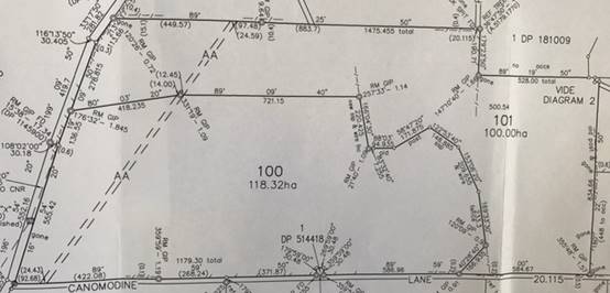
Approved subdivision of subject land
Development Application 2016/128 and associated Environmental Impact
Statement for the establishment of a limestone mine and ancillary material
processing was lodged with council on 7 April 2016. The application was
referred as designated and integrated development on 11 April 2016 to the NSW Department
of Industry Division of Resources and Energy, NSW Office of Environment and
Heritage, NSW Roads and Maritime Services, NSW Office of Water and NSW
Environment Protection Authority. Additional information was subsequently
sought by EPA, RMS, DPI Water, and OEH.
The application was advertised and also neighbourhood notified on 12
April 2016 with public submissions received up until 5pm on 13 May 2016.
The state agency and public submissions were forwarded to the
proponent for comment and a Response to Submissions was received August 2016.
The Response to Submissions document was circulated to the State agencies for
further review.
General terms of approval were issued by EPA on 4 May 2016,
Department of Industry on 13 May 2016, OEH on 29 August 2016, DPI Water on 30
August 2016, and RMS on 21 October 2016.
Amendments to the initial development proposal
The Response to Submissions document amended the development
proposal by including a small parcel of Crown land (unnamed) within the project
site that previously had not been identified on public cadastral databases.
The biodiversity offset area was amended by increasing the 41.3ha
offset area by 2ha to account for a possible future dwelling to be sited upon
the property. It should be noted that no development consent for a dwelling has
been obtained, nor is there a requirement of the subdivision DA 2016/028 for a
Building Envelope to be registered upon the approved agricultural allotment
being proposed Lot 101.
The proposed production bore has been withdrawn from the current
application. Instead the proposed bores identified as MB1, MB2, Site A and Site
B will be constructed as monitoring bores only, with applications for a test
bore and production bore to be separately submitted at a later time based upon
the results of the monitoring bores. The proponent intends to truck water to
the site for use during the initial construction phase.

Mine lease area and proposed biodiversity offset areas
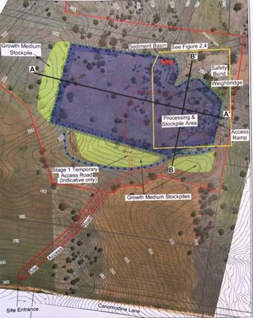
Proposed activities – project site
PLANNING ASSESSMENT
Legislative requirements (Environmental Planning & Assessment
Act 1979)
Designated Development (Environmental Planning & Assessment
Regulations 2000)
The proposed development is considered to be Designated Development
as per the Environmental Planning & Assessment Regulation, 2000, Part 1 of
Schedule 3 Designated Development, 20 Limestone mines and works:
(1) Limestone mines or works that disturb a
total surface area of more than 2 hectares of land (being land associated with
a mining lease or mineral claim under the Mining Act 1992 ) by:
(a) clearing or
excavating, or
(b) constructing
dams, ponds, drains, roads, railways or conveyors, or
(c) storing or
depositing overburden, limestone or its products or tailings.
(2) Mines that mine or process limestone
and are located:
(a) in or within
40 metres of a natural waterbody, wetland, a drinking water catchment or an environmentally sensitive area, or
(b) if involving
blasting, within 1,000 metres of a residential zone or within 500 metres of a
dwelling not associated with the mine, or
(c) within 500
metres of another mining site that has operated within the past 5 years.
(3) Limestone works (not associated with a
mine):
(a) that crush,
screen, burn or hydrate more than 150 tonnes per day, or 30,000 tonnes per
year, of material, or
(b) that are
located:
(i) within 100 metres of a natural waterbody or wetland, or
(ii) within 250
metres of a residential zone or a dwelling not associated with the development.
The development proposal is for a limestone mine that will disturb a
total surface area of more than 2ha of land, being a proposed extraction area
of 12.3ha.
Integrated development (s91 Environmental Planning & Assessment
Act 1979.
The development is considered to be Integrated Development as
defined under section 91 of the Environmental Planning & Assessment Act
1979 as an Environmental Protection License is required to operate the mine.
In addition to development consent under the Environmental Planning
& Assessment Act 1979, the proponent will also be required to obtain an
Environmental Protection License under the Protection
of the Environmental Operations Act 1997, Mining (Mineral Owner) Lease,
Controlled Activity Permit under s91 Water Management Act 2000 and a s138
permit under the Roads Act 1993.
ASSESSMENT (s79C(1))
MATTERS FOR CONSIDERATION
Section 79C of the Environmental Planning and Assessment Act 1979
requires Council to consider various matters, of which those pertaining to the
application are listed below.
PROVISIONS OF ANY ENVIRONMENTAL PLANNING INSTRUMENT s79C(1)(a)(i)
Clause 1.2 Aims of the Plan
The broad aims of the LEP are as follows:
a) to encourage
development that complements and enhances the unique character and amenity of
Cabonne, including its settlements, localities, and rural areas,
(b) to provide
for a range of development opportunities that contribute to the social,
economic and environmental resources of Cabonne in a manner that allows present
and future generations to meet their needs by implementing the principles of
ecologically sustainable development,
(c) to
facilitate and encourage sustainable growth and development that achieves the
following:
(i) contributes to continued economic productivity, including
agriculture, business, tourism, industry and other employment opportunities,
(ii) allows for the orderly growth of land uses while minimising
conflict between land uses within the relevant zone and land uses within
adjoining zones,
(iii) encourages a range of housing choices and densities in planned
urban and rural locations that is compatible with the residential and rural
environment and meets the diverse needs of the community,
(iv) promotes the integration of land uses and transport to improve
access and reduce dependence on private vehicles and travel demand,
(v) protects, enhances and conserves agricultural land and the
contributions that agriculture makes to the regional economy,
(vi) avoids or minimises adverse impacts on drinking water
catchments to protect and enhance water availability and safety for human
consumption,
(vii) protects and enhances places and buildings of environmental,
archaeological, cultural or heritage significance, including Aboriginal relics
and places,
(viii) protects and enhances environmentally sensitive areas,
ecological systems, and areas that have the potential to contribute to improved
environmental, scenic or landscape outcomes.
Clause 1.9A
Suspension of covenants, agreements and instruments
This clause
provided that covenants, agreements or other similar instruments that restrict
the carrying out of development upon the subject land do not apply unless such
are:
· Covenants imposed or required by council
· Prescribed instruments under s183A of Crown Lands Act 1989
· Any conservation agreement under National Parks and Wildlife Act
1974
· Any trust agreement under the Nature Conservation Trust Act 2003
· Any property vegetation plan under the Native Vegetation Act 2003
· Any biobanking agreement under Part 7A of the Threatened Species
Conservation Act 1995
· Any planning agreement made under Division 6 of Part 4 of the
Environmental Planning & Assessment Act 1979
Mapping
The subject site
is identified on the LEP maps in the following manner:
|
Land zoning
map
|
Land zoned RU1
Primary Production
|
|
Lot size map
|
Minimum lot
size - NA
|
|
Heritage map
|
Not a heritage
item or conservation area
|
|
Terrestrial
Biodiversity Map
|
Has
biodiversity sensitivity on the subject land
- Endangered Ecological
Community, Blakeley’s Red Gum - Yellowbox grassy woodland
|
|
Flood planning
map
|
Not within a
flood zone
|
|
Natural
resource – karst map
|
Within a karst
area
|
|
Drinking water
catchment map
|
Not within a
drinking water catchment area
|
|
Riparian land
and watercourse map, groundwater vulnerability map
|
Riparian,
watercourse or groundwater vulnerability
|
|
Land
reservation acquisition map
|
NA
|
These
matters are addressed in the report following.
Cabonne Local Environmental Plan 2012
The subject land is zoned RU1 Primary Production by the Cabonne
Local Environmental Plan 2012. An open cut mine (limestone mine) is
permissible within this zone, subject to Council’s development consent.
Objectives of the
RU1 Primary Production zone
The proposal is
not contrary to the aims of the LEP or the objectives of the RU1 zone.
The development is considered to be not contrary to the zone objectives which
seek to
· To encourage sustainable primary industry production by maintaining
and enhancing the natural resource base.
· To encourage diversity in primary industry enterprises and systems
appropriate for the area.
· To minimise the fragmentation and alienation of resource lands.
· To minimise conflict between land uses within this zone and land
uses within adjoining zones.
· To enable function centres, restaurants or cafes and appropriate
forms of tourist and visitor accommodation to be developed in conjunction with
agricultural uses.
Part 6 – Additional local provisions
Clause 6.3 Terrestrial biodiversity
The objective of this clause is to maintain terrestrial biodiversity
by:
a. Protecting native
fauna and flora, and
b. Protecting the
ecological processes necessary for their continued existence, and
c. Encouraging the
conservation and recovery of native fauna and flora and their habitats.
The subject land is identified as having terrestrial biodiversity,
Endangered Ecological Community - Blakely’s Red Gum - Yellowbox
Woodland and derived tussock grassland.
The EIS identifies that vegetation communities disturbed by the
development proceeding relate to approximately 16.4ha of White Box –
Blakely’s Red Gum – Yellow Box grassy woodland of the NSW South
Western Slopes Bioregion, an Endangered Ecological Community (EEC) under the
NSW Threatened Species Conservation Act, 1995, and approximately 1.76ha of
Derived tussock grasslands of the central western plains and lower slopes of
NSW.
This terrestrial biodiversity is a predominantly located on the
eastern side of the site being the area proposed for the open cut mine.
The EIS indicated twenty-two (22) species and two (2) EECs listed
under the Threatened Species Conservation Act have potential to occur within
the subject area, and seven (7) protected species listed under the Commonwealth
Environmental Protection and Biodiversity Act 1999.
The EIS indicates that with the implementation of management and
mitigation measures, the proposed development was considered to be unlikely to
have a significant impact on any of the identified species or EEC.
It is considered that land clearing in association with this
development requires council’s development consent. The assessment of
clearing vegetation forms has been addressed in the EIS, the RTS and within
this report.
It is proposed to implement a Biodiversity Offset Strategy to offset
vegetation clearing impacts, including a proposed 43ha biodiversity offset
area. The Office of Environment and Heritage (OEH) have reviewed the EIS and
RTS and are not satisfied that the offset strategy as proposed adequately
offsets the impact to Box Gum Woodland EEC. OEH recommend additional areas of
Box Gum Woodland EEC or derived native grassland be sourced to provide a
minimum offset area of 55ha. A recommendation based upon the OEH recommendations
is included in the draft notice of approval.
The proposal is not inconsistent with clause 6.3 terrestrial
biodiversity.
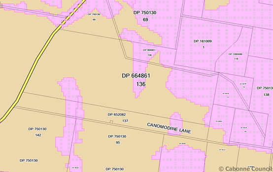
Clause 6.4 Ground water vulnerability
The
objectives of this clause are as follows:
(a) to maintain the hydrological functions of
key groundwater systems,
(b) to protect vulnerable groundwater resources
from depletion and contamination as a result of development
The proponent has addressed the
hydrogeology of the area in the submitted EIS and demonstrated that appropriate
measures can be implemented to ensure the protection of the groundwater within
the area.
Clause 6.6 Riparian land and watercourses
The
objective of this clause is to protect and maintain the following:
(a) water quality within watercourses,
(b) the stability of the bed and banks of
watercourses,
(c) aquatic and riparian habitats,
(d) ecological processes within watercourses and
riparian areas.
The submitted EIS addresses the mitigation measures proposed to
ensure the protection of water quality, particularly associated with the nearby
Grove Creek. There is potential for runoff from the development and this
is proposed to be managed by erosion and sediment control, sediment basin
and on-site clean water diversion.
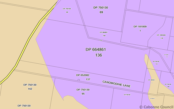
Clause 6.7 Land affected by karst
The objective of this clause is to ensure that development,
in areas of subsidence risk from karst, matches the underlying geotechnical
conditions of the land, is restricted on unsuitable land and does not endanger
life or property.
The proposal satisfies the development standard. The area
forms part of a karst environment, with known caves situated in similar geology
nearby. The EIS notes presence across the development sit of solution cavities
and sink holes. The proponent is encouraged to engage with geologists and
speleologists in the event that a cave or cave system is located during mining
activity.
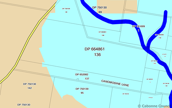
COMMONWEALTH LEGISLATION
Environmental Protection & Biodiversity Conservation Act 1999
An ecological assessment by OzArk Environmental Heritage and
Management Pty Ltd accompanied the EIS. The report confirmed that the proposed
development would not adversely impact upon any matter of natural environmental
significance.
REGIONAL ENVIRONMENTAL PLANS
There are no Regional Environmental Plans that apply to the subject
land.
STATE ENVIRONMENTAL PLANNING POLICIES
State (State and Regional Development) 2011. The proposal does not meet the capital investment value threshold
for assessment as either State or regional development.
State Environmental Planning Policy (Mining, Petroleum Production
and Extractive Industries) 2007 specifies matters
requiring consideration in an assessment of any mining, petroleum or extractive
industry. The proposed open cut mine meets the relevant aims of the Policy with
regard to orderly economic use of land, while addressing the ecological and
environmental issues. The proposal is permissible with consent where
agriculture may be carried out. The ancillary processing is a permissible use.
While there are extensive areas of land available for agricultural
activity, there are limited areas for mining of limestone on a commercially
viable scale. The proponent in the EIS has committed to rehabilitation of the
subject land at the conclusion of the operation.
If approved the mine will be subject to conditions of consent
including General Terms of Approval (GTA) by EPA and RMS.
Access to the site will be by public roads, there being no
alternative form of transport option available to the proponent.
State Environmental Planning Policy (Infrastructure) 2007. The development does not meet the 200 or more vehicle movements
per day criteria for consideration under the SEPP, however the application was
referred to RMS for comment and GTA.
State Environmental Planning Policy No. 33 Hazardous and offensive
development
The proposed development is not classified as a potential hazardous
or offensive industry. It is noted that the site will however store diesel,
oils and hydrocarbon goods, as well as explosives. These goods will be stored
ion-site in controlled areas.
State Environmental Planning Policy No. 44 – Koala Habitat
Protection applies to the Cabonne Council area.
There are no known sightings of koalas in the locality of the subject land. The
OzArk ecological report submitted with the EIS concluded that sporadic
transient koala movements may occur in the project site.
State Environmental Planning Policy No. 55 Remediation of Land. The subject land has been utilized for agriculture, in particular
livestock grazing, and it is considered that the historical land use is
unlikely to have resulted in land contamination.
State Environmental Planning Policy (Rural Lands) 2008
The relevant aim of this policy relates to ‘measures designed
to reduce land use conflicts’. The proposal is not contrary to the rural
planning principles as noted in part 2 of the SEPP.
PROVISIONS OF ANY DRAFT ENVIRONMENTAL PLANNING INSTRUMENT THAT HAS
BEEN PLACED ON EXHIBITION s79C(1)(a)(ii)
There are no draft environmental plans that
relate to the subject land or proposed development.
PROVISIONS OF ANY DEVELOPMENT CONTROL PLAN s79C(1)(a)(iii)
Development Control Plan No 5 – General Rural Zones applies to
this development. The proposal generally complies with the DCP provisions.
PROVISIONS PRESCRIBED BY THE REGULATIONS s79C(1)(a)(iv)
As described within this report,
various matters regarding the nature of the proposal, the consent authority and
advertising have been addressed.
THE LIKELY IMPACTS OF THE DEVELOPMENT s79C(1)(b)
Context & Setting
The proposed mine site is located in an area of south sloping
undulating hills situated between two northeast- southwest ridgelines. The site
is surrounded by grazing and cultivation land. To the east are Cargo and
Canomodine creeks which flow into the Belubula River 3km to the south of the
subject land. Two unnamed watercourses transect the subject land.
To the east of the site is Black Rock Ridge, while Mount Canobolas
is situated to the north east of the area. The village of Cargo is located
approximately 13km to the north of the subject land. Canowindra is located
approximately 13km to the south west.
Five dwellings are located within a radius of 3km of the proposed
mine. The nearest residence is located xxm from the mine lease area and is
occupied by the owner of the subject land. Central Tablelands Water
infrastructure is located adjacent to Canomodine Lane with a pump station
located immediately west of the mine site.
Adequate measures can be undertaken to minimse any adverse impact
upon adjacent land as a result of the development proceeding, and the proposal
is considered to be appropriate in terms of addressing context and setting.
Separate development consent will be required for any proposed
structural building works including the weighbridge, site office, amenities,
crib room, workshop any proposed storage shed that does not satisfy provisions
for exempt and complying development. Approval will also be required under the
Local Government Act 1993 for the proposed on site waste management system.
Separate approval may also be required for any proposed advertising sign /
business identification signage.
Hours of operation
The table below presents the proposed hours of operation of the
mining activity.
|
Activity
|
Monday to Friday
|
Saturday
|
Sunday
|
|
Site establishment
|
6am – 6pm
|
6am – 3pm
|
Nil
|
|
Blasting
|
9am – 3pm
|
9am – 3pm
|
Nil
|
|
Extraction
|
6am – 6pm
|
6am – 3pm
|
Nil
|
|
Crushing & screening
|
6am – 6pm
|
6am – 3pm
|
Nil
|
|
Grinding
|
24 hrs daily
|
24 hrs daily
|
24 hrs daily
|
|
Loading and transportation
|
6am – 6pm
|
6am – 6pm
|
Nil
|
|
Rehabilitation
|
6am – 6pm
|
6am – 6pm
|
Nil
|
Note – operation on Public Holidays as per proposed hours for
Sunday. No variations proposed for extended Day Light Savings / summer time.
Flora and Fauna
Flora and fauna studies of the site identified 68 flora species
comprising 42 native species and 26 exotic species, and 43 vertebrate species
were recorded comprising 30 bird species including two (2) threatened species
and 13 mammal special including four (4) threatened species.
No threatened flora species were recorded during the field surveys.
The recorded threatened fauna species were identified as:
· Large eared pied bat (Chalinolobus dwyeri)
· Little pied bat (Chalinolobus picatus)
· Eastern bent-wing bat (Miniopterus schreibersii oceanensis)
· Yellow-bellied sheathtail bat (Polytelis swainsonii)
· Barking owl (Ninox connivens)
The proposed development will have direct and indirect ecological
impact resulting in the disturbance of approximately 16.4ha of White Box
– Blakeley’s Rd Gum – Yellow Box grassy woodland and
approximately 1.76ha of derived tussock grasslands. The proponent proposes to
implement a Biodiversity Offset Strategy to compensate for the disturbance of
the vegetation communities. The proposed Biodiversity Offset area would have an
area of 43.3ha and would include 13.48ha of grassy woodland, 29.42 ha of
derived tussock grasslands and 0.4ha disturbed/cropped land. The area may at a
later date be reduced by 2ha to accommodate a potential future development by
the landowner (possible future dwelling) thus reducing the tussock grassland
offset area and providing a revised overall total area of 41.3ha.
The proponent and the land owner propose to secure a Biodiversity
Offset Area through a Conservation Property Vegetation Plan prepared under the
Native Vegetation Act 2003. The plan would be submitted to, and administered,
by the Central Tablelands Local Land Services. Approval of the Property
Vegetation Plan would be obtained prior to any site disturbance. Annual reporting
will be provided as a mechanism to assess the management of the Biodiversity
Offset area.
Cultural heritage
One potential Aboriginal heritage significance area was identified
within the project area and will not be impacted by the development. A buffer
area, and fence is to be installed to protect the site.
Access & Traffic
The access to the site for all vehicles will be
from Cargo Road (MR237) into Canomodine Lane and then to the site. Significant
road upgrading is proposed for Canomodine Lane and Cargo Road, with proposals
for construction of a sealed internal haul road to service the development.
The development proposal was referred to the RMS for terms of
concurrence and all RMS conditions have been included in the attached draft
Notice of Consent.
Predicted traffic volumes would result in an average of an
additional 24 light vehicle movements and 18 heavy vehicle movements per day
during construction, and an average of an additional 18 light vehicle movements
and 32 heavy vehicle movements per day during operations. In addition to heavy
vehicle haul trucks the traffic generators include plant delivery vehicles, and
fuel delivery vehicles.
The development will require construction of a basic right turn
treatment is to be provided to Cargo Road at its intersection with Canomodine
Lane. The widened road shoulder is to be sealed and built for a 100km/hr speed
environment to provide a reasonable level of safety for traffic turning right
into Canomodine Lane and to allow following traffic to pass on the left hand
side.
A basic left turn treatment is to be provided in Cargo Road at its
intersection with Canomodine Lane. This facility will need to be sealed and
built for a 100km/hr speed environment. The intersection is to be designed to
accommodate the turning path of the largest vehicle required to access the
mine.
Upgrading of Canomodine Lane and Cargo Road in the vicinity of the
intersection is required. Road widening and clearing of vegetation will be
undertaken, along with reducing the Cargo Road crest located to the immediate
south west of the Canomodine Lane intersection.
The increased heavy haul traffic will have an impact upon the wear
of the road system exacerbating existing pavement defects and reducing the
effective pavement life. A road maintenance levy is to be negotiated between
council and the proponent and would be applied to the development for the life
of the mine.
The development requires the relocation of two school bus stops
currently located within the area of the intersection of Canomodine Lane and
Cargo Road. The proponent proposes the relocation of the two bus stops, and it
is noted that RMS require that the school bus bay adjoining the Cargo Road
northbound travel lane be located on the departure side of the intersection and
not as shown in the proposed plans as being located on the approach side.
The proponent indicates that a truck parking area is to be installed
along part of Canomodine Lane. Should a parking area be required, to
accommodate trucks arriving at the mine before the 6am commencement time, that
the parking area be provided within the subject property and not upon the
council road reserve. A condition of consent addresses this issue.
The Canowindra Limestone Project Transport Assesement prepared by
Constructive Solutions Pty Ltd and dated March 2016 forms part of the submitted
EIS. Its summary of road and traffic mitigation measures is provided
below:
|
Location
|
Recommendations
|
Responsibility
|
|
General
|
· A construction traffic management plan
shall be developed in consultation with council and RMS to alleviate the
impacts of traffic generated by the construction phase and the associated
roadworks
· The nominated roadworks shall be complete
prior to the transport of limestone from the site (other than road pavement
materials)
· A Driver’s Code of Conduct shall be
developed. The location of all current school bus pick up and drop off
locations shall be adequately conveyed to all heavy vehicle operators
· Procedures shall be put in place to
ensure that haulage vehicles are not overloaded and all haulage vehicles
should be tarped
|
Proponent
|
|
Canomodine Lane (SR171)
|
· SR171 shall be upgraded to provide an 8m
seal on a 10m formation. The pavement and wearing course shall be designed to
accommodate the ‘design traffic’ for the mine life
· The mine access intersection with SR171
shall be constructed and shall meet a rural BAL/BAR standard. Suitable
dimensional capacity shall be provided.
· A sealed storage bay shall be provided
for incoming haulage vehicles arriving prior to 6am.
|
Proponent
|
|
Cargo Road (MR237)
|
· A s94 contribution shall be negotiated
with council to meet the costs of upgrading and maintaining sections of MR237
commensurate with the impact of the heavy vehicles associated with the
proposal. This should include any minor works associated with meeting the BAR
standard at the intersection of the Canowindra – Cudal Rd (MR310)
· It is recommended that this contribution
be structured as a rate per tonne of product per kilometer
· As assessment of the route shall be
undertaken with Cabonne Council, the RMS, ad the National Heavy Vehicle
Regulator for gazettal of this section of road for B-double vehicle use.
Specific measures resulting from this assessment would also need to be
addressed.
· The intersection of MR 237 with SR171
shall be upgraded to a BAL/DAR intersection with suitable dimensional
capacity. The crest shall be removed to the extent required to achieve the
required SISD for all turn manoeuvres. A bus stop shall be incorporated in
either direction
|
Proponent and council
Proponent
|
Visual amenity
The proposed mine site is set within a rural landscape, and given
the location within a valley, is effectively screened by topography. The mine
would be visible from rural land to the norther and east of Grove Creek.
Given the rural setting, intrusion of night lighting of the mine
operation may be visible. The proponent indicates that night time lighting will
be the minimum required for safe operation, and directed towards the ground.
Lighting when not required would be turned off. As electricity is not connected
to the site, power is to be provided by generators, which in turn may impact
upon the background noise levels for the area.
Noise and vibration
The proposed development is not anticipated to exceed the relevant
standards of noise levels for construction and operation, traffic movements or
night time / sleep disturbance criteria at any residence. The predicted
overpressure and vibration levels associated with blasting is predicted to not
exceed relevant criteria.
Blasting will be undertaken only during the hours of 9am and 5pm
Monday to Saturday, with no more than one blast scheduled per day. A protocol
for liaising with neighbours to advice of the blasting schedule, and to provide
an environmental complaints hotline contact number will be implemented as part
of the mine operation procedures.
Recommended noise criteria is summarized below:
|
|
Operational noise criteria (24 hrs)
|
Construction noise criteria (Day)¹
|
Sleep disturbance criteria (Night) ¹
|
Road noise criteria (Day)²
|
Road noise criteria (Night)²
|
|
Recommended criteria
|
35 dB(A) Leq(15 min)
|
35 dB(A) Leq(15 min)
|
45 dB(A) L1(1 min)
|
35 dB(A) Leq(1hr)
(external)
|
35 dB(A) Leq(1hr)
(external)
|
|
Note 1 – Day = 7am to 6pm evening =
6pm to 10pm, night = 10pm to 6am
Note 2 – Day = 7am to 10pm, night =
10pm to 6am
|
Overpressure and vibration levels from blasting would be assessed
against the following criteria:
· Recommended maximum overpressure level for blasting is 115dB
· The level of 115dB may be exceeded for up to 5% of the total number
of blasts over a 12 month period but should not exceed 120dB at any time
· The recommended maximum vibration velocity for blasting is 5mm/s
Peak Vector Sum (PVS)
· The PVS level of 5mm/s may be exceeded for up to 5% of the total
number of blasts over a 12 month period but should not exceed 10mm/s at any
time.
Blast monitoring will be implemented to ensure compliance with
criteria. No site noise monitoring is proposed however the proponent has
indicated that noise monitoring could be implemented should noise emission
become an issue to nearby landowners.
The EIS notes a moderate risk to adjoining land owners from fly rock
ejected from the mine are during blasting operations.
Noise sources and power levels from the operation of plant and
machinery during site construction and the mine operation phases is summarized
as follows:
|
Equipment
|
No.
|
Use
|
Lw dB(A)
Leq(15 min)
|
Lw dB(A)
Lmax
|
|
Excavator (60t)
|
1
|
Raw material excavation
|
112
|
119
|
|
Front end loader
|
2
|
Truck loading, processing and moving
stockpiles
|
108
|
115
|
|
Dump truck (40t)
|
1
|
haulage
|
113
|
118
|
|
D10 dozer
|
1
|
Material handling in pit
|
114
|
123
|
|
Drill rig
|
1
|
Drilling blast holes
|
112
|
114
|
|
Screening plant
|
1
|
processing
|
110
|
115
|
|
Crusher (fixed / mobile)
|
1
|
Crushing raw material
|
102/110
|
117
|
|
Ball mill
|
1
|
Grinding raw materials
|
108
|
114
|
|
Road truck¹
|
1
|
Product haulage
|
92
|
108
|
|
Note 1 – based on two truck
movements per 15min period
|
Mitigation measures proposed include defining hours of operation,
controlled blasting, and the fitting of equipment with frequency modulated
reversing alarms to all mobile equipment.
Dust and air quality
The EIS indicated that dust particle emissions would not adversely
impact any privately owned residence
Currently there are four (4) non-project related rural dwellings
located within 3km of the proposed mine site. The closest dwelling to the
proposed mine is located 1,150m from the mine site and is occupied by the
subject land owner. The nearest residence to the proposed mine, not part of the
subject holding, is located 1,450m from the mine site to the south west.
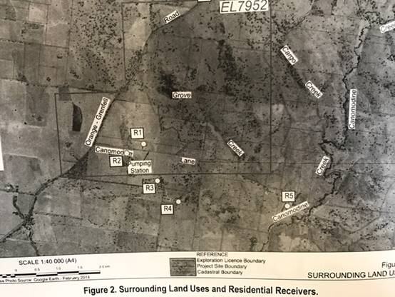
The proponent indicated that no air quality monitoring data is
available within or in the vicinity of the site, however as the area is rural
with no major pollution sources, the local air quality is unpolluted.
Dust emissions from the mine would be the principle source of air contamination
and would likely be associated with site preparation, road construction,
limestone extraction, wind erosion form exposed surfaces and stockpile sites,
movement of vehicles within unsealed sections of the mine site.
Management and mitigation measures are proposed to control air born
particles, including a commitment to maintaining stockpiles in a moist
condition using water carts and the application of water to all roads and
trafficked areas to minimize dust.
Surface water /Groundwater
Two unnamed watercourses occur within the site, one of which merges
to the immediate north of the mine site to Grove Creek, whilst the second
watercourse travels south before also merging with Grove Creek.
Grove Creek merges with Canomodine Creek approximately 2.5km south
east of the mine and the Belubula River approximately 3km away from the site.
The site is located within the Water Sharing Plan for the Belubula Regulated
River Water Source 2012. No water is to be extracted from the Belubula River
(located some 3km south of the proposed mine) as part of the development.
The subject land is within the Lachlan Fold Belt Murray –
Darling Basin fractured rock Groundwater Water Source area.
Operational water supply would be required for the development for
dust suppression and wetting of agricultural lime prior to stockpiling, also
for mine construction as well as wash down and road maintenance. The proponent
anticipated two water sources with a constructed sediment basin providing as
the primary source of operational water. The secondary operational water
source is proposed to be a production bore proposed to be constructed within
the vicinity of the proposed workshop and weighbridge.
A sediment basin is to be constructed within the extraction area to
capture all potentially sediment laden water from the mine area. This water
will be used for mining related purposes only. Clean water will be diverted
away from the mine area. A Surface Water Management Plan is to be implemented
to ensure segregation of clean water and sediment laden water.
The proponent initially proposed water supply from production bores
to provide sufficient capacity to meet the requirements of the mine. The
proposal has been amended so that the proposed bores be monitoring bores only.
Application for test and production bores will be subject to later and separate
application to DPI Water. Assuming a suitable groundwater resource is located,
the land owner and / or proponent would need to apply for a Water Access Licence
and need to purchase sufficient water allocation to ensure an adequate water
supply for the operational requirements of the proposed mine.
An identified alternate water source for the initial phase of
construction of the mine has been identified by the proponent as water trucked
to the site for on-site storage in tanks.??
The EIS notes that no groundwater dependent ecosystems are
registered within 35km of the site, however the Murray-Darling Basin Water
Sharing Plan lists the Canowindra and Canomodine Karst area as a high priority
karst environment groundwater dependent ecosystem. The proponent states that it
is not anticipated that the development will intersect groundwater or result in
aquifer interference, however it is noted that karst systems are typically have
a high degree of connectivity between surface and groundwater (due to fissures,
conduits or caves) which can rapidly disperse contaminates.
Given the likelihood that the karst system is situated above a
significant karst aquifer, and the high potential for transfer of contaminants
into the aquifer, te Office of Environment and Heritage have suggested that
ground water monitoring be required during the life of the mine (both quantity
and quality /level). DPI Water have issued GTA that address ground and surface
water issues. Conditions of development consent have been drafted based upon
DPI Water’s GTA and the recommendations of OEH.
The proponent provided the following anticipated water balance
requirements for the mine operation:
|
Source
|
Comment
|
Total (ML/yr)
|
|
Water Consumption
|
|
Dust suppression
|
Assumed water cart size = 16,000L
Allow 4 loads per day for summer months
(November to April)
Allow 2 loads per day for winter months
(May to October)
Allow 5.5 days per week
|
13.7
|
|
Product wetting
|
Allow 250,000tpa with an average moisture
content of 3%
|
7.5
|
|
Total consumption
|
21.3
|
An application for a minimum 22ML of groundwater for
‘industrial’ use is proposed to satisfy the project demands. The
likely scenario will be for groundwater to be pumped into a storage tank.
The hydrogeological assessment report accompanying the
proponent’s EIS establishes that the site has groundwater potential to
meet the project requirements, and that the necessary licences could be
obtained.
Potable water
Potable water is to be transported to the site in 20L tanks for
purposes of drinking. Water for ablutions is to be sourced from rain water
collection from rooves of the various site buildings, and stored in rainwater
tanks.
Management of waste
It is proposed to manage disposal of general waste materials
generated by the occupation of the site as follows:
|
Waste type
|
management
|
Disposal
|
|
General waste
|
Covered bins or skips
|
Collected on regular basis by waste contractor and
transported to a licensed waste disposal / recycling facility
|
|
General recyclables
|
As above
|
As above
|
|
Waste oils and greases
|
Placed in bunded tanks within workshop
area
|
Collected on a regular basis by waste contractor and
transported to a licensed facility for recycling
|
|
Batteries
|
Used batteries to be placed in a covered storage
area for site removal
|
Used batteries to be collected on a regular basis by
an appropriate contractor for recycling
|
|
Tyres
|
Used tyres would be placed in a marked storage area
for removal or used for another purpose
|
Collected on a regular basis by a licensed waste
contractor and transported to a licensed waste disposal facility
|
|
Scrap metal / steel
|
Stored in specific areas within workshop
or elsewhere as required
|
Collected on a regular basis by a scrap
metal recycler
|
|
Waste water
|
On site waste water treatment facility
with treated water used for irrigation of pasture within the project site
|
System to be approved by council
|
Site contamination
A concrete sealed refuelling area is to be provided. A bunded and
covered diesel and hydrocarbon store, incorporating an oil / water separator is
to be provided. All concrete sealed area are to drain to an oil / water
separator.
Site rehabilitation
A detailed Mining Operations Plan (MOP) is required to be prepared
prior to commencement of mining related activity upon the site. An Annual
Environmental Management Report and / or amended MOP will be produced by the
proponent throughout the life of the mine.
The proposed final landform for the site would include a free
draining revegetated open cut with a flat to gently sloping east sloping floor
and benches 7.5m high, a stick watering dam with stabilized spillway and all
other areas returned to pre-existing landform. The final land use would be
consistent with the existing land use, being agricultural activity –
grazing within a native vegetation community.
Socio economic benefit
The development is considered to have benefit to the local and
regional economy through employment and direct capital investment, and the
generation of up to 250,000 tonnes of lime product annually for us in
agriculture, construction and manufacturing industries.
THE SUITABILITY OF THE SITE s79C(1)(c)
Physical Attributes and Hazards
There are no known technological or natural hazards that would
affect the proposed development.
DEVELOPMENT CONTRIBUTIONS
No development contributions (s94 Environmental Planning &
Assessment Act) apply to the development. The proposed development is not
currently subject to the provisions of a Voluntary Planning Agreement under
s93F of the EP & A Act. A condition of consent requires that within six (6)
months of the date of the development consent, that the proponent enter into an
agreement with council for the annual payment of a monetary contribution to the
maintenance of local roads impacted by the additional heavy traffic generated
by the mine proceeding.
ANY SUBMISSIONS MADE IN ACCORDANCE WITH THE ACT s79C(1)(d)
The proposed development was advertised and neighbourhood
notified. Nine public submissions were
received by the close of the exhibition phase. One submission was
received from a public authority, and nine (9) submissions were received from
state agencies.
Issues raised in the public submission(s) are addressed as follows:
|
Issues
|
Comment
|
|
Submission 1
· Questions how the truck movements as outlined in
s2.5.2.1 of the EIS would be policed, ie trucks accessing Canomodine Lane
only from the Canowindra direction along Cargo Rd.
· Concerns regarding safety issues for local
landholders from increased traffic volumes – ability of farmers to
safely move livestock and farm equipment along Canomodine and Cargo roads.
· Requests Canomodine Lane be upgraded to the same
required standard as the proposed Cargo Road upgrade to accommodate B-double
truck traffic
· Are amenities such as toilets and rubbish bins
required to service the proposed truck stop
· Will existing rural mailboxes need to be relocated
from the end of Canomodine Lane and has consultation occurred with mail
service provider
· School bus stop must be located on the southern side
of Canomodine Lane for safety reasons Bus company and users should be
consulted in regard to location and length of proposed relocated bus stop(s).
· No mention of upgrades to other school bus stop
locations that exist along Cargo Road between Canomodine Lane and the Cudal
– Canowindra Rd intersection
· Questions is minor widening of road shoulders along
Cargo Road is going to be sufficient to address increased traffic use of the
road.
· Seeks information on the proposed truck route
through Canowindra.
· Concerned that neither the landowner or the
proponent had contacted them.
· In the event of a pollution incident affecting
downstream Grove Creek, what would be the likely contaminants.
· Concerned that 24hr per day grinding operation may
impact the amenity of the area
· Writer’s dwelling and ancillary buildings are
located less than 3km from the proposed mine and notes that should there be
impact from blasting at the mine they will be advising the proponent.
· Directly east of the site situated along Canomodine
Creek are multiple limestone caves that may have Aboriginal significance.
Concern that blasting may have adverse impact upon the caves.
|
Compliance with proponent’s Driver Code of
Conduct and internal regulation by the mine operator.
Noted
Conditions of consent apply
No
Noted – will be considered at
road upgrade / construction phase
Noted
Noted
Road construction standards apply
B-Double routes as authorized
Noted
Refer to EIS
Noted
Noted
Noted
|
|
Submission 2
· If mine proceeds suggests Cargo Road from Canomodine
Lane to Canowindra Rd up upgraded, as well as streets within Canowindra.
· Current school bus stops along Cargo Road are unsafe
now and must be reviewed as part of this development
· Existing private driveway access onto Cargo Rd is
already dangerous and danger will increase with the proposed truck traffic.
· Concerns that blasting will damage house foundations
|
Noted.
B-Double movements restricted to
authorized roads.
Noted
Review will occur as part of B-double
route application
Noted
|
|
Submission 3
· Primary concern is safety of children at the various
school bus stops located along Cargo Road.
· Concern over the current standard of Cargo Rd and
the potential impact of additional heavy traffic.
· Will an independent body test for compliance
with noise, air quality etc once the proposal is in operation and if
not what recourse will residents have should guidelines not be met.
|
Noted
Noted
Annual environmental report to be
prepared
|
|
Submission 4
· Considers existing school bus stop areas along Cargo
Rd from Canomodine Lane towards the Canowindra Rd are inadequate and that
either Westlime /RMS /council should upgrade bus pull off / pick areas to
enable a bus to entirely pull off the roadway.
· The section of road from the Canowindra Rd
intersection to the first hill (Adams Hill) is atrocious
· Writers private driveway access off Cargo Rd is
unsafe and will become more of a risk with additional heavy traffic using
Cargo Rd.
· Questions potential for noise impact from blasting
and processing operations given the writer can hear the Cadia Mine operation
during night hours.
· Questions species selection of revegetation strategy
and suggests a greater emphasis on replanting White Box Grassy Woodland
species.
· Supports the mine going ahead subject to road issues
and bus stop safety being adequately addressed.
|
Noted
Noted
Will be reviewed as part of B-Double
route application
Subject to environmental controls and EPL
OEH recommendations included as
conditions of consent
Noted
|
|
Submission 5
· Supports development however seeks information as to
whether trucks will be using Rodd Street, Canowindra
|
Rodd St is an existing authorized
B-double route
|
|
Submission 6
· EIS does not take into account LLS issued permits
for movement of livestock along Canomodine Lane and Cargo Rd. Stock movement
will continue and will require exclusive use of the road system for several
hours at a time.
· Increased traffic by the mine proceeding will create
safety concerns for residents of the area and general nuisance. A reduction
in heavy vehicle traffic movements and the times they are permissible is
desirable.
· Notes proposal to relocate bus stops(s). Requests
input be sought from RMS and Hassad Australia to ensure safe locations are
chosen
· Does not support location the road intersection at
the crest of a hill due to limited sight vision and reaction time by road
users along Cargo Road.
· Development will create permanent significant disturbance
to neighbour and their livestock by way of traffic and operational noise,
dust and vibration.
· Noting a likelihood medium risk of fly rock being
ejected from the site outside the blast zone.
· Grinding plant operating 24 hours per day will have
a constant sound and impact upon an otherwise rural area.
· Requests baseline water sampling be undertaken
before works commence and seeks assurance of recourse should water
contamination of the groundwater or creeks occur. Similar requirements are
sought to address air quality. Seeks a report on potential contaminants that
could flow into Grove Creek or could seep into groundwater.
|
Proponent acknowledges stock permits
Noted
Noted
Conditions of consent apply to road
upgrade and design
Noted
Noted
Noted
Ground water monitoring is to be undertaken.
EIS addresses potential for contamination of
groundwater and mitigation controls to ensure contamination risk is minimal
|
|
Submission 7
· Objects to the DA based upon the area also being
subject to an Exploration License held by Sams Reed in respect to Group 1
Minerals. Concerns that the notification of the proposal did not identify
that the proposal requires a Mining Lease. States lack of cooperation from
Westlime to engage with Sams Reef
|
Noted
|
|
Submission 8
· Objection to location of proposed mine immediately
adjacent to neighbouring land.
· Concerns regarding dust generated from the mine and
adverse impact of dust drifting onto adjoining pasture land.
· The site is to be inundated by the proposed Cranky
Rock Dam.
· There is a line of caves that runs under the
proposed mine site. The caves have only been partially explored. Within the
vicinity Grove Creek disappears underground only to reappear downstream. The
ground sounds hollow and areas have caved in. Micro bats can be observed
flying out at dusk.
· The limestone hosts a rare Applebox Woodland that is
being impacted by mistletoe.
· Large marsupials are common on the site, namely Rock
Wallabies, Wallaroo and Grey Kangaroos.
· The valley, and the surrounding area have high
visual amenity due to the rugged landscape and the rural environment.
· A geologist has stated that the particular local
limestone has a high silica content and is unsuitable for agricultural lime.
Quartz seams run through the limestone formations.
· There are already two limestone quarries in the
Cabonne area.
|
Noted
Environmental controls apply
Noted
Noted
Noted
Noted
Noted
Noted
Noted
|
|
Submission 9
· Questions the validity of traffic surveys undertaken
during the month of July, as the writer believes that to be a quiet time of
year and not representative of actual traffic volumes. Existing roads are not
of a standard to accommodate the additional heavy vehicle traffic.
· Cites Canowindra Chamber of Commerce press
statements that the future of the area is tourism, and comments that a mine
would be counterproductive to tourism promotion. Increase of heavy traffic on
country roads will be up to a 48% increase in traffic.
· A significant community of Superb Parrots
(threatened species) is recorded within 2km of the proposed mine site.
Migratory birds use the valley corridor.
· EIS notes present of regent honey eaters. The writer
brings to council’s attention that the species is critically
endangered.
· A well-established wedge tail eagle nest is located
within line of sight of the mine. The presence of the mine will impact upon
the habitat
· The presence of birds in the area and upon the site
has been underestimated in the EIS.
· EIS mentions impact of noise and dust from the mine
and the crusher. No mention of light spillage and potential impact upon the
area.
|
Noted
Noted
Noted
Noted
Noted
Noted
Noted. Addressed by condition of consent
|
Each of the issues in objection to the proposal has been addressed
via conditions of consent, as such the development application can be
authorised under delegated authority without being referred to the
Environmental Services and Sustainability Committee.
NOTIFICATION TO PUBLIC AUTHORITIES
The application is integrated development and was referred to the
RMS, EPA, OEH, DPI Water, Resource and Energy, Trade & Investment and
Central Tablelands Water for comment and terms of approval.
|
Agency
|
Comment
|
|
Central Tablelands Water
|
CTW has infrastructure within close
proximity of the proposed mine. A trunk main passes through part of the
subject land, and a Water Pump Station is located to the west of the proposed
development. CTW request it be noted that under the NSW Local Government Act
1993 it is an offence to damage CTW infrastructure.
|
|
EPA
|
The proponent should be required to
prepare an Erosion and Sediment Control Plan prior to site establishment and
construction activities.
While noting that a Mining Operations
Plan will be required prior commencement of mining operations, EPS is
concerned that progressive rehabilitation procedures have not been addressed.
Concerns relating to the 24 hr daily operation of the grinding activities
however will accept the activity provided the proponent ensures noise does
not exceed the relevant criteria.
The proponent will be required to manage
air quality to ensure management and mitigation measures proposed in the EIS
are complied with.
|
|
DPI Water
|
With the removal of the production bores
there is no confirmed water supply to the project. It is recommended that a
reliable water supply be confirmed and any potential impacts in assessing
this supply be identified prior to determining the application.
DPI Water supports installation of
monitoring bores MB1 and MB2 and collection of base line data prior to
commencement of site excavation.
DPI Water is satisfied that no
assessment against the NSW Aquifer Interference Policy is required. However,
if groundwater is intercepted during excavation the proponent will be
required to contact DPI Water to confirm approvals required.
The proposed clean water diversion will
be a key component of the environmental management at the site. Ensuring its
stability through the site and conveyance of water in a stable manner into
the downstream watercourse will need to be addressed in the detailed design,
construction and operation of the project. DPI Water recommends the works be
carried out consistently with industry guidelines such as the ‘Managing
Urban Stormwater – Soils and Construction – Mines and Quarries
(DECC 2008)’ and the ‘Guidelines for controlled activities on
waterfront land (DPI 2012)’
It is recommended that a condition of
consent be included for the development of a Soils and Water Management Plan
in consultation with DPI Water to address the following key issues at the
site – erosion and sediment control, water supply and distribution,
groundwater monitoring and management, surface water monitoring an
management.
|
|
NSW Dept of Industry – Division of
Resources and Energy – Royalties and Advisory Services
|
The EIS fundamentally addresses the
Division’s Adequacy Review comments. The EIS has identified general
rehabilitation strategies and objectives. The functional domains of the project
have been adequately described and performance objectives and standards
satisfactorily described.
|
|
RMS
|
Reviewed EIS and Response to Submissions
and grants its concurrence to the upgrade of Canomodine Lane and Cargo Road
(MR237) subject to conditions.
RMS will require construction of a basic
right turn treatment is to be provided to Cargo Road at its intersection with
Canomodine Lane. The widened road shoulder is to be sealed and built for a
100km/hr speed environment to provide a reasonable level of safety for
traffic turning right into Canomodine Lane and to allow following traffic to
pass on the left hand side.
A basic left turn treatment is to be
provided in Cargo Road at its intersection with Canomodine Lane. This
facility will need to be sealed and built for a 100km/hr speed environment.
The intersection is to be designed to accommodate the turning path of the
largest vehicle required to access the mine.
The proposed school bus bay adjoining the
Cargo Road northbound travel lane is to be located on the departure side of
the intersection and not as shown in the proposed plans as being located on
the approach side.
Safe Intersection Sight Distance
requirements outlined in Part 4A ‘Austroads Guide to Road Design’
and relevant RMS supplements are to be provided and maintained in both
directions at the intersection of Cargo Road and Canomodine Lane.
All activities including loading and
unloading of goods associated with the development are to be carried out
onsite, and all loads are to be adequately covered before vehicles exit the
site.
Haulage operations on Cargo Road and
Canomodine Lane coinciding with local student school bus pick up/drop off
times are to be avoided.
The proponent will be required to prepare
and implement a driver code of conduct for the task of transporting materials
on public roads.
|
|
EOH
|
Reviewed EIS and RTS - The RTS does not address all of the concerns raised
by OEH. Specifically, OEH is
not
satisfied that the proposed offset strategy adequately offsets the proposed
impacts to Box Gum
Woodland Endangered Ecological Community and
recommends conditions of consent be applied including a requirement to
increase the offset area to 55ha
|
|
Water NSW
|
At request of a landowner, advising
council of possible impact to the subject site should the Cranky Rock dam
proposal proceed.
|
Internal Referrals
Building assessment
Separate applications will be required to assess all structures
proposed for construction upon the mine site (with exception of any structure
that satisfies exempt development provisions.
Separate application will be required for the waste water treatment
on on-site sewage system.
Engineering assessment
Council’s Development Engineer has reviewed the EIS and RTS
and the agency GTA and supports RMS conditions of development consent relating
to Cargo Road (MR237) subject to an additional requirement being that a
roadworks construction certificate be obtained prior to any road works
commencing.
The proponent proposes an upgrade to approximately 1.8km of
Canomodine Lane from its intersection with Cargo Road to the access point of
the mine, with an 8m seal on a 10m formation with some road re-alignment from
the existing gravel road formation. Council would prefer that the seal be
increased to 10m on a 10m formation to eliminate risk of road shoulders
deteriorating. A condition of consent addresses this requirement.
PUBLIC INTEREST s79C(1)(e)
The proposed development is considered to be within the public
interest as it provides employment both directly and indirectly. There is a
relatively localised nature of potential impacts.
CONCLUSION
The proposed development is permissible with the consent of council.
The development complies with the relevant aims, objectives and provisions of
the LEP. A section 79C assessment of the development indicates that the
development is acceptable in this instance. Attached is a draft Notice of
Approval outlining a range of conditions considered appropriate to ensure that
the development proceeds in an acceptable manner.
ITEM 24 - DEVELOPMENT
APPLICATION 2017/0031 FOUR LOT RURAL SUBDIVISION OF LOTS 35 & 47 DP 750389
AND LOTS 102 & 103 IN DP 1005154, 521 GOWAN ROAD, GOWAN
REPORT IN BRIEF
|
Reason For Report
|
To obtain
council's determination of the development application 2017/0031
|
|
Policy
Implications
|
Nil
|
|
Budget
Implications
|
Nil
|
|
IPR Linkage
|
4.5.3.a -
Assess and determine development applications, construction certificate
applications and Onsite Sewerage Management Systems (OSMS) to meet agreed
service levels
|
|
Annexures
|
1. Conditions of Consent⇩
|
|
File Number
|
\Development
Applications\DEVELOPMENT APPLICATION\2017\03-2017-0031 - 797940
|
|
Recommendation
THAT Development Application 2017/0031 for a four lot rural subdivision
of land described as Lots 35 & 47 in DP 750389 and Lots 102 & 103 in
DP 1005154, known as 521 Gowan Road, Gowan, be granted consent subject to the
conditions attached.
|
Director of Environmental Services' REPORT
|
ADVISORY NOTES
Record of voting
In accordance with s375A of the Local Government Act 1993, a
division is required to be called when a motion for a planning decision is
put at a meeting of Council or a Council Committee. A division under
s375A of the Act is required when determining this planning application.
Political Disclosures
In accordance with s147(4) of the Environmental Planning and
Assessment Act 1979, a person making a planning application to Council is
required to disclose political donations and gifts made within 2 years prior
to the submission of the application and concluding when the application is
determined.
In accordance with s147(5) of the Environmental Planning and
Assessment Act 1979, a person making a public submission to Council in
relation to a planning application made to Council is required to disclose
political donations and gifts made within 2 years prior to the submission
being made and concluding when the application is determined.
Political donations and gifts (if any) to be disclosed include:
· All reportable political donations made to any local councillor or
Council,
· All gifts made to any local councillor or employee of the Council.
Nil planning application disclosures have been received.
Nil public submission disclosures have been received.
|
SUMMARY
The following report provides an assessment of the development
application submitted for subdivision of land described as Lots 35 and 47 DP
750389, Lots 102 and 103 DP 1005154, being 521 Gowan Road, Gowan.
The application has been referred to council for determination as
the application was neighbour notified for a period of 14 days as per council
policy on subdivision notification with 3 submissions
being received during the exhibition phase.
It is recommended that the application be approved subject to
conditions of consent.
Applicant: Fred
Jeloudev c/- Geolyse
Owner: Fred
Jeloudev
Proposal: Four
(4) lot subdivision
Location: Lots
35 and 47 DP 750389, Lots 102 and 103 DP 1005154, 521 Gowan Road, Gowan
Zone:
RU1 Primary Production
Section 23A of the Local Government Act “Council decision
making during merger proposal periods” requires Council to consider these
guidelines and assess any impact upon a determination. The guidelines have been
considered and the proposed development and determination for approval is not
contrary to the guidelines.
THE PROPOSAL
It is proposed to seek consent for subdivision of the land to create
four (4) allotments:
|
Proposed
Lot
|
Area
(ha)
|
Purpose
|
|
Lot 1
|
147.7
|
Primary
Production
|
|
Lot 2
|
107.3
|
Primary
Production
|
|
Lot 3
|
493.2
|
Primary
Production with an existing dwelling
|
|
Lot 4
|
101.6
|
Primary
Production
|
|
TOTAL
|
849.8ha
|
|
Building envelopes have been nominated for proposed Lots 1, 2 and 4
to take advantage of cleared areas to minimize disturbance to the area and
limit vegetation clearing. As assessment has been provided of the Asset
Protection Zones (APZ) required for future dwellings. The nominated building
envelopes are sited such that the APZ may be implemented with minimal
additional land clearing of native vegetation.
The proposed lots will access Gowan Road access locations for Lots
1, 2 and 3 making use of existing gateways. An additional access way will be
required to service proposed Lot 4. Part of the existing Gowan Road formation
is situated within the subject land and outside the road reservation.
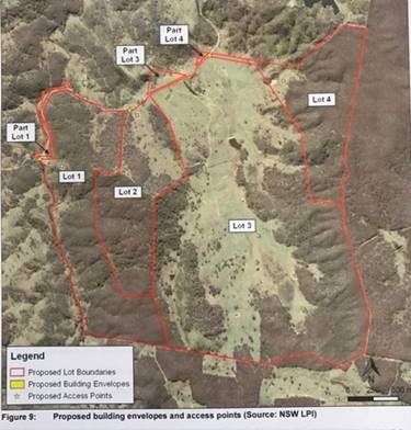
Site
The site is located on the eastern side of Gowan Road some 22km
north east of Orange. The area is characterized by largely undisturbed land
containing stands of native timber. Agriculture in the area is generally
limited to livestock grazing. The property currently is divided
into large paddocks for the purpose of grazing.
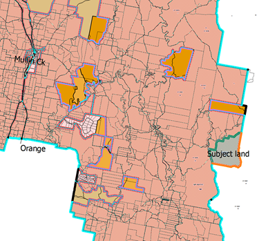
Site map
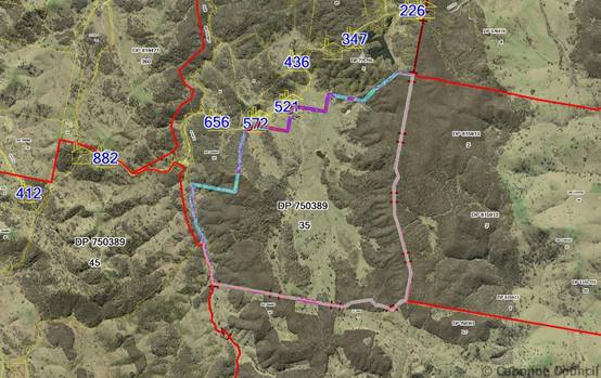 Aerial map of subject land
MATTERS FOR CONSIDERATION
Section 79C of the Environmental Planning and Assessment Act 1979
requires Council to consider various matters, of which those pertaining to the
application are listed below.
PROVISIONS OF ANY ENVIRONMENTAL PLANNING INSTRUMENT s79C(1)(a)(i)
Clause 1.2 Aims of the Plan
The broad aims of the LEP are as follows:
a) to encourage
development that complements and enhances the unique character and amenity of
Cabonne, including its settlements, localities, and rural areas,
(b) to provide
for a range of development opportunities that contribute to the social,
economic and environmental resources of Cabonne in a manner that allows present
and future generations to meet their needs by implementing the principles of
ecologically sustainable development,
(c) to
facilitate and encourage sustainable growth and development that achieves the
following:
(i) contributes to continued economic productivity, including
agriculture, business, tourism, industry and other employment opportunities,
(ii) allows for the orderly growth of land uses while minimising
conflict between land uses within the relevant zone and land uses within
adjoining zones,
(iii) encourages a range of housing choices and densities in planned
urban and rural locations that is compatible with the residential and rural
environment and meets the diverse needs of the community,
(iv) promotes the integration of land uses and transport to improve
access and reduce dependence on private vehicles and travel demand,
(v) protects, enhances and conserves agricultural land and the
contributions that agriculture makes to the regional economy,
(vi) avoids or minimises adverse impacts on drinking water
catchments to protect and enhance water availability and safety for human
consumption,
(vii) protects and enhances places and buildings of environmental,
archaeological, cultural or heritage significance, including Aboriginal relics
and places,
(viii) protects and enhances environmentally sensitive areas,
ecological systems, and areas that have the potential to contribute to improved
environmental, scenic or landscape outcomes.
Clause 1.9A Suspension of covenants,
agreements and instruments
This clause
provided that covenants, agreements or other similar instruments that restrict
the carrying out of development upon the subject land do not apply unless such
are:
· Covenants imposed or required by council
· Prescribed instruments under s183A of Crown Lands Act 1989
· Any conservation agreement under National Parks and Wildlife Act
1974
· Any trust agreement under the Nature Conservation Trust Act 2003
· Any property vegetation plan under the Native Vegetation Act 2003
· Any biobanking agreement under Part 7A of the Threatened Species
Conservation Act 1995
· Any planning agreement made under Division 6 of Part 4 of the
Environmental Planning & Assessment Act 1979
Mapping
The subject site is identified on the LEP
maps in the following manner:
|
Land zoning map
|
Land zoned RU1 Primary Production
|
|
Lot size map
|
Minimum lot size 100ha
|
|
Heritage map
|
Not a heritage item or conservation area
|
|
Terrestrial Biodiversity Map
|
Has
biodiversity sensitivity on the subject land (Stringy bark – Box
– Gum Woodland, wetlands vegetation and Red Stringybark –
Blakely’s Red Gum – Yellow Box Woodland)
|
|
Flood planning map
|
Not within a flood zone
|
|
Natural resource – karst map
|
Not within a karst area
|
|
Drinking water catchment map
|
Not within a drinking water catchment area
|
|
Riparian land and watercourse map, groundwater
vulnerability map
|
Riparian land - watercourses
|
|
Land reservation acquisition map
|
|
These matters are addressed in the report following.
Cabonne Local Environmental Plan 2012
The subject land is zoned RU1 Primary Production by the Cabonne
Local Environmental Plan 2012. Subdivision of land is permissible within
this zone, subject to Council’s development consent.
Objectives of the
RU1 Primary Production zone
The proposal is not contrary to the aims of
the LEP or the objectives of the RU1 zone. The development relates to and
is consistent with the zone objectives which seek to
· To encourage sustainable primary industry production by maintaining
and enhancing the natural resource base.
· To encourage diversity in primary industry enterprises and systems
appropriate for the area.
· To minimise the fragmentation and alienation of resource lands.
· To minimise conflict between land uses within this zone and land
uses within adjoining zones.
· To enable function centres, restaurants or cafes and appropriate
forms of tourist and visitor accommodation to be developed in conjunction with
agricultural uses.
Part 2 – Permitted or prohibited development
The proposed development for subdivision is a permissible land use
in the RU1 zone subject to development consent.
Part 4 – Principal development Standards
Clause 4.1 Minimum subdivision lot size
The subject land requires a MLS of 100 hectare for each lot created
for land zoned RU1 Primary Production. The proposal meets the development
standard for minimum lot size with proposed Lots 1, 2 and 4 having an area of
at least a 100ha each and proposed Lot 3 having an area of 493ha with an
existing dwelling.
Part 6 – Additional local provisions
Clause 6.3 Terrestrial biodiversity
The
objective of this clause is to maintain terrestrial biodiversity by:
(a) protecting native fauna and flora, and
(b) protecting the ecological processes
necessary for their continued existence, and
(c) encouraging the conservation and recovery of
native fauna and flora and their habitats.
The site is partially affected by Terrestrial Biodiversity as per
the Terrestrial Biodiversity Map and is covered predominantly with Stringybark
– Box – Gum Woodland. Several areas of wetlands vegetation are
mapped within the property as well as Red Stringybark - Blakely's Red Gum -
Yellow Box woodland. While some land clearing has occurred the ridges
have been conserved. The land has been modified from its natural state and has
been used for agricultural purposes for the last century.
Local information suggests that the property has previously been a
private conservation area, and that koala populations are known to be in the
vicinity. The OEH BioNet Atlas of NSW Wildlife records koala in the vicinity of
the Gowan Road property, although no sightings are recorded for the subject
land.
All regrowth on land identified by NSW Office of Environment and
Heritage as Vulnerable Land is protected by the Native Vegetation Act 2003. The
OEH mapping of Vulnerable Land – Steep or Highly Erodible identifies land
within the subject area as having a gradient of 18 degree or more. As no
clearing is required to facilitate the subdivision as proposed boundaries will
generally utilize existing paddock fence lines there will be minimal impact
upon the terrestrial biodiversity of the property.
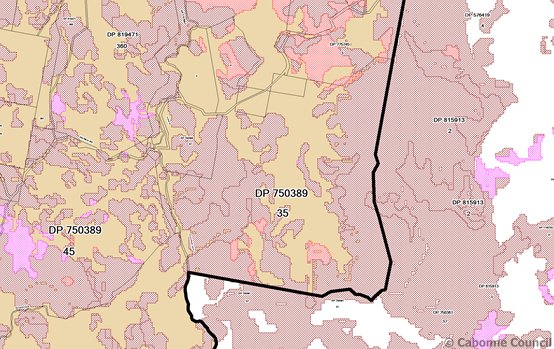
Clause 6.6 Riparian land and watercourses
The
objective of this clause is to protect and maintain the following:
(a) water quality within watercourses,
(b) the stability of the bed and banks of
watercourses,
(c) aquatic and riparian habitats,
(d) ecological processes within watercourses and
riparian areas.
The subject land is identified as “Watercourse” on the
Riparian Lands and Watercourses Map. Coolumbala Creek and Lucky Swamp Creek
traverse the property. The proposed development for subdivision is not contrary
to the objectives of the clause. The development is unlikely to have an adverse
impact upon the water flows; any aquatic or riparian species, habitats or
ecosystems; stability of the bed or banks of the watercourse; or impact upon
any future rehabilitation of the watercourse or riparian area.
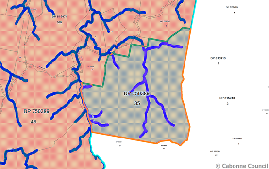
Clause 6.8 Essential services
Development
consent must not be granted to development unless the consent authority is
satisfied that any of the following services that are essential for the
development are available or that adequate arrangements have been made to make
them available when required:
(a) the supply of water,
(b) the supply of electricity,
(c) the disposal and management of sewage,
(d) stormwater drainage or on-site conservation,
(e) suitable vehicular access.
Electricity and telecommunication facilities are available within
the locality. Any upgrades are at the expense of the developer to meet the
necessary requirements for the relevant authority.
The site is not connected to reticulated sewer or water and as such
the provision of onsite facilities will be required at the dwelling stage
should an application ever be received for the vacant agricultural land.
The existing dwelling on proposed Lot 3 is currently serviced by
on-site provisions for water and sewer, and connected to electricity and
telecommunications.
Access is proposed via Gowan Road and as such, the proposal meets
the requirement for adequate provision of essential services.
REGIONAL ENVIRONMENTAL PLANS
There are no Regional Environmental Plans that apply to the subject
land.
STATE ENVIRONMENTAL PLANNING POLICIES
State Environmental Planning Policy No.44 (Koala Habitat) applies to the land. Cabonne Council is identified within the SEPP
44 schedule as having koala habitat. Koala colonies are known to be in
the Gowan area with sightings recorded at the nearby Freemantle Nature Reserve
and isolated reports of koala on private properties within the vicinity of the
subject land.
The subdivision of the property does not require clearing of timber.
Existing fence lines will generally be used to define the boundaries of the
proposed allotments. The subdivision of the property is unlikely to impact upon
the habitat or potential habitat of koala.
State Environmental Planning Policy 2008 (Rural Lands) applies to the subject land.
8 Rural Subdivision
Principles
The Rural Subdivision Principles are as follows:
(a) the
minimisation of rural land fragmentation,
The existing land consists of four (4) land titles with the holding
predominantly held within Lot 35 and having an area alone of 748.9ha. The
proposal whilst retaining the same numerical allotments will fragment the
holding as far as potential ownership patterns and sustainability of extensive
agriculture.
(b) the minimisation of rural land use conflicts, particularly
between residential land uses and other rural land uses,
Agricultural land surrounds the subject land. While small scale
agricultural practice can continue on each of the proposed allotments the
development has the potential for additional dwellings and diversification of
land use and lifestyle opportunities. Conflict of land uses is considered
to be minimal.
(c) the consideration of the nature of existing agricultural
holdings and the existing and planned future supply of rural residential land
when considering lot sizes for rural lands,
The subdivision will result in the fragmentation of an existing
858ha holding into four holdings having areas of 10101.6ha, 107.3ha, 147.7ha
and 493.2ha. The lot sizes satisfy the minimum lot size for rural land where a
dwelling may be permissible.
(d) the consideration of the natural and physical constraints and
opportunities of land,
The land is identified as Class 5 land by the NSW Agriculture Land
Classification. Class 5 land is typically steep country with poorer soil
profiles and suitable for grazing land. The overall production level is low
because of environmental constraints. The land has a history of use for
agricultural production, mainly grazing
(e) ensuring that planning for dwelling opportunities takes account
of those constraints.
Building envelopes have been nominated for proposed Lots 1, 2 and 4
taking into account existing native vegetation and bush fore risk.
10 Matters
to be considered in determining development applications for rural subdivisions
or rural dwellings
(1) This clause
applies to land in a rural zone, a rural residential zone or an environment
protection zone.
The subject land is zoned RU1 Primary Production.
(2) A consent authority must take into account the matters specified
in subclause (3) when considering whether to grant consent to development on
land to which this clause applies for any of the following purposes:
(a) subdivision of land proposed to be used for the purposes of a
dwelling,
(b) erection of a dwelling.
The application is for subdivision. A dwelling exists upon proposed
Lot 3. Proposed Lots 1, 2 and 4 have areas of 100ha or greater and a dwelling
may be a permissible land. A further application will be required for any
dwelling on the agricultural holdings and these applications would be subject
to the planning provisions applicable at the time of application.
(3) The following matters are to be taken into account:
(a) the existing uses and approved uses of land in the vicinity of
the development,
The land currently contains an existing dwelling with the remainder
of the land being used for agricultural production. Surrounding land use is
agriculture with associated dwellings.
(b)whether or not the development is likely to have a significant
impact on land uses that, in the opinion of the consent authority, are likely
to be preferred and the predominant land uses in the vicinity of the
development,
Agricultural use of the subject land is likely to continue.
(c) whether or not the development is likely to be incompatible with
a use referred to in paragraph (a) or (b),
This site is zoned RU1 Primary Production with the current use and
future use of the land for continued agricultural production.
(d) if the land is not situated within a rural residential zone,
whether or not the development is likely to be incompatible with a use on land
within an adjoining rural residential zone,
The land is current zoned RU1 Primary Production and all surrounding
land is for agricultural production.
(e) any measures proposed by the applicant to avoid or minimise any
incompatibility referred to in paragraph (c) or (d).
No measures have been proposed by the applicant to address any
incompatibility of adjoining land uses.
The proposal is generally consistent with the provisions of the
SEPP.
State Environmental Planning Policy 55 – Remediation of land applies to the subject land. The land has historically been
used for agriculture. A desk top search has not indicated evidence of a
shearing shed or such farm infrastructure that may be associated with
contaminated land. A small section of proposed Lot 1 was used as gravel quarry.
The site has been remediated by Cabonne Council and its care and control
reverted to the land owner.
PROVISIONS OF ANY DRAFT ENVIRONMENTAL PLANNING INSTRUMENT THAT HAS
BEEN PLACED ON EXHIBITION s79C(1)(a)(ii)
There are no draft environmental plans that
relate to the subject land or proposed development.
PROVISIONS OF ANY DEVELOPMENT CONTROL PLAN s79C(1)(a)(iii)
Development Control Plan No 5 – General Rural Zones applies to
this development. Section 2 of the DCP applies to subdivision of rural land.
The SoEE submitted by the proponent adequately addresses the DCP
requirements. The proposed development is generally consistent with the
provisions of the plan.
PROVISIONS PRESCRIBED BY THE REGULATIONS s79C(1)(a)(iv)
The proposal does not contravene the relevant provisions
of the regulations.
THE LIKELY IMPACTS OF THE DEVELOPMENT s79C(1)(b)
Lot size and shape
The proposed development is for the subdivision of a rural holding
into four (4) lots being agricultural land having areas of at least 100ha each
and proposed Lot 3 containing an existing dwelling and having an area of
approximately 493.2ha.
The boundaries proposed for the development are irregular however
follow existing fence lines and land form.
Visual amenity
The proposed subdivision will not involve any
land clearing, works or structures that would adversely affect the quality of
the existing landscape.
Access and traffic
Access to proposed Lots 1, 2 and 4 will require access points to be
either upgraded or constructed. Proposed Lot 3 has an existing access point
that complies with council’s current specification.
Increase in traffic generation from the subdivision proceeding is
considered to be capable of accommodation within the existing road network. Section
94 road upgrade contributions apply to the development.
THE SUITABILITY OF THE SITE s79C(1)(c)
Physical Attributes and Hazards
The land is mapped as bushfire prone. The development application
was submitted to NSW Rural Fire Service as integrated development and a section
100B authority subsequently was issued. The RFS requirements are incorporated
in the attached draft notice of consent.

DEVELOPMENT CONTRIBUTIONS
Section 94 Road Contributions are applicable to this development.
The s94 road contribution is calculated at $157,511.62, however the reforms to
the Local Development Contributions Circular issued by the Department of
Planning (PS10-022) has resulted in a $20,000 capped contribution rate applying
from 16 September 2010. Therefore, the proposed development incurs a maximum
section 94 contribution of $16,413.50.
Council’s Bushfire Services Contributions Plan applies to the
development. A contribution of $3,586.50 to The Ponds Brigade applies.
Conditions of consent has been included in the attached draft notice
of consent.
ANY SUBMISSIONS MADE IN ACCORDANCE WITH THE ACT s79C(1)(d)
The proposed development is not advertised development however; the
proposed development was neighbour notified for a period of 14 days with three
(3) submissions being received during the
exhibition phase. The submissions are summarized as follows:
|
Submission
|
Comment
|
|
Submission 1
Objects to the proposal based on
increased traffic and current standard of Gowan Road. Should the road be
sealed from Lewis Ponds Creek to proposed Lot 3 and/or the road be upgraded
the objection would be withdrawn.
|
The development has been assessed by
council’s Development Engineer and conditions of consent included
requiring upgrade of access to the lots, also s94 contributions for Gowan
Road upgrade.
|
|
Submission 2
Is the rezoning to be rural or rural
residential?
Gowan Road is narrow, winding and dusty.
How will council address traffic?
Cumulative impact of development along
Gowan Road with other approvals issued for subdivision of land.
Suggests one access point to service all
4 lots
Has an environmental study been
undertaken?
Is the site still a wildlife refuge?
Will council make the current and any new
owners aware of their responsibility for west and pest animal issues?
Is the quarry still operational and what
will happen to rehabilitation of the quarry? Will it be reopened?
What consideration has been given to near
neighbours and impact of future buildings
The subdivision will impact upon the
virtually uninterrupted views from the writer’s property.
|
The land isn’t proposed for
rezoning. The development is a 4 lot subdivision of rural land.
Council’s Development Engineer has
provided an assessment of road and traffic impacts.
Three lots will gain access from existing
gateways. A 4th lot will require anew access.
A Statement of Environmental Effects was
submitted with the DA.
The subject land is not a gazette
Wildlife Reserve.
The DA was referred to council’s
weeds officer. There are no current outstanding notices for the property.
The quarry ceased operation and the site
remediated and returned to the land owner’s care.
Building envelopes have been identified
as part of the DA.
The subdivision will have no impact upon
views. Further development of the allotments will be subject to merit based
assessment of applications.
|
|
Submission 3
Queries the location of the common
boundary between the subject land, Lucky Creek and land to the west,
north/west
Understood that Gowan Road is a ROW.
Inferior condition of Gowan Road results
in dust problems and reduces driver visibility. The road is increasingly
being used by recreation 4wd traffic. Recommends dust suppression material be
laid near or in front of existing residences in proximity to the development.
Has traffic generation from the 3 new
lots been considered?
Previous owner of the subject land
indicated that a koala colony exists near the rear of proposed Lot 1.
|
The property will be subject to survey by
a registered surveyor.
Gowan Road is constructed generally
within the road reserve. A section of the formed road is outside the reserve.
This matter is addressed by a condition of consent.
Section 94 road contributions apply to
the development.
Yes
Noted
|
Public authority consultation
The development was referred to the NSW RFS and a s100B authority
issued.
As a result of an enquiry by a nearby resident to the development,
council was contacted by a ranger from NP & WS to advice it of the recorded
sightings of koalas in the area, including the Freemantle Nature Reserve. The
ranger confirmed that the property is not a gazetted Wildlife Refuge.
PUBLIC INTEREST s79C(1)(e)
The proposed development is considered to be of minor interest to
the wider public due to the relatively localised nature of potential
impacts.
CONCLUSION
The proposed development permissible with the consent of council. A
section 79C assessment of the development indicates that the development is
acceptable in this instance. Attached is a draft Notice of Approval
outlining a range of conditions considered appropriate to ensure that the development
proceeds in an acceptable manner.
Section 23A of the Local Government Act “Council decision
making during merger proposal periods” requires council to consider these
guidelines and assess any impact upon a determination. The guidelines have been
considered and the proposed development and determination for approval is not
contrary to the guidelines.
ITEM 25 - PLANNING PROPOSAL -
REZONING OF FORMER CWA HALL, HILL STREET, MOLONG AND INCLUSION OF RURAL
BOUNDARY ADJUSTMENT CLAUSE TO CABONNE LEP 2012.
REPORT IN BRIEF
|
Reason For Report
|
To obtain
council authorisation to make the amending LEP plan
|
|
Policy Implications
|
Nil
|
|
Budget Implications
|
Nil
|
|
IPR Linkage
|
4.5.3.a - Assess and determine
development applications, construction certificate applications and Onsite
Sewerage Management Systems (OSMS) to meet agreed service levels
|
|
Annexures
|
Nil
|
|
File Number
|
\OFFICIAL
RECORDS LIBRARY\LAND USE AND PLANNING\PLANNING\AMENDMENT 5 TO LEP 2012
– CWA HALL MOLONG AND RURAL BOUNDARY ADJUSTMENT CLAUSE - 794601
|
|
Recommendation
THAT pursuant
to section 59 of the Environmental Planning & Assessment Act 1979,
council forward the Planning Proposal to the Department of Planning and
Infrastructure for the Minister to make a Local Environmental Plan to:
1. rezone Lot 272 DP 750170 and an adjoining road
reserve, Hill Street, Molong from R1 General Residential to B2 Local Centre,
and
2. include an additional clause
into the Cabonne LEP 2012 to address boundary adjustments upon rural land
where such land is less than the minimum lot size.
|
Director of Environmental Services' REPORT
Council at its meeting of 28 June
2016 resolved to prepare a Planning Proposal for
submission to the Department of Planning & Environment to:
1. rezone the former CWA Hall land and adjacent road
reserve located in Hill Street, Molong from R1 General Residential to B2 Local
Centre, and
2. include an additional clause into the Cabonne Local
Environmental Plan 2012 to address boundary adjustments upon rural land where
such land is less than the minimum lot size.
The Planning Proposal was
subsequently drafted and the proposal was forwarded to the department on 15
August 2016. A Gateway Determination was issued by the department on 15
September 2016. The Gateway Determination
required consultation with NSW Rural Fire Service, who reviewed the Planning
Proposal and had no objection to the rezoning proceeding or the inclusion of
the additional LEP clause.
The Planning Proposal was
referred to the RFS on 19 September 2016, with their concurrence provided on 10
October 2016. The Department of Planning & Environment issued its approval
on 25 October 2016 for the exhibition of the proposal to proceed.
The plan placed upon public
exhibition for a period of 28 days commencing Monday 31 October 2016 and
concluding on Friday 25 November 2016. During the exhibition period the
Planning Proposal and all relevant documents were publically available at the
council’s Molong, Cudal and Canowindra, as well as via council’s
web site. Notification was made through public advertisement placed in the
Central Western Daily newspaper, Molong Express, Forbes Advocate, the
Canowindra press, as well as the community newspapers and newsletters.
Written notification was provided
to adjacent and nearby landowners of the Hill Street land at Molong.
By the close of the exhibition
period one submission had been received by council. The submission received
from the NSW Roads & Maritime Services requested that consideration be
given to traffic impact generated from commercial use of the Hill Street site
such that the rezoning of the land would not reduce the level of service or
road safety of Hill Street. RMS raised no objection to the rezoning of the
adjacent road reserve or to the introduction of the additional LEP clause.
RMS recognized that the former
CWA Hall building had previously been utilized for commercial activity.
The scale of business activity is
not predicted to increase beyond that previously experienced onsite. The
building area is generally constrained to the existing footprint. Car parking
is not available on site, however adequate parking is available within the
surrounding road network, and within the adjoining recreation ground to service
the needs of the site in terms of customer access, employee parking and service
deliveries.
The continuation of a previously
established land use is not considered to be inappropriate or likely to
adversely impact upon road use and safety within proximity of the subject land.
It is suggested that council
proceed with the rezoning proposal and LEP amendment, and submit the Planning Proposal and relevant documentation to the Department
of Planning and Infrastructure for the Minister to make a Local Environmental
Plan to re zone the land to which this report applies and include an additional
clause in the Cabonne LEP 2012 to address rural boundary adjustment provisions.
Section 23A
of the Local Government Act “Council decision making during merger
proposal periods” requires Council to consider these guidelines and assess
any impact upon a determination. The guidelines have been considered and the
proposed development and determination for approval is not contrary to the
guidelines.
ITEM 26 - PLANNING PROPOSAL
PREPARED BY ORANGE CITY COUNCIL TO AMEND ORANGE LOCAL ENVIRONMENTAL PLAN 2011 -
AIRPORT ESTATE AT SPRING HILL
REPORT IN BRIEF
|
Reason For Report
|
To obtain
council's endorsement supporting a review of the Blayney, Cabonne and Orange
City council's Sub regional rural and industrial strategy, July 2008 as
preferred to addendum variations as proposed by Orange City in its
proposal for rezoning of land near the Spring Hill Airport - the proposed
rezoning being inconsistent with the adopted Sub Regional Rural and
Industrial Land Use Strategy.
|
|
Policy
Implications
|
The proposal by Orange City Council to rezone land in the
vicinity of the Spring Hill Airport remains inconsistent with the Blayney,
Cabonne and Orange City Sub Regional Rural and Industrial Land Use Strategy,
July 2008 as adopted by Cabonne Council.
|
|
Budget
Implications
|
Allocation of funds would be required for review of the
Sub-Regional Strategy
|
|
IPR Linkage
|
4.5.1.b -
Maintain strong relationships and liaise effectively with all relevant
Government agencies and other councils
|
|
Annexures
|
Nil
|
|
File Number
|
\OFFICIAL
RECORDS LIBRARY\DEVELOPMENT AND BUILDING CONTROLS\BUILDING AND DEVELOPMENT
APPLICATIONS\JOINT DEVELOPMENT APPROVALS WITH OTHER COUNCILS - 794611
|
|
Recommendation
THAT Council reaffirm its resolution of its meeting held on 26 April
2016, that it ‘Advise
Orange City Council and the Department of Planning and Environment that it
does not support the ‘Orange City Council Rural and Industrial
Sub-Regional Strategy Section 16 Review and update’ document; and would
support a review of the ‘Councils of Blayney, Cabonne and Orange City
Sub-Regional Rural and Industrial Lands Use Strategy, July 2008’ in its
entirety, with such review to be undertaken prior to the Department of
Planning and Environment’s Gateway determination of the Spring Hill
Airport rezoning Planning Proposal, or any other sub regional planning
proposal that is not in accordance with the current endorsed sub regional
rural and industrial land use strategy’.
|
Director of Environmental Services' REPORT
Council has received
correspondence from Orange City Council dated 21 November 2016 and received on
25 November 2016, seeking council’s comments by 12 December 2016 in
relation to the Gateway consultation for the revised Planning Proposal and
proposed rezoning of land adjacent to the Spring Hill Airport near Orange for a
business park.
The proposal seeks to rezone
approximately 114ha of land currently zoned RU1 Primary Production and E3
Environmental Management to a mix of IN1 General Industrial, B7 Business Park
and RE1 Public Recreation.
On 17 October
2016, Orange City Council submitted an amended planning proposal to the
Department of Planning seeking to reduce the scope of the original planning
proposal from a project area of 200ha to 114ha to rezone land around Orange
Airport for the purposes of an industrial and technology park.
The amended planning proposal seeks to rezone approximately 114ha of land
directly adjacent to the Spring Hill airport terminal, bound by Forest Road and
Aerodrome Road, known as 'Project Area Stage 1'. The amended proposal relates
to land currently zoned SP2 Infrastructure (Airport), RU1 Primary Production
and E3 Environmental Management.
The amended proposal seeks to rezone 75ha (out of a 114ha project area) to
zones IN1 General Industrial and B7 Business Park, while the remaining 39ha
(out of 114ha project area) is proposed to be zoned RE1 Public Recreation.
Details of the
Planning Proposal (as amended) and all support documentation can be sourced
from the Department of Planning’s LEP tracker web site:
www.leptracking.planning.nsw.gov.au or Orange City Council’s web site at www.orange.nsw.gov.au
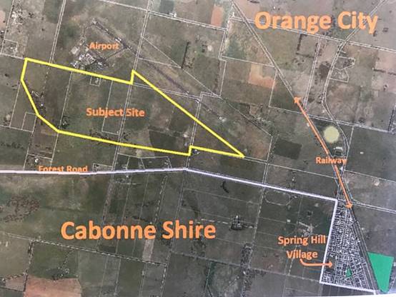
Location map
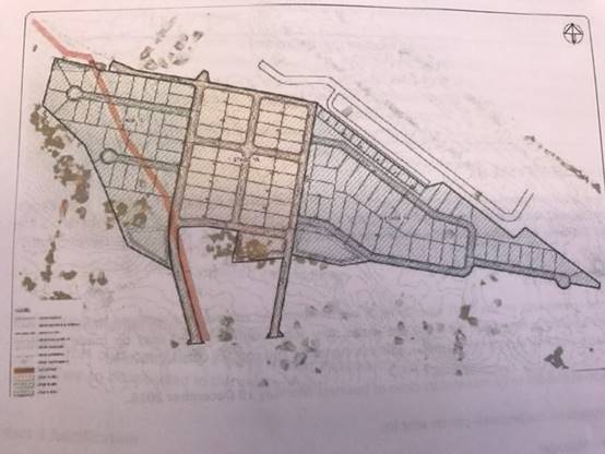
Concept plan
Cabonne Council requested an
extension of time for comments to be provided to Orange City Council so that
Cabonne could consider the matter at its December council meeting. Orange City
Council agreed to an extension, and has since announced in local media that the
community consultation phase is to be extended until the end of January 2017.
Council may recall giving
consideration to the Spring Hill Airport Planning Proposal at its meeting of 26
April 2016. Council resolved as follows:
‘THAT
Council:
(1) Advise Orange City Council and the Department
of Planning and Environment that it does not support the ‘Orange City
Council Rural and Industrial Sub-Regional Strategy Section 16 Review and
update’ document; and
(2) Would support a review
of the ‘Councils of Blayney, Cabonne and Orange City Sub-Regional Rural
and Industrial Lands Use Strategy, July 2008’ in its entirety, with such
review to be undertaken prior to the Department of Planning and
Environment’s Gateway determination of the Spring Hill Airport rezoning
Planning Proposal, or any other sub regional planning proposal that is not in
accordance with the current endorsed sub regional rural and industrial land use
strategy.’
The revised
Gateway Determination requires that the concurrence of Cabonne and Blayney
councils be obtained by Orange City Council prior to the submission of the
latter council’s section 59 report to the Department of Planning &
Environment.
Whilst the
latest amendment to the Orange City Council Planning Proposal further reduces
the initial area proposed for industrial development and business activity, it
is noted that the addendum seeking variation to the adopted Sub Regional Rural
and Industrial Strategy 2008 does not address the sub regional status of demand
and supply of rural and industrial land. The addendum represents a review of
land within the Orange City Council Local Government Area.
Section 23A of the Local Government Act “Council decision
making during merger proposal periods” requires Council to consider these
guidelines and assess any impact upon a determination. The guidelines have been
considered and the proposed development and determination for approval is not
contrary to the guidelines.
ITEM 27 - DRAFT CONTAMINATED
LAND POLICY
REPORT IN BRIEF
|
Reason For Report
|
To obtain
council's resolution to place the draft contaminated lands policy on public
exhibition.
|
|
Policy Implications
|
Drafting
of a policy to address contaminated land
|
|
Budget Implications
|
Staff
resourcing will be required to establish and maintain the register, however
provision for this task may be provided within existing staffing
resources and in association with the resources provided under the terms of
the regional grant program.
|
|
IPR Linkage
|
4.5.3.f - Participate in
relevant reference groups and meetings
|
|
Annexures
|
1. Draft
Contaminated Land Policy - Contamination Central Dec 2016⇩
|
|
File Number
|
\OFFICIAL
RECORDS LIBRARY\ENVIRONMENTAL MANAGEMENT\PLANNING\CONTAMINATED LAND
MANAGEMENT - 797130
|
|
Recommendation
THAT the draft
Contaminated Land Policy be placed on public exhibition.
|
Director of Environmental Services' REPORT
Cabonne Council is a participant
in a regional program that was successful in obtaining funding from the NSW
State Government to prepare a Contaminated Land Policy that will be generally
consistent between all of the member councils in the Central West.
The program known as
Contamination Central has delivered a suite of information including the draft
policy document to assist council meet its environmental obligations and to
enable increased delivery of services to land owners, prospective purchasers
and developers by advising of any known restrictions on the use of land as a
result of previous land uses and the potential contamination that may have
resulted. This action will ensure both current and future land owners are aware
of possible health and safety risks of particular land, such as former
industrial or mining sites.
When adopted the policy would
provide guidelines and procedures for use by council when issuing Planning
Certificates under section 149(2) and (5) of the Environmental Planning &
Assessment Act 1979.
The adoption and implementation
of the contaminated lands policy would have benefit to the environmental
management of lands within Cabonne Council, and a cumulative benefit across the
Central West region.
The draft policy has been
developed by a Steering Committee and the Regional Contamination Officer, Craig
Flemming who is based at Orange City Council. The draft Contaminated Land
policy is attached, and sets out the procedures for the management of
contaminated land within the council area. The policy reflects the requirements
of the relevant State legislation, particularly State Environmental Planning
Policy 55 – Remediation of Land.
The implementation of the policy
will have an initial impact upon council’s staff resources as it will
require the identification of current and historical uses of industrial and
commercial land. The document will enable council to develop a data base of
information that can be utilised to advise land owners and prospective
purchasers of the likelihood of contaminated sites and the measures required to
manage the site into the future.
It is understood that the
Regional Contamination Coordinator will continue to be available to work with
council to develop the data base and assist with the implementation of the
policy.
It is proposed that the draft
policy and management plan be placed upon public exhibition in order to engage
with the community and seek feedback, before council gives consideration to the
adoption of the regionally endorsed policy.
Section 23A
of the Local Government Act “Council decision making during merger
proposal periods” requires Council to consider these guidelines and
assess any impact upon a determination. The guidelines have been considered and
the proposed development and determination for approval is not contrary to the
guidelines.
ITEM 28 - QUESTIONS FOR NEXT
MEETING
REPORT IN BRIEF
|
Reason For Report
|
To provide
Councillors with an opportunity to ask questions/raise matters which can be
provided/addressed at the next Council meeting.
|
|
Policy Implications
|
Nil
|
|
Budget Implications
|
Nil
|
|
IPR Linkage
|
4.5.1.g. Code of Meeting
Practice adhered to
|
|
Annexures
|
Nil
|
|
File Number
|
\OFFICIAL
RECORDS LIBRARY\GOVERNANCE\COUNCIL MEETINGS\NOTICES - MEETINGS - 796350
|
|
Recommendation
THAT Council receive a report at the next Council meeting in
relation to questions asked/matters raised where necessary.
|
Acting General Manager's REPORT
A call for questions for which an
answer is to be provided if possible or a report submitted to the next Council
meeting.
Please note that guidelines have
been issued under Section 23A of the Local Government Act titled “Council
decision making during merger proposal periods”. Council must consider
the guidelines in relation to each decision they make during the proposal
period, this matter is of an ongoing nature and it is considered it complies
with the guidelines.
ITEM
29 - BUSINESS PAPER ITEMS FOR NOTING
REPORT IN
BRIEF
|
Reason For Report
|
Provides an opportunity for
Councillors to call items for noting for discussion and recommends remainder
to be noted.
|
|
Policy Implications
|
Nil
|
|
Budget Implications
|
Nil
|
|
IPR Linkage
|
4.5.1.g - Code of Meeting
Practice adopted and implemented.
|
|
Annexures
|
Nil
|
|
File Number
|
\OFFICIAL RECORDS
LIBRARY\GOVERNANCE\COUNCIL MEETINGS\PROCEDURES - 796351
|
|
Recommendation
THAT:
1. Councillors
call any items they wish to further consider.
2. The
balance of the items be noted.
|
Acting General Manager's REPORT
In the second part of
Council’s Business Paper are items included for Council’s
information.
In accordance with
Council’s format for its Business Paper, Councillors wishing to discuss any
item are requested to call that item.
Please note that guidelines have
been issued under Section 23A of the Local Government Act titled “Council
decision making during merger proposal periods”. Council must consider
the guidelines in relation to each decision they make during the proposal
period, as these items are for noting it is considered that they are of a
nature which complies with the guidelines, however should a called item be
proposed to have a resolution other than notation Council would need to further
consider how the guidelines apply.
ITEM 30 - MATTERS OF URGENCY
REPORT IN BRIEF
|
Reason For Report
|
Enabling
matters of urgency to be called.
|
|
Policy Implications
|
Nil
|
|
Budget Implications
|
Nil
|
|
IPR Linkage
|
4.5.1.a. Provide quality administrative
support and governance to councillors and residents
|
|
Annexures
|
Nil
|
|
File Number
|
\OFFICIAL
RECORDS LIBRARY\GOVERNANCE\COUNCIL MEETINGS\NOTICES - MEETINGS - 796352
|
|
Recommendation
THAT
Councillors call any matters of urgency.
|
Acting General Manager's REPORT
Council’s Code of Meeting
Practice allows for the Council to consider matters of urgency which are
defined as “any matter which requires a decision prior to the
next meeting or a matter which has arisen which needs to be brought to
Council’s attention without delay such as natural disasters, states of
emergency, or urgent deadlines that must be met”.
This item enables councillors to
raise any item that meets this definition.
Please note that guidelines have
been issued under Section 23A of the Local Government Act titled “Council
decision making during merger proposal periods”. Council must consider
the guidelines in relation to each decision they make during the proposal
period, Council will need to consider the guidelines in conjunction with any
matters of urgency.
ITEM 31 - COMMITTEE OF THE
WHOLE SECTION OF THE MEETING
REPORT IN BRIEF
|
Reason For Report
|
Enabling
reports to be considered in Committee of the Whole.
|
|
Policy Implications
|
Nil
|
|
Budget Implications
|
Nil
|
|
IPR Linkage
|
4.5.1.g. Code of Meeting
Practice adhered to
|
|
Annexures
|
Nil
|
|
File Number
|
\OFFICIAL
RECORDS LIBRARY\GOVERNANCE\COUNCIL MEETINGS\PROCEDURES - 796353
|
|
Recommendation
THAT Council
hereby resolve itself into Committee of the Whole to discuss matters called
earlier in the meeting.
|
Acting General Manager's REPORT
Council’s Code of Meeting
Practice allows for the Council to resolve itself into “committee of the
whole” to avoid the necessity of limiting the number and duration of
speeches as required by Clause 250 of the Local Government (General) Regulation
2005.
This item enables councillors to
go into “committee of the whole” to discuss items called earlier in
the meeting.
Please note that guidelines have
been issued under Section 23A of the Local Government Act titled “Council
decision making during merger proposal periods”. Council must consider
the guidelines in relation to each decision they make during the proposal
period, this matter is of an ongoing nature and it is considered it complies
with the guidelines.
|
Item 7 Ordinary
Meeting 20 December 2016
|
Item 7 - Annexure 1
|
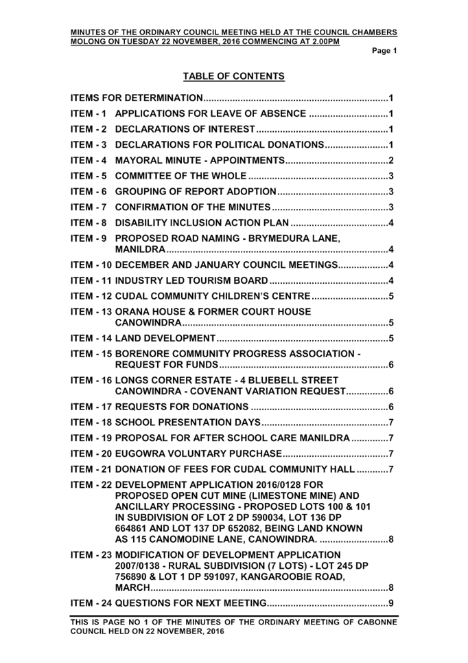
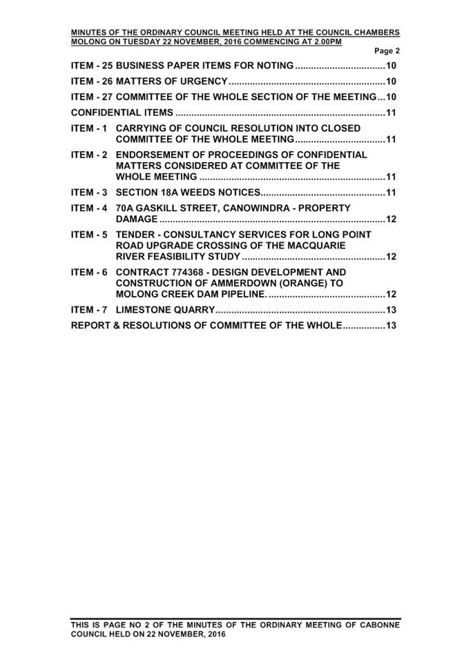
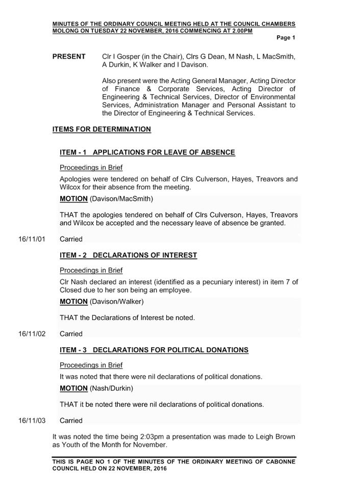
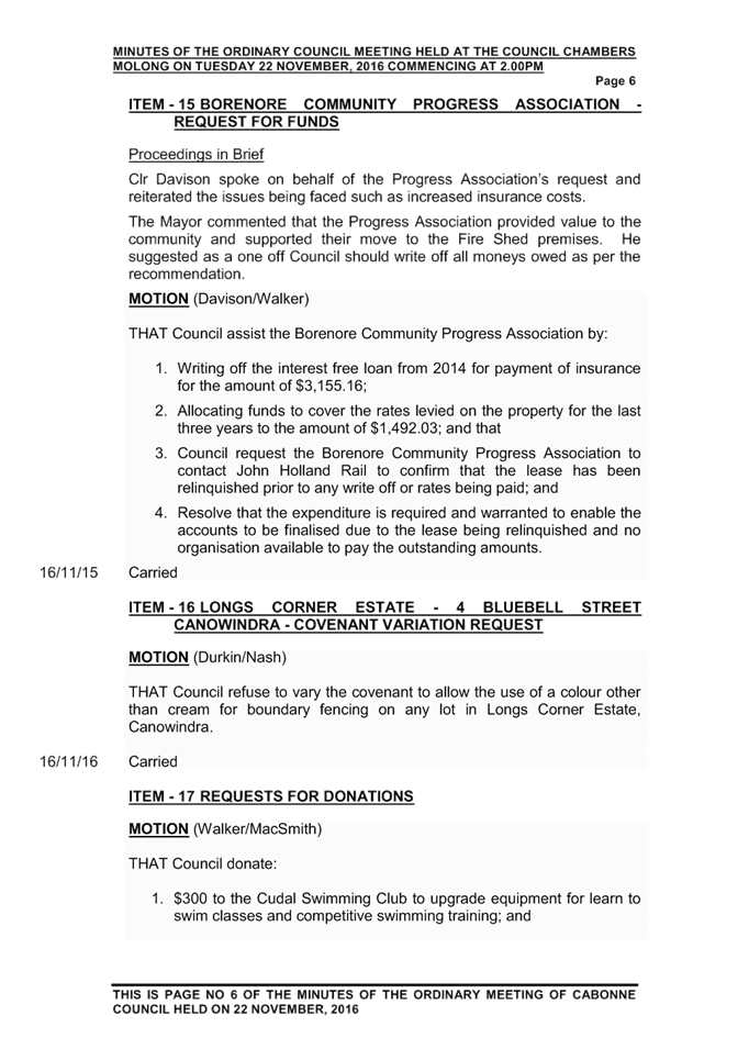
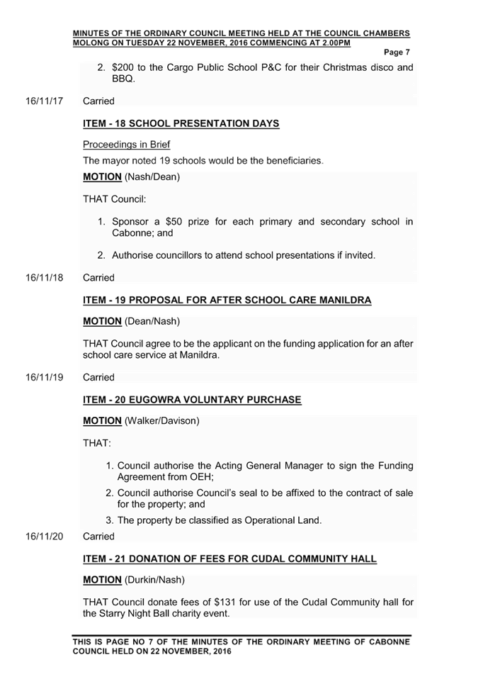
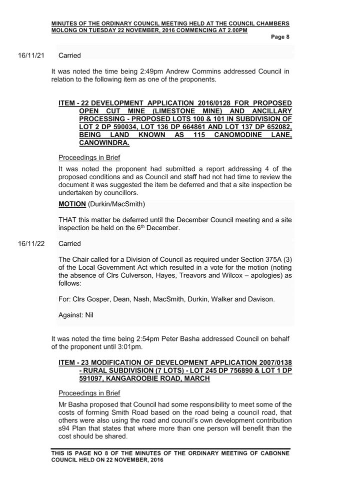
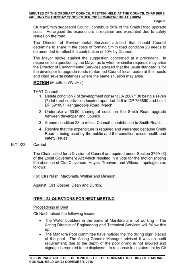
|
Item 8 Ordinary Meeting 20 December 2016
|
Item 8 - Annexure 1
|
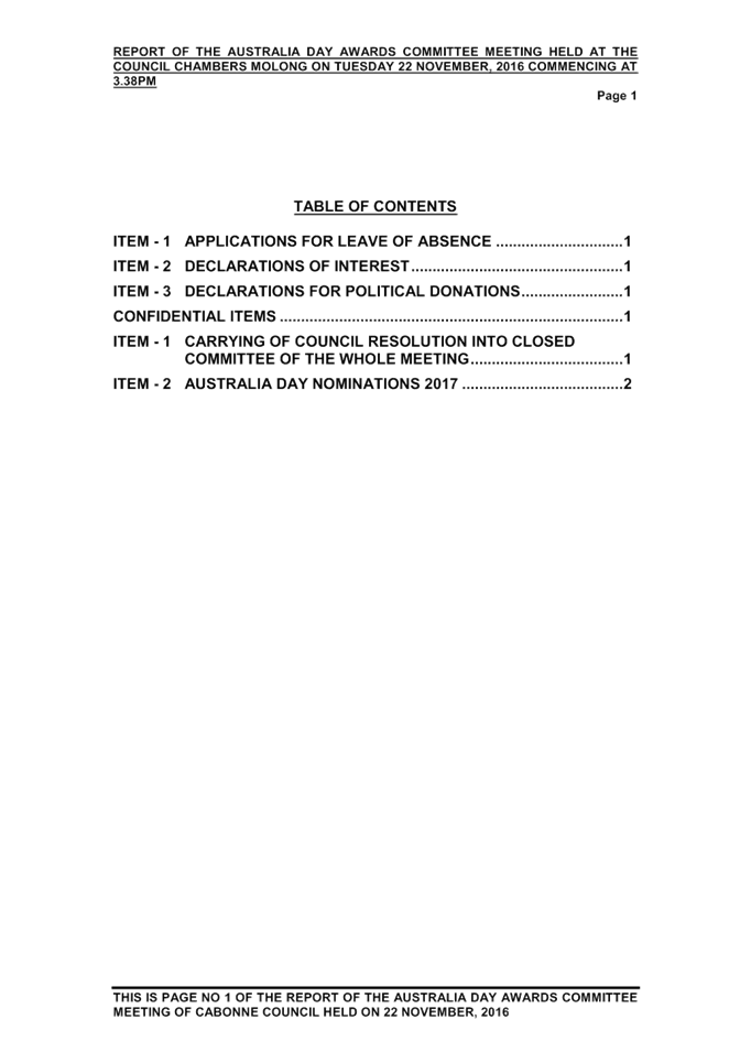
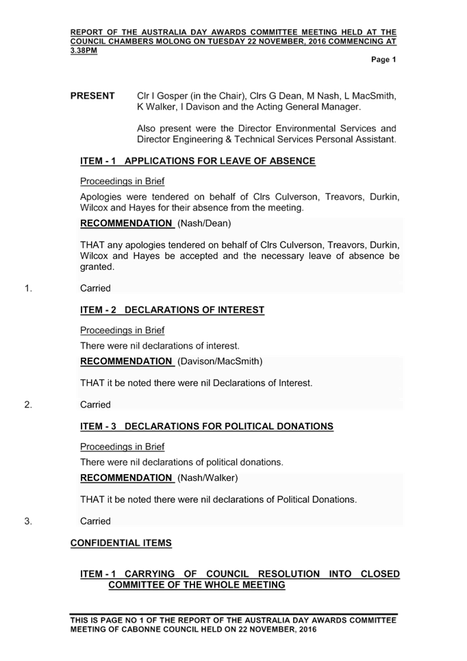
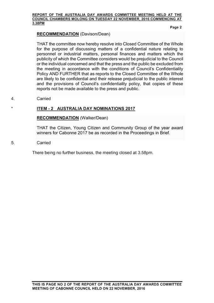
|
Item 12 Ordinary Meeting 20 December 2016
|
Item 12 - Annexure 1
|
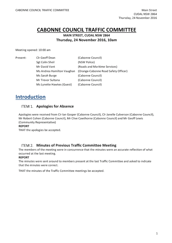
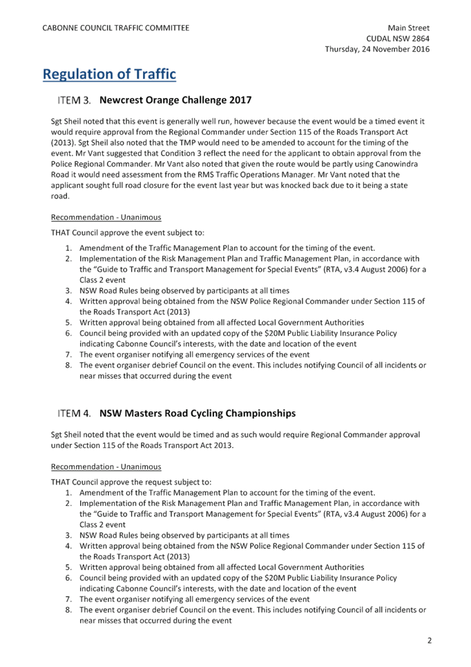
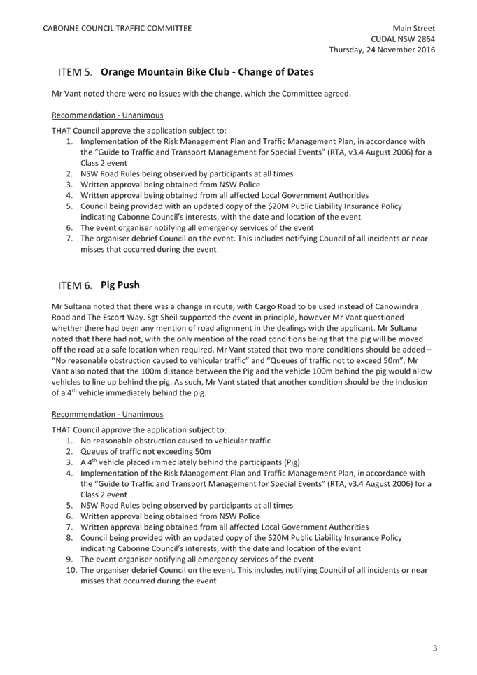
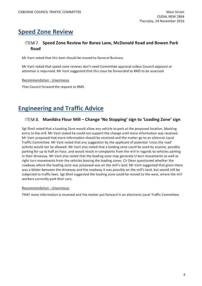
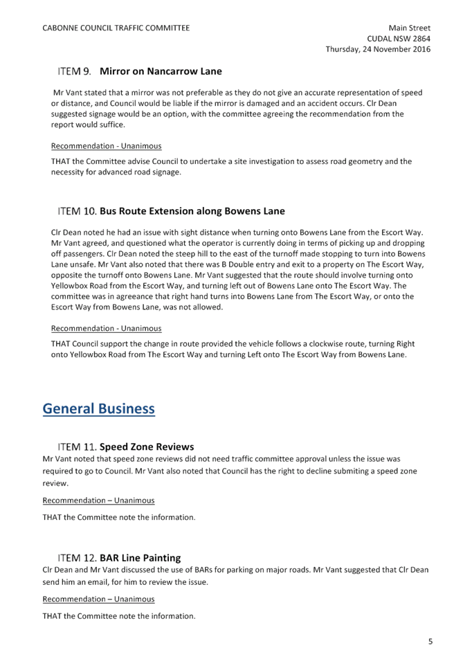
|
Item 13 Ordinary Meeting 20 December 2016
|
Item 13 - Annexure 1
|

|
Item 15 Ordinary Meeting 20 December 2016
|
Item 15 - Annexure 1
|
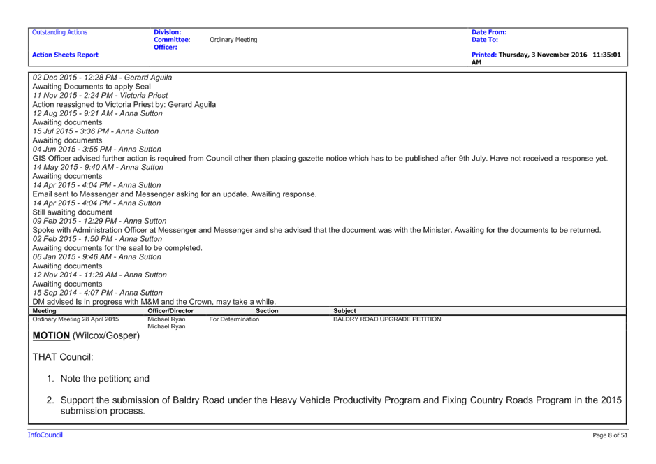
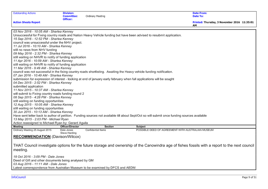
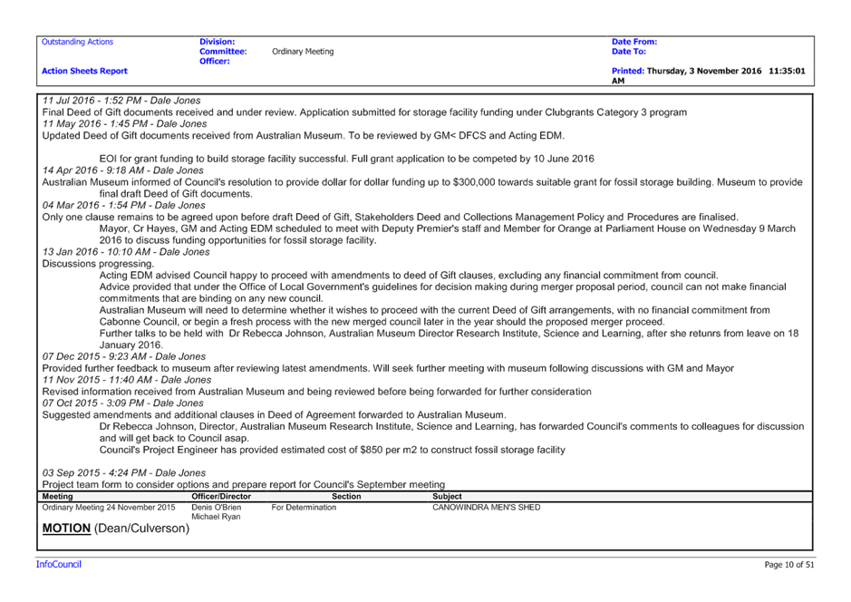
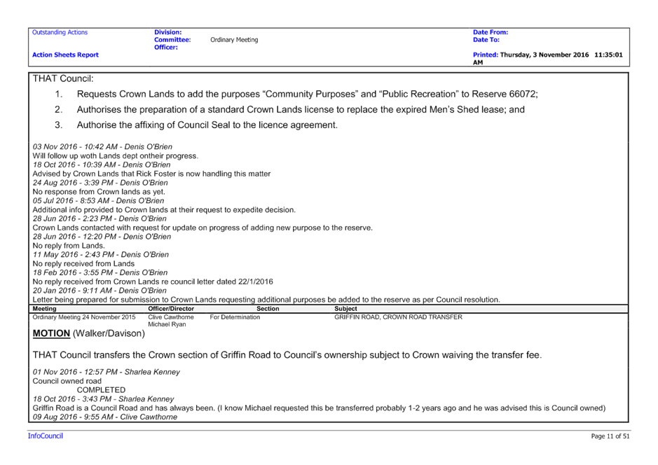
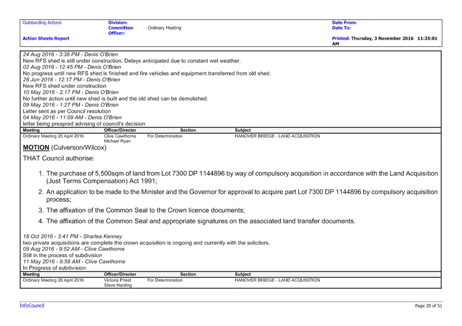
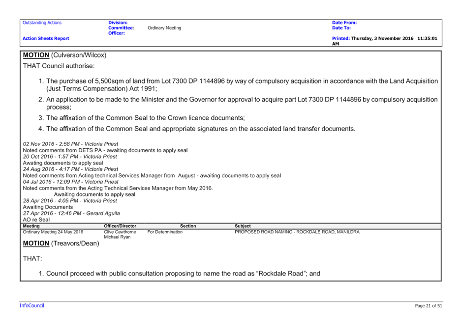
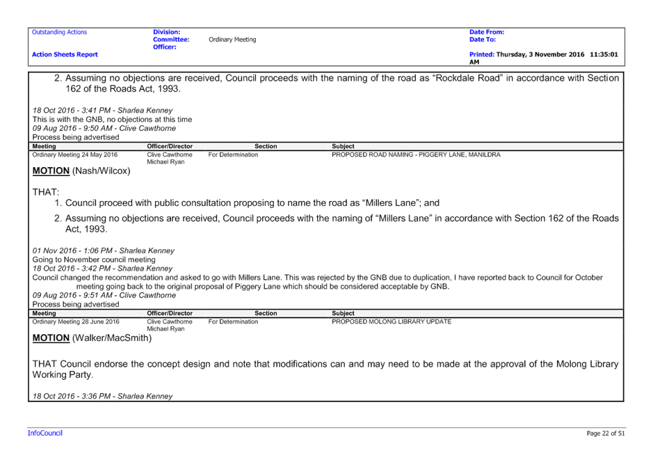
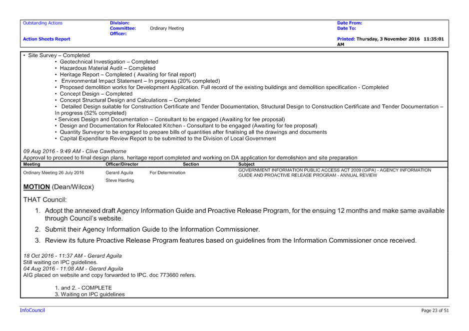
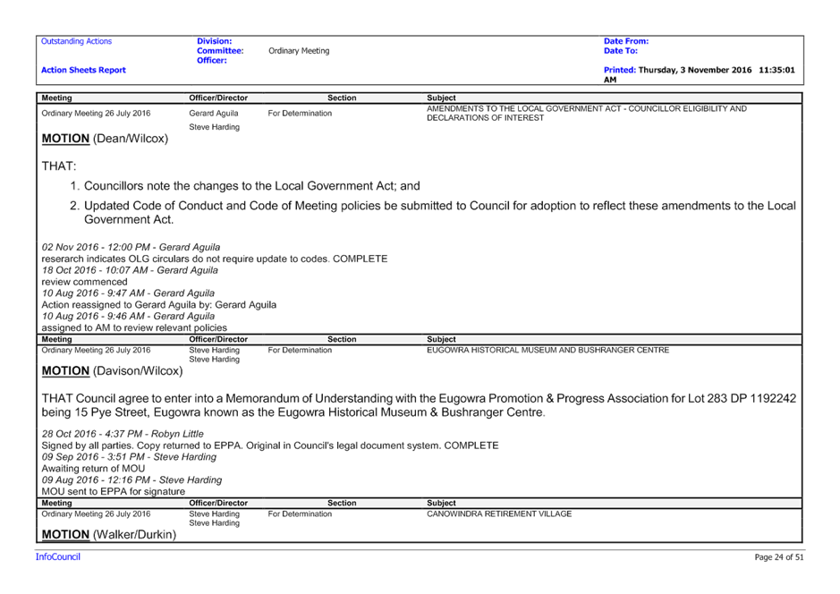
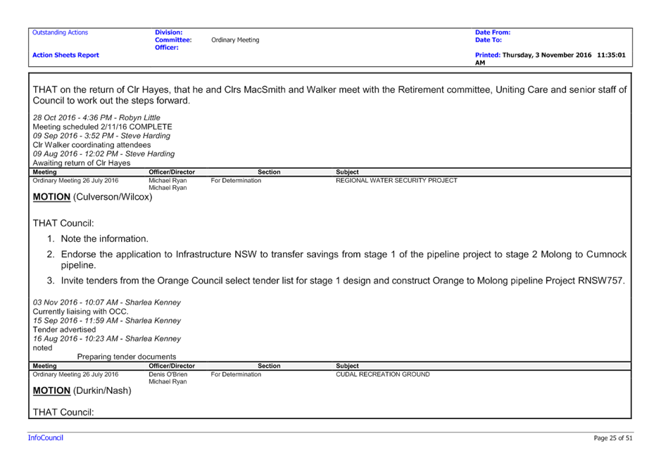
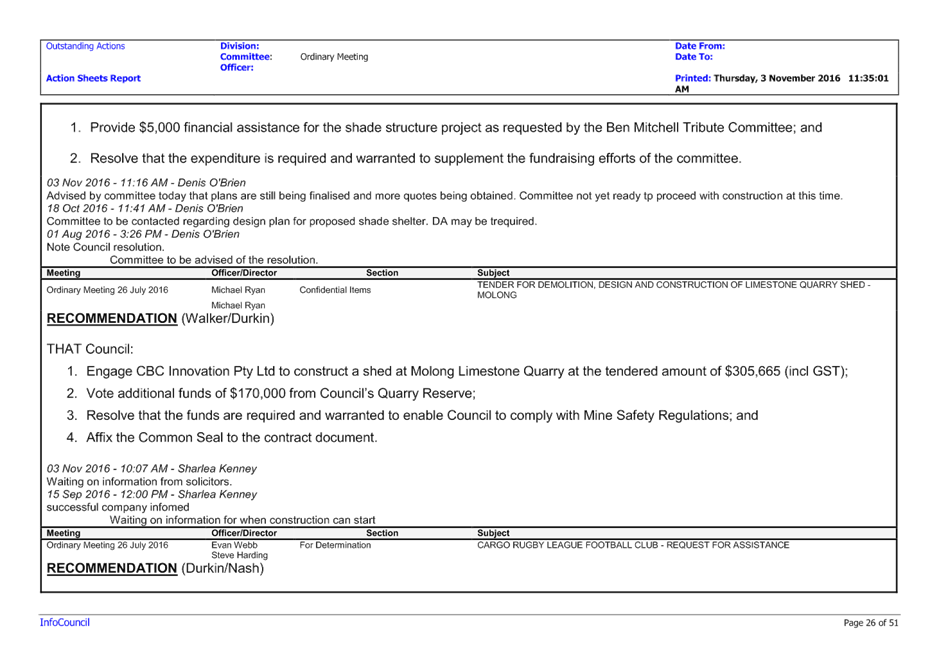
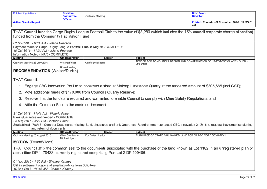
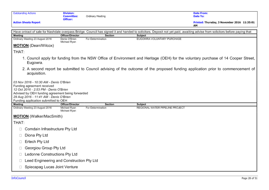
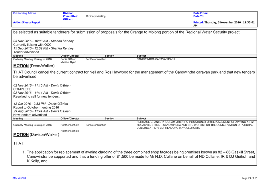
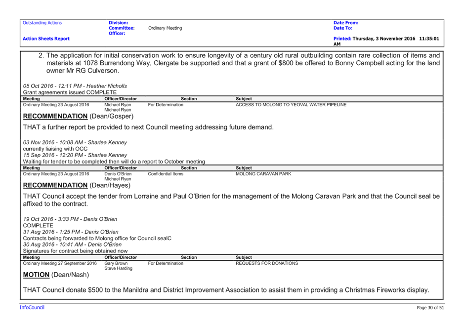
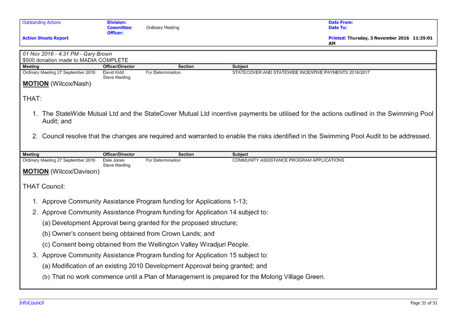
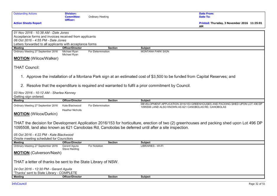
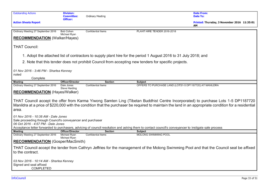
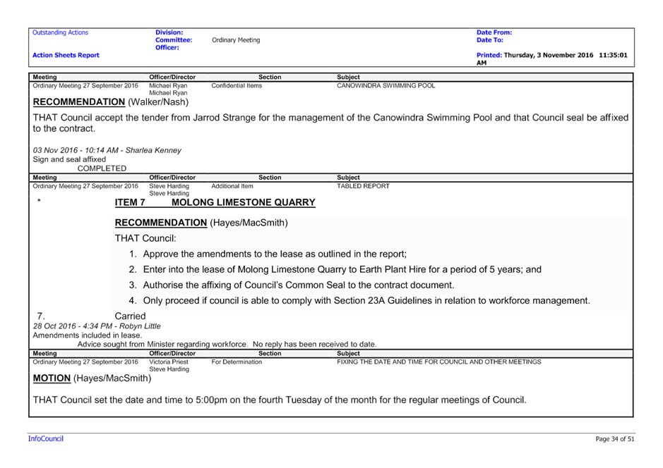
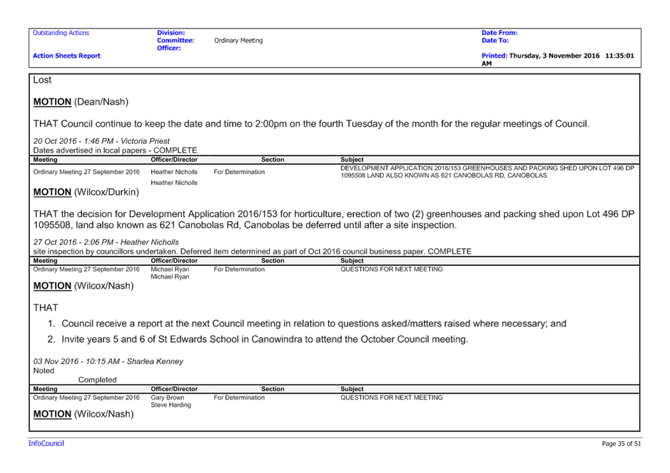
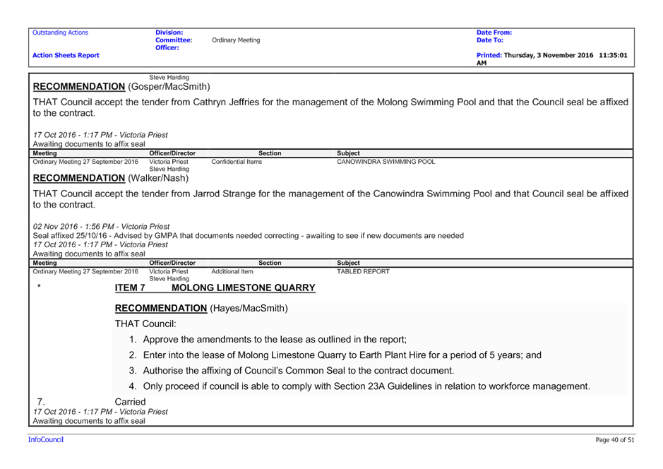
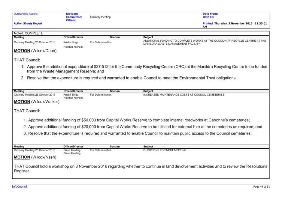
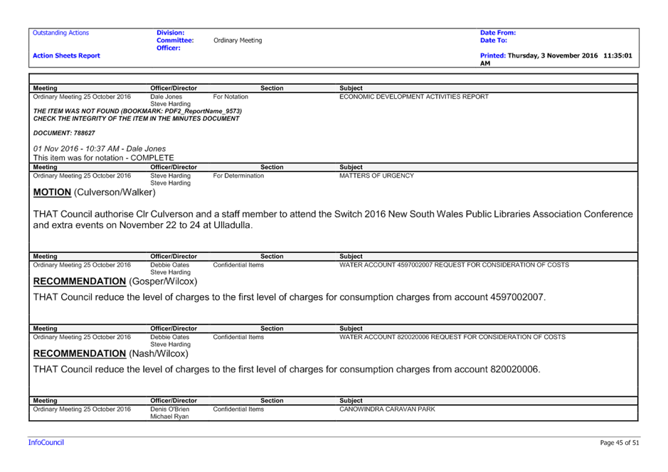
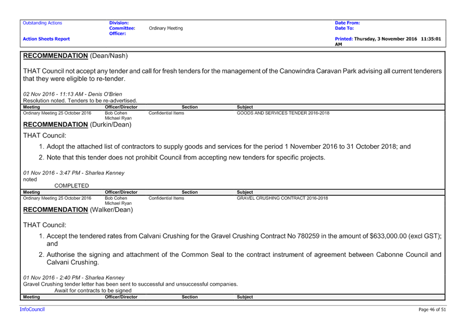
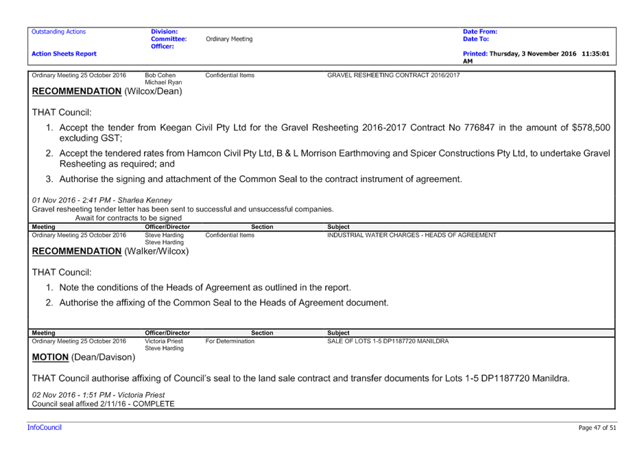
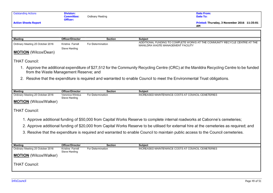
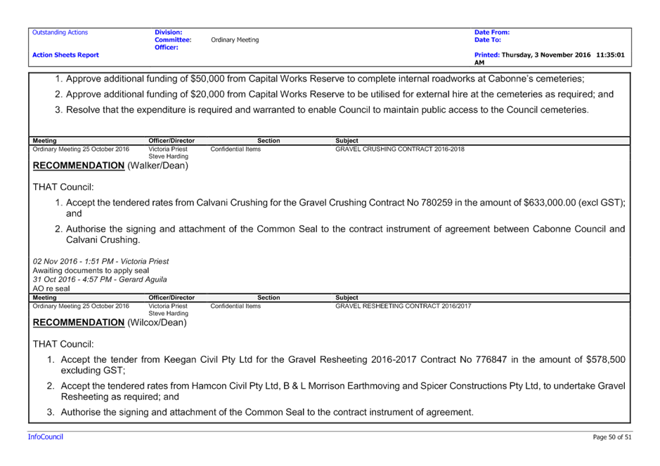
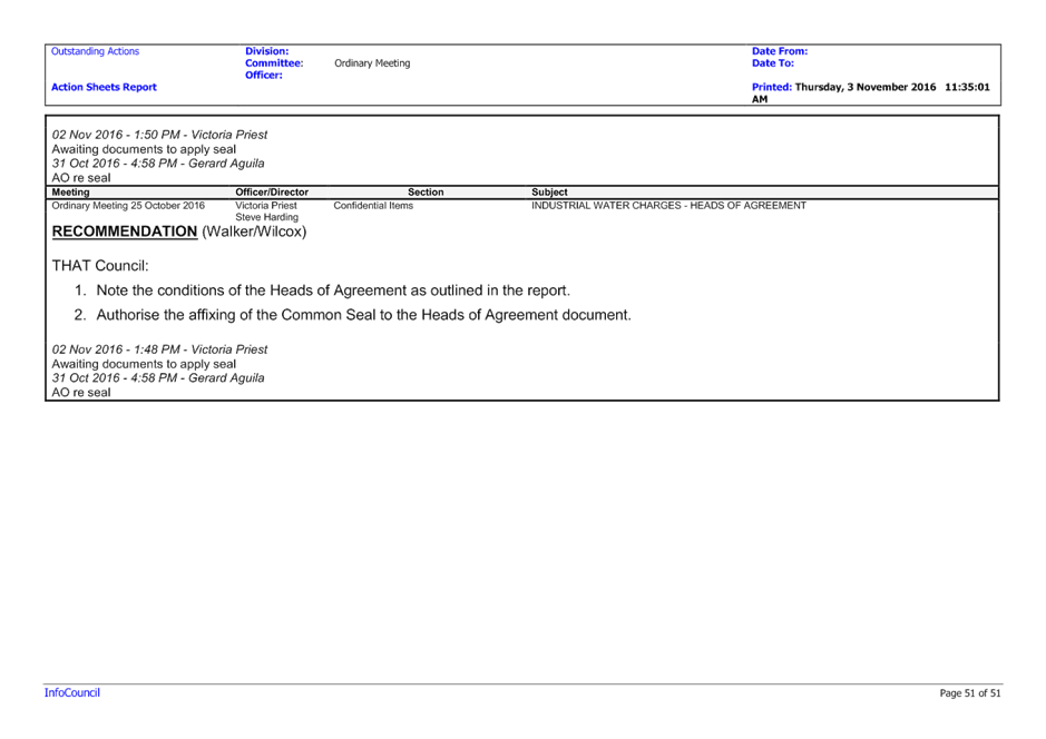
|
Item 17 Ordinary Meeting 20 December 2016
|
Item 17 - Annexure 1
|
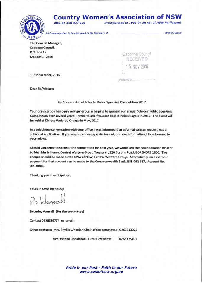
|
Item 20 Ordinary Meeting 20 December 2016
|
Item 20 - Annexure 1
|

|
Item 23 Ordinary Meeting 20 December 2016
|
Item 23 - Annexure 1
|
DRAFT CONDITION OF
CONSENT
DA 2016/0128
1. DEVELOPMENT
IN ACCORDANCE WITH PLANS
Objective
To ensure the development
proceeds in the manner assessed by council.
Performance
Development is to take place in
accordance with the attached stamped plans (Ref: DA 2016/128), the
Environmental Impact Statement prepared by RW Corkery & Co Pty Ltd dated
March 2016 and associated documentation submitted with the application and subject
to the conditions below, to ensure the development is consistent with
Council’s consent.
NOTE: Any alterations to
the approved development application plans must be clearly identified with the
application for a construction certificate.
The Principal Certifying
Authority for the project may request an application for modification of this
consent or a new application in the event that changes to the approved plans
are subsequently made. An application to modify the development consent
under s96 of the Environmental Planning and Assessment Act, 1979, as amended
and will be subject to a separate fee.
2. ANNUAL
EXTRACTION AND PRODUCTION RATE
Objective
To ensure the proposal operates
in accordance with the proposed, assessed and determined proposal.
Performance
The proposed extraction and
crushing of limestone shall be limited to 250,000 tonnes per year.
3. HOURS OF
OPERATION
Objective
To ensure the proposal hours of
operation are in accordance with the proposed, assessed and determined
proposal.
Performance
Construction and operational
activities relating to the development must only be undertaken during the
following hours:
|
Activity
|
Monday to Friday
|
Saturday
|
Sunday & Public Holidays
|
|
Site establishment
Extraction
Crushing & screening
|
6am to 6pm
|
6am to 3pm
|
Nil
|
|
Blasting
|
9am to 3pm
|
Nil
|
|
Grinding
|
24 hrs
|
24 hrs
|
|
Loading and transportation
Rehabilitation
|
6am to 6pm
|
Nil
|
The hours of operation specified
above may be varied with written consent if the EPA is satisfied that the
amenity of surrounding properties in the locality will not be adversely
affected.
4. ENVIRONMENTAL
PROTECTION AUTHORITY GENERAL TERMS OF APPROVAL
Objective
To ensure the proposal operates
in a manner not detrimental to the environment or locality.
Performance
The proposal shall comply with
the General Terms of Approval issued by NSW Environmental Protection Authority
in correspondence referenced as ‘Notice No: 1539865, Attachment A’.
(Copy attached).
5. DEPARTMENT
PRIMARY INDUSTRIES - WATER, GENERAL TERMS OF APPROVAL
Objective
To ensure the proposal operates
in a manner not detrimental to the environment or locality.
Performance
The proposal shall comply with
the General Terms of Approval issued by NSW DPI Water in correspondence dated
30 August 2016 referenced as Attachment 1. (Copy attached).
6. PROTECTION
OF ABORIGINAL SITE
Objective
To protect cultural heritage.
Performance
A high visibility fence must be
constructed with a buffer of five (5) metres surrounding the known Aboriginal
site Cargo-IF1 prior to commencement of ground works and be maintained for the
life of the project.
7. PROTECTION
OF ABORIGINAL HERITAGE
Objective
To protect Aboriginal sites and
relics.
Performance
If any previously undetected
Aboriginal sites or relics are uncovered or unearthed during any activity, work
at that location must cease immediately and an appropriate actin obtained from
the relevant Local Area Land Council in conjunction with the NSW Department of
Environment and Heritage.
8. BIODIVERSITY
PLAN OF MANAGEMENT
Objective
To ensure that the environmental
impact is adequately managed.
Performance
A detailed Plan of Management
must be prepared for the proposed Biodiversity Offset Area to ensure that the
offsets are appropriately managed and funded. The Plan of Management must
include;
(a) Measurable performance indicators and targets. The performance
targets should reflect the different stages of succession of biodiversity
management. Additionally, targets should relate to actual biodiversity outputs,
including species requirements throughout different stages of succession,
rather than simply inputs and outputs.
(b) Trigger points and subsequent corrective actions to be implemented
id the monitoring program identifies that the performance targets (and
therefore biodiversity management objectives) are not being met, and
(c) A monitoring program that will assess the effectiveness of
the management activities against the management objectives and performance
indicators and targets
The Plan of Management must be
submitted to the Office of Heritage and Environment for review.
9. SUPPLEMENTARY
PLANTING WITHIN BIODIVERSITY OFFSET AREA
Objective
To enhance the ecological
management of the area.
Performance
Supplementary planting be
conducted in the proposed Biodiversity Offset Area west of the project site
boundary. Bird nesting boxes are to be constructed within the area, and timber
containing hollows that is cleared from the mine site is to be relocated to the
Offset Area as habitat.
10. EXPANSION OF
BIODIVERSITY OFFSET AREA
Objective
To enhance the integrity of the
ecological management of the area.
Performance
Additional areas of Box Gum
Woodland EEC in woodland or derived native grassland form be sourced to provide
a minimum offset area of 55 hectares.
11. BIODIVERSITY OFFSET
AREA PERPETUITY
Objective
To ensure the perpetuity of the
ecological management of the area.
Performance
The Biodiversity Offset Area must
be secured in perpetuity using an appropriate legal mechanism. The Office of
Environment and Heritage’s preferred mechanism is a BioBanking agreement.
Should the proponent intent to
pursue a Property Vegetation Plan, both Cabonne Council and the proponent must
liaise with the Central Tablelands Local Lands Service to determine whether
this is a viable option for this project. Contact officer Tiffany Bracey,
contact on 02 6391 3911 or email tiffany.bracey@lls.nsw.gov.au
12. EVIDENCE OF
FORMALISED BIODIVERSITY OFFSET AREA AGREEMENT
Objective
To ensure perpetuity of the
Biodiversity Offset Area is recorded on the land title deed(s).
Performance
Documentary evidence of lodgement
with Lands and Property Information authority of a section 88B instrument is to
be submitted to Cabonne Council within 12 months of the date of this consent.
The terms of the instrument are to reflect the EIS and additional requirements
of Office of Environment and Heritage.
13. CLEARING OF NATIVE
VEGETATION
Objective
To ensure the impact of the
development on identified and potential threatened species is minimal or
negligible.
Performance
The clearing of native vegetation
is prohibited unless it is in accordance with the provisions of the Native
Vegetation Act 1993 as amended.
14. REHABILITATION
OBJECTIVES AND COMMITMENTS
Objective
To ensure the proposal operates
in a manner that is not detrimental to the environment or locality.
Performance
The proponent must rehabilitate
the site to the satisfaction of the Director, Environmental Sustainability Unit
of the Division of Resources and Energy, NSW Department of Industry.
Rehabilitation must be
substantially consistent with the rehabilitation objectives described in the
EIS and the following objectives in the table below:
|
Rehabilitation Feature
|
Objective
|
|
Mine site (as a whole of the
disturbed land and water)
|
Safe, stable and non-polluting,
fit for the purpose of the intended post mining land use(s).
|
|
Rehabilitation materials
|
Materials(including topsoils,
substrates and seeds of the disturbed areas) are covered, appropriately
managed and used effectively as resources in the rehabilitation.
|
|
Landforms
|
Final landforms sustain the
intended land use for the post-mining domain(s).
Final landforms are consistent
with and complement the topography of the surrounding region to minimise the
visual prominence of the final landforms in the post mining landscape.
Final landforms incorporate
design relief patterns and principles consistent with natural drainage.
|
|
Water quality
|
Water retained on site is fit
for the intended land use(s) for the post mining domain(s).
Water discharged from the site
is consistent with the baseline ecological, hydrological and geomorphic
conditions of the creeks prior to the mining disturbance.
Water management is consistent
with the regional catchment strategy.
|
|
Native flora and fauna habitat
and corridors
|
Size, locations and species of
native tree lots and corridors are established to sustain biodiversity
habitats.
Species are selected that
re-establishes and complements regional and local biodiversity
|
|
Post-mining agricultural
pursuits
|
The land capability
classification for the relevant nominated agricultural pursuit for each
domain is established and self-sustaining within 5 years of land use
establishment (first planting of vegetation).
|
15. PROGRESSIVE
REHABILITATION
Objective
To ensure environmental
management of the site.
Performance
The proponent shall carry out all
surface disturbing activities (eg Pre-stripping in advance of mining
operations) in a manner that, as far is reasonably practicable, minimises
potential for dust emissions and shall carry out rehabilitation of disturbed
areas progressively, as soon as reasonably practicable, to the satisfaction of
the Director Environmental Sustainability, of the Division of Resources and
Energy, Department of Industry, Skills and Regional Development.
16. REHABILITATION PLAN
Objective
To ensure environmental
management of the site.
Performance
The proponent must prepare and
implement a Rehabilitation Plan to the satisfaction of the Director
Environmental Sustainability of the Division of Resources and Energy,
Department of Industry, Skills and Regional Development, Department of
Industries.
The Rehabilitation Plan must:
(a) Be submitted and approved by the Director Environmental
Sustainability prior to carrying out any surface disturbing activities of the
development, unless otherwise agreed by the Secretary, Department of Industry,
(b) Be prepared in accordance with Division of Resource and Energy
guidelines and in consultation with Department of Industry, Office of
Environment and Heritage, Environmental Protection Authority, Department
Primary Industry – Water and Cabonne Council,
(c) Incorporate and be consistent with the rehabilitation
objectives of the Environmental Impact Study,
(d) Integrate and build on, to the maximum extent practicable, the
other management plans required under this approval, and
(e) Address all aspects of mine closure and rehabilitation, including
post mining land use domains, rehabilitation objectives, completion criteria
and rehabilitation monitoring and management.
Note: The
approved Mining Operation Plan is required as a condition of the Mining
Lease(s) issued in relation to this project and will satisfy the requirements
of this condition foe a Rehabilitation Plan.
17. APPLICATION OF
BITUMEN SEAL TO THE INTERNAL SITE ACCESS ROAD
Objective
To ensure a suitable all weather,
non-dust generating internal access road is provided.
Performance
The applicant is required to
provide a bitumen sealed surface to the internal access road between Canomodine
Lane and the infrastructure area which shall be maintained at all times.
18. ADEQUATE ONSITE
TRUCK PARKING
Objective
To provide an adequate onsite
truck parking area.
Performance
The proponent shall ensure that:
(a) All vehicle parking is contained within the site
(b) No vehicles associated with the development shall be parked in the
public road system, and
(c) Vehicles do not queue on public roads at any time.
19. PROVISION OF PRIVATE
ACCESS
Objective
To ensure that safe and practical
access is provided to the subject land.
Performance
The applicant must provide a
formal and practical access to Lot 2 DP 590034, Lot 136 DP 664861 and Lot 137
DP 652082 in the form of a basic right (BAR) and a
basic left (BAL) turn treatment as shown in Figure 7.5 and Figure 8.2 Part 4A Austroads
Guide to Road Design at the intersection of the internal access road and
Canomodine Lane. The full width of the access point including the widened
shoulders are to be bitumen sealed.
Prior to any Access Construction
Certificate being issued, the applicant will be required to submit to Council
for approval a detailed design of the proposed access.
An Access Construction
Certificate must be obtained prior to commencement of construction of
any access to the property from Canomodine Lane.
A joint inspection with the
Principal Certifying Authority is to be held prior to commencing construction
of the access. Please telephone Council’s Development Engineer on
6392 3247 to arrange a suitable date and time for the inspection.
An Access Compliance Certificate
for the access/ intersection must be issued by Council prior to
the transporting of any extractive material from the site.
20. ROAD DESIGN AND
CONSTRUCTION (CANOMODINE LANE)
Objective
To ensure that the road upgrade
is constructed in accordance with council’s requirements.
Performance
The applicant is
required to bear the full cost of survey, design and construction of the
proposed upgrade of Canomodine Lane which is to be built to a minimum design
requirement for a “Rural Collector” road (10.0m seal width on a
10.0m formation).
A complete set
of drawings is to be provided to council for approval before any ROADWORKS CONSTRUCTION CERTIFICATE is issued for the works.
A ROADWORKS
COMPLIANCE CERTIFICATE FOR ALL ROAD WORKS IS TO BE ISSUED.
One set of printed copies plus an
electronic copy (AutoCAD2000.dwg file format) of “Works as
Executed” plans are to be submitted to Council for works carried out on
Council’s Road in CONNECTION WITH THE APPLICATION FOR A ROADWORKS
COMPLIANCE CERTIFICATE.
All relevant
work to be completed PRIOR to the transporting of any extractive
material from the site.
21. EROSION AND
SEDIMENTATION CONTROL PLANS
Objective
To prevent sediment and erosion from
leaving the site and any watercourse contamination during construction of the
Internal Access Road, Access Point, Upgrade to Canomodine Lane and Upgrade to
the intersection of Canomodine Lane and Cargo Road.
Performance
An overall erosion and sedimentation
control plan is to be prepared for the site to a standard acceptable to the
Principal Certifying.
The plan is to note any proposed
vegetation retention and planting and is to be submitted to and approved by
Council prior to any construction works commencing.
Specific construction zone
erosion and sedimentation control plans are to be prepared to a standard
acceptable to the Principal Certifying Authority and are required to be
approved prior to the issue of Construction Certificates for each and any stage
of the development.
22. PUBLIC LIABILITY
INSURANCE
Objective
To ensure that council, Roads and
Maritime Services and the applicant are all protected against any liability
claim.
Performance
Prior to the commencement of any
roadworks on council or Roads and Maritime Services controlled land including a
public road, the applicant is to affect Public Liability Insurance in the
minimum amount of $20 million. This insurance is to note both council and Roads
and Maritime Services as interested parties and is to remain current for at
least the period from the issue of the Construction Certificate until the issue
of a Compliance Certificate for the roadworks. Documentary evidence of
the currency of this cover is to be provided to Council at the time when
applying for a Roadworks Construction Certificate.
23. ENTRANCE / EXIT
POINTS
Objective
To ensure on-site traffic flows
in the manner assessed by council.
Performance
Entrance / exit points are to be
clearly signposted and visible from both the street and the site at all times.
24. LOADING / UNLOADING
Objective
To ensure loading / unloading
does not interfere with the amenity of the roadway.
Performance
All loading and unloading
operations are to take place at all times wholly within the confines of the
site.
25. DUST SUPPRESSION
Objective
To ensure that dust does not
become a nuisance to neighbouring properties or passing motorists.
Performance
The applicant will ensure to
water down any nuisance dust that may arise from Canomodine Lane and its
intersection with Cargo Road during the construction of the road and
intersection upgrade.
26. VEHICLE MANAGEMENT
PLAN
Objective
To ensure that arrangements are
made for all vehicles movements associated with the development.
Performance
The vehicle management plan is to
detail all vehicle movements within the site including loading areas, truck
parking/waiting areas, re-fueling zones and travel routes that are used during
operation of the limestone quarry.
All persons involved in the
quarry operations shall be issued with a copy of the Vehicle Management Plan. The
Vehicle Management Plan shall be prepared by the applicant and then submitted
for approval by Council prior to the transporting of any extractive
material from the site.
27. COMPLIANCE WITH RMS
CONDITIONS
Objective
To ensure that all Roads and
Maritime Services conditions are complied with.
Performance
• A
basic right (BAR) turn treatment as shown in Figure 7.5 Part 4A Austroads
Guide to Road Design is to be provided in Cargo Road at its intersection
with Canomodine Lane. The widened shoulder is to be sealed and built for
a 100km/h speed environment to provide a reasonable level of safety for traffic
turning right into Canomodine Lane and to allow following traffic an area to
pass the right turning vehicle on the left hand side.
Note: The proposed rural school bus bay adjoining
the Cargo Road northbound travel lane is to be located on the departure side of
the intersection, not the approach side as shown in the submitted plans.
• A
basic left (BAL) turn treatment as shown in Figure 8.2 Part 4A Austroads
Guide to Road Design (copy enclosed) and the submitted plans is to be
provided in Cargo Road at its intersection with Canomodine Lane. The BAL
facility will also need to be sealed and built for a 100km/h speed environment.
The intersection is to be designed to accommodate the turning paths of the
largest vehicle required to access the mine.
• Safe
Intersection Sight Distance (SISD) requirements outlined in Part 4A Austroads
Guide to Road Design and relevant Roads and Maritime supplements are to be
provided and maintained in both directions at the intersection of Cargo Road
and Canomodine Lane.
In accordance with section 16 of State Environmental Planning Policy
(Mining, Petroleum, Production and Extractive Industries) 2007, Roads and
Maritime provides the following recommended conditions for Council’s
consideration in the determination of DA2016/128:
• All
activities including loading and unloading of goods associated with the
development are to be carried out onsite and all loads are to be adequately
covered before vehicles exit the mine.
• Haulage
operations on Cargo Road and Canomodine Lane coinciding with local student
school bus pick up/drop off times are to be avoided.
• In
accordance with clause 16(1) of State Environmental Planning Policy (Mining,
Petroleum Production and Extractive Industries) 2007, the applicant is to
prepare and implement a driver code of conduct for the task of transporting
materials on public roads.
28. ROAD UPGRADES
Objective
It is in the public interest that
environmental impacts be identified and effects mitigated.
Performance
The proponent is to deliver all
road upgrades as deemed necessary by RMS and Cabonne Council, and to the
satisfaction of those authorities, prior to any on-site mine construction works
commencing.
29. ROAD REPAIR AND
MAINTENANCE CONTRIBUTION
Objective
To ensure that the impact of the
development on infrastructure is considered and appropriately mitigated.
Performance
Within six (6) months of the
issue of this consent the proponent is required to enter into an agreement with
Cabonne Council for payment of an annual road repair and maintenance based upon
the heavy vehicle traffic generation for the development.
The contribution to council will
apply to the repair and maintenance of Cargo Road (MR 237) from its
intersection with Canomodine Lane and the intersection with the Canowindra
– Cudal Road (MR 310). The contribution calculation is to be established
by Cabonne Council. The proponent’s contribution will also include the
costs to council of engaging environmental management expertise.
30. DRIVER CODE OF
CONDUCT
Objective
In the interest of public safety.
Performance
The Driver’s Code of
Conduct outlined in the EIS must be implemented and abided to by all employees
and contractors from the time the development commences.
31. COMPLAINTS LINE -
TELEPHONE HOT LINE
Objective
To ensure the impact of the
development on the environment and surrounding properties is considered.
Performance
The proponent is required to
establish a telephone complaints hot line, for the purpose of receiving any
complaints from members of the public in relation to activities conducted at
the site, or by vehicles and plant associated with the site activity. The
proponent must notify the public of the complaints telephone line so that the
impacted community is aware of the service. This condition does not apply until
the mine site construction commences.
32. COMMUNITY
CONSULTATIVE COMMITTEE
Objective
To ensure ongoing community
engagement between the proponent, surrounding land owners and council, during
the life of the project
Performance
The proponent shall establish and
maintain a Community Consultative Committee for the life of the mine. The
Community Consultative Committee is to be established in accordance with the
Department of Planning’s guidelines.
33. ANNUAL REPORT
Objective
To respond to the public interest
in identifying and mitigating environmental impacts associated with the
development proceeding.
Performance
The proponent is required to
submit to Cabonne Council on or before the 31 December yearly an Annual Report
that includes (but is not limited to) the following:
(a) Total extraction volume for the year
(b) Total volume of material transported from the site for the year
(c) A record of any complaints received, including time / date
of complaint, details of the complaint, and any action to rectify the
complaint.
34. BUILDING CONTROL
Objective
To ensure compliance with
statutory provisions.
Performance
No building or structure may be erected
without prior gaining the appropriate approvals or permits, unless the
development is considered exempt development under SEPP (Exempt and Complying
Development Codes) 1008 or SEPP (Infrastructure) 2007.
35. ON-SITE WASTE
MANAGEMENT SYSTEM
Objective
To ensure compliance with
statutory provisions
Performance
The proponent must obtain
approval from Cabonne Council to install and operate a system of sewage
management on the site under section 68 of the Local Government Act 1993. The
installation and operation of the system must be carried out in accordance with
the conditions of approval.
Note: All plumbing and drainage
works which may be required to be carried out to comply with the approval must
be completed by a licenced plumber and to the requirements of the NSW
Environment and Health Protection Guidelines and AS/NZ Standard 1547:2000
On-site Domestic Wastewater Management, AS 3500, National Plumbing and Drainage
and the NSW Code of Practise: Plumbing and Drainage.
36. LIGHTING
Objective
To identify and manage
environmental impacts
Performance
The proponent shall ensure that
any lighting associated with the development complies with AS 4282 (INT)
Control of Obtrusive Effects of Outdoor Lighting (as amended) and is mounted,
screened and directed in such a manner that it does not create a nuisance for
surrounding properties.
37. STORAGE OF
CHEMICALS, FUELS AND OILS
Objective
To identify and manage adverse
environmental and water quality impacts
Performance
All chemicals, fuels and oils
shall be stored in appropriate bounded areas with impervious flooring and have
sufficient capacity to hold 110% of the largest container stored within the
bund area. The bund shall be designed and installed in accordance with the
requirements of all relevant Australian Standards.
ADVISORY NOTES
No advertising signage has been
approved as part of this development consent. Any signage not complying with
the exempt development provisions will require separate development consent.
 Protection of the Environment
Operations Act 1997
Protection of the Environment
Operations Act 1997
General Terms of Approval –
 Issued
Notice No: 1539865
South - Bathurst
(by Delegation)
ATTACHMENT
A
EPA's
GENERAL TERMS OF APPROVAL
Except as expressly
provided by these General Terms of Approval or by any conditions of approval
issued by Cabonne Shire Council or the conditions of an in-force environment
protection licence issued by the Environment Protection Authority, works and
activities must be carried out in accordance with the proposal contained in:
• the Development Application 2016/128
submitted to Cabonne Shire Council on 12 April 2016;
and
• the Supporting Documentation (EIS) dated March 2016;
Should any conflict
exist between the abovementioned documents, the most recent document or
revision supersedes the conflict, except where superseded by any conditions of
approval issued by Cabonne Shire Council or the conditions of an in-force
environment protection licence issued by the Environment Protection Authority.
The Proponent must
apply for and hold an in-force (i.e. issued) environment protection licence
issued by the Environment Protection Authority prior to the Proponent carrying
out any scheduled activities under the Protection of the Environment
Operations Act 1997 as proposed.
The Proponent must comply
with any additional requirements imposed by an in-force environment protection
licence issued by the Environment Protection Authority.
Attachment 1
General
Terms of Approval — for works requiring a Licence under Part 5 of the
Water Act 1912 (Monitoring Bores)

|
Our
Reference
|
Canowindra Limestone Project
|
File
No:
|
|
|
Site
Address
|
Canomodine
Lane, Canowindra
|
|
DA
Number
|
DA2016/128
|
|
I-GA
|
Cabonne
Shire Council
|
|
Number
|
Condition
|
|
Plans,
standards and guidelines
|
|
1
|
These General Terms of
Approval (GTA) only apply to activities constituting a Licence associated
with the proposed Groundwater Monitoring as conceptually defined in the
documentation relating to the Canowindra Limestone project.
Any
amendments or modifications to the proposed works may render these GTAs
invalid. If the proposed activities are amended or modified the DPI Water
must be notified to determine if any variations to these GTA will be
required.
|
|
2
|
Prior to the commencement of any works
associated with Groundwater Monitoring for the Canowindra Limestone Project,
the consent holder must obtain the necessary Licence under Part 5 of the
Water Act 1912, from DPI Water.
|
|
3
|
The licence shall lapse if the works is
not commenced and completed within three years of the date of the issue of
the licence.
|
|
4
|
The licence holder must, within (2) months of
completion or after the issue of the licence if the work is existing, furnish
to DPI WATER:
(a) Details
of the work as set out on Form "A" attached to the licence.
(b) A
plan showing accurately the location of the work in relation to the property
boundaries.
(c) Details
of any water analysis and/or pumping test.
|
|
5
|
The licensee shall allow DPI Water or any person
authorised by it, full and free access to the works, either during or after construction,
for the purpose of carrying out inspection or test of the works and its
fittings and shall carry out any work or alterations deemed necessary by the
department for the protection and proper maintenance of the works, or the
control of the water extracted and for the protection of the quality and the
prevention from pollution or contamination of sub-surface water.
|
|
6
|
If during the construction of the work, saline or
polluted water is encountered above the producing aquifer, such water shall
be sealed off by:-
(a) inserting the appropriate length(s)
of casing to a depth sufficient to exclude the saline or polluted water from
the work.
(b) cementing between the casing(s) and
the walls of the bore hole from the bottom of the casing to ground level.
Any
departure from these procedures must be approved by the department before
undertaking the work.
|
|
7
|
(a) the licensee shall notify DPI Water
if a flowing supply of water is obtained. The bore shall then be lined with
casing and cemented and a suitable closing gear shall be attached to the
borehead as specified by DPI Water.
(b) if a flowing supply of water is
obtained from the work, the licensee shall only distribute water from the
bore head by a system of pipe lines and shall not distribute it in drains,
natural or artificial channels or depressions.
|
|
|
|
|
|

www.water.nsw.qov.au
209 Cobra
Street, Dubbo, NSW 2830 | PO Box 717 Dubbo, NSW 2830, Australia I e
water.enquiries@dpi.nsw.gov.au
 Attachment 1
|
Our
Reference
|
Canowindra
Limestone Project
|
File
No:
|
|
|
Site
Address
|
Canomodine
Lane, Canowindra
|
|
DA
Number
|
DA2016/128
|
|
I-GA
|
Cabonne
Shire Council
|
|
Number
|
Condition
|
|
8
|
If a work is abandoned at any time
the licensee shall notify DPI Water that the work has been abandoned and seal
off the aquifer by:-
(a) backfilling
the work to ground level with clay or cement after withdrawing the casing
(lining); or
(b) such
methods as agreed to or directed by DPI Water.
|
|
9
|
The
licensee shall not allow any tailwater/drainage to discharge into or onto:-
any adjoining public or crown road;
- any
other persons land;
- any
crown land;
- any
river, creek or watercourse;
- any
native vegetation as described under the native vegetation conservation act 1
997;
- any
wetlands of environmental significance.
|
|
10
|
If the bore authorised by this license
is lined with steel or plastic casing the inside diameter of that casing
shall not exceed 220 mm.
|
|
I
l
|
Water shall not be pumped from the bore
authorised by this license for any purpose other than groundwater
investigation.
|
|
12
|
Subject to condition (11) the
licensee shall within two months of the date of completion of the bore
authorised by the license
(1) backfill it with clay or cement to ground level,
after withdrawing any casing(lining), or:(2) render it ineffective by any
other means acceptable to the department.
|
|
13
|
Condition (10) shall have
no force or effect if:-
(1) at the relevant time there is with
DPI Water, an application in respect of which the department has not made a
decision to convert the groundwater investigation bore into a production
bore; or
(2) the licensee has completed the bore
for the purpose of measuring water levels or water quality by the addition of
casing with a diameter not exceeding 220mm.
|
|
END
OF CONDITIONS
|
|
|
|
|
|
End
of Attachment 1

www.water.nsw.qov.au
209 Cobra Street,
Dubbo, NSW 2830 | PO Box 717 Dubbo, NSW 2830, Australia I e
water.enquiries@dpi.nsw.gov.au
|
Item 23 Ordinary Meeting 20 December 2016
|
Item 23 - Annexure 2
|

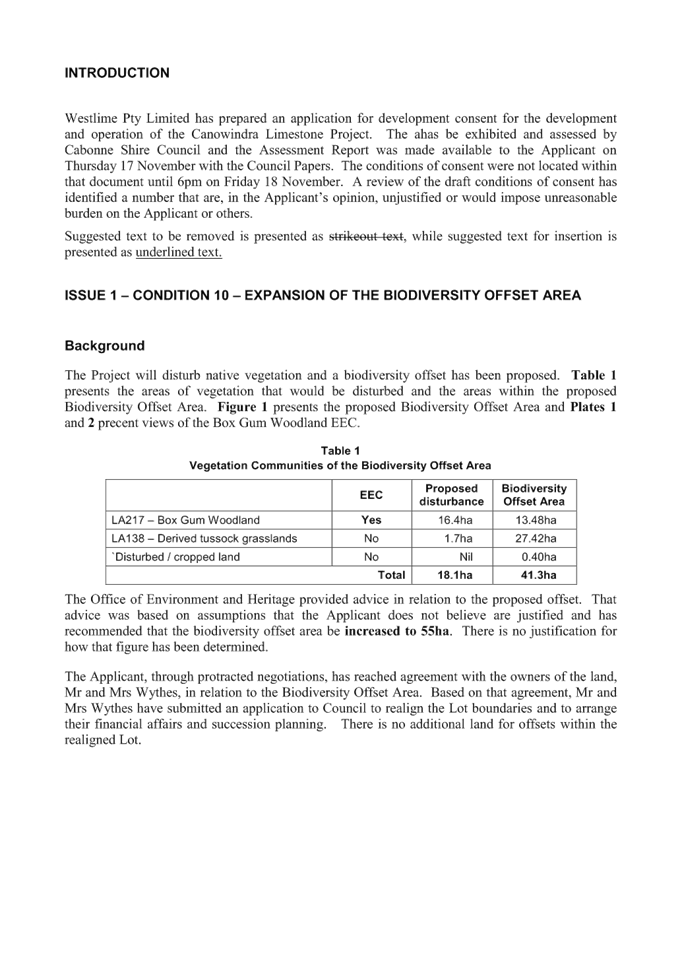
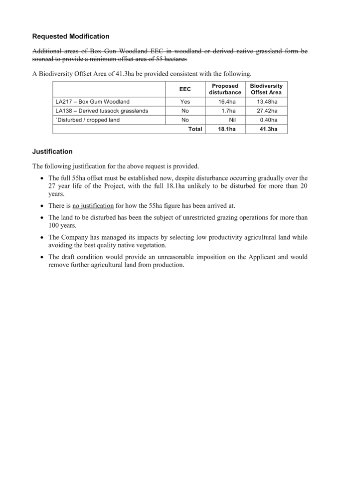
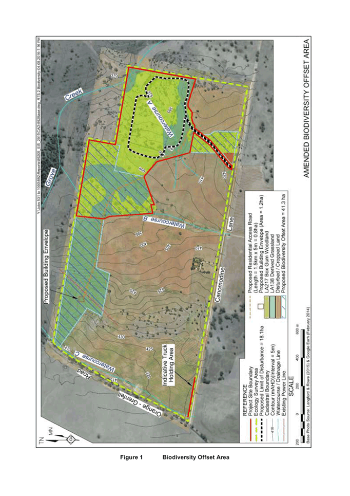
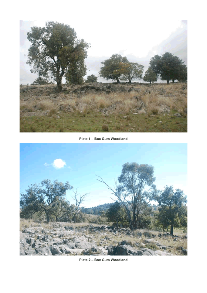
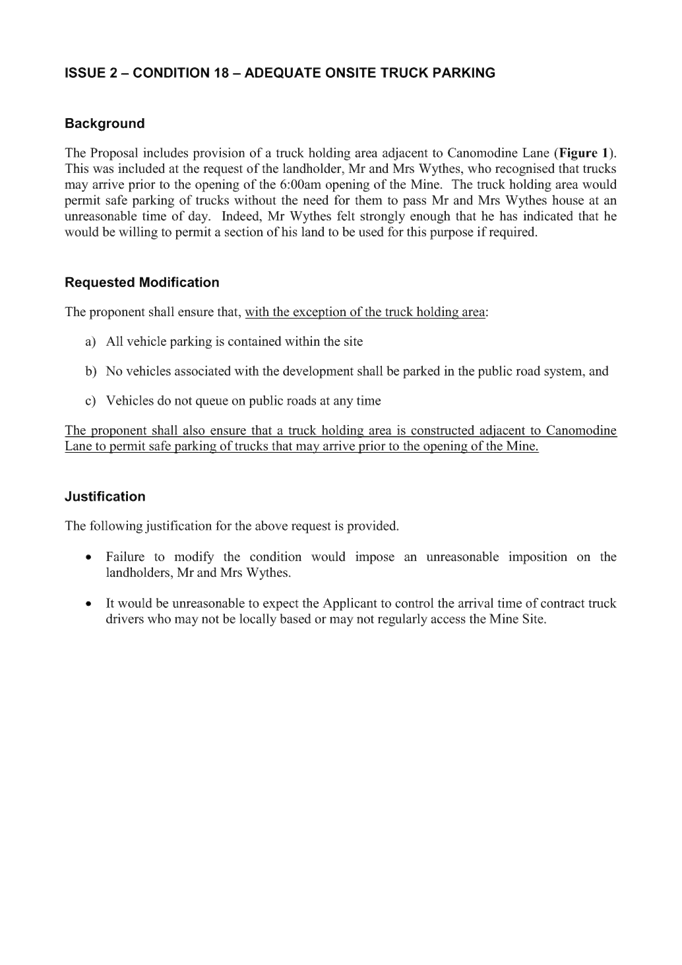
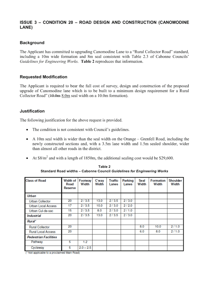

|
Item 24 Ordinary Meeting 20 December 2016
|
Item 24 - Annexure 1
|
DRAFT CONDITIONS OF
CONSENT
1. DEVELOPMENT IN ACCORDANCE WITH
PLANS
Objective
To ensure the
development proceeds in the manner assessed by Council.
Performance
Development is
to take place in accordance with the attached stamped modified plans (Ref:
Geolyse, proposed site plan, project number 216243, sheet TP03 of TP03 - marked
revision A) and documentation submitted with the application and subject to the
conditions below, to ensure the development is consistent with Council’s
consent.
The Principal
Certifying Authority for the project may request an application for
modification of this consent or a new application in the event that changes to
the approved plans are subsequently made. An application to modify the
development consent under s96 of the Environmental Planning and Assessment Act,
1979, as amended and will be subject to a separate fee.
2. LOT
DESIGN AND PURPOSE
Objective
To ensure the
subdivision proceeds in accordance with Council’s consent and that the
purpose of the newly created Lots are clarified in the context of Cabonne Local
Environmental Plan, 2012.
Performance
(a) Surveying of
the subject land will be generally in accordance with the attached draft plan
of survey.
(b) Lots 1, 2, 3,
and 4 have been approved under Clause 4.1(3) of the Cabonne Local Environmental
Plan, 2012.
3. APPLICATION
FOR CERTIFICATION
Objective
To satisfy the
post-consent requirements of this Development Consent, and to comply with
Section 109 of the Environmental Planning and Assessment Act 1979, as amended.
Performance
The person
having the benefit of this consent is required to apply for a:
AN ACCESS
CONSTRUCTION CERTIFICATE to satisfy the requirements of Condition 10
AN ACCESS
COMPLIANCE CERTIFICATE to satisfy the requirements of Condition 10
SUBDIVISION
CERTIFICATE to satisfy the requirements of Condition 4
4. REGISTRATION OF PLAN OF
SUBDIVISION
Objective
To ensure
compliance with Section 109C(1)(d) of the Environmental Planning and Assessment
Act 1979, as amended.
Performance
An application
for a Subdivision Certificate is to include three (3) copies of an original
Plan of Subdivision prepared by a Registered Surveyor to be lodged at Land and
Property Information.
5. ASSET PROTECTION ZONES –
RFS S100B Authority
Objective
The intent of
measures is to provide sufficient space and maintain reduced fuel loads so as
to ensure radiant heat levels of buildings are below critical limits and to
prevent direct flame contact with a building. To achieve this, the following
conditions apply
Performance
The existing
Asset Protection Zones (APZs) around the existing dwelling are to be maintained
as outlined within section 4.1.3 and Appendix 5 of ‘Planning for Bush
Fire Protection 2006’ and the NSW Rural Fire Service’s document
‘Standards for asset protection zones’.
6. WATER AND UTILITIES – RFS
S100B Authority
Objective
The intent of
measures is to provide adequate services of water for the protection of
buildings during and after the passage of a bushfire, and to locate gas and
electricity so as to not contribute to the risk of fire to a building.
Performance
The provision of
water, electricity and gas shall comply with section 4.1.3 of ‘Planning
for Bush Fire Protection 2006’.
7. ACCESS
– RFS S100B Authority
Objective
The intent of
measures for property access is to provide safe access to/from the public road
system for fire fighters providing property protection during a bush fire and
for occupants faced with evacuation.
Performance
Public road
access shall comply with 4.1.3(1) of ‘Planning for Bushfire Protection
2006’.
8. PROVISION
OF RURAL ADDRESS NUMBER
Objective
To provide each
eligible rural property with a rural address number in accordance with Standard
AS/NZS 4819:2011: Geographic Information – Rural and Urban addressing.
Performance
The location of
each eligible access will be established and a number allocated based upon
measurements taken by the Principal Certifying Authority which will be in
accordance with Standard AS/NZS 4819:2011.
The applicant is
to contact Council’s Environmental Services Department on 63923247 to
obtain an application form and instructions.
9. ERECTION
OF RURAL ADDRESS NUMBER
Objective
To ensure each
eligible rural property has a suitably erected and clearly visible rural
address number in accordance with Standard AS/NZS 4819:2011: Geographic
Information – Rural and Urban Addressing.
Performance
The designated
number plate(s) shall be obtained and erected in accordance with the
Specifications for Erection of Rural Address Numbers as supplied by
Council. (Note: These plates are available from
Council at the fee specified in Council’s Fees and Charges)
Written
notification is to be provided to Council indicating rural addressing number(s)
has/have been erected. This letter is to be supplied to Council or
Principal Certifying Authority PRIOR to the issue of a Subdivision Certificate.
10. PROVISION OF PRIVATE
ACCESS
Objective
To ensure that
safe and practical access is provided to the subject land.
Performance
Access must be
provided to all proposed lots in accordance with Council’s Provision of
Private Access Specification that is current at the time of application.
An Access
Construction Certificate must be obtained prior to commencement of construction
of any access or accesses to the property from the adjoining road.
A joint
inspection with the Principal Certifying Authority is to be held prior to
commencing construction of the access. Please telephone Council’s
Development Engineer on 6392 3247 to arrange a suitable date and time for the
inspection.
An Access
Compliance Certificate for the accesses must be submitted to Council before any
Subdivision Certificate can be issued for the development.
11. TRAFFIC AND
PEDESTRIAN MANAGEMENT PLAN
Objective
To ensure that
any traffic or pedestrian movement through or past the work site is safe.
Performance
The applicant is
to prepare and implement a Traffic Management Plan that provides necessary
direction to traffic or pedestrian movement through or past the work
site. The Traffic Management Plan is to be prepared by a suitably
qualified person in accordance with the provisions of the relevant Australian
Standards and is to be submitted to Council for approval PRIOR to its
implementation.
12. CONTRIBUTION
TO BUSHFIRE SERVICES
Objective
To make an
equitable contribution towards improvement of Bushfire Services and Amenities
for the specified Brigade. The contribution has been levied in accordance with
Councils Bushfire Service Contributions Plan, February, 1993.
A copy of this
Plan is available for inspection at Councils Department of Environmental
Services Bank Street, Molong during business hours.
Performance
The applicant
will make a contribution of $1,195.50 x 3 = $3,586.50 towards the improvement
of Bushfire Services and Amenities for The Ponds Brigade (Income No: 1032) to
Cabonne Council before any Subdivision Certificate can be issued for the
development.
13. ROAD
IMPROVEMENT CONTRIBUTION (SUBDIVISION)
Objective
To make
equitable contribution to address the impacts of development on Council
roads. The contribution has been levied to make improvements to the
stated road in accordance with Council’s Road Contributions Plan dated
April 2007, (General Rural Zone) or June 1993 (Rural Small Holdings Zone).
Performance
The applicant is
required to make a road improvement contribution of $16,413.50 towards the
improvement to Gowan Road (Income Number: 5321) to Cabonne Council before any
Subdivision Certificate can be issued for the development.
14. PROVISION OF POWER FOR SUBDIVISION
Objective
To ensure
financial equity in providing adequate power supply for newly created Lots 1, 2
& 4.
Performance
Prior to the
issuing of a Subdivision Certificate, the applicant will submit a Compliance
Certificate from the Electricity Authority indicating that adequate power
supply would be available to proposed Lots 1, 2 & 4 shall it be required.
15. COMPLIANCE WITH CONDITIONS OF CONSENT
Objective
To ensure the development
proceeds in the manner as determined by Council.
Performance
All conditions
of this consent are to be complied with to the standards specified prior to issue of a subdivision
certificate.
ADVISORY NOTE
Objective
Advisory
condition only where survey indicates the need for correction of the road
alignment.
Performance
In the event
that, during the course of the survey, it is found that part of a constructed
public road intrudes onto the subject property, the applicant will be required
to bear all survey costs which are common to that of the subdivision. Any
request to Council for reimbursement for additional survey costs which relate
directly to the road re-alignment should be direct council’s General
Manager.
|
Item 27 Ordinary Meeting 20 December 2016
|
Item 27 - Annexure 1
|
|
|
|
Agenda of Ordinary Meeting - 20 December 2016
|
|
|
{Instruction for Contaminated Land
Policy Template:
1 text
in {} brackets are advisory notes and must be deleted in the final Council
Specific policy.
2 text
in [] square brackets are statements that are considered optional in developing
your own council specific policy.
3 search
for { or [ to locate section to modify.
4 while
the final policy format and content will be up to each council to determine,
the more consistent policies are between councils the more effective they will
be in improving CLM across the whole region. Therefore it is highly recommended
that, with the exception of those statements identified as optional, the policy
be adopted as is.}
Addendum
May 2016
11.3 point 8 underground petroleum
storage system to Underground Storage tank
12.3.2 add condition 5 fencing and
erosion and sediment controls
17 correct regulation title
Appendix A add two historical land uses
for electrical switch gear and transformers and off site impacts from regulated
sites
Update Category 1 table of areas and
zones with Standard Instrument details
Addendum
September 2016
12.2 Addition considerations for
Category 1 remediation DAs
12.3.2 update condition 14, replace
condition 15 with condition 15, 16 and 17
12.5 add “report”
13.1 Clarify how reports may be assessed
and audited
14 Clarify Auditing requirements for
Tier 2 and 3 risk assessments
16 correct offence provisions for
unlawful waste facility
17 Add reference to planning
considerations for UPSS regulation
Appendix A Minor edits and identify
Table 1 activities
Appendix B Clarifying statements on how
standard wording is to be used
Update standard conditions for
· Remediation
Action Plans,
· Validation,
· Site
Management Plans
· Site
Audit Statements
· Category
1 remediation conditions 1, 3, 7, 8, 9, 18, 20
Additional conditions around
· Where
evidence of contaminating activity is to be destroyed
· Ongoing
site management
Appendix C Amendments to Summary Report
Template
Table of Contents
{Instruction
for Contaminated Land Policy Template: 2
Table
of Contents. 3
1 Preamble. 5
2 Policy
Objectives. 6
3 Application. 6
4 Policy
Statement. 7
5 Abbreviations. 7
6 Glossary. 8
7 Legislation. 12
8 Potentially
contaminating land uses. 13
9 Information
management. 13
9.1 Contaminated Land Information System
definition. 13
9.2 What the information is used for. 14
9.3 Including or removing land from
Council’s CLIS. 14
9.4 Land Contamination Investigation
Status. 15
9.5 Provision of information. 16
9.6 Information provided on the s149
planning certificate. 17
10 Rezoning. 21
11 Development
Applications. 22
11.1 Pre Development Application
Meetings. 22
11.2 Development Assessment
consideration of contamination. 23
11.3 Triggers for preliminary site
investigation. 25
11.4 Conditions of consent requiring
remediation. 25
11.5 Unexpected findings protocol 25
12 Remediation. 26
12.1 Remediation Overview and SEPP 55. 26
12.2 Category 1 remediation (requires
consent). 26
12.3 Category 2 remediation (carried out
without consent, SEPP 55). 29
12.3.1 Notification. 29
12.3.2 Conduct of remediation. 29
12.4 Underground Storage Tanks and
Underground Petroleum Storage Systems. 32
12.5 Validation reports and Notice of
completion of remediation. 32
13 Contaminated
Land Consultants. 33
13.1 Reports. 33
13.2 Certification of consultant. 34
13.3 Insurance. 34
13.4 Summary Report. 34
14 Site
Auditing. 35
15 Site
Management Plans. 36
16 Contaminated
land standards for pollution. 36
17 The
Protection of the Environment Operations (Underground Petroleum Storage System
(UPSS) Regulation (2014) enforcement. 37
Appendix
A - potentially contaminating land uses. 39
Appendix
B Standard Conditions of Consent. 43
Development
Applications for contaminated sites. 43
Request
for information: 43
Site History. 43
Preliminary investigations. 43
Detailed investigations. 43
Deferred
Commencement or prior to Construction Certificate: 43
Remediation Action Plans. 44
Validation. 44
Environmental or Site Management Plans. 44
Site Audit Statement. 45
Category
1 remediation: 45
Appendix
C Summary Report Template. 49
1 Preamble
Contaminated
land is managed by Council to minimise the impacts of past land use on the
orderly development of land in the future. Land may have become contaminated by
actions in the past when issues around contamination, pollution and waste
management were not considered important by the community and the long-term
effects of some chemicals on the environment and human health were poorly
understood.
The
Environment Protection Authority (EPA) is the State body that regulates
contaminated land under the Contaminated Land Management Act 1997;
however Council has responsibility to ensure that when exercising its statutory
planning functions in relation to the development of contaminated land, all the
relevant information is considered.
To
do this Council must:
• Consider
the likelihood of land contamination as early as possible in the planning and
development control process;
• Link
decisions about the development of land with the information available about
contamination possibilities;
• Adopt
a policy approach which will provide strategic and statutory planning options
based on the information about contamination; and
• Exercise
statutory planning functions with a reasonable standard of care.
This
policy is made to guide Council on how it will carry out its planning
functions, and to provide a local context for decision making in relation to
contaminated land. This policy is intended to supplement, and should be
read together with, the Managing Land Contamination Planning Guideline
(1998) with reference to Part 7A of the Environmental Planning and
Assessment Act 1979.
It
is expected that the reader of this policy will be familiar with the general
contaminated land management framework that is set out in the Managing Land
Contamination Planning Guideline (Department of Urban Affairs and Planning
and EPA 1998), State Environmental Planning Policy 55 Remediation of Land
(SEPP 55), the National Environmental Protection (Assessment of Site
Contamination) Measure 1999, and other applicable legislation.
This
policy sets out the local requirements for {insert Council Name}
and must be read in conjunction with the other documents mentioned. Further
information about the general principles of contaminated land management and
how Council’s policy may relate to the sale or redevelopment of your land
may be found on {insert appropriate website}.
This
policy is based on the Central West Councils Regional Contaminated Land Policy
Template, developed with assistance from the New South Wales Government through
the EPA’s Contaminated Land Management Program under funding by the NSW
Environment Trust.
2 Policy
Objectives
The
objectives of the policy are to describe how Council will keep relevant
records, provide information to interested parties and make decisions regarding
contaminated land. Specifically this policy will describe how:
· Information
about potentially contaminated land is collected;
· Information
is to be maintained in a Contaminated Lands Information System (CLIS);
· Council
will use information to appropriately manage the use of land and what information
is required for the development of the land;
· Information
will be provided to owners of affected land and the public;
· Information
will be provided on s149 planning certificates;
· Council
should be notified of remediation activities within it LGA;
· Clarify
where Category 1 remediation activities will be identified;
· how
remediation activities should be conducted;
· Consultants
should report on contaminated sites;
· A
Site Audit Statement may be required;
· A
Site Management Plan will be enforced;
· Council
will use contaminated land standards and principles to address illegal land
filling;
· The
UPSS (Underground Petroleum Storage System) Regulation is to be administered by
Council.
3 Application
This
policy applies to all land within the [insert
Council name] Local Government
Area and includes:
1 Where
Council is duly exercising one of the following planning functions:
a. Preparation
of a planning proposal;
b. Processing
and determination of a development application or the modification of a
development consent;
c. Processing
and determination of an application for a complying development certificate;
and
d. Furnishing
of advice in a certificate under section 149; or
2 Where
Council is:
a. Investigating
or remedying illegal land filling; or
b. Administering
the Protection of the Environment (Underground Petroleum Storage System)
Regulation 2012.
Note:
the functions described in paragraph 2 above are not 'planning functions' to
which Council is afforded protection from liability under section 145B of the
EP&A Act.
4 Policy
Statement
Where
Council is aware of any past or present potentially contaminating land uses or
activities (as described in this policy) it will maintain relevant information
about the land on which that use or activity occurred or is occurring to
ensure:
· That
land owners and other interested parties may be made aware of those uses; and
· Council
can assess land contamination issues and monitor remediation under State
Environmental Planning Policy 55 Remediation of Land (SEPP 55).
The
information held is intended to aid decision-making regarding contaminated land
investigations, land use planning and determinations.
This
policy will restrict the use of land by:
1 Prescribing
the circumstances where land is required to undergo some level of assessment
for land contamination, or remediation, before consent can be granted for any
development on that land or the land can be rezoned; and
2 Enforce
the restrictions that, in the opinion of the consultant or auditor, are required
through the imposition of a Site Management Plan that may be imposed on the
land following remediation.
Council
will set standards for the conduct of remediation and reporting of contaminated
land matters to ensure that contamination and remediation can be effectively
managed and monitored for the benefit of the community.
While
Council will endeavour to develop and maintain a comprehensive collection of
relevant information, it does not guarantee the completeness or accuracy of all
the information held. To the degree that information is not required to be
provided to Council or hitherto has not been required to be kept by Council,
Council may not be in possession of all the relevant information for any given
property at any given time.
5 Abbreviations
CLIS Contaminated
Land Information System
CLM Contaminated
Land Management
CLM
Act Contaminated Land Management Act 1997
DA Development
Application
DSI Detailed
Site Investigation
EPA NSW
Environment Protection Authority
EP&A
Act Environmental Planning and Assessment Act 1979
EP&A
Reg Environmental Planning and Assessment Regulation 2000
EPI Environmental
Planning Instrument
LEP Local
Environment Plan
NEPM National
Environmental Protection (Assessment of Site Contamination) Measure 1999
POEO
Act Protection of the Environment Operation Act 1997
PSI Preliminary
Site Investigation
RAP Remediation
Action Plan
SAS Site
Audit Statement
SEPP
55 State Environmental Planning Policy
55 Remediation of Land
SMP Site
Management Plan
UPSS Underground
Petroleum Storage System
UST Underground
Storage Tank
6 Glossary
Assessment of site
contamination A formal investigation
and report carried out by a contaminated land consultant in accordance with the
Planning Guideline, the Reporting Guidelines or the UPSS Regulation and may
include a preliminary site investigation, a detailed site investigation, a
remediation action plan or a validation report.
Category 1
remediation As
defined in SEPP 55, being remediation that requires development consent.
Category 2
remediation As
defined in SEPP 55, being remediation that may be undertaken without
development consent.
Contaminated Land
Management In regard to
Council’s responsibilities: The management of records relating to past or
present land use, assessment of site contamination, provision of relevant
information, monitoring of remediation and the determination of suitability for
rezoning and development consents as described within this policy.
Contamination As
defined in EP&A Act: contaminated land means land in, on or
under which any substance is present at a concentration above the concentration
at which the substance is normally present in, on or under (respectively) land
in the same locality, being a presence that presents a risk of harm to human
health or any other aspect of the environment.
or
in CLM Act: Contamination of land, for the purposes of this Act,
means the presence in, on or under the land of a substance at a concentration
above the concentration at which the substance is normally present in, on or
under (respectively) land in the same locality, being a presence that presents
a risk of harm to human health or any other aspect of the environment.
Note:
Contamination and Pollution have similar statutory definitions, and while
Council has statutory powers to regulate pollution (in particular under the Protection
of the Environment Operations Act 1997) this policy is primarily concerned
with contamination. A pollution incident is considered to be a matter that is
dealt with in the short term by the relevant powers. Pollution can result in
contamination if the pollution is not cleaned up in the short term or Council
does not become aware of the issue within a reasonable time to be able to
enforce a suitable remedy.
Contamination
assessment See
Assessment of site contamination.
Deferred Commencement A
development consent is granted subject to a condition that the consent is not
to operate until the applicant satisfies the consent authority as to any matter
specified in the condition, in accordance with s 80 (3) of the Environmental
Planning and Assessment Act 1979.
Detailed Site
Investigation Stage
2 – Detailed Investigation as defined in Planning Guideline, the
Reporting Guidelines and the NEPM. An investigation that will define with high
precision the nature, extent and risks posed by contamination.
Environmental
Management Plan See Site Management
Plan.
Phase A
term commonly used to refer to the formal stages of contamination assessment;
however, it is not reliably consistent with the terms defined in this policy.
Planning Guideline Managing
Land Contamination Planning Guideline (Department of Urban Affairs and
Planning and EPA 1998) or otherwise specified by s 145C Environmental
Planning and Assessment Act 1979.
Pollution As
defined in POEO Act
pollution means:
a water pollution, or
b air pollution, or
c noise pollution,
or
d land pollution.
pollution incident means an incident or set of
circumstances during or as a consequence of which there is or is likely to be a
leak, spill or other escape or deposit of a substance, as a result of which
pollution has occurred, is occurring or is likely to occur. It includes an
incident or set of circumstances in which a substance has been placed or
disposed of on premises, but it does not include an incident or set of
circumstances involving only the emission of any noise.
land pollution or pollution of land means placing in
or on, or otherwise introducing into or onto, the land (whether through an act
or omission) any matter, whether solid, liquid or gaseous:
a that causes or is likely to
cause degradation of the land, resulting in actual or potential harm to the
health or safety of human beings, animals or other terrestrial life or
ecosystems, or actual or potential loss or property damage, that is not
trivial, or
b that is of a prescribed
nature, description or class or that does not comply with any standard
prescribed in respect of that matter, but does not include placing in or on, or
otherwise introducing into or onto, land any substance excluded from this
definition by the regulations.
See note under contamination.
Preliminary Site
Investigation Stage
1 – Preliminary investigation as defined by the Planning Guideline, the
Reporting Guidelines and the NEPM. An investigation that defines the
potentially contaminating activities carried out on a site, the areas where
contamination is most likely to exist and, if necessary, sufficient soil or
groundwater sampling to confirm whether the land has been contaminated or not.
Reporting Guidelines Guidelines
for Consultants Reporting on Contaminated Sites (EPA 1997 updated 2011).
Remediation As
defined in SEPP 55 remediation means:
a. removing,
dispersing, destroying, reducing, mitigating or containing the contamination of
any land, or
b. eliminating
or reducing any hazard arising from the contamination of any land (including by
preventing the entry of persons or animals on the land).
Remediation Action
Plan Stage
3 – Site Remediation Action Plan as defined by the Planning Guideline and
the Reporting Guidelines. A plan that sets out how a contaminated site can be
made suitable for its intended use including methodology, clean-up criteria and
validation procedures.
s149 planning
certificate A
planning certificate as defined under section 149 of the EP&A Act.
Site Audit Non
Statutory Site Audit means a site audit undertaken by a site auditor that
is not a requirement of a statutory instrument such as a development consent or
regulation by the Contaminated Land Management Act (1997).
Statutory
Site Audit as defined in section 47 of the Contaminated Land Management
Act (1997) means a site audit carried out in order to secure compliance with,
among other things, a requirement of SEPP55 or a development consent.
Site
Audit Statement contains the Site Auditor’s findings and is in the
form approved by the EPA. See s53B CLM Act.
Further information about Site Audits can be found in the NSW EPA website: http://www.epa.nsw.gov.au/clm/auditorscheme.htm
Site Management Plan A
plan that is intended to manage residual contamination following suitable
remediation of a site.
Specific
potentially contaminating A land use
specified in Appendix A that will, if determined to
land use have
been carried out on the land, be used to identify land for contaminated land
management under this policy.
Suitably qualified
person Means
a person who has such competence and experience in relation to the assessment
of site contamination as is recognised as appropriate by the contaminated land
management industry. They will also be, or be reasonably able to be, or
supervised by a consultant who is, certified under a contaminated land
consultant certification scheme recognised by the EPA.
UPSS regulation Protection
of the Environment Operations (Underground Petroleum Storage Systems)
Regulation 2014
Validation Report Stage
4 – Validation and monitoring as defined by the Planning Guideline and
the Reporting Guidelines. A report detailing the results of the
post-remediation testing against the clean-up criteria stated in the RAP.
7 Legislation
Contaminated
Land Management Act 1997
Provides for Site Auditing (s47), and
specific requirements for 149 planning certificates in relation to the Act
(s59).
Environmental
Planning and Assessment Act 1979
Provides the basis of the planning
system in NSW and permits the creation of State Environmental Planning
Policies. Part 7A specifically details the liabilities for Planning Authorities
in respect of contaminated land and defines the contaminated land Planning
Guideline.
Environmental
Planning and Assessment Regulation 2000
Sets
out the requirements for s149 planning certificates (Schedule 4).
National
Environmental Protection (Assessment of Site Contamination) Measure 1999.
Sets
a national standard for contaminated site assessment.
Protection
of the Environment Operations Act 1997
Enables
the EPA, and Councils, to regulate pollution and waste in NSW.
Protection
of the Environment Operations (Waste) Regulation 2014
Regulation
of waste in NSW.
Protection
of the Environment Operations (Underground Petroleum Storage Systems)
Regulation 2014
Self-regulation
regime of underground fuel storage in NSW
State
Environmental Planning Policy No 55-Remediation of Land
Establishes
the mandatory considerations for consent authorities when considering
development applications in relation to contaminated land, and criteria for
remediation of land before development can occur.
{Local
Environment Plan for LGA}
8 Potentially
contaminating land uses
This
policy will identify those land uses that have a reasonable potential to result
in land contamination that may need to be addressed during development.
The
list of land uses and activities that this policy will specifically identify as
having the potential to result in land contamination are in Appendix A. These
land uses have the potential to cause land contamination because of the
materials typically used, processed or stored on-site, the generation of
contaminating waste products or the use of thermal processing.
In
addition, the storage of significant volumes of petroleum or chemicals or
activities involving the maintenance of motor vehicles or mechanical plant will
be considered to be potentially contaminating land uses.
Where
a property has been identified as having been associated with one or more of
these land uses or activities, it will be included in the Contaminated Land
Information System so that relevant information can be recorded and used for
the purpose of this policy.
9 Information
management
Note:
Council’s records and classifications are not intended to reflect the
risk of harm to human health or the environment for a property in its current
state or by its current land use. Where there are concerns that need to be
addressed in the short term, the Council should use its powers under the Protection
of the Environment Operations Act 1997 or refer the matter to the EPA.
9.1 Contaminated Land Information System definition
Council
will maintain a Contaminated Land Information System (CLIS) to record relevant
information regarding land, its historical uses and activities carried out on
it, assessments for contamination, remediation and Site Audits.
Information
pertaining to a specific location shall include:
· Current
and historical property description;
· Historical
land uses or activities that have the potential to contaminate (See Appendix
A);
· The
land contamination investigation status;
· Reports
and notices relating to contamination assessment;
· Reference
to and brief comments relating to development applications, development
consents, planning proposals to rezone land approved (or refused on the basis
of contamination-related issues) and complying development certificates;
· Site
Audit Statements; and
· EPA
correspondence.
The
information will not include personal information except personal information
that is included in an assessment report.
9.2 What the information is used for
The
information held in the CLIS will be used for the purpose of fulfilling the
policy statement (see Section 4 Policy Statement above).
Specifically
the information will be used to:
· Provide
information on s149 planning certificate;
· Inform
development applications, modification applications, complying development
certificate applications and assessments, including pre-DA meetings and
assessment;
· Inform
strategic planning and the preparation of Planning Proposals;
· Monitor
and regulate remediation of contaminated land; and
· Administer
the UPSS regulation.
9.3 Including or removing land from Council’s CLIS
Land
is included in the CLIS based primarily on information known to Council
regarding land use and does not necessarily reflect whether the land is
actually contaminated or not. Land will be identified on the CLIS if Council:
· Holds
records, or is aware, that the land has been used for a potentially
contaminating land use as defined in Appendix A;
· Has
carried out an inspection that suggests the land is likely to have been
affected by contamination, pollution, landfilling, or by being used in an
environmentally unsatisfactory manner (refer to definitions in the POEO Act);
· Is
aware that the land has been the subject of remediation;
· Believes
the land could have lawfully been used for a purpose listed in Appendix A and
has no evidence to the contrary; or
· Is
aware that the land is, or has been, zoned for industrial purposes.
Any
land where a new development is commenced, whether approved by Council, subject
to a Complying Development Certificate or exempt development, that is
consistent with land uses defined in Appendix A will be included on the CLIS
when Council becomes aware of it.
Land
will not be included where:
· The
use is at a domestic scale;
· The
land use is clearly operated at a scale that is unlikely to cause land
contamination; or
· The
activity is, and has always been, generally of a retail or warehousing nature
provided that any fuels, oil and chemicals remain in sealed containers from the
manufacturer and are not dispensed or decanted into other containers; and,
·
Council is not otherwise aware that the land is likely to be contaminated.
Note:
It is acknowledged that both agricultural and residential land can be subject
to incidental contamination and that, in some circumstances, could give rise to
a risk to human health and the environment, however it is considered
unreasonable to apply this policy where there is no evidence of circumstances
presenting such a risk. Areas of agricultural land such as fuel storages and
stock dips will be considered for contamination assessment when a DA is
received however the whole land parcel will not be included in the CLIS unless
specific reports are provided to Council.
[A maximum of three land use descriptors will apply to each
record.]
[When land is added to the CLIS the owner will be notified.]
As
it is a requirement that Council review its records every time it issues a s149
planning certificate and considers land contamination before determining a
development application, a record of land must not be removed from the CLIS
unless Council is satisfied that the information held does not relate to the
land, or that any potentially contaminating activity has not taken place on the
land.
Where
land is subdivided or consolidated, information about the former land uses on
the land will be carried onto the new property description(s).
9.4 Land Contamination Investigation Status
To
assist Council to monitor and communicate the level and quality of information
about contamination on any land parcel, each parcel on the CLIS will be
classified according to the significance of the information the Council holds
about the parcel. Each parcel on the CLIS will be classified into one of five
classifications:
Table
1. Contaminated site investigation status classification
|
Investigation
Class
|
Description
|
|
A
- Identified
|
· Council has
identified that the land should be included on the CLIS because a potentially
contaminating land use is known to have been undertaken (Appendix A), but the
results of any formal investigation have not been provided to Council.
· At this status, it
is not possible to determine if land could be suitable for any particular use.
|
|
B
- Assessed
|
· Council has been
provided with a contamination assessment report or other documentation
indicating that the land is (or has been) contaminated, but is not satisfied,
based on information provided in contamination assessment reports, that the
land is suitable for any specific land uses and, therefore, further
consideration of investigation, remediation or validation is required to
determine a relevant application. Reports may indicate that the land may be
suitable for some uses with conditions such as limited depth of excavation or
contamination remaining in inaccessible areas due to existing structure etc.
· For any land
adjacent to identified potentially contaminated land where a contamination
assessment report received by Council has identified that contamination has
migrated to the adjoining land will be classified as assessed.
|
|
C
– Site Management Plan
|
The
land has been remediated, however, is subject to a site management plan
(SMP). Any new DA must consider the requirements of a SMP that applies to the
land.
|
|
D
- Suitable for Limited Uses
|
· Council has been
provided with a contamination assessment report or other documentation
indicating that the land is (or has been) contaminated, but is satisfied,
based on information provided in contamination assessment reports, that the
land is suitable for some specific land uses without conditions.
· Further
consideration of investigation, remediation or validation would be required
to determine a relevant application for more sensitive land uses.
|
|
E
- Unrestricted
|
Council
is satisfied based on information provided in contamination assessment
reports that the land is suitable for all land uses and, therefore, no
further investigation is required to determine a relevant application. This category
shall only be used where no further assessment of contamination is required
to determine the suitability of any permissible DA.
|
The
land contamination investigation status classification does not necessarily
indicate that land is or is not contaminated but indicates whether or not
appropriate information is available to make a decision in respect of the land.
Whenever
new information about a land parcel or property is received by Council, the
status classification should be reconsidered and changed if necessary.
If
contamination investigations standards change, it should be considered whether
any land with a status class of “E – Unrestricted” should
have its status changed. If investigation thresholds are reduced it may be
appropriate that all “D - suitable for limited uses” and “E
– Unrestricted” statuses be changed to “B - Assessed”
until a thorough review of each assessment report can be carried out.
9.5 Provision of information
Information
on the CLIS may be provided to any person in the form of an s149 planning
certificate in accordance with the EP&A Act.
Otherwise,
a person with a valid interest may seek to view:
1 The
CLIS register information; and
2 Reports
held by Council.
However,
due to Council’s privacy policy or copyright restrictions (and the
legislative requirements of Government Information (Public Access) Act 2009
and Privacy and Personal Information Protection Act 1998), Council may
not be able to provide all information it holds.
A
person with a valid interest may include the following people in respect of the
relevant land:
1 The
owner;
2 The
owner of neighbouring land;
3 State
Government agencies such as the NSW Environment Protection Authority;
4 Contaminated
land consultants investigating the land or neighbouring land;
5 Utilities
providers;
6 Conveyancers
acting on behalf of the owner; or
7 With
the owner’s permission:
a. A
potential purchaser;
b. A
purchaser’s conveyancer; or
c. A
real estate agent.
The general
release of information on the CLIS is not considered to be in the public
interest.
9.6 Information provided on the s149 planning certificate
S149
planning certificates provide a range of information regarding the rights and
restrictions placed on a parcel of land.
Council
is obliged to provide certain information on the s149 planning certificate as
specified in Schedule 4 of the Environmental Planning and Assessment
Regulations 2000 and s59 of the Contaminated Land Management Act 1997. That
is:
1 Clause
7, Schedule 4 of the Environmental Planning and Assessment Regulations 2000
requires that the certificate identify whether or not the land is affected by
any policy (adopted by Council or by a public authority for the express purpose
of its adoption being referred to in s149 certificates issued by Council) that
restricts the development of land because of the likelihood of any risk.
Information pertinent to clause 7 are noted in 1A and 1B below; and
2 Section
59 of the Contaminated Land Management Act 1997 requires that the
certificate address the specific matters relating to the management of
contaminated land set out in that section. Information pertinent to s59 is
noted in 2A and 2B below.
This
Policy intends to be an adopted policy of the kind referred to in numbered
paragraph 9.6, 1. above, that restricts the development of land because of the
likelihood of contamination risk as set out in the Policy Statement (Section 4.
above).
The
following wording will be used for each Contamination Investigation Status and
where other relevant information is known about the land:
1A Notation
to be included on s149 planning certificate issued under
s149(2), as required by Clause 7, Schedule 4 of the EP&A Reg –
adopted policies that restrict the development of the land because of the
likelihood of any risk:
• Land
not considered to require restriction under this policy
Council’s
adopted Contaminated Land Policy does not place any specific restriction on the
land to which this certificate relates at this time.
• Land
classed as “A - Identified”
The land to
which this certificate relates has been used for purposes that have the
potential to contaminate land. Council records do not have sufficient
information to determine whether the land is contaminated. Council’s
adopted Contaminated Land Policy restricts the development on the land by
requiring that the land undergoes some level of assessment for land
contamination, and/or remediation if required, where zoning changes are
proposed or consent is required for the carrying out of any development.
Council’s adopted policy provides information on how these restrictions
will be applied in accordance with provisions under relevant State legislation.
It is recommended that persons relying on this certificate undertake their own
assessment of the land’s suitability for purposes that do not require
development consent.
• Land
classed as “B - Assessed”
The land to
which this certificate relates has been used for purposes that have the
potential to contaminate land. Council’s adopted Contaminated Land Policy
restricts the development on the land by requiring that the land undergoes some
level of assessment for land contamination, and/or remediation if required,
where zoning changes are proposed or consent is required for the carrying out
of any development. Council’s adopted policy provides information on how
these restrictions will be applied in accordance with provisions under relevant
State legislation. It is recommended that persons relying on this certificate
undertake their own assessment of the land’s suitability for purposes
that do not require development consent.
• Land
classed as C - Site Management Plan
The land to
which this certificate relates has been used for purposes that have the
potential to contaminate land. Council has been advised that the site has
undergone some remediation of site contamination; however, remains subject to a
site management plan to mitigate the risk posed by land contamination on the
land. The site management plan may place restrictions on development or use of
the land and may include ongoing obligations by the owner or occupier.
Council’s adopted Contaminated Land Policy restricts the development of
the land by ensuring compliance with the applicable site management plan.
Further investigation may be required where zoning changes are proposed or
consent is required for the carrying out of any development. Council’s adopted
policy provides information on how these restrictions will be applied in
accordance with provisions under relevant State legislation. It is recommended
that persons relying on this certificate undertake their own assessment of the
land’s suitability for purposes that do not require development consent.
• Land
classed as D - Suitable for Limited Uses
The land to
which this certificate relates has been used for purposes that have the
potential to contaminate land. An assessment of site contamination has
recommended that the land is suitable for certain types of use. Council’s
adopted Contaminated Land Policy restricts the development on the land by
requiring that the land undergoes some level of assessment for land
contamination, and/or remediation if required, where zoning changes are
proposed or consent is required for the carrying out of development not
consistent with the assessment of site contamination recommendations.
Council’s adopted policy provides information on how these restrictions
will be applied in accordance with provisions under relevant State legislation.
It is recommended that persons relying on this certificate undertake their own
assessment of the land’s suitability for purposes that are not consistent
with the assessment of site contamination recommendations and do not require
development consent.
• Land
classed as E - Unrestricted
The land to
which this certificate relates has been used for purposes that have the
potential to contaminate land. An assessment of site contamination has
recommended that the land is suitable for all types of use.
1B Notation
to be included on s149 planning certificates issued under s149(5) of the
EP&A Act – advice on such other relevant matters affecting the
land of which Council may be aware.
• Where
the site is known to be subject to the UPSS regulation as regulated by Council
The land is
subject to the Protection of the Environment (Underground Petroleum Storage
System) Regulation 2014.
• Where
the land has been used for specific purposes listed in this policy
The land has
been used for the following purposes:
(see list from
Appendix A for potentially contaminating land uses and activities that
may be listed).
• Where
Council is in possession of contamination assessment reports
Council has one
or more reports on the assessment of site contamination.
{Where Council
is able to provide investigation results or summaries of results held by
Council without disclosing confidential information it should do so as part of
the planning certificate.}
• Where
Council is in possession of a Site Audit Statement
Council has a
site audit statement.
{this is a
duplication in terms of the CLM Act s59 requirements for s149(2) requirements
however the Planning Guideline recommends a copy of the site audit
statement should be attached to s149(5).}
{Where Council
is able to provide a copy of the site audit statement with the planning
certificate it should do so.}
• Where
remediation has been approved in accordance with SEPP55
Development
consent has been granted to carry out Category 1 Remediation on the land.
• Where
remediation has been notified in accordance with SEPP55
Council has been
notified that Category 2 remediation is to be carried out on the land.
2A Notation
to be included on s149 planning certificate issued under s149(2) of the
EP&A Act, as required by s59(2) of the CLM Act
• Where
Council has received a Site Audit Statement that relates to the land
Council has
received a Site Audit Statement that relates to the land.
• Where
the site has not been regulated by the CLM Act
The land to
which this certificate relates is not presently subject to regulation under the
Contaminated Land Management Act 1997.
• Where
the site has been declared significantly contaminated under the CLM Act
The land to
which this certificate relates is significantly contaminated land under the
Contaminated Land Management Act 1997.
• Where
the site is subject to a management order under the CLM Act
The land to
which this certificate relates is subject to a management order under the
Contaminated Land Management Act 1997.
• Where
the land is subject to a voluntary management proposal under the CLM Act
The land to
which this certificate relates is subject to an approved voluntary management
proposal under the Contaminated Land Management Act 1997.
• Where
the land is subject to an ongoing maintenance order under the CLM Act
The land to
which this certificate relates is subject to an ongoing maintenance order under
the Contaminated Land Management Act 1997.
2B Notation
to be included on s149 planning certificates issued under s149(2) of the
EP&A Act, as required by section 59(3) of the CLM Act
• Where
the land has been, but is no longer declared significantly contaminated
under the CLM Act
The land to
which this certificate relates was,
but is no longer significantly contaminated land under the Contaminated Land
Management Act 1997.
• Where
the land has been, but is no longer subject to a management order under
the CLM Act
The land to
which this certificate relates was,
but is no longer subject to a management order under the Contaminated Land
Management Act 1997.
• Where
the land has been, but is no longer subject to a voluntary management proposal
under the CLM Act
The land to
which this certificate relates was, but is no longer subject to an approved
voluntary management proposal under the Contaminated Land Management Act 1997.
• Where
the land has been, but is no longer subject to an ongoing maintenance order
under the CLM Act
The land to
which this certificate relates was, but is no longer subject to an ongoing
maintenance order under the Contaminated Land Management Act 1997.
10 Rezoning
The
rezoning of land is controlled by Part 3 Division 4 of the EP&A Act. A
planning proposal is prepared by the Council and submitted for consideration
and determination by the Minister (gateway determination). A gateway
determination will determine what further studies may be required.
Clause
6 of SEPP 55 has the effect of requiring the consideration of contamination
before preparing a planning proposal that would have the effect of zoning or
rezoning land. In order to assess the potential for land contamination,
Council will need a thorough land use history for the site with reference to
the potentially contaminated land uses and activities defined in this policy.
Preliminary
Site Investigations may be required prior to the preparation of the planning
proposal if such an investigation can reasonably be carried out. A planning
proposal may also recommend that further contamination investigations are
carried out.
Council
must have regard to a Preliminary Site Investigation, where such an
investigation has been carried out or it is practicable that such an
investigation can be carried out, before making a planning proposal where:
1 The
land is declared significantly contaminated land under Part 3 of the CLM Act;
2 An
activity referred to in Appendix A is being carried out on the land;
3 Council’s
records show that an activity or use referred to in Appendix A has been carried
out on the land; or
4 Council
has incomplete records about the use of the land, and the land is proposed to
be used for residential, educational, recreational, childcare or hospital
purposes (either as a dominant or ancillary use), and during the periods not
covered by those records it would, according to the uses formerly permitted on
the land, have been lawful to carry out an activity referred to in Appendix A.
If a
planning proposal proposes to change a land use zone in a local environmental
plan:
1 For
a particular parcel of land, it would not be appropriate to proceed with the
planning proposal unless the land was proven suitable for all kinds of
development that would be permitted in the new zone or for the development
contemplated in the planning proposal or it could be demonstrated that the land
could, and would, be remediated to make the land suitable; or
2 For
a large area of land (Generalised Rezonings), the planning proposal should seek
to adopt measures in the local environmental plan or development control plan
to ensure that the potential for contamination and the suitability of the land
for any proposed use are assessed before any development consent within the
rezoned land is granted.
If a
preliminary site investigation indicates that contamination would make land unsuitable
for particular uses, and:
1. The
land may be appropriately remediated for those uses, provisions are needed in
the local environmental plan or development control plan to require the
remediation before those uses can occur.
2. Where
remediation may not be appropriate for those uses, either the planning proposal
should not proceed or the range of permissible uses should be restricted in the
local environmental plan for that land use zone; that is, the land use options
should be reconsidered.
Information
on contamination possibilities can be used to locate uses according to land
suitability, for example, sensitive uses only being allowed in areas of low
contamination probability.
{Council should include this information in its policies, DCP or
instructions relating to rezoning and planning proposals}
11 Development
Applications
11.1 Pre Development Application Meetings
A
pre DA meeting may be held between Council staff and a potential applicant to
discuss the matters that need to be considered under heads of consideration
(s79C EP&A Act), the Local Environment Plan and the Development Control
Plan for the Council. [Please refer to
information about pre DA meetings on Councils website.]
A
pre DA meeting is not a planning function covered by Part 7A of the EP&A
Act, and any advice provided regarding land contamination matters is subject to
the same limitations and liabilities as any other advice provided in a pre DA
meeting.
Council’s
advice in a pre DA meeting should acknowledge:
1 That
the potential for land contamination must be considered for each and every
development application;
2 That
any pre-existing reports, studies or site audit statement need be considered in
terms of the specific development proposal;
3 Whether
or not the pre-existing reports or studies will meet the reporting requirements
of the Council at the time the development application is lodged.
After
acknowledging the factors above, Council may be able to provide advice as to
whether any further site assessment is required in order to assess the specific
proposal. However, Council may not prejudice the assessment of suitability of
the site for that proposed use.
The
provisions of the Development Assessment section 11.2 below may be applied
regardless of any advice provided during any pre DA meeting.
11.2 Development Assessment consideration of contamination
Upon
receipt of a Development Application in respect of any land, SEPP 55 (cl7(1))
requires that land contamination must be considered. Any Statement of
Environmental Effects or environmental impact statement should address the
historical uses of the land.
{Council should consider updating DA information to reflect this
policy position}
Land
contamination shall be considered by Council’s assessing officer by:
1 Referring
to the CLIS to determine if any information is held by Council regarding the
potential for land contamination;
2 Considering
the past known uses for the land having regard to the potentially contaminating
land uses listed in Appendix A, and if there is an opportunity confirm past
uses through a records search or seeking relevant information from the
proponent;
3 Consideration
of evidence of possible land contamination or potentially contaminating
activities discovered during a site inspection relating to the development
application; or
4 Considering
information received through the public consultation process.
Where
land has been remediated in the past, the issue of land contamination must
again be considered for any subsequent development application. Council will
need to ensure that any remediation that has been carried out is appropriate in
terms of the specific development proposal. Council will need to determine if
the remediation standards meet the requirements of the proposed use, if the
standards have changed since the time of the remediation or if there is any
residual contamination that may cause concern for the new proposal.
Where
the information held by Council is not sufficient to determine if the land is
suitable for the proposed development, relevant information, studies,
investigations and or reports will be requested to assist in making the
determination.
Changes
of use on contaminated land may proceed provided that:
1 The
land is suitable for the intended use; or
2 Conditions
are attached to the development consent to ensure that the subject land can and
will be remediated to a level appropriate to its intended use prior to or
during the development stage.
When
considering the suitability of the land for development under s79C(1)(c) of the
EP&A Act, the risk to health and the environment from contamination must be
included in this assessment. This includes risks during the construction and
operation of the development. The former includes work safety issues as well as
the potential for construction to disturb contamination and cause off-site
movement of chemicals.
The
Planning Guideline sets out the four stages of the contamination investigation
process and all references to contamination investigations and reports should
use the descriptions in the Planning Guideline, the NEPM or this policy.
In
order to assess or determine the development application, information may be
requested that does not constitute a contamination investigation as specified
in the Planning Guideline or the NEPM. In that case the requirements of the 13 Contaminated
Land Consultants section may not apply.
Such
information may include:
· Confirmation
of past land uses;
· Plans
identifying where certain activities have taken place; or
· Oral
history of the use of the land.
This
type of information should be accompanied by a Statutory Declaration from the
person providing the information.
If a
development consent can be granted without the need to carry out any formal
contaminated site investigation or remediation (for example, due the nature of
the development or the circumstances of the potential contamination, such as
contamination that is present under a building that it not being demolished),
but there is a risk that physical evidence of past, potentially contaminating activities
will be destroyed if the development goes ahead, then a photographic survey and
oral history of the use of the land may be required to be submitted to Council
for its records.
11.3 Triggers for
preliminary site investigation
As a
minimum requirement, a preliminary site investigation will be required when
considering a development application for land on which Council:
1 Has
knowledge of a potentially contaminating land use specified in Appendix A
having occurred; or
2 Has
reasonable grounds to believe the land may be contaminated because of the
land’s history, condition or other information known to Council,
and
one or more of the following circumstances have occurred:
3 The
circumstances suggest that the past use could reasonably have significantly
contaminated the site;
4 The
proposed development will involve any disturbance of soil including boring or
trenching for foundations or services;
5 The
contaminating activity that potentially caused contamination on the land
involved illegal or unauthorised work;
6 The
proposed development will include construction over land that may be
contaminated;
7 The
proposed development will interfere with groundwater; or
8 The
potential contamination is from an underground storage tank (UST) (not
including operating sites subject to the UPSS regulation).
The
triggers specified above are in addition to the minimum assessment criteria set
by the SEPP 55 in clause 7 (2), (3) and (4).
Note: land used for extensive
agriculture should be assessed for site contamination where development
applications relate to redevelopment in the vicinity of stock yards, stock dip
or farm sheds where fuel or chemicals have been stored or handled.
11.4 Conditions of consent requiring remediation
Where
a development will require remediation so that the site can be suitable for the
proposed use the development consent may include conditions that require
remediation and validation as well as a site management plan and site audit
statement. Such conditions may be included as Deferred Commencement Conditions.
[Standard conditions that may be applied to the consent of any
Development Application are in Appendix B Standard Conditions of Consent. Each
application will be considered on its merit and the use, or modification, of
any standard condition is at the discretion of Council in each circumstance.] {Standard Condition may be
excluded from the policy}
11.5 Unexpected findings protocol
In
circumstances where land contamination has not been able to be identified prior
to a development being approved and contamination or infrastructure is
uncovered during development, work should cease and Council should be advised
immediately.
Please
be aware that in managing any unexpected finding of contamination, the
provisions of SEPP 55 apply and modification to the development consent or
a new development consent application may need to be considered.
Council
will impose a condition on all development consents to this effect.
{A standard condition for all excavation work should be
developed and used on all consents regardless of whether or not land
contamination was considered an issue for the development}
12 Remediation
12.1 Remediation Overview and SEPP 55
Remediation
is any process that will remove, disperse, destroy, reduce, mitigate or contain
contamination of land or eliminate or reduce any hazard arising from the
contamination on land (including by preventing the entry of persons or animals
to the land).
Remediation
activities should be defined in a Remediation Action Plan (RAP), being a plan that
sets out how a contaminated site can be made suitable for its intended use
including methodology, clean-up criteria and validation procedures. An RAP must
be prepared by an appropriately qualified consultant in accordance with the
applicable EPA guidelines.
The
consultant will determine the most suitable way to remediate a site and prepare
an RAP.
State
Environmental Planning Policy 55 – Remediation of Land (SEPP55) states as
one of its objects:
. . .promote the remediation of contaminated land for the purpose of reducing
the risk of harm to human health or any other aspect of the environment (SEPP55
cl2(2)).
Where
remediation of contaminated land is necessary, the remediation should be
carried out (whenever reasonably possibly to do so) within the context of a
proposed development to achieve the highest best use. If there is doubt over
whether remediation must be carried out to ensure the land is suitable for the
use, then it is preferred that remediation be carried out.
Under
SEPP 55 there are two categories of remediation Category 1 and Category 2.
Category
1 remediation requires development consent from Council and Category 2 does
not. SEPP 55 specifies the criteria for each, if the proposed remediation
is considered to be Category 1 remediation, a development Application must be
made to the appropriate consent authority, generally Council. Category 2
remediation must be notified to Council prior to works commencing.
Please
note that s122 of the EP&A Act requires compliance with SEPP 55 and s123
provides provision by which Council may enforce compliance through the NSW Land
and Environment Court.
12.2 Category 1 remediation (requires consent)
Clause
9 of SEPP 55 sets out the criteria for Category 1 remediation and it is
recommended that each remediation proposal considers whether or not it should
be considered Category 1 or 2.
The
following information is provided in order to identify land that is referred to
in SEPP 55 clause 9 (b) land declared to be a critical habitat, (c) likely to
have a significant effect on a critical habitat or a threatened species,
population or ecological community and (e) area or zone to which any
classifications to the following effect apply under an environmental planning
instrument:
{in relation to (e) if an EPI other than the LEP applies, it
should be included
Delete any that do not apply from the Local Environment Plan}
|
SEPP
55 Clause 9
|
Equivalent
{insert Council LEP} mapped land
|
|
(b)
land declared to be a critical habitat,
|
[not mapped and would need to be assessed on a site by site
basis]
|
|
(c) critical
habitat or a threatened species, population or ecological community
|
[not mapped and would need to be assessed on a site by site
basis]
|
|
(e)
(i) coastal protection
|
[such an area or zone is not classified by the {insert
Council LEP}]
|
|
(ii) conservation or heritage
conservation
|
[such an area or zone is not classified by the {insert
Council LEP}]
{Heritage conservation areas (if any) are shown on the
Heritage Map as well as being described in Schedule 5. Note it applies to
areas and not items}
land
identified as “Conservation Area - General” on the Heritage Map
|
|
(iii) habitat
area, habitat protection area, habitat or wildlife corridor
|
[such an area or zone is not classified by the {insert
Council LEP}]
{the following may apply under Part 7 Additional local
provisions:}
land
identified as “Biodiversity” on the Terrestrial Biodiversity Map;
land identified
as “Sensitive Waterways” or that is within 40 metres of the top
of the bank of a “Sensitive Waterways” on the Watercourse Map,
|
|
(iv) environment protection
|
Zone
RU6 Transition
Zone
RE1 Public Recreation
Zone
RE2 Private Recreation
Zone
E1 National Parks and Nature Reserves
Zone
E2 Environmental Conservation
Zone
E3 Environmental Management
Zone
W1 Natural Waterways
Zone
W2 Recreational Waterways
{the following may apply under Part 7 Additional local
provisions:}
land
identified as “Biodiversity” on the Terrestrial Biodiversity Map;
land
identified as “Groundwater Vulnerability” on the Groundwater
Vulnerability Map;
land
identified as “Drinking water” on the Drinking Water Catchment
Map
|
|
(v)
escarpment, escarpment protection or escarpment preservation
|
[such an area or zone is not classified by the {insert
Council LEP}]
|
|
(vi) floodway
|
[such an area or zone is not classified by the {insert
Council LEP}]
{the following may apply under Part 7 Additional local
provisions:}
land
identified as “Flood Planning Area” on the Flood Planning Map, and other land at or
below the flood planning level
|
|
(vii) littoral rainforest
|
[such an area or zone is not classified by the {insert
Council LEP}]
|
|
(viii) nature reserve
|
[such an area or zone is not classified by the {insert
Council LEP}]
Zone
E1 national Parks and Nature Reserves
|
|
(ix) scenic area or scenic protection
|
[such an area or zone is not classified by the {insert
Council LEP}]
Zone
R5 Large Lot Residential
Zone
W1 Natural Waterways
Zone
W2 Recreational Waterways
|
|
(x) wetland
|
[such an area or zone is not classified by the {insert
Council LEP}]
{the following may apply under Part 7 Additional local
provisions:}
[land
identified as “Wetlands” on the Wetlands Map]
|
Note:
any Environmental Planning Instrument (EPI) made or amended after the adoption
of this policy should be considered when determining the remediation category
under SEPP 55.
The
above information does not limit the consideration of SEPP 55 clause 9 (a)
designated development and (d) development for which another State
environmental planning policy or a regional environmental plan requires
development consent.
In
accordance with Clause 9(f) of SEPP 55, it is considered that where Category 2
remediation will not or cannot be conducted in compliance with this policy (see
section 12.3.2 below), the remediation should be considered as Category 1
remediation. An RAP will be required to be submitted with any application for
Category 1 remediation.
In
assessing a proposal for Category 1 remediation, the consequences of not
carrying out the remediation will need to be considered and weighed up against
the environmental impacts of carrying out the remediation. This involves an
assessment of matters such as how the work will contribute to a net improvement
in environmental quality, reduce health risks or promote the economic use and
development of the land. Both the applicant and Council need to consider this
issue.
However,
Council must not refuse development consent for Category 1 remediation work
unless Council is satisfied that there would be a more significant risk of harm
to human health or some other aspect of the environment from the carrying out
of the work than there would be from the use of the land concerned (in the
absence of the work) for any purpose for which it may lawfully be used (clause
12(1) of SEPP55).
[Standard conditions that may be applied to the consent of any
Category 1 Development Application are in Appendix B Standard Conditions of
Consent. Each application will be considered on its merit and the use of or
modification of any standard condition is at the discretion of the Council in
each circumstance.] {Standard
Condition may be excluded from the policy}
In
addition to the matters listed for consideration under section 79C of the
EP&A Act, the following issues may also be relevant when assessing a
development application for Category 1 remediation:
1 Is
the risk to the environment from the remediation actions greater than the
consequences of not carrying out the remediation with respect to the matter
that triggered Category 1 remediation?
2 Does
the Remediation Action Plan meet the criteria set out in the Reporting
Guidelines?
3 Is
the Site Management Plan acceptable?
4 Does
the proposal require other approvals from regulatory authorities?
5 Is the
remediation proposed to be supervised by an appropriately qualified consultant?
6 Is
the proposal for validating the remediation adequate?
7 Are
reporting and monitoring mechanisms and proposals adequate?
12.3 Category 2 remediation (carried out without consent, SEPP
55)
12.3.1 Notification
The
Council will be notified in writing using the form available from the Council
at the time of notification and consistent with notice requirements set out in
clause 16 of SEPP 55.
A
copy of the RAP is to be provided with the notification.
Council
will acknowledge receipt of the notification and provide any relevant comments
as soon as practicable prior to the proposed works start date if possible. The
notice period for Category 2 remediation is 30 days, however SEPP 55 permits a
lesser notice period in specific circumstances (cl 16(2)).
Failure
to notify Council within the prescribed timeframes or to carry out remediation
in the manner described in this policy shall be considered as a contravention
of s76A of the Environmental Planning and Assessment Act 1979.
12.3.2 Conduct of remediation
To
reduce the potential for offsite impacts and to comply with the requirements of
the POEO Act, Category 2 remediation shall be conducted in the following
manner:
Communication
1 Adjoining
property owners must be notified in writing of the commencement date, duration
and nature of the remediation activities at least 7 days prior to remediation
activities commencing on site.
2 A
sign identifying the contact details of the remediation contractor must be
displayed at the site for the duration of the remediation activities. The sign
must identify the phone numbers for the duration of the remediation activities.
3 While
the remediation activities are being undertaken the contractor must maintain a
written record of any complaints received in relation to the conduct of the
remediation. The written record must include each complainant's name and
address, the time and date that each complaint was made, the nature of each complaint
and the actions taken to address the complaint. The record may be requested by
Council officers during the conduct of remediation, in which case the record
must be made available to Council.
4 [Any complaint received by the contractor in relation to the
remediation activities must be notified to Council during Council business
hours as soon as possible, and in all cases no later than 2 business days
following the date that the complaint was received by the contractor.]
Managing
Impacts
5 Remediation
activities must not cause any environmental harm outside of the area nominated
for remediation within the site. The remediation area is to be contained by a
suitable barrier or fencing to prevent all unauthorised access. Erosion and
sediment controls must be in place to prevent any soil leaving the remediation
site. Runoff from areas of contaminated soil, whether in situ, stockpiled or in
excavation pits, must not be permitted to leave the site without relevant
testing or treatment.
6 Remediation
must not create visible dust that extends beyond any site boundary.
7 Remediation
activities must not cause offensive noise (as defined by POEO Act) and avoid
the production of vibration that may impact nearby properties.
8 Remediation
activities must be managed to ensure that dust, odour, gases or fumes are not
emitted beyond the boundary of the remediation site. Appropriate monitoring
equipment must be used to demonstrate compliance with the condition.
Dealing
with Waste
9 All
liquid and solid waste must be classified in accordance with the Protection of
the Environment (Waste) Regulation2014 and related guidelines.
10 All
waste transported from the remediation site must be covered in a vehicle
suitable for that waste material. There must be no tracking of soil onto public
roads.
11 Any
receiver of waste material must be properly licensed by the EPA to receive that
waste. If a non-licensed premises is intended to receive waste from the site
then an approved notice within the meaning of s143(4) of the POEO Act (s143 notice)
must be supplied prior to removal of the material from the remediation site.
12 Details
of material removed including volume, mass, classification, destination and any
s143 notices are to be included in the validation report.
13 All
waste transport routes must avoid where possible all sensitive land uses such
as residential areas, schools, preschools, etc., avoid bus routes and
particularly school bus pick up and drop off periods.
Validation
report
14 A
validation report shall be provided to Council along with the Summary Document
and the notice of completion required under clause 17(2) of SEPP 55 to confirm
that the remediation has been carried out in accordance with the requirement of
SEPP 55 and provide a statement regarding the suitability of the site for use
in accordance with the generic land use settings identified by the National
Environmental Protection (Assessment of Site Contamination) Measure (1999). The
validation report must be prepared in accordance with Council’s
Contaminated Land Policy, the Managing Land Contamination Planning Guidelines
(1998), relevant EPA Guidelines and the National Environmental Protection
(Assessment of Site Contamination) Measure (1999). Please note the requirements
specified in Council’s Contaminated Land Policy relating to consultants
reporting and Site Audits.
Site
Management plan
15 If
the validation report recommends or requires the implementation of an ongoing
site management plan or a site management plan is otherwise required, the site
management plan must be prepared in consultation with Council in regard to how
land use will be restricted, compliance with any ongoing monitoring and
responses to unsatisfactory monitoring results. Such a Site Management plan may
be required to be subject to a Site Audit in accordance with Part 4
Contaminated Land Management Act 1997.
16 A
restriction or covenant requiring compliance with the site management plan must
be registered on the title under section 88E of the Conveyancing Act 1919 or
section 29(3) of the Contaminated Land Management Act 1997.
17 Assistance
must be provided to Council (including by executing relevant documents) to
enable registration (without unreasonable delay) of the restriction or covenant
and Council is to be named as the only party able to vary or release the
restriction or covenant.
12.4 Underground Storage Tanks and Underground Petroleum Storage
Systems
The
presence of an underground storage tank (UST) may not always be associated with
an Underground Petroleum System (UPSS) within the meaning of the Protection
of the Environment (Underground Petroleum Storage Systems) (UPSS) Regulation
2014. In particular USTs used for material that is waste or is not
petroleum or if the UST has not been operated since before 1 June 2008 may not
necessarily be regulated by the UPSS Regulation.
For
the removal of doubt, the removal of any underground storage tank (UST) used
for the storage of liquids that in themselves constitute potential
contaminants, will be considered to be remediation for the purpose of SEPP 55
only if validation of surrounding soils is carried out. Validation of UST
removal or replacement is a requirement for sites that come under the UPSS
regulation.
Where
no validation sampling and laboratory analysis (in accordance with appropriate
guidelines) is carried out, the site will be considered unremediated and will
require suitable validation sampling before any determination under SEPP55 can
be made. However, to carry out the removal of a UST without validation is
considered to be development that requires consent.
The
modification of an Underground Petroleum Storage System as defined in clause 3
of the UPSS Regulation 2014 is deemed to be development that requires
consent.
12.5 Validation reports and Notice of completion of remediation
The
Planning Guideline highlights the importance of validation reporting to
remediation process.
The
UPSS Regulation requires that a validation report be submitted in relation to
modification and decommissioning of UPSS (ccl 13 and 15).
The
Reporting Guidelines state that:
Where remedial action has
been carried out, the site must be ‘validated’ to ensure that the
objectives stated in the RAP have been achieved. A report detailing the results
of the site validation is required.
SEPP
55 does not explicitly require that a validation report be submitted to Council
following remediation works; however a Notice of Completion is required under
Clause 17. The Notice of Completion criteria is specified in clause 18 of SEPP
55.
For
the purpose of this policy, a validation report is not considered to be the
same as a Notice of Completion.
Following
any remediation, it is required that:
1 A
validation report be provided within 30 days of completion of work (except
where legislation or a development consent permits another time period).
2 The
Notice of Completion may be incorporated into the Summary Report, as specified
in section 13.4, where it is provided with a complete validation report.
13 Contaminated
Land Consultants
13.1 Reports
All
reports regarding the assessment of site contamination, as set out in the
Planning Guideline and the NEPM, must be prepared by a suitably qualified
person and be completed in accordance with the Reporting Guidelines.
A
report may be provided to Council as:
1 A
validation report for Category 2 remediation;
2 A
validation report required by clauses 13 and 15 of the UPSS Reg following
modification or decommissioning of an UPSS;
3 A
contamination assessment report in order for Council to carry out its planning
function in relation to development applications or compliance with development
consent; or,
4 A
report intended to provide information in order to amend the CLIS status.
Council
may need to determine whether or not a report meets the requirements of
relevant standards, and may enforce compliance with the relevant standards of
reporting if necessary.
If a
report is to be used for DA assessment or for amending the CLIS, whether or not
it was provided in the first instance for that or another purpose, Council will
only consider that report if it meets the reporting standards of this policy.
Council may not necessarily advise at the time of submission whether a report
is considered to be satisfactory for another purpose at a later time.
If
Council does consider that it cannot rely on a particular report because it
does not meet the standards of this policy, it may request that another report
be submitted to address the particular concern.
The
matters set out in this section of the Management Plan will be considered by
Council in determining if any given report should be relied upon.
Any
report received may be subject to review by Council staff and the conclusions
and recommendations will not necessarily be accepted or adopted by Council.
Before any determination is made that relies on any report submitted to Council
at any time; that report may be required to be reviewed by a Site Auditor,
subject to the policy statement regarding Site Audits.
{Council may wish to consider wording relating to the referral
of any report to another Council for comments if this is a process that can
readily be accommodated}
All
reports must:
1 Reference
Council's policy and specifically refer to any conditions for remediation;
2 Be
accompanied by a Summary Report as defined in this Policy in section 13.4.
3 Not
have liability exclusions that prevent Council from relying on the information
provided for carrying out its functions including maintaining and sharing
information in accordance with this policy.
Reports
provided to Council should contain factual information and avoid subjective
opinion, language or analysis that has the potential to mislead Council or a
third party to whom the report may be disclosed under s149(5) of the EP&A
Act.
13.2 Certification of consultant
All
reports submitted to Council for the purposes of fulfilling the SEPP55 and the
UPSS regulation are to be prepared, or reviewed and approved, by a consultant
who is certified under a contaminated land consultant certification scheme
recognised by the EPA.
The
front cover of a report submitted to Council is to include the details of the
consultant’s certification.
Prior
to 1 April 2017, consultants who are not certified should provide evidence that
their qualifications, experience and breadth of expertise would meet the
expectations of a certification scheme and are appropriate for the nature of
the investigation or plan being reported on.
Any
report received by Council after 1 April 2017 that does not include the
consultant’s certifications details will not be accepted.
Any
report provided to Council following the adoption of this policy that does not
meet the requirements set out above may not be recognised for the purpose of
any subsequent Development Application.
13.3 Insurance
Consultants
must carry professional indemnity insurance that specifically identifies
contamination and pollution coverage to a value of at least $20,000,000.
13.4 Summary Report
Council
requires that any Assessment of Site Contamination report be accompanied by a
summary report which provides a succinct overview of the site investigation or
remediation on the parcel of land. The report will assist Council, landholders,
purchasers and neighbours in reviewing matters associated with that land. A
summary report cannot be relied upon solely for decision making under SEPP 55.
A
summary report shall be one A4 page with one A4 page site plan or map. It
should be completed on the template available from Council (see Appendix C for
an example template). The report will provide a summary of the key facts:
1 Consultant’s
name and contact details;
2 Real
property description (Lot, DP, address);
3 Main
areas of concern;
4 Source
of contamination;
5 Dates
of investigations and remediation;
6 Nature
and extent of contamination:
a Key
contaminants involved;
b Highlight
concentrations eg highest, % of samples above HSL, HIL etc;
c On
the plan, an estimate of the lateral extent and depths;
d A
cross section if useful;
7 What
remediation was carried out including waste removed;
8 What
contamination remains and where;
9 Brief
recommendations of next steps;
10 Recommendation
of suitability; and
11 Sign
off, certification details and reference to full report.
Council
shall be granted the right to copy summary reports for the use of owners or developers
of the subject land or adjoining land.
14 Site
Auditing
A
statutory site audit in accordance with s47 Contaminated Land Management Act
1997 may be required as a condition of consent or as partial notice of
completion of remediation work (cl 18 SEPP55).
The
Planning Guideline states:
“As a general principle, a site audit
is only necessary when the planning authority:
• believes on
reasonable grounds that the information provided by the proponent is incorrect
or incomplete;
• wishes to verify the
information provided by the proponent adheres to appropriate standards,
procedures and guidelines;
• does not have the
internal resources to conduct its own technical review.”
Under
this policy, a site audit statement will be required for reports on sites
where:
• Site
specific investigations threshold levels are used in a Tier 2[1] risk assessment;
• A
Tier 3 risk assessment is relied upon for determination of suitability;
• A
groundwater investigation is not carried out where underground tanks or
infrastructure has been identified;
• A
Site Management Plan is to be imposed;
• Council
does not accept the consultant’s recommendation; or,
• Council
considers it necessary.
A
Site Audit Statement (SAS) may be requested at any stage of the investigation
(Preliminary, Detailed, RAP Validation or Site Management Plan) to assist
Council in making its determinations under SEPP55, however, Council will not require
an SAS at every stage without cause.
The
SAS needs to establish that the land is suitable, or could be made suitable,
subject to any specific requirements of the site auditor for the specified land
uses. Council will determine which of the land uses specified on the site audit
statement best characterises the development and specify this in relevant
development assessment or consent conditions.
15 Site
Management Plans
A
Site Management Plan (SMP) is required when contamination is to remain on site.
The SMP should be developed in consultation with Council to determine that it
can be reasonably complied with and enforced. It should make provisions for
Council to carry out checks of relevant compliance.
Further
information of the use and need for an SMP can be found in section 3.4.6
Environmental management plans in the Guidelines for the NSW Site Auditor
Scheme (2nd edition) (DEC NSW 2006).
Council
may charge a fee for inspections or other services in relation to the
monitoring of compliance of the SMP in accordance with provisions of the Local
Government Act 1993.
Any
SMP should be provided to Council along with any other report that recommends
such a plan. The existence of an SMP will be noted on s149 planning
certificates and included in the CLIS.
Where
there is an SMP, and where Council is able to do so, a standard condition of
consent will require the registration of a covenant on title requiring
compliance with the SMP. This shall be a standard condition of consent for all
development applications and Category 1 remediation where there is an SMP. It
is a requirement relating to the conduct of Category 2 remediation under this
policy.
Council
will endeavour to have any SMP that Council is aware of, or relating to a
consent condition predating this policy, registered on title by the land owner
or relevant party.
{this
may be by explaining to the owner the benefits of registering on title (eg the
ability to limit the current owner's exposure to future liability if
remediation measures are not maintained) or through a development consent
condition on a subsequent DA where the SMP has been considered during
assessment of the DA under SEPP 55}
16 Contaminated
land standards for pollution
Individual
pollution incidents, illegal dumping or spills of hazardous materials do not
necessarily constitute contamination. Pollution incidents and waste
offences should primarily be managed under the legislative framework set out in
Chapters 4, 5, 7 and 8 of the Protection of the Environment Operations Act
1997 and Part 6 of the Environmental Planning and Assessment Act 1979.
Such
offences include but are not limited to:
· Filling
land without consent under s76A EP&A Act;
· Filling
land with material that is not approved ie where a development consent
specifies that imported fill must meet certain standards;
· Water
or land pollution as described in the POEO Act; or
· Unlawful
waste facility ss143,144 POEO Act
Waste
is defined in the POEO Act and may include any type of soil with or without
contaminants.
When
dealing with matters of waste or pollution, it is not appropriate to use the
NEPM as the basis for investigation. Waste classification (as per EPA
guidelines) should be used.
When
considering clean-up criteria for pollution incidents, illegal dumping or
spills of hazardous materials, the original state of the land or
“background” levels of contaminants should be used as the clean-up
goal.
Only
if the land cannot be returned to its original condition or the pollution or
waste activities are deemed to be no longer current, may it be considered a
potentially contaminated site.
17 The
Protection of the Environment Operations (Underground Petroleum Storage System
(UPSS) Regulation (2014) enforcement
The Protection
of the Environment Operations (Underground Petroleum Storage Systems)
Regulation 2014 requires that the local Council is to be advised of certain
matters including the validation reports for UPSS removal or modification and
the notification of environmental harm.
All
reports for validation of remediation under the UPSS regulation must meet the
requirements for consultants’ reporting set out in this policy,
specifically consultant certification and the provision of summary reports.
The
requirement of the UPSS regulation is generally to ensure that:
1) Infrastructure
and equipment are properly designed installed, commissioned and operated;
2) A
secondary loss detection system is in place; and,
3) An
environmental protection plan is in place.
The
regulatory authority (the EPA until 1 June 2017, then Council) has the right
under the POEO Act to enter the property and request to view records at any
reasonable time.
At
the time when regulatory responsibility for the UPSS regulation is handed to
Council, Council may schedule routine inspections of UPSS sites to ensure
compliance with the regulation. A fee may be charged in line with
Council’s Schedule of Fees and Charges.
Council
is able to issue penalty infringement notices for any non-compliance with the
regulations.
Council
will consider the requirements of the UPSS regulation in regard to Development
Applications for removal, modification or installation of underground petroleum
storage systems.
Appendix A -
potentially contaminating land uses
The
following land use definitions generally relate to the land use definitions
used in the Standard Instrument—Principal Local Environmental Plan.
Additional definitions and comments are included in the table to assist in
identifying the potential to contaminate land from that land use.
#
Should only be used where specific information about the site is available.
*
Table 1 activities where a Preliminary Investigation is mandatory for change of
use DA. See cl 7(2) & (4) SEPP55.
|
Grouping
|
Potentially contaminating land use
|
Definition or comments
|
|
Agriculture
|
Aquaculture
|
Cultivating or keeping fish or marine vegetation for
commercial purposes; Fisheries Management Act 1994
|
|
*
|
Extensive agriculture#
|
Used to capture farm shed activities such as chemical storage
and handling
|
|
|
Food manufacturing
|
All types of food and drink manufacturing that may have
included boilers or cooking, needs to be at reasonable scale
|
|
*
|
Intensive livestock agriculture
|
Feed lots, piggeries, dairies, concentrated waste products
Designated development triggers
|
|
*
|
Intensive plant agriculture
|
Vineyards, orchards, irrigated cropping, turf farming
|
|
|
Livestock processing industries
|
Production of products derived from the slaughter of animals
(including poultry) or the processing of skins or wool of animals, and
includes abattoirs, knackeries, tanneries, wool scours and rendering plants.
|
|
|
Rural supplies
|
Store large quantities of chemicals but should be only applied
where chemicals are decanted or repackaged on site
|
|
*
|
Sheep and cattle dips
|
Public or private facilities
|
|
|
Stock and sale yards
|
Associated with waste, wash-down facilities and stock dips or
other pest treatments
|
|
*
|
Tanning and associated trades
|
|
|
Asbestos
|
Asbestos Disposal#
|
Where asbestos containing material has been buried for
permanent disposal
|
|
*
|
Asbestos production and disposal
|
Includes mining and asbestos product manufacturing
|
|
|
Demolition without asbestos clearance
|
A building with significant ACM demolition without providing
an asbestos clearance
|
|
Chemical *
|
Acid/alkali plant and formulation
|
|
|
|
Battery manufacture, storage and recycling
|
Commercial scale storage of used batteries
|
|
|
Chemical storage facilities
|
Includes the bulk storage and handling of chemical in
association with other activities
|
|
*
|
Chemicals manufacture and formulation
|
|
|
*
|
Defence works
|
UXOs, fuels and chemical use or storage
|
|
*
|
Dry cleaning establishments
|
|
|
|
Hospitals
|
Incinerators and boilers, radioactive wastes
|
|
|
Laboratory
|
Place equipped to conduct scientific experiments, tests,
investigations, etc., or to manufacture chemicals, medicines, or the like.
Includes large scale photographic labs etc.
|
|
*
|
Paint formulation and manufacture
|
|
|
|
Paper and printing works
|
Commercial printeries with significant stores of ink and
solvents
|
|
*
|
Pesticide manufacture and formulation
|
|
|
*
|
Wood preservation
|
|
|
Fuel
|
Liquid fuel depots
|
|
|
*
|
Oil production and storage
|
Oil refineries
|
|
*
|
Service stations
|
|
|
|
Store and dispense 450l or more of fuel or oils
|
Fuel storage on land where primary land use is not otherwise
listed
|
|
Industry
|
Cement works
|
|
|
*
|
Drum re-conditioning works
|
|
|
*
|
Electrical manufacturing (transformers)
|
|
|
*
|
Electroplating and heat treatment premises
|
|
|
*
|
Engine works
|
Manufacture of engines
|
|
*
|
Explosives industry
|
Includes explosives magazines, ammunition and fireworks
manufacture and testing.
|
|
*
|
Gas works
|
|
|
|
Heavy industrial storage establishment
|
Storage of goods, materials, plant or machinery for commercial
purposes
|
|
|
Heavy industrial workshops and metal fabrication
|
Includes welding, sand blasting, spray painting
|
|
*
|
Iron and steel works
|
|
|
*
|
Metal treatment
|
|
|
*
|
Mining and extractive industries
|
Including mineral or ore processing or coal washing etc.
|
|
|
Paper pulp or pulp products industries
|
|
|
|
Pet food manufacturing
|
As distinct from food manufacturing
|
|
*
|
Power stations
|
|
|
|
Sawmill or log processing works
|
Relating to often being off grid using steam or liquid fuel
driven machinery, also drying kilns and use of pesticides
|
|
|
Small engine service and repairs
|
Lawnmowers and other small engine not considered motor
vehicles
|
|
*
|
Smelting and refining
|
|
|
|
Storage of plant and equipment
|
Generally informal storage of equipment that may lead to land
contamination
|
|
|
Vehicle body repair workshops
|
Panel beaters and spray painting
|
|
Transport *
|
Air transport facilities
|
Includes heliports and all ancillary buildings
|
|
|
Emergency services facilities
|
Police, Ambulance Fire, SES have often included fuel storage
|
|
|
Freight transport facility
|
|
|
|
Motor vehicle service and repairs
|
Including cars sales yards and tyre shops
|
|
*
|
Railway yards
|
|
|
|
Truck or transport depots
|
Place used for the servicing and parking of trucks,
earthmoving machinery and the like
|
|
|
Vehicle washing
|
Where involved in truck washing or engine degreasing for the
public or as a standalone operation
|
|
Waste
|
Contaminated soil and groundwater treatment works
|
|
|
|
Junk yard
|
land used for the collection, storage, abandonment or sale of
scrap metals, waste paper, bottles or other scrap materials or goods, or land
used for the collecting, dismantling, storage, salvaging, or abandonment of
cars or other vehicles or machinery or for the sale of their parts.
|
|
*
|
Landfill sites
|
Sites use for the disposal of waste
|
|
|
Oil Recycling
|
|
|
*
|
Scrap yards
|
|
|
|
Sewage treatment plants
|
|
|
|
Site used for illegal waste disposal
|
|
|
|
Use of uncertified fill
|
Land has been levelled or reshaped with fill material that has
not been certified as suitable and or the filling has not been approved
|
|
*
|
Waste storage and treatment
|
|
|
Other
|
Commercial or industrial fixed plant with liquid fuels, e.g.
generator sets.
|
|
|
|
Rifle or shooting range
|
|
|
|
Site that includes large electrical transformers or switch
gear
|
Including electrical substations and transformers or
switchgear for large industrial premises.
|
|
|
Site that is impacted by off-site contamination#
|
Sites that would require contamination assessment due to the
impacts of contamination derived from land that is being regulated by the EPA
under Part 3 of the CLM Act.
|
Appendix B Standard Conditions of
Consent
Development Applications for
contaminated sites
Request for information:
Prior
to determination of development application if additional information is
required, one or more of the following may be relevant.
Site History
A
review of the historical land uses of the site is requested to ensure that any
activities that have the potential to cause land contamination are identified.
Council requests that this information be forwarded with a statutory
declaration by any person furnishing relevant information declaring that the
information is true and complete to the best of their knowledge.
Where
a potentially contaminating activity is identified, a relevant contaminated
site investigation will be required and shall be carried out in accordance with
Council’s Contaminated Land Policy, the Managing Land Contamination
Planning Guideline (1998), relevant EPA Guidelines and the Assessment of Site
Contamination NEPM (1999 as amended 2013). Please note the requirements
specified in Council’s policy for consultants reporting and for Site
Audits.
Preliminary investigations
A
preliminary contaminated site investigation is required to be submitted prior
to further assessment of DA Number/year. The preliminary investigation shall be
carried out in accordance with Council’s Contaminated Land Policy, the
Managing Land Contamination Planning Guideline (1998), relevant EPA Guidelines
and the Assessment of Site Contamination NEPM (1999 as amended 2013). Please
note the requirements specified in Council’s policy for consultants
reporting and for Site Audits.
Detailed investigations
A
detailed contaminated site investigation is required to be submitted prior to
further assessment of DA Number/year. The detail Investigation shall be carried
out in accordance with Council’s Contaminated Land Policy, the Managing
Land Contamination Planning Guideline (1998), relevant EPA Guidelines and the
Assessment of Site Contamination NEPM (1999 as amended 2013). Please note the
requirements specified in Council’s policy for consultants reporting and
for Site Audits.
Recommended Condition where
development will destroy evidence of potential contamination in an area of the
site:
Prior
to any works commencing on the site a photographic survey and oral history of
the use of the land may be required is to be submitted to Council for its
records.
Recommended Conditions for Deferred
Commencement or prior to Construction Certificate:
The
following conditions may be applied to ensure that the land is remediated in
accordance with the development proposal and the information provided in
relevant contamination assessments. Each application will be considered on its
merit and the use, or modification, of any of the standard condition is at the
discretion of Council in each circumstance. Conditions may be tailored to meet
the specific circumstance of the development.
The
use of deferred commencement is strongly advised if there is any doubt that the
remediation will be entirely successful.
Remediation Action Plans
A
Remediation Action Plan (RAP) is to be prepared that addresses the
contamination identified in [report(s) details Title,
Author, Date ] and sets out how site can be made suitable for its
intended use including methodology, clean-up criteria and validation procedures.
The RAP must be prepared in accordance with Council’s Contaminated Land
Policy, the Managing Land Contamination Planning Guideline (1998), relevant EPA
Guidelines and the Assessment of Site Contamination NEPM (1999 as amended
2013). Please note the requirements specified in Council’s policy for
consultant’s reporting and for site audits.
[A
Site Audit statement stating that the land CAN BE MADE SUITABLE (Section B) for
the proposed development as [insert SAS land use category of the
development] land use shall be provided to Council. Please note the
requirements specified in Council’s policy for site audits.]
[Any
remediation carried out prior to commencement is subject to the requirements to
either obtain consent or notify Council in accordance with SEPP 55 and
Council’s policy.]
Validation
A
validation report shall be provided to Council along with the summary report
and notice of completion required under clause 17(2) of SEPP 55 to confirm that
the remediation has been completed generally in accordance with the RAP and
that the site is suitable for the development. The validation report must be
prepared in accordance with Council’s Contaminated Land Policy, the
Managing Land Contamination Planning Guideline (1998), relevant EPA Guidelines
and the Assessment of Site Contamination NEPM (1999 as amended 2013). Please
note the requirements specified in Council’s policy for
consultants’ reporting and for Site Audits.
Any
recommendations identified in the validation report shall be binding on the
development.
Site Management Plans
A
Site Management Plan (has the same meaning as an Environmental
Management plan as defined in the Guidelines for the NSW Site Auditor Scheme
(2nd edition) (DEC NSW 2006)), if required to make the site suitable for the
development, shall be submitted to Council for approval. The plan shall address
what land use restrictions are required, any ongoing monitoring requirements
and what responses should be made to any unsatisfactory monitoring results. The
Site Management Plan must be prepared in accordance with Council’s
Contaminated Land Policy, the Managing Land Contamination Planning Guideline
(1998), relevant EPA Guidelines and the Assessment of Site Contamination NEPM
(1999 as amended 2013). Please note the requirements specified in Council’s
policy for consultants reporting and for Site Audits.
A
restriction or covenant requiring compliance with the approved site management
plan must be registered on the title under section 88E of the Conveyancing Act
1919 or section 29(3) of the Contaminated Land Management Act 1997. Assistance
must be provided to Council (including by executing relevant documents) to
enable registration (without unreasonable delay) of the restriction or covenant
and Council is to be named as the only party able to vary or release the
restriction or covenant.
Site Audit Statement
A
Statutory Site Audit Statement in accordance with Part 4 Contaminated Land
Management Act 1997 stating that the land is suitable for the proposed
development as [insert SAS land use category of the
development] land use shall be provided to Council. Please note the
requirements specified in Council’s policy for Site Audits.
SAS
land use categories are found on the Site Audit Statement template available on
the EPA website http://www.epa.nsw.gov.au/resources/clm/SAS.doc.
Recommended Conditions for ongoing
site management:
All
construction, development and use shall be bound by the recommendations of the
validation report or any Site Management Plan coming from the remediation of
the site.
Category 1 remediation:[2]
1 Remediation
activities shall be carried out in accordance with the RAP [insert details of
RAP: title, author, date]. Any variation to the RAP must be communicated to
Council before work is commenced to determine if any proposed variation will
require reassessment under s96 of the EP&A Act.
2
Remediation work is to be carried out by a suitably qualified and experienced
contractor under the guidance of a contaminated land consultant who meets the
requirements of Council’s Contaminated Land Policy in relation to
reporting, certification and insurances.
3 A
site auditor shall oversee the remediation [and where practicable, be the same
site auditor that has reviewed the RAP]. A site audit statement in accordance
with Part 4 Contaminated Land Management Act 1997 shall be provided to Council
for the validation report and any Site Management Plan stating that the land is
suitable for the proposed development as [insert SAS land use
category of the development] land use.
4 A
Construction Certificate shall be required for any structure required to carry
out the remediation.
Community
consultation
5 Adjoining
property owners must be notified in writing of the commencement date of the
remediation activities at least 7 days prior to remediation activities
commencing on site.
6 A
sign identifying the contact details of the remediation contractor must be
displayed at the site for the duration of the remediation activities. The sign
must identify the phone numbers for the duration of the remediation activities.
7 While
the remediation activities are being undertaken the contractor must maintain a
written record of any complaints received in relation to the conduct of the
remediation. The written record must include each complainant's name and
address, the time and date that each complaint was made, the nature of each
complaint and the actions taken to address the complaint. The record may be
requested by Council officers during the conduct of remediation, in which case
the record must be made available to Council.
Reason: so that any impacts
on the surrounding environment are mitigated in a timely manner.
8 Any
complaint received by the contractor in relation to the remediation activities
must be notified to Council during Council business hours as soon as possible,
and in all cases no later than 2 business days following the date that the
complaint was received by the contractor.
Reason: so that Council is
made aware that a complaint has been made and the contractor has dealt with the
complaint promptly.
Managing
Impacts
9 Remediation
activities must not cause any environmental harm outside of the area nominated
for remediation within the site. The remediation area is to be contained by a
suitable barrier or fencing to prevent all unauthorised access. Erosion and
sediment controls must be in place to prevent any soil leaving the remediation
site. Runoff from areas of contaminated soil, whether in situ, stockpiled or in
excavation pits, must not be permitted to leave the site without relevant
testing or treatment.
10 Remediation
must not create visible dust that extends beyond any site boundary.
11 Remediation
activities must not cause offensive noise (as defined by POEO Act) and avoid
the production of vibration that may impact nearby properties.
12 Remediation
activities must be managed to ensure that dust, odour, gases or fumes are not
emitted beyond the boundary of the remediation site. Appropriate monitoring
equipment must be used to demonstrate compliance with the condition.
Dealing
with Waste
13 All
liquid and solid waste must be classified in accordance with the Protection of
the Environment (Waste) Regulation2014 and related guidelines.
14 All
waste transported from the remediation site must be covered in a vehicle
suitable for that waste material. There must be no tracking of soil onto public
roads.
15 Any
receiver of waste material must be properly licensed by the EPA to receive that
waste. If a non-licensed premises is intended to receive waste from the site
then an approved notice within the meaning of s143(4) of the POEO Act (s143
notice) must be supplied prior to removal of the material from the remediation
site.
16 Details
of material removed including volume, mass, classification, destination and any
s143 notices are to be included in the validation report.
17 All
waste transport routes must avoid where possible all sensitive land uses such
as residential areas, schools, preschools, etc, as well as bus routes and
particularly school bus pick up and drop off periods.
Validation
report
18 A
validation report shall be provided to Council along with the summary report
and the notice of completion required under clause 17(2) of SEPP 55 to confirm
that the remediation has been carried out in accordance with the requirement
this consent and SEPP 55 and provide a statement regarding the suitability of
the site for use in accordance with the generic land use settings identified by
the National Environmental Protection (Assessment of Site Contamination)
Measure (1999). The validation report must be prepared in accordance with
Council’s Contaminated Land Policy, the Managing Land Contamination
Planning Guideline (1998), relevant EPA Guidelines and the National
Environmental Protection (Assessment of Site Contamination) Measure (1999).
Site
Management Plan
19 If
the validation report recommends or requires the implementation of an ongoing
site management plan (has the same meaning as an Environmental Management plan
as defined in the Guidelines for the NSW Site Auditor Scheme (2nd edition DEC
NSW 2006) or a site management plan is otherwise required, the site
management plan must be prepared in consultation with Council in regard to how
land use will be restricted, compliance with any ongoing monitoring and
responses to unsatisfactory monitoring results.
20 A
restriction or covenant requiring compliance with the site management plan must
be registered on the title under section 88E of the Conveyancing Act 1919 or
section 29(3) of the Contaminated Land Management Act 1997. Assistance must be
provided to Council (including by executing relevant documents) to enable
registration of the restriction or covenant and Council is to be named as the
only party able to vary or release the restriction or covenant.
Appendix C Summary Report Template
Contaminated
Land Management Summary Document -Pursuant to XXXX Council Contaminated Land
Policy
|
Real
property Description and address
|
|
Address
.
Lot DP
Parish County
|
|
Dates
of investigation or remediation
|
|
|
|
Main
Areas of Concern (reason for undertaking the investigation/remediation work)
|
|
e.g.
fuel tanks, waste area, storage of chemicals, processing area
|
|
Notable
contaminant concentrations eg maximum specific concentrations and validation
results
|
|
Maximum
soil concentrations in soil removed – Analyte mg/kg,
Residual
soil concentration - Analyte mg/kg
Maximum
ground water concentration Analyte mg/l
|
|
Nature
of works carried out
|
|
Soil
investigation, ground water investigation, excavation, on-site remediation,
removal of soil etc. Validation sampling, backfilled with imported soil with
ENM classification.
|
|
Nature
and extent of residual contamination
|
|
Contamination
identified in investigation, Contamination unable to be remediated within the
scope of the work, or areas not assessed.
|
|
Risk
Factors
|
|
Reference
to conceptual site model.
|
|
Waste
removed
|
|
Include
Soils bore cuttings and groundwater from development and purging of wells
Bulk
waste removal from remediation
|
|
Remediation
Summary
|
|
What
was removed or treated? Was it successful, is residual remediation remaining?
.
|
|
Statement
of suitability
|
|
The
land is considered suitable for [residential, residential with limited soil
access, open space, industrial/commercial] land use, other (describe)
.
|
|
Endorsement
|
|
This
is an accurate summary of the report titled:
Produced by:
Dated:
Provided
to xxx Council on:
Name: Signature:
Certification
details
|
Summary
Document - Textual description may not extend beyond one page.
Summary
Document – Site Plan. Please note areas of concern, contamination removed
or remediated and any residual contamination or risk factors.
Summary
Document – Site Plan description may not extend beyond one page.
GENERAL MANAGER’S REPORT ON MATTERS FOR NOTATION
SUBMITTED TO THE Ordinary Council Meeting TO BE HELD ON Tuesday 20 December, 2016
Page 1
TABLE OF
CONTENTS
ITEM 1 RATES SUMMARY................................................................................ 3
ITEM 2 INVESTMENTS SUMMARY................................................................. 3
ITEM 3 STRATEGIC DIRECTIONS WORKSHOP - OUTCOMES.............. 3
ITEM 4 RESOLUTIONS REGISTER - INFOCOUNCIL - ACTIONS
REPORTING 3
ITEM 5 CENTROC BOARD MEETING............................................................ 3
ITEM 6 COMMUNITY FACILITATION FUND................................................. 3
ITEM 7 WBC ACTIVITIES UPDATE REPORT............................................... 3
ITEM 8 ELECTION TIMING AND CYCLE OF COUNCIL ELECTIONS..... 3
ITEM 9 ECONOMIC DEVELOPMENT ACTIVITIES REPORT.................... 3
ITEM 10 SMALL TOWNS DEVELOPMENT COMMITTEE MEETING......... 3
ITEM 11 NEWELL HIGHWAY ROADS AND MARITIME SERVICES
ADDITIONAL FUNDING................................................................................................................... 3
ITEM 12 ENGINEERING AND TECHNICAL SERVICES UPDATE
REPORT 3
ITEM 13 MOLONG TO CUMNOCK AND YEOVAL PIPELINE..................... 3
ITEM 14 ENERGY EFFICIENCY COMMITTEE MEETING............................. 3
ITEM 15 2012-2016 REGIONAL COMPREHENSIVE STATE OF THE
ENVIRONMENT REPORT.................................................................................................. 3
ITEM 16 HERITAGE ADVISOR'S REPORT FOR DECEMBER 2016.......... 3
ITEM 17 DEVELOPMENT APPLICATIONS APPROVED DURING
NOVEMBER 2016 3
ITEM 18 DEVELOPMENT APPLICATIONS RECEIVED DURING
NOVEMBER 2016 3
ITEM 19 MEDIAN PROCESSING TIMES 2016................................................ 3
ITEM 20 BURIAL STATISTICS........................................................................... 3
ANNEXURE ITEMS
ANNEXURE 1.1 Rates Graph November 2016..................................... 3
ANNEXURE 2.1 Investment Summary November 2016................... 3
ANNEXURE 4.1 Council .................................................................................. 3
ANNEXURE 4.2 Traffic Light Summary................................................. 3
ANNEXURE 5.1 Mayoral Board Report............................................... 3
ANNEXURE 5.2 Minutes - Board Meeting 24 November 2016..... 3
ANNEXURE 5.3 Minutes of AGM Thursday 24 November 2016... 3
ANNEXURE 7.1 WBC Update Report - December 2016................... 3
ANNEXURE 10.1 Minutes 6 December 2016............................................. 3
ANNEXURE 12.1 ENGINEERING REPORT DEC 2016 2017......................... 3
ANNEXURE 14.1 Energy Efficiency Committee Meeting 4 - 19
October 2016 3
ANNEXURE 16.1 David Scobie Architects report December 2016 3
ITEM 1 - RATES SUMMARY
REPORT IN BRIEF
|
Reason For Report
|
Information
provided in relation to Council's Rates collections.
|
|
Policy
Implications
|
Nil
|
|
Budget
Implications
|
Nil
|
|
IPR Linkage
|
4.5.4.a -
Level of rate of collection
|
|
Annexures
|
1. Rates Graph November 2016⇩
|
|
File Number
|
\OFFICIAL
RECORDS LIBRARY\FINANCIAL MANAGEMENT\FINANCIAL REPORTING\FINANCIAL REPORTS TO
COUNCIL - 796701
|
Senior Rates Officer's REPORT
Rate Collection Summary to 30
November 2016 is attached for Council’s information. The percentage
collected is 61.41%, which is slightly higher to the figure for previous years.
The second instalment fell due on
30 November 2016.
Please note that guidelines have
been issued under Section 23A of the Local Government Act titled “Council
decision making during merger proposal periods”. Council must consider
the guidelines in relation to each decision they make during the proposal
period, this matter is of an ongoing nature and it is considered it complies
with the guidelines.
ITEM 2 - INVESTMENTS SUMMARY
REPORT IN BRIEF
|
Reason For Report
|
Information
provided in relation to Council's Investment Schedule.
|
|
Policy Implications
|
Nil
|
|
Budget Implications
|
Nil
|
|
IPR Linkage
|
4.5.4.b. Maximise secure income
through investments
|
|
Annexures
|
1. Investment
Summary November 2016⇩
|
|
File Number
|
\OFFICIAL
RECORDS LIBRARY\FINANCIAL MANAGEMENT\FINANCIAL REPORTING\FINANCIAL REPORTS TO
COUNCIL - 797810
|
Acting Finance Manager's REPORT
Council’s investments as at
30 November 2016 stand at a total of $43,327,579.
Council’s average interest
rate for the month was 2.60%. The effect of the low cash rate is
having a negative impact on term deposit rates offered by financial institutions.
The Reserve Bank’s official cash rate remained steady at 1.50% during the
month of November. However, Council’s average rate is higher
than Council’s benchmark rate of the 30 Day Bank Bill Swap Rate of 1.61%.
Council’s investments are
held with multiple Australian financial Institutions with varying credit
ratings according to Council’s Investment Policy. The annexure to
this report shows a break up of each individual institution that Council
invests with and its “Standard and Poors” Credit Rating.
The Schedule of Investments for
November 2016 is attached for Council’s information.
Please note that guidelines have
been issued under Section 23A of the Local Government Act titled “Council
decision making during merger proposal periods”. Council must
consider the guidelines in relation to each decision they make during the
proposal period, this matter is of an ongoing nature and it is considered it
complies with the guidelines.
ITEM 3 - STRATEGIC DIRECTIONS
WORKSHOP - OUTCOMES
REPORT IN BRIEF
|
Reason For Report
|
To report on
the key projects identifed at the strategic direction workshop held on 11
August 2015.
|
|
Policy Implications
|
Nil
|
|
Budget Implications
|
Nil
|
|
IPR Linkage
|
4.5.1.a. Provide quality
administrative support and governance to councillors and residents
|
|
Annexures
|
Nil
|
|
File Number
|
\OFFICIAL
RECORDS LIBRARY\GOVERNANCE\COUNCIL MEETINGS\WORKSHOPS - 792873
|
Acting General Manager's REPORT
On 11 August 2015, Mr Stephen
Blackadder of Blackadder & Associates, consultants, facilitated a Future
Directions Forum review session with 9 councillors and the senior staff team at
council chambers.
At its August 2015 meeting,
Council resolved to receive an update report about each key project identified
at the workshop for the balance of the council term unless a project is
completed.
The key ‘projects’
identified were as follows, with advice on the status of each item outlined
after each one:
1. Road program
Refer
to Engineering and Technical Services update report.
2. Molong quarry
Council is
still negotiating with Earth Plant Hire in relation to signing a lease for the
operation of the Molong Limestone Quarry. It is hoped that this will be
finalised by the end of January if not earlier.
3. Canowindra Retirement Village
Meetings
with committee and council representatives held on 2/11 and 30/11.
4. Molong Library and Visitor Information Centre
· Development
application lodged, including demolition.
· Tenders
will be called in mid January 2017.
· It
is anticipated the construction will commence in March 2017 and a new kitchen
for the hall to be completed by the time the Players production takes place in
August 2017.
5. Yeoval & Cumnock Sewerage Scheme
Small
Towns Sewer Scheme complete.
6. Asset Management Plans
Asset
Management plans approved at June 2016 council meeting.
7. Review of asset holdings
A
preliminary template has been designed to assess qualitative criteria for asset
holdings that will allow informed decision making. The template is currently
being populated and updated for building assets.
8. Multi-purpose sport facility
· Contract
commenced onsite works on 10/10/2016.
· Contractor
has completed soil stripping and excavation, based on the approved design.
· Sub soil
drainage works are in progress
· Pavement
construction commenced
· Synthetic
surface will be installed in early January 2017.
· Fence
works will be completed by mid-January 2017.
· It is
anticipated the project will be completed by end of January 2017.
Please note that guidelines have
been issued under Section 23A of the Local Government Act titled “Council
decision making during merger proposal periods”. Council must consider
the guidelines in relation to each decision they make during the proposal
period, this matter is of an ongoing nature and it is considered it complies
with the guidelines.
ITEM 4 - RESOLUTIONS REGISTER
- INFOCOUNCIL - ACTIONS REPORTING
REPORT IN BRIEF
|
Reason For Report
|
To provide
Council with a report on progress made in actioning its resolutions up to
last month's Council meeting and any committee meetings held.
|
|
Policy Implications
|
Nil
|
|
Budget Implications
|
Nil
|
|
IPR Linkage
|
4.5.1.a. Provide quality
administrative support and governance to councillors and residents
|
|
Annexures
|
1. Council
⇩
2. Traffic Light Summary⇩
|
|
File Number
|
\OFFICIAL
RECORDS LIBRARY\GOVERNANCE\COUNCIL MEETINGS\RESOLUTION REGISTER - 796357
|
Acting General Manager's REPORT
InfoCouncil generated reports are
annexed including actions up to the previous month’s meetings resolutions.
Progress comments are provided
until the final action comment which will also show “COMPLETE”:
that item will then be removed from the register once resolved by the council.
Attached also is the “traffic
light” indicator system that enables the council to identify potential areas
of concern at a glance.
Councillors should raise any
issues directly with the directors as per the mayor’s request.
Please note that guidelines have
been issued under Section 23A of the Local Government Act titled “Council
decision making during merger proposal periods”. Council must consider
the guidelines in relation to each decision they make during the proposal
period, this matter is of an ongoing nature and it is considered it complies
with the guidelines.
ITEM 5 - CENTROC BOARD MEETING
REPORT IN BRIEF
|
Reason For Report
|
To update
Council on matters discussed at the Centroc Board Meeting on 24 November
2016.
|
|
Policy Implications
|
Nil
|
|
Budget Implications
|
Nil
|
|
IPR Linkage
|
4.5.1.d. Maintain effective
membership of Centroc, WBC Strategic Alliance, Hawkesbury City Council,
Weddin Shire Council and Cabonne Council Country-City Alliance, LG NSW and
other forums
|
|
Annexures
|
1. Mayoral
Board Report⇩
2. Minutes - Board Meeting 24
November 2016⇩
3. Minutes of AGM Thursday 24
November 2016⇩
|
|
File Number
|
\OFFICIAL
RECORDS LIBRARY\GOVERNMENT RELATIONS\LOCAL AND REGIONAL LIAISON\CENTROC
2015-2016 - 797200
|
Acting General Manager's REPORT
The Mayor & Acting General
Manager attended the Centroc Board meeting and AGM held at Parliament House
Canberra on 24 November 2016.
Centroc Annual General Meeting
Cr Bill West stepped down from the
Chair. Cr Gary Rush was elected as Chair unopposed. Cr John Medcalf was
elected as Deputy Chair unopposed.
Centroc Board meeting
Andrew Gee, Member for Calare
opened the day with the following also present during the morning:
· Hon
Sussan Ley, Minister for Health and Aged Care
· Hon
Luke Hartsuyker, Assistant Minister to the Deputy Prime Minister
· Hon
Darren Chester MP, Minister for Infrastructure and Transport
· Mark
Coulton, Member for Parkes
· Hon
Angus Taylor, Member for Hume, Assistant Minister for Cities and Digital
Transformations
Matters discussed at the Board
meeting included:
· Water
Infrastructure;
· Transport
Infrastructure;
· Health;
· Regional
Development.
Minutes of the Board meeting, AGM
and the Mayoral Board report are attached for Councillors’ information
Please note that guidelines have
been issued under Section 23A of the Local Government Act titled “Council
decision making during merger proposal periods”. Council must
consider the guidelines in relation to each decision they make during the
proposal period, this matter is of an ongoing administrative nature and it is
considered it complies with the guidelines.
ITEM 6 - COMMUNITY
FACILITATION FUND
REPORT IN BRIEF
|
Reason For Report
|
To report on
approved expenditure under the Community Facilitation Fund (CFF).
|
|
Policy Implications
|
Nil
|
|
Budget Implications
|
Within
existing budget allocation
|
|
IPR Linkage
|
3.3.5.a. Review community need
for new and upgraded facilities
|
|
Annexures
|
Nil
|
|
File Number
|
\OFFICIAL
RECORDS LIBRARY\GRANTS AND SUBSIDIES\PROGRAMS\COMMUNITY FACILITATION FUND - 797134
|
Acting General Manager's REPORT
Council adopted guidelines for
the Community Facilitation Fund (CFF) in March 2015. The CFF was created
for smaller community projects not originally included in the council’s
budget, to be allocated at the discretion of the Mayor and Deputy Mayor.
As a reminder, the guidelines for
the CFF are as follows:
1. Projects where no existing vote for the works has been
allocated or the vote is insufficient to complete the project.
2. Recipients must be community based not-for-profit
groups.
3. Mayor and Deputy Mayor to jointly approve funds (with
the General Manager as proxy if one is not available).
4. Allocation of funds to be reported to the next
available council meeting.
5. Limit of $3,000 per allocation unless other approved by
council.
There following allocation of
funds were made in December.
|
Cabonne Food Wine & Cultural
Centre
|
Contribution towards Cudal War
Memorial Gates restoration project.
|
$3,000
|
Please note that guidelines have
been issued under Section 23A of the Local Government Act titled “Council
decision making during merger proposal periods”. Council must consider
the guidelines in relation to each decision they make during the proposal
period, this matter is of an ongoing nature and it is considered it complies
with the guidelines.
ITEM 7 - WBC ACTIVITIES
UPDATE REPORT
REPORT IN BRIEF
|
Reason For Report
|
To provide
Council with an update on WBC activities for the preceding month.
|
|
Policy Implications
|
Nil
|
|
Budget Implications
|
Nil
|
|
IPR Linkage
|
4.5.4.c. Ensure long term
viability of Wellington/Blayney/Cabonne (WBC) Strategic Alliance
|
|
Annexures
|
1. WBC
Update Report - December 2016⇩
|
|
File Number
|
\OFFICIAL
RECORDS LIBRARY\GOVERNMENT RELATIONS\LOCAL AND REGIONAL LIAISON\WBC - 797334
|
Acting General Manager's REPORT
An update report on the
activities undertaken by the WBC Executive Manager has been provided as an
annexure for councillors’ information.
Please note that guidelines have
been issued under Section 23A of the Local Government Act titled “Council
decision making during merger proposal periods”. Council must consider
the guidelines in relation to each decision they make during the proposal
period, this matter is of an ongoing nature and it is considered it complies
with the guidelines.
ITEM 8 - ELECTION TIMING AND
CYCLE OF COUNCIL ELECTIONS
REPORT IN BRIEF
|
Reason For Report
|
Advising of information
received from the Office of Local Government
|
|
Policy Implications
|
Nil
|
|
Budget Implications
|
Nil
|
|
IPR Linkage
|
4.5.1.c - Provide appropriate
mechanisms for democracy and participation for Cabonne residents
|
|
Annexures
|
Nil
|
|
File Number
|
\OFFICIAL
RECORDS LIBRARY\GOVERNANCE\AMALGAMATIONS\BLAYNEY SHIRE, CABONNE AND ORANGE
CITY COUNCILS PROPOSED MERGER 2016 - 795535
|
Administration Manager's REPORT
The Office of Local Government
have issued a circular regarding election timing and cycle of Council
elections.
Due to the ‘pending’
status of a number of merger proposals as a consequence of legal action taken
by councils covered by these proposals advice has been provided by the NSW
Government in seeking to clarify the timing of electoral cycles.
The Local Government Act 1993
(the Act) provides that the NSW Electoral Commission is to conduct the first
elections for new councils following amalgamations. The Electoral
Commission requires sufficient time to make the necessary arrangements for
council elections following any mergers. The information provided in the
Office of Local Government circular which informs this report is based on
advice received from the NSW Electoral Commissioner.
What does this mean for councils?
Councils that held elections on
10 September 2016 were elected for a four year term and will hold elections
again in 2020.
Councils already merged will hold
elections on 9 September 2017 for a three year term, and will hold elections
again in 2020.
What does this mean for our council?
Under the Act any council subject
to a pending merger proposal that has not been merged by 10 April 2017
will need to have an election date set and the election conducted.
The election will only be
conducted if the merger does not proceed prior to the election date. The likely
election date is 9 September 2017.
If the election is conducted, due
to the merger not having proceeded by the likely election date of 9 September
2017, this will have no bearing on the status of the merger proposal. That
is, holding an election does not mean the merger proposal will not follow its
process and if the merger proceeds the newly elected council will be replaced
by an Administrator.
Additionally, the NSW Electoral
Commissioner has advised that:
For any council created after
the end of November 2016 the earliest an election may be held is March
2018;
For any council created after
1 August 2017, an election date will need to be set that does not interfere
with the conduct of the 2019 NSW state election. The earliest date this can
occur is September 2019. To reduce the potential for voter confusion and
additional cost it may be preferable to combine these elections with the next
ordinary local government elections in September 2020.
Please note that guidelines have
been issued under Section 23A of the Local Government Act titled “Council
decision making during merger proposal periods”. Council must consider
the guidelines in relation to each decision they make during the proposal
period, this matter is of an ongoing nature and it is considered it complies
with the guidelines.
ITEM 9 - ECONOMIC DEVELOPMENT
ACTIVITIES REPORT
REPORT IN BRIEF
|
Reason For Report
|
Updating
councillors on economic development activities undertaken by Council's
Economic Development and Tourism team
|
|
Policy Implications
|
Nil
|
|
Budget Implications
|
Nil
|
|
IPR Linkage
|
2.1.1.a. Develop a current economic
development plan for Cabonne
|
|
Annexures
|
Nil
|
|
File Number
|
\OFFICIAL
RECORDS LIBRARY\ECONOMIC DEVELOPMENT\REPORTING\COUNCIL REPORTS - 796772
|
ACTING ECONOMIC DEVELOPMENT MANAGER'S REPORT
Activities
undertaken by the Acting Economic Development Manager and Tourism and Community
Development Coordinator are listed below.
Projects
and Programs
Cabonne Country Tourism
Advisory Committee (CCTAC)
TP Action 1.2.2
Last CCTAC meeting for the year
was scheduled to be held on Tuesday 13 December 2016 in Molong.
What’s On In Cabonne
Newsletter
TP Action 2.1.1, 3.1.2
The Cabonne ‘What’s
On’ Newsletter promoted 18 events and activities in December Christmas
edition of the newsletter for the close of 2016. The main events for this month
included Jayes Gallery Classic Music Night and Art Exhibition, various markets,
Christmas carols and Christmas parties along with the regular Amusu Theatre
film screenings and markets.
The newsletter is distributed via
email to regional Visitors Centres, Cabonne tourism operators, accommodation
providers, schools, progress associations, community groups and regional and
local media. It is also posted on the Cabonne Council and Cabonne Country websites
and Facebook pages, with 350 hard copies distributed throughout the shire.
Caravanning Industry Support
A waste water dump point has been
ordered for the overnight stay camping ground at Yeoval Showground and the
subsidy approved by the Campervan and Motorhome Club of Australia. It is
expected to be installed early in the new year.
Yeoval Showground is receiving
growing overnight stays which is helping the local economy and supporting the
Yeoval Progress Association.
An application has been completed
and submitted for Molong to become a member of the RV Friendly Town program.
Notification and a letter advising that Molong has met the criteria to be
accepted as an RV Friendly Town was received on 5 December 2016.
Cabonne Country Website
TP Action 3.1.2, 3.4.2, 3.5.2
Statistics collected from the
Cabonne Country website indicate the following tourism trends:
|
Month
|
Activity
|
2013
|
2014
|
2015
|
2016
|
|
January
|
Visits
|
Statistic now not available
|
6,121
|
8,971
|
10,457
|
|
Hits
|
Statistic now not available
|
83,274
|
123,475
|
|
|
|
|
February
|
Visits
|
Statistic now not available
|
5,146
|
7,813
|
7846
|
|
Hits
|
59826
|
88,736
|
73,042
|
|
|
|
|
March
|
Visits
|
Statistic now not available
|
6,269
|
7,937
|
6,259
|
|
Hits
|
95,799
|
80,202
|
113,645
|
|
|
|
|
April
|
Visits
|
Statistic now not available
|
7,482
|
8,313
|
7,132
|
|
Hits
|
94,981
|
88,480
|
100,572
|
|
|
|
|
May
|
Visits
|
5,297
|
7,547
|
7,293
|
6,567
|
|
Hits
|
60,107
|
97,692
|
91,554
|
105,668
|
|
|
|
|
June
|
Visits
|
5,101
|
9,809
|
6,757
|
7,966
|
|
Hits
|
45,229
|
110,648
|
96,266
|
133,625
|
|
|
|
|
July
|
Visits
|
6,768
|
19,889
|
7,489
|
8,007
|
|
Hits
|
52,442
|
73,814
|
109,530
|
190,403
|
|
|
|
|
August
|
Visits
|
2,804
|
17,534
|
7,889
|
7,687
|
|
Hits
|
79,532
|
104,150
|
129,623
|
229,557
|
|
|
|
|
September
|
Visits
|
5,987
|
14,010
|
7,024
|
7,816
|
|
Hits
|
74,746
|
90,361
|
84,260
|
178,115
|
|
|
|
|
October
|
Visits
|
6,241
|
10,900
|
7,933
|
9,554
|
|
Hits
|
81,869
|
69,518
|
139,823
|
371,346
|
|
|
|
|
November
|
Visits
|
5,764
|
9,812
|
7887
|
12,853
|
|
Hits
|
70,612
|
103,591
|
124,306
|
402,807
|
|
|
|
|
December
|
Visits
|
5,950
|
10,015
|
7,211
|
|
|
Hits
|
69,626
|
96,778
|
109,865
|
|
|
|
|
|
Year Total
|
Total Visits
|
43,912
|
124,534
|
92,517
|
84,457
|
|
Total Hits
|
534,163
|
997,158
|
1,137,183
|
1,917 349
|
Page views jumped from 79,211 in
May to 108,326 in June, 168,435 in July and 205,084 in August and with 155,457
page views in September with 315,741 page views in October and 104,066 for
November which is down on the previous month.
Advertising / Magazines
TP Action 3.1.2
Editorial and or advertisements
were placed in the following printed media:
a. Discover Central NSW Magazine
b. IMAG on the webpage
c. The Wanderer Magazine
d. Canowindra News
Central NSW Tourism
TP Action 5.2.2
Central NSW Tourism Board held
its annual meeting on the 30 November 2016 in Parkes. The meeting was well
attended by tourism managers and officers from across the Central West. Board
members were re-elected until July 2017. Cabonne Council was represented at the
meeting as there was a scheduled tourism managers meeting to help set the
direction for future projects and promotions for the new year.
Upcoming Events
Upcoming events in the Cabonne
LGA include:
a. Molong Carols on the Village Green 9 December 2016
b. Cumnock Christmas Tree event at Cumnock Showground
c. CWA Combined Churches Carols by Candlelight 10 December
2016
d. Manildra Christmas Party 14 December 2016
e. Holiday Jamboree 22 January 2017
f. Banjo Paterson Australian Poetry Festival 16 -26
February 2017
g. Newcrest Challenge 3 – 5 March 2017
h. Canowindra@home 100 Mile Dinner 4 March 2017
i. Manildra Movie Festival 17 March 2017
j. NSW Sheep Dog Working Championship Trials March
2017 DTB
k. Cumnock Show 25 March 2017
l. Great Volcanic Challenge 27 Match 2017
Community
Group Development
EDS
Objective 9.4
The ED&T
Team has administered the following enquires and/or met with:
a. Age
of Fishes Museum – ongoing support.
b. Cycling
NSW - NSW Masters Championships Road race April
c. Bicycle
Network – March 2017
d. Central
NSW Tourism
e. Brand
Orange
f. Campervan
& Motorhome Club of Australia –RV Friendly Towns
g. Canowindra
Arts Group
h. Canowindra
RSL Sub- Branch
Business Inquiries &
Development
EDS Objective 10.7, 9.2
Council has administered the
following enquires and/or met with:
a. Brand Orange
b. CENTROC
c. Orange City Council
d. Blayney Council
e. Adloyalty
f. Orange Wine Region
g. BEC Orange
h. Business Chamber - Canowindra
i. Age of Fishes Museum
j. Yeoval Progress Association
k. Central NSW Tourism
l. Leukaemia Foundation
m. Orange Tri-Athlete Association
Barangaroo Taste Orange
Event
On Sunday 20 November 2016 the
inaugural TasteOrange@Barangaroo was held in Nawi Cove Reserve at Barangaroo,
Sydney’s newly developed harbour-side amenity.
The event was a food and wine
festival with 23 stalls plus for the first time a cultural flavour was included
with Dreamtime Tucka and Indigenous Cultural Adventures Bush Tucka who are now
the cultural food ambassadors for the region.
The event was well attended with
more than 5,000 people enjoying all that the Orange region had to offer in fine
produce, music and attractions. During the event the visitor information stand
was manned by a Cabonne Council representative who received strong interest and
demand for local information. Overall the event proved to be a success
on the Sydney calendar attracting extensive metropolitan media and social media
coverage. There are plans in place to include this as an annual event due to
the marketing success in raising the area’s profile and the scenic venue.
Daroo Business Awards
Feedback from those who attended
the 2016 Daroo Business Awards at Cumnock on 4 November 2016 suggests this was
the most successful presentation night in the 17-year history of the Daroos.
Planning has started for the 2017
awards.
The committee met on 6 December
2016 for a debriefing of the 2016 event and to consider options for next year,
depending on whether or not Cabonne Council is amalgamated with Orange City and
Blayney Councils.
Should the merger proceed, one of
the options is for the committee to seek support from the new council entity to
expand the Daroos to incorporate villages from the previous Orange City and
Blayney Local Government areas, such as Blayney, Millthorpe, Neville and
Lucknow.
Should the new entity not wish to
be directly involved in the organisation of the awards, the committee may seek
sponsorship from the new entity to enable the Central NSW Business Enterprise
Centre to continue coordinating the event.
If there is no council support
for the awards, the committee hopes to work with the BEC to continue to stage
the Daroos for businesses in the towns and villages of the current Cabonne
Local Government area. However, it was acknowledged that a lack of financial
support from the new council could make this difficult.
Please note that guidelines have
been issued under Section 23A of the Local Government Act titled “Council
decision making during merger proposal periods”. Council must consider
the guidelines in relation to each decision they make during the proposal
period, this matter is of an ongoing nature and it is considered it complies
with the guidelines.
ITEM 10 - SMALL TOWNS
DEVELOPMENT COMMITTEE MEETING
REPORT IN BRIEF
|
Reason For Report
|
To inform
Council of the Small Towns Development Committee meeting held on 6 December
2016
|
|
Policy Implications
|
Nil
|
|
Budget Implications
|
Nil
|
|
IPR Linkage
|
2.1.1.b - Implement CBD
promotional activities and works in consultation with businesses and progress
associations
|
|
Annexures
|
1. Minutes
6 December 2016⇩
|
|
File Number
|
\OFFICIAL
RECORDS LIBRARY\ECONOMIC DEVELOPMENT\REPORTING\COUNCIL REPORTS - 797578
|
Acting Economic Development Manager's REPORT
The Cabonne Small Towns
Development Committee held its final meeting for 2016 on December 6.
Key points from
the meeting included:
a. The committee congratulated Cabonne Council on the
success of its recent Discover the Riches tourism campaign promoting the
villages of Cabonne and suggested that should Cabonne Council continue as a
stand-alone council in the future that it consider running another Discover the
Riches television advertising campaign.
Delegates said
there appeared to be a larger number of visitors in the villages during the six
weeks of the campaign, with many coming from Orange and other central West
centres.
b. The committee congratulated Marion Gosper from Cudal,
Glenda Gibson from Manildra and Jenny Middleton from Canowindra on being
included in the NSW Government’s Hidden Treasures Honour Roll for 2016
which recognises the efforts of women volunteers in rural communities.
c. It was reported that Kerrie Christie was stepping down
after 30 years as the voluntary editor of Cumnock Progress Review newspaper.
Val McKenzie will take on the role.
After 14
years, Marion Gosper has retired from producing the Cudal News, with David Kidd
stepping into the position from next year.
The committee
congratulated and thanked Kerrie Christie and Marion Gosper for doing an
outstanding job in producing their local newspapers over many years and wished
their replacements all the best.
d. The Cabonne Food Wine and Cultural Centre will finance
the restoration of the Memorial Gates in the park at Cudal after being
unsuccessful with an application for a grant under the State Government’s
War Memorials Program.
CFW&CC want to repair and
restore the gates and posts, correct some mistakes on the honour roll where
people had been overlooked or placed in the wrong category and inscribe
additional names of those who have served in Iraq and Afghanistan.
They are
sourcing marble from Italy and are aiming to have the project completed by
Anzac Day 2017. The estimated cost is $6,800. Council have contributed $3,000
from the Community Facilitation Fund to this project.
e. The committee congratulated the Daroo Business Awards
Committee and Cumnock community for conducting a highly successful presentation
dinner at Cumnock Showground on 4 November 2016. All the feedback from various
communities throughout Cabonne indicated this was the best Daroos in the
17-year history of the event.
Minutes of the meeting are attached as an annexure.
The next meeting is scheduled for 14 February 2017.
Please note that guidelines have
been issued under Section 23A of the Local Government Act titled “Council
decision making during merger proposal periods”. Council must consider
the guidelines in relation to each decision they make during the proposal
period, this matter is of an ongoing nature and it is considered it complies
with the guidelines.
ITEM 11 - NEWELL HIGHWAY
ROADS AND MARITIME SERVICES ADDITIONAL FUNDING
REPORT IN BRIEF
|
Reason For Report
|
To advise
Council of funding received due to the closure of the Newell Highway.
|
|
Policy Implications
|
Nil
|
|
Budget Implications
|
Nil
|
|
IPR Linkage
|
1.1.1.a - Complete the annual
rural and urban roads maintenance program
|
|
Annexures
|
Nil
|
|
File Number
|
\OFFICIAL
RECORDS LIBRARY\ROADS and BRIDGES\REPORTING\OPERATION MANAGER ROAD - BRIDGES
REPORTS - 797212
|
Acting Director of Engineering & Technical
Services' REPORT
As a result of the closure of the Newell
Highway on the 22 September 2016, due to floodwaters inundating the roadway,
the Roads and Maritime Services (RMS) liaised with Council staff to select an
alternate route through the Cabonne LGA to maintain the continuity of traffic
movement from West Wyalong through to Forbes and Parkes.
The selected route put additional traffic,
including heavy transport vehicles, on the state road network, MR 310
Canowindra to Cudal, MR 377 Eugowra to Parkes Road intersection at The
Monument, MR 61 from the Parkes LGA boundary to the intersection with MR 359
Peabody Road and MR 359 Peabody Road through to intersection of Mitchell
Highway at Molong.
The alternate route was in place until 4
November 2016. An inspection of the affected road network was undertaken by
staff from Council and RMS to ascertain the amount of damage caused to the
network as a result of the increased traffic movements. This was undertaken
late in October and a sum of $3,115,856 was approved to repair the damage.
The total affected area of roadway exceeded
78,000 m² and Council immediately commenced the repairs. The repair
program is now completed.
Please note that guidelines have
been issued under Section 23A of the Local Government Act titled “Council
decision making during merger proposal periods”. Council must consider
the guidelines in relation to each decision they make during the proposal
period, this matter is for noting only and is considered it complies with the
guidelines.
ITEM 12 - ENGINEERING AND
TECHNICAL SERVICES UPDATE REPORT
REPORT IN BRIEF
|
Reason For Report
|
To update
council on works progress in the Engineering and Technical Services
Department.
|
|
Policy Implications
|
Nil
|
|
Budget Implications
|
Nil
|
|
IPR Linkage
|
4.5.1.a. Provide quality
administrative support and governance to councillors and residents
|
|
Annexures
|
1. ENGINEERING
REPORT DEC 2016 2017⇩
|
|
File Number
|
\OFFICIAL
RECORDS LIBRARY\GOVERNANCE\REPORTING\ENGINEERING AND TECHNICAL SERVICES
REPORTING - 797567
|
Acting Director of Engineering & Technical
Services' REPORT
Please find attached to this
report an update of the 2016/17 works in the Engineering and Technical Services
department.
Please note that guidelines have been
issued under Section 23A of the Local Government Act titled “Council
decision making during merger proposal periods”. Council must consider
the guidelines in relation to each decision they make during the proposal
period. This matter is for noting only.
ITEM 13 - MOLONG TO CUMNOCK
AND YEOVAL PIPELINE
REPORT IN BRIEF
|
Reason For Report
|
To update Council
regarding the Molong to Cumnock and Yeoval pipeline.
|
|
Policy Implications
|
Nil
|
|
Budget Implications
|
Nil
|
|
IPR Linkage
|
5.1.2.a - Construct new Cabonne
Water projects
|
|
Annexures
|
Nil
|
|
File Number
|
\OFFICIAL
RECORDS LIBRARY\WATER SUPPLY\DESIGN AND CONSTRUCTION\CUMNOCK TO YEOVAL
PIPELINE PROJECT - 797913
|
Acting Director of Engineering & Technical
Services' REPORT
The detail design for
Molong to Cumnock and Yeoval pipeline is in progress and 85% design has been
completed so far. The draft design includes transfer of potable water from
Molong Low Level Clearwater Reservoir to Cumnock 0.4 ML new reservoir, 5km from
Cumnock village. A new pump station will be provided at the Molong Low Level
Clearwater Reservoir to pump the potable water through a rising main approx.
19.9 km from the new Pump Station, to the new 0.4 ML Cumnock Clearwater
Reservoir.
The gravity main from
Cumnock to Yeoval will be controlled with a PRV to ensure adequate pressure is
delivered to Cumnock Reticulation System. A gravity main will supply drinking
water from the 0.4 ML Cumnock Clearwater Reservoir to the existing 0.4 ML
Yeoval Clearwater reservoir. Re-chlorination stations are to be located at the
Cumnock and Yeoval Clearwater Reservoirs to boost chlorine levels as required,
to comply with Australian Drinking Water Standards and Guidelines.
The Cumnock and Yeoval Water Supplies - Assessment
of Condition and Potable Supply Options (NSW Public Works, June 2016) has
adopted a peak instantaneous demand for residential dwellings of 0.08
L/s/tenement based on small service area peak instantaneous demand modelling
previously undertaken by NSW Water Solutions. For 30 additional residents along
the proposed water trunk main from Molong to proposed Cumnock new Reservoir,
this equates to approximately 2.4 L/s. Based on the review of the modelling
work by the consultant MWH the proposed draft design for Molong to Cumnock and
Yeoval Pipeline would be able to service this water flow for potable use
without impacting the ability to service the Cumnock and Yeoval with potable
water and would mean the pumps run for longer to meet the additional demand. Additional
smaller 'jockey' pump(s) for small flows plus larger pumps, all with VSD's (to
vary pump speed to match flow by maintaining pressure) is generally more energy
efficient than starting and stopping pumps.
This option of installing two additional
smaller pumps at Molong Pump Station can be incorporated into the design and
implemented at a future date to supply the potable water to the residents from
the trunk main.
Please note that guidelines have
been issued under Section 23A of the Local Government Act titled “Council
decision making during merger proposal periods”. Council must
consider the guidelines in relation to each decision they make during the
proposal period, this matter is of an ongoing nature and it is considered it
complies with the guidelines.
ITEM 14 - ENERGY EFFICIENCY
COMMITTEE MEETING
REPORT IN BRIEF
|
Reason For Report
|
Providing the
minutes of the Energy Efficiency Committee meeting
|
|
Policy Implications
|
Nil
|
|
Budget Implications
|
Nil
|
|
IPR Linkage
|
5.7.2.a - Report on
sustainability initiatives
|
|
Annexures
|
1. Energy
Efficiency Committee Meeting 4 - 19 October 2016⇩
|
|
File Number
|
\OFFICIAL
RECORDS LIBRARY\ENVIRONMENTAL MANAGEMENT\MEETINGS and COMMITTEES\ENERGY
EFFICIENCY AND SUSTAINABILITY COMMITTEE - 796536
|
Acting Director of Engineering & Technical
Services' REPORT
The minutes of the Energy
Efficiency Committee meeting held on 9 October 2016 are attached for the
Council’s information.
Please note that guidelines have
been issued under Section 23A of the Local Government Act titled “Council
decision making during merger proposal periods”. Council must consider
the guidelines in relation to each decision they make during the proposal
period, this matter is of an ongoing nature and it is considered it complies
with the guidelines.
ITEM 15 - 2012-2016 REGIONAL
COMPREHENSIVE STATE OF THE ENVIRONMENT REPORT
REPORT IN BRIEF
|
Reason For Report
|
To advise
council of the publication of the RSoE comprehensive report 2012-16
|
|
Policy Implications
|
Nil
|
|
Budget Implications
|
Nil
|
|
IPR Linkage
|
5.5.1.b - Participate In Local
Land Services (LLS) Local Government reference group discussions and
initiatives
|
|
Annexures
|
Nil
|
|
File Number
|
\OFFICIAL
RECORDS LIBRARY\GOVERNMENT RELATIONS\LOCAL AND REGIONAL LIAISON\LOCAL LAND
SERVICES - 795284
|
Director of Environmental Services' REPORT
Council participates in the
annual preparation of a Regional State of the Environment report facilitated by
the Central Tablelands Local Lands Service. The 17 participating local
government areas extend across the western, central western and central tablelands
area (three LLS regions).
The regional approach to
environmental reporting facilitates a better understanding of the state of the
environment across the region, encourages collaboration and project
partnerships, assists in the management of shared environmental resources and
forges stronger regional links between participating councils.
The 2012-2016 Regional
Comprehensive State of the Environment Report has been completed. A copy of the
report has been provided to councillors under separate cover.
The report highlights a
significant increase in the area of riparian land being rehabilitated within
the Cabonne Council Local Government Area. The report also noted an increase in
the volume of household hazardous waste collected and diverted from landfill.
A significant decrease was recorded in the rate of restocking of native fish in
local streams during 2015-2016.
Please note that guidelines have
been issued under Section 23A of the Local Government Act titled “Council
decision making during merger proposal periods”. Council must consider
the guidelines in relation to each decision they make during the proposal
period. This matter is for noting only and is considered it complies with the
guidelines.
ITEM 16 - HERITAGE ADVISOR'S
REPORT FOR DECEMBER 2016
REPORT IN BRIEF
|
Reason For Report
|
For the
information of council
|
|
Policy Implications
|
Nil
|
|
Budget Implications
|
Nil
|
|
IPR Linkage
|
4.3.2.b - Heritage advisory
service provided
|
|
Annexures
|
1. David
Scobie Architects report December 2016⇩
|
|
File Number
|
\OFFICIAL
RECORDS LIBRARY\GRANTS AND SUBSIDIES\PROGRAMS\HERITAGE GRANTS 2017 - 797978
|
Director of Environmental Services' REPORT
The Heritage Advisor’s
report for December 2016 is attached for the information of council.
Please note that guidelines have
been issued under Section 23A of the Local Government Act titled “Council
decision making during merger proposal periods”. Council must consider
the guidelines in relation to each decision they make during the proposal period.
This matter is for noting only and is considered it complies with the
guidelines.
ITEM 17 - DEVELOPMENT
APPLICATIONS APPROVED DURING NOVEMBER 2016
REPORT IN BRIEF
|
Reason For Report
|
Details of
development applications approved during the preceding month.
|
|
Policy Implications
|
Nil
|
|
Budget Implications
|
Nil
|
|
IPR Linkage
|
4.5.3.a. Provide efficient and
effective development assessment
|
|
Annexures
|
Nil
|
|
File Number
|
\OFFICIAL
RECORDS LIBRARY\DEVELOPMENT AND BUILDING CONTROLS\BUILDING AND DEVELOPMENT
APPLICATIONS\REPORTING - DEVELOPMENT APPLICATIONS TO COUNCIL - 796565
|
Director of Environmental Services' REPORT
The following Development
Applications have been approved during the period 1/11/2016 to 30/11/2016 as
detailed below.
SUMMARY OF APPROVED DEVELOPMENT APPLICATIONS
|
TYPE
|
ESTIMATED VALUE
|
|
S68 Only x 7
|
$ -----
|
|
Subdivision – 6 Lot
|
$ -----
|
|
Modification x 5
|
$ -----
|
|
Event - Markets
|
$ -----
|
|
Self Contained Serviced Apartments & Signage
|
$ -----
|
|
Dwelling with Detached Shed & Water Tank
|
$385,000
|
|
Storage Shed
|
$17,060
|
|
Dwelling
|
$350,000
|
|
Above Ground Swimming Pool
|
$1,000
|
|
Dwelling
|
$309,000
|
|
Alterations & Additions to Existing Dwelling
|
$70,000
|
|
Storage Shed
|
$8,600
|
|
Dwelling
|
$240,000
|
|
Storage Shed
|
$10,000
|
|
Extension to Existing Detached Storage Shed
|
$17,954
|
|
Detached Single Garage
|
$4,500
|
|
In-ground Swimming Pool & Retaining Wall
|
$50,000
|
|
Alterations & Additions to Existing Dwelling
|
$180,000
|
|
Café/Lolly Shop, Signage & Ramp
|
$10,000
|
|
TOTAL: 29
|
$1,653,114
|
SUMMARY OF APPROVED COMPLYING DEVELOPMENT APPLICATIONS
|
TYPE
|
ESTIMATED VALUE
|
|
Shed & Back Verandah
|
$26,500
|
|
In-Ground Swimming Pool
|
$24,100
|
|
Dwelling & Attached Garage
|
$550,000
|
|
In-Ground Swimming Pool
|
$44,994
|
|
Garage
|
$20,491
|
|
TOTAL: 5
|
$666,085
|
|
GRAND TOTAL: 34
|
|
|
Previous Month: 41
|
$2,319,199
|
Please note that guidelines have
been issued under Section 23A of the Local Government Act titled “Council
decision making during merger proposal periods”. Council must consider
the guidelines in relation to each decision they make during the proposal period,
this matter is of an ongoing nature and it is considered it complies with the
guidelines.
ITEM 18 - DEVELOPMENT
APPLICATIONS RECEIVED DURING NOVEMBER 2016
REPORT IN BRIEF
|
Reason For Report
|
Details of
development applications received during the preceding month.
|
|
Policy Implications
|
Nil
|
|
Budget Implications
|
Nil
|
|
IPR Linkage
|
4.5.3.a. Provide efficient and
effective development assessment
|
|
Annexures
|
Nil
|
|
File Number
|
\OFFICIAL
RECORDS LIBRARY\DEVELOPMENT AND BUILDING CONTROLS\BUILDING AND DEVELOPMENT
APPLICATIONS\REPORTING - DEVELOPMENT APPLICATIONS TO COUNCIL - 796573
|
Director of Environmental Services' REPORT
The following Development Applications have been received
during the period 1/11/2016 to 30/11/2016 as detailed below.
SUMMARY OF DEVELOPMENT APPLICATIONS RECEIVED
|
TYPE
|
ESTIMATED VALUE
|
|
Section 68 Only x 8
|
$-----
|
|
2 Lot Subdivision
|
$-----
|
|
Modification to Proposed 2 Lot Subdivision
|
$-----
|
|
Modification to Dwelling
|
$-----
|
|
Event – 100 Mile Dinner
|
$-----
|
|
Storage Shed
|
$8,600
|
|
Above Ground Swimming Pool
|
$1,000
|
|
Dwelling Shed Water Tank & Septic
|
$818,390
|
|
Storage Shed
|
$10,000
|
|
Storage Shed
|
$160,000
|
|
In-Ground Swimming Pool & Retaining Wall
|
$50,000
|
|
Detached Single Garage
|
$4,500
|
|
Demolition of Existing Dwelling/Construction of New
|
$1,950,000
|
|
Extension to Existing Detached Storage Shed
|
$17,954
|
|
Dwelling
|
$359,898
|
|
Alterations & Additions to an Existing Dwelling
|
$80,000
|
|
Proposed Detached Studio
|
$58,000
|
|
Dwelling with Detached Garage & Cellar
|
$475,000
|
|
Dual Occupancy
|
$500,000
|
|
Dwelling
|
$740,282
|
|
Dwelling & Detached Storage Shed
|
$175,000
|
|
Detached Storage Shed
|
$20,000
|
|
Game Bird Farm (Quail & Pheasants)
|
$35,900
|
|
Patio & Balustrade
|
$18,000
|
|
TOTAL: 31
|
$5,482,524
|
SUMMARY OF COMPLYING DEVELOPMENT APPLICATIONS RECEIVED
|
TYPE
|
ESTIMATED VALUE
|
|
Farm Shed
|
$27,701
|
|
In-Ground Swimming Pool
|
$44,994
|
|
In-Ground Swimming Pool
|
$24,100
|
|
Shed & Back Verandah
|
$26,500
|
|
Dwelling & Attached Garage
|
$550,000
|
|
Garage
|
$20,491
|
|
TOTAL: 6
|
$693,786
|
|
GRAND TOTAL: 37
|
$6,176,310
|
Please note that guidelines have
been issued under Section 23A of the Local Government Act titled “Council
decision making during merger proposal periods”. Council must consider
the guidelines in relation to each decision they make during the proposal period,
this matter is of an ongoing nature and it is considered it complies with the
guidelines.
ITEM 19 - MEDIAN PROCESSING
TIMES 2016
REPORT IN BRIEF
|
Reason For Report
|
To provide
information on median processing times.
|
|
Policy Implications
|
Nil
|
|
Budget Implications
|
Nil
|
|
IPR Linkage
|
4.5.3.a. Assess and determine
development applications,construction certificate applications and Onsite
Sewerage Management Systems (OSMS) to meet agreed service levels
|
|
Annexures
|
Nil
|
|
File Number
|
\OFFICIAL
RECORDS LIBRARY\DEVELOPMENT AND BUILDING CONTROLS\BUILDING AND DEVELOPMENT
APPLICATIONS\REPORTING - DEVELOPMENT APPLICATIONS TO COUNCIL - 796776
|
Director of Environmental Services' REPORT
Summary of median Application
Processing Times over the last five years for the month of August:
|
YEAR
|
MEDIAN ACTUAL DAYS
|
|
2011
|
30
|
|
2012
|
28
|
|
2013
|
18
|
|
2014
|
23
|
|
2015
|
16
|
Summary of median Application
Processing Times for 2016:
|
MONTH
|
MEDIAN ACTUAL DAYS
|
|
January
|
22
|
|
February
|
45
|
|
March
|
30
|
|
April
|
14.5
|
|
May
|
41
|
|
June
|
28
|
|
July
|
36
|
|
August
|
43
|
|
September
|
44
|
|
October
|
33
|
|
November
|
26.5
|
|
December
|
|
Please note that guidelines have
been issued under Section 23A of the Local Government Act titled “Council
decision making during merger proposal periods”. Council must consider
the guidelines in relation to each decision they make during the proposal
period, this matter is of an ongoing nature and it is considered it complies
with the guidelines.
ITEM 20 - BURIAL STATISTICS
REPORT IN BRIEF
|
Reason For Report
|
To provide
information on burial statistics.
|
|
Policy Implications
|
Nil
|
|
Budget Implications
|
Nil
|
|
IPR Linkage
|
3.3.1.a - Maintain cemeteries
in accordance with community requirements
|
|
Annexures
|
Nil
|
|
File Number
|
\OFFICIAL
RECORDS LIBRARY\PUBLIC HEALTH\CEMETERIES\REPORTING - BURIAL STATISTICS - 796781
|
Director of Environmental Services' REPORT
|
YEAR
|
NO OF BURIALS
|
|
2006/07
|
59
|
|
2007/08
|
62
|
|
2008/09
|
57
|
|
2009/10
|
65
|
|
2010/11
|
40
|
|
2011/12
|
54
|
|
2012/13
|
54
|
|
2013/14
|
80
|
|
2014/15
|
66
|
|
2015/16
|
64
|
|
July
|
1
|
|
August
|
4
|
|
September
|
6
|
|
October
|
4
|
|
November
|
3
|
|
December
|
|
|
January
|
|
|
February
|
|
|
March
|
|
|
April
|
|
|
May
|
|
|
June
|
|
|
Total
|
18
|
Please note that guidelines have
been issued under Section 23A of the Local Government Act titled “Council
decision making during merger proposal periods”. Council must consider
the guidelines in relation to each decision they make during the proposal
period, this matter is of an ongoing nature and it is considered it complies
with the guidelines.
|
Item 1 Ordinary
Meeting 20 December 2016
|
Item 1 - Annexure 1
|
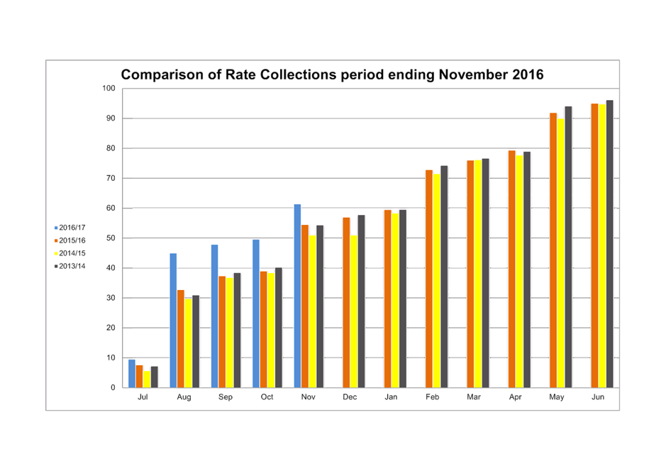
|
Item 2 Ordinary Meeting 20 December 2016
|
Item 2 - Annexure 1
|
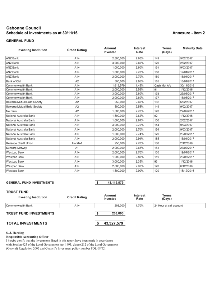
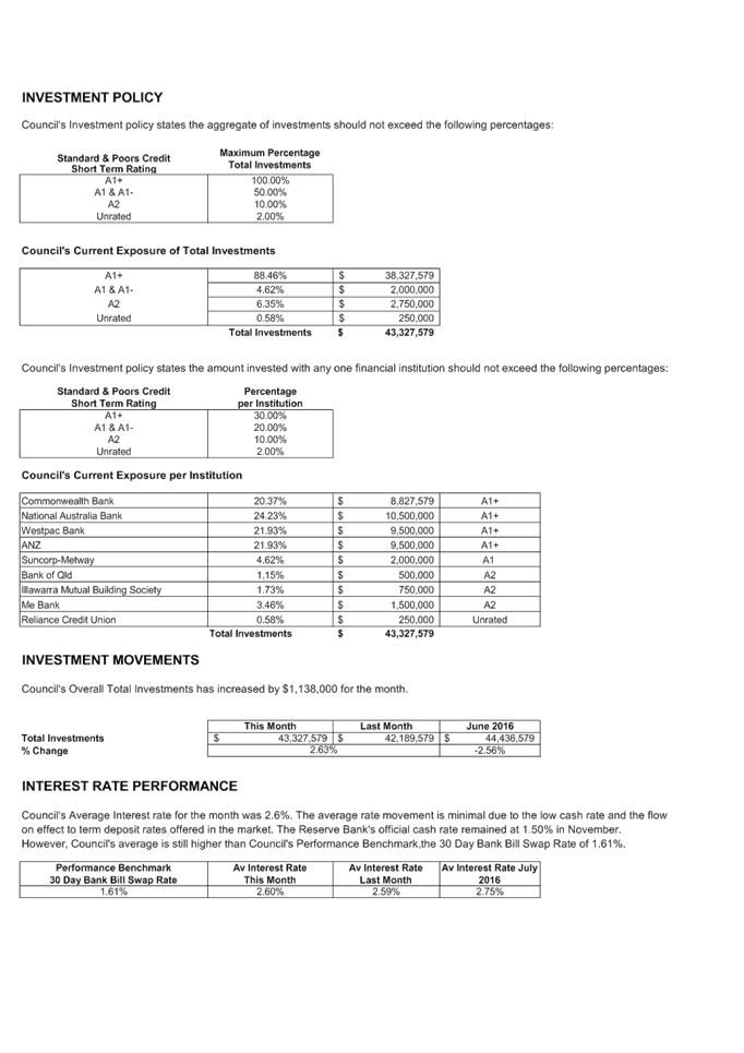
|
Item 4 Ordinary Meeting 20 December 2016
|
Item 4 - Annexure 1
|
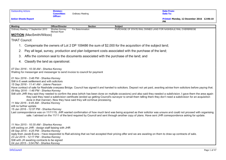
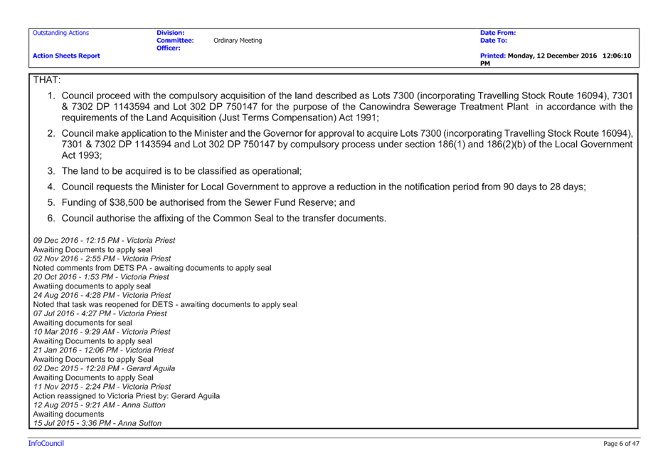
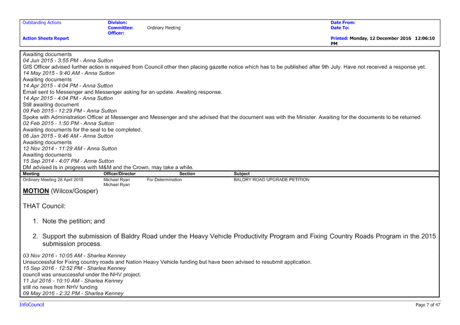
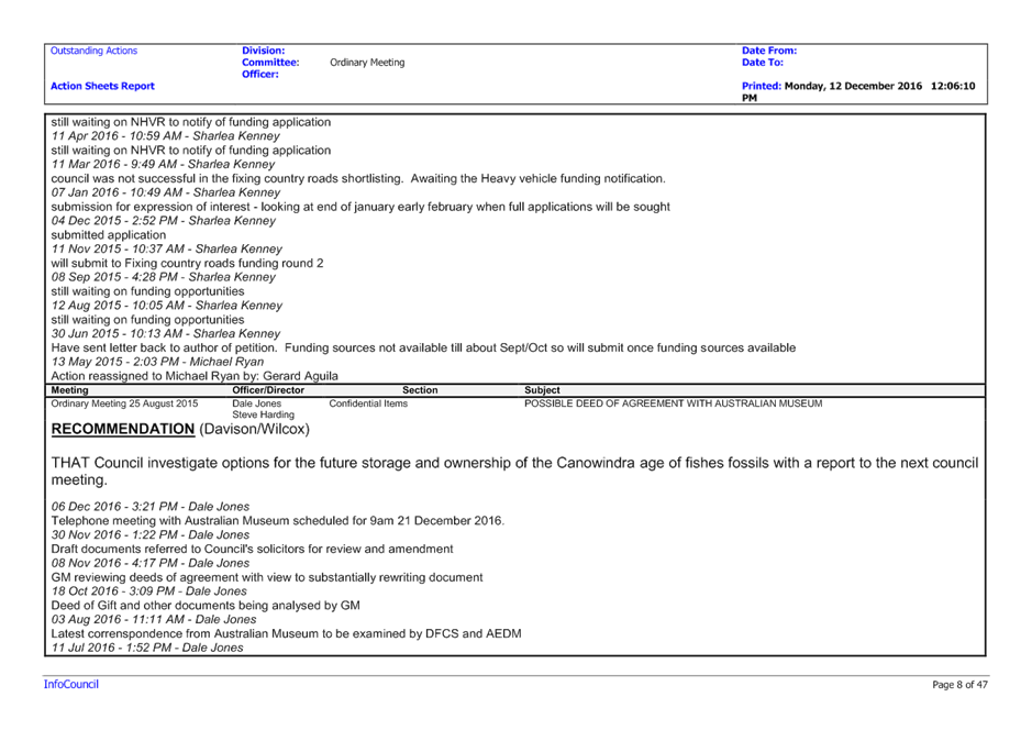
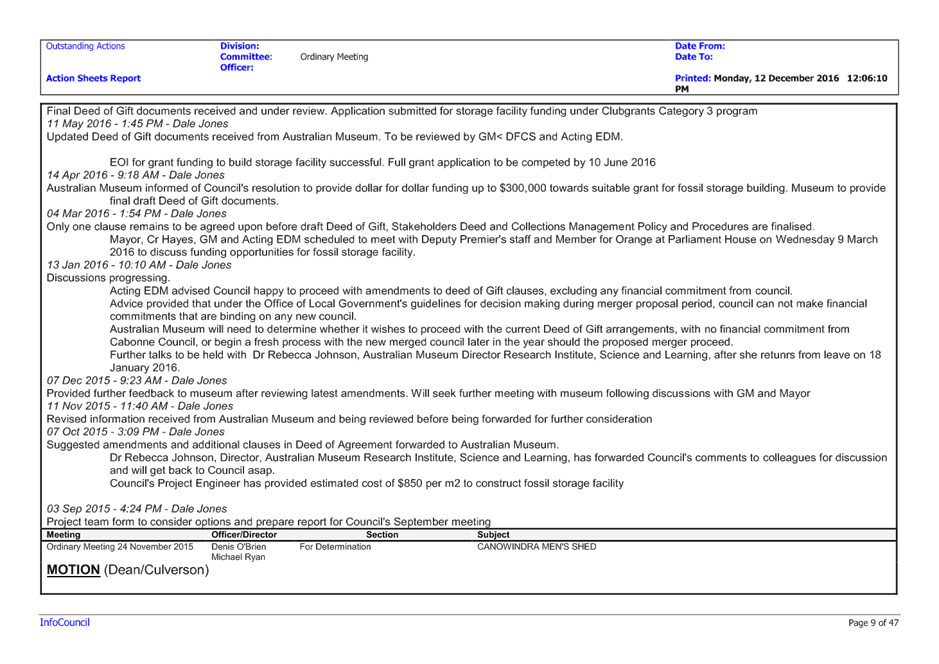
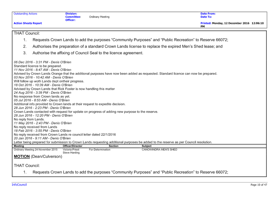
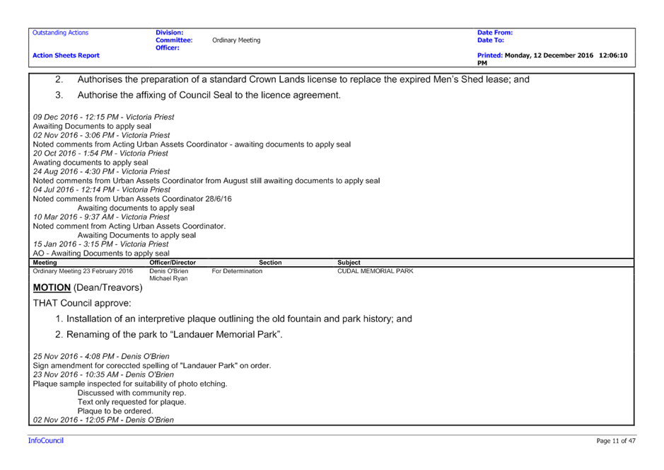
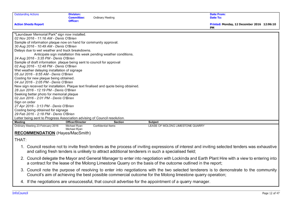
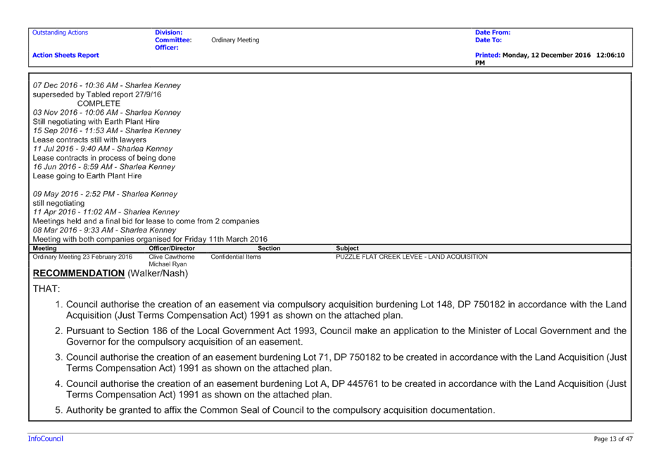
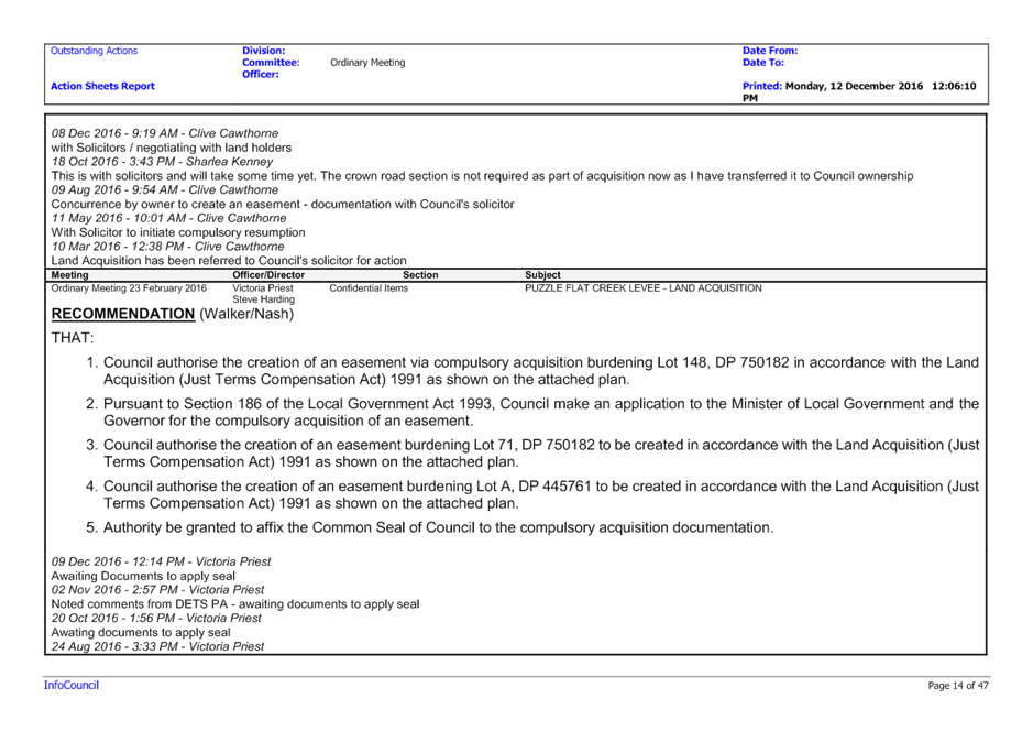
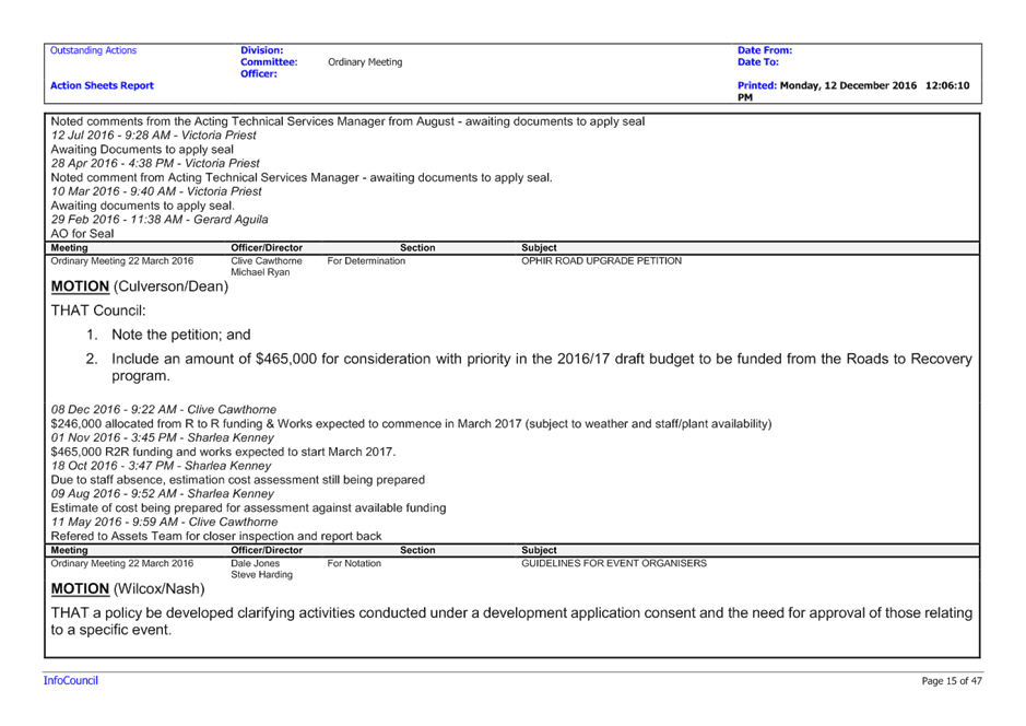
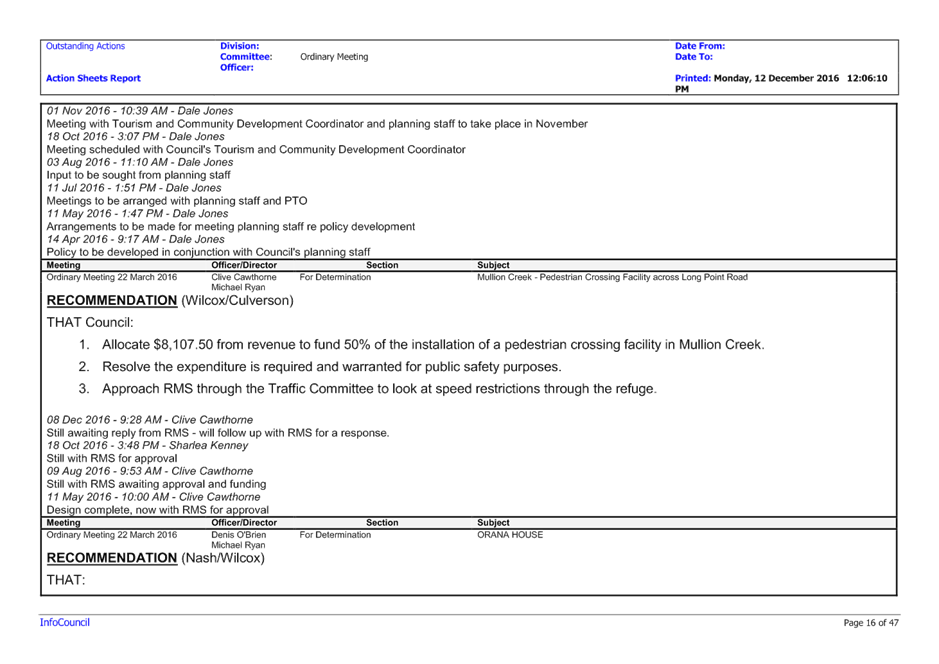
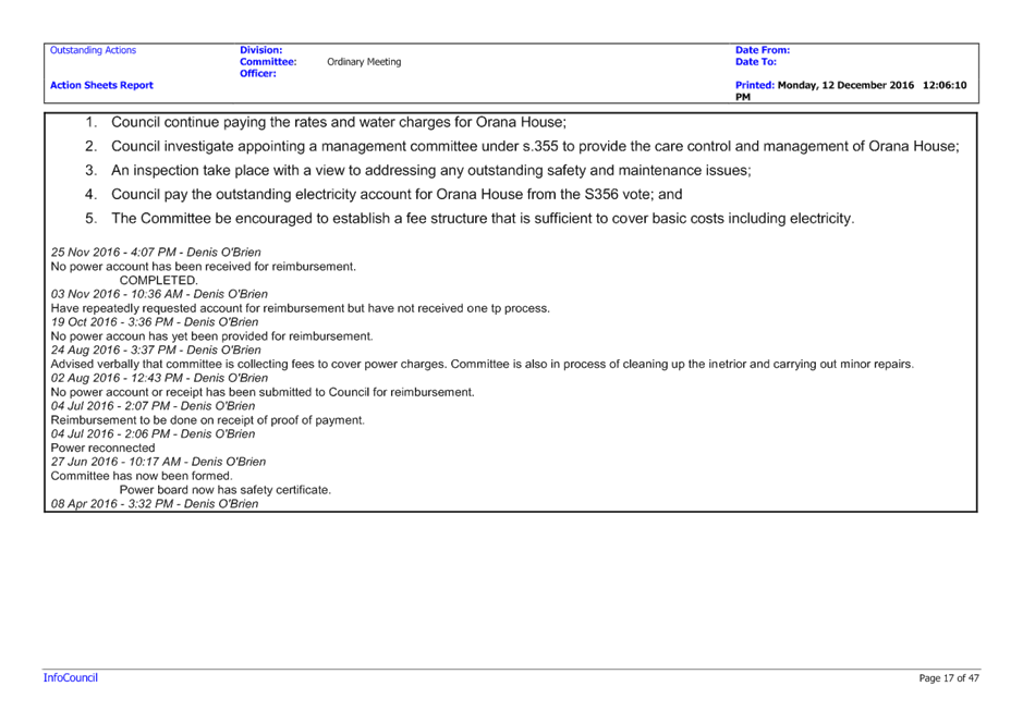
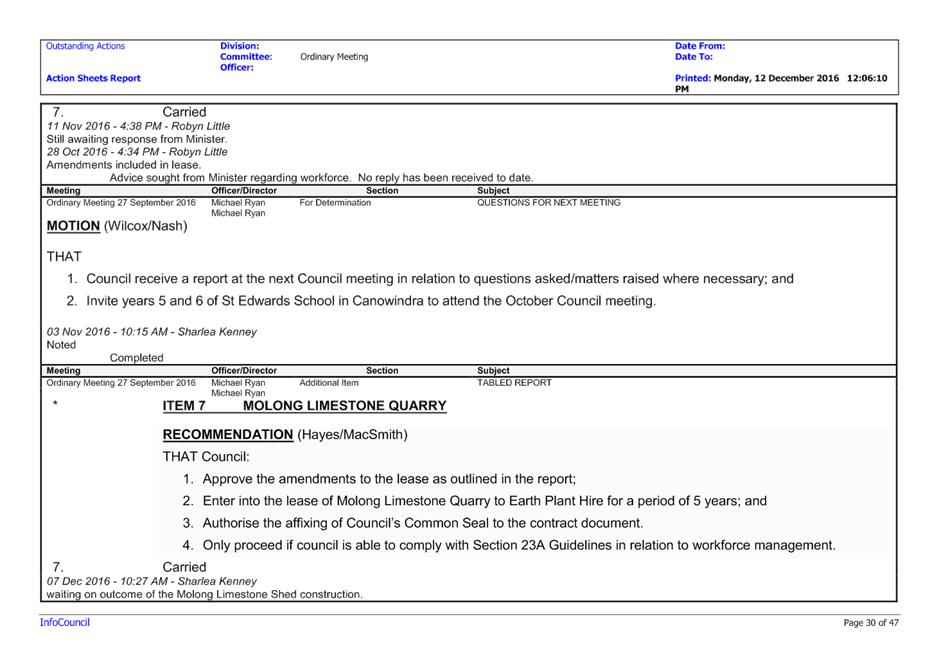
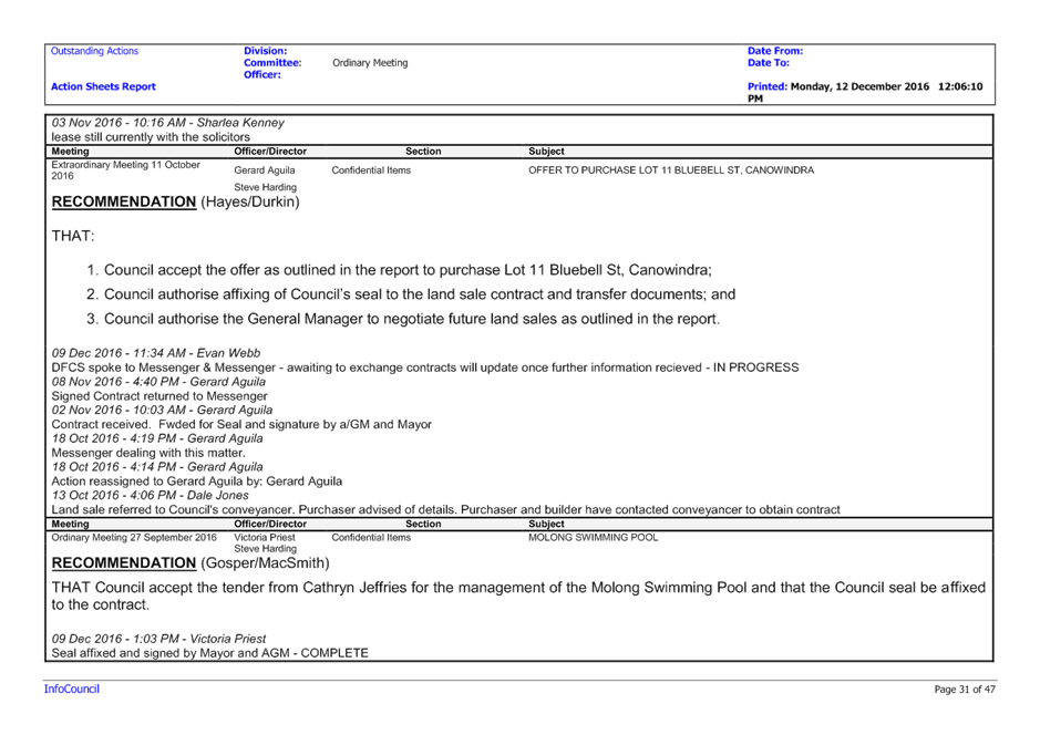
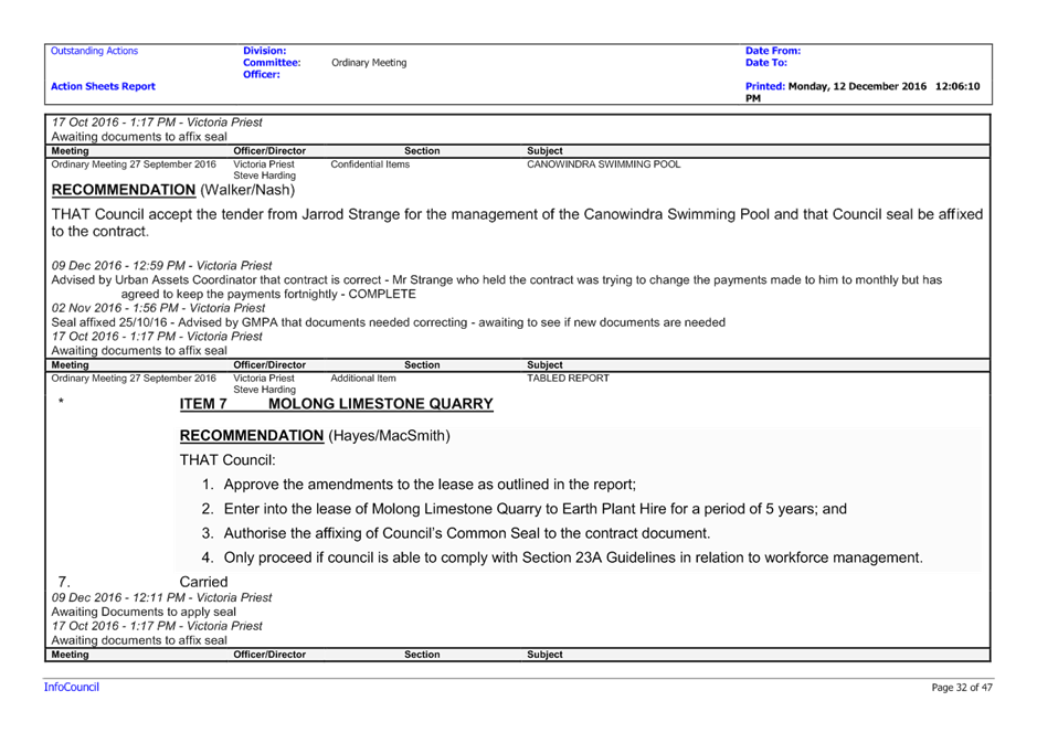
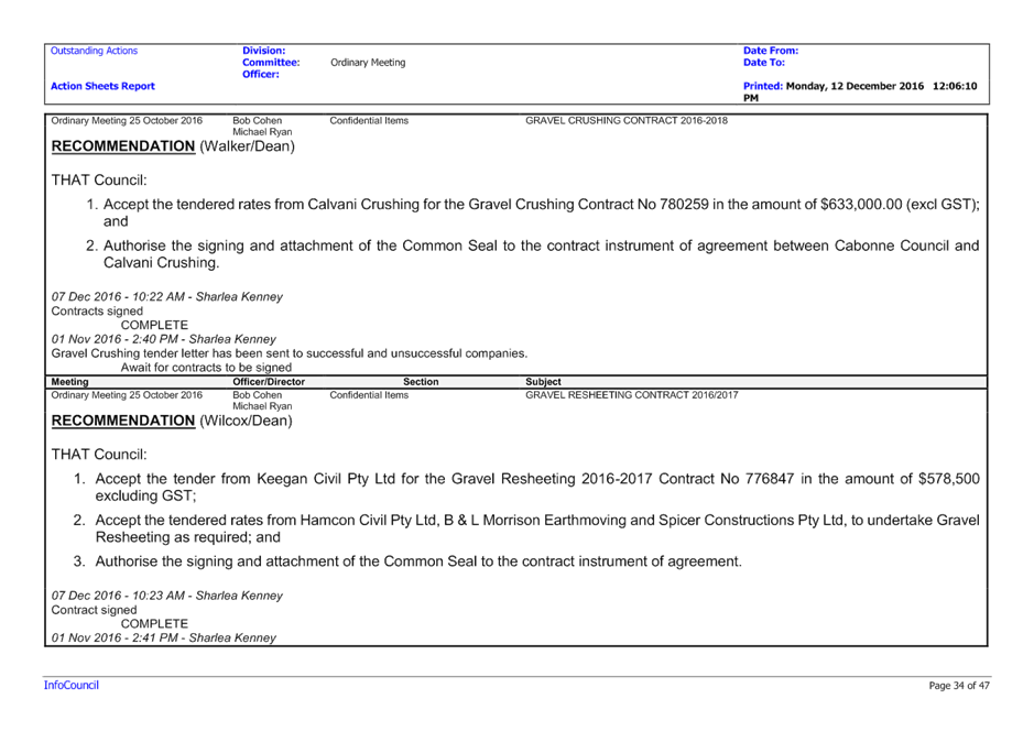
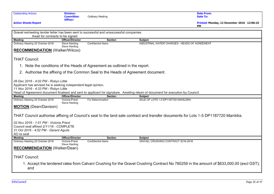
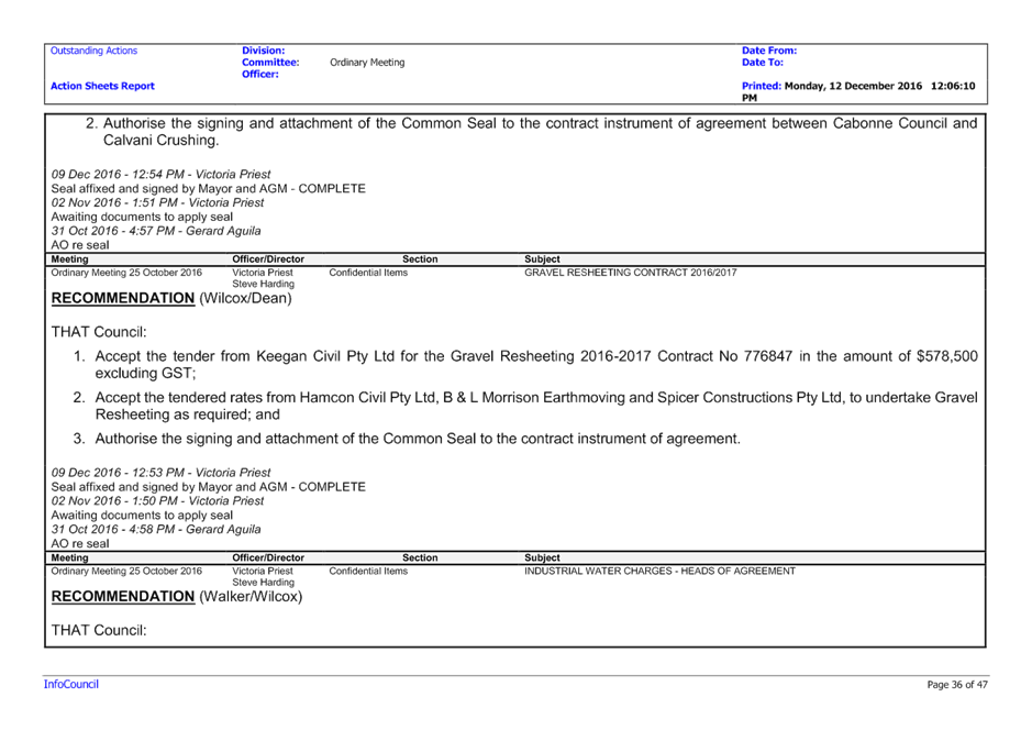
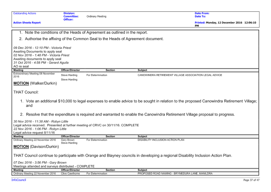
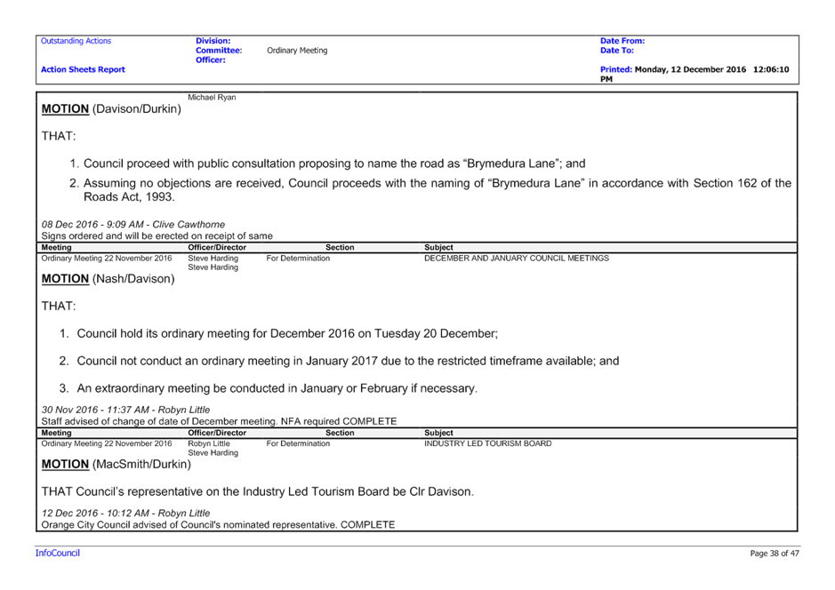
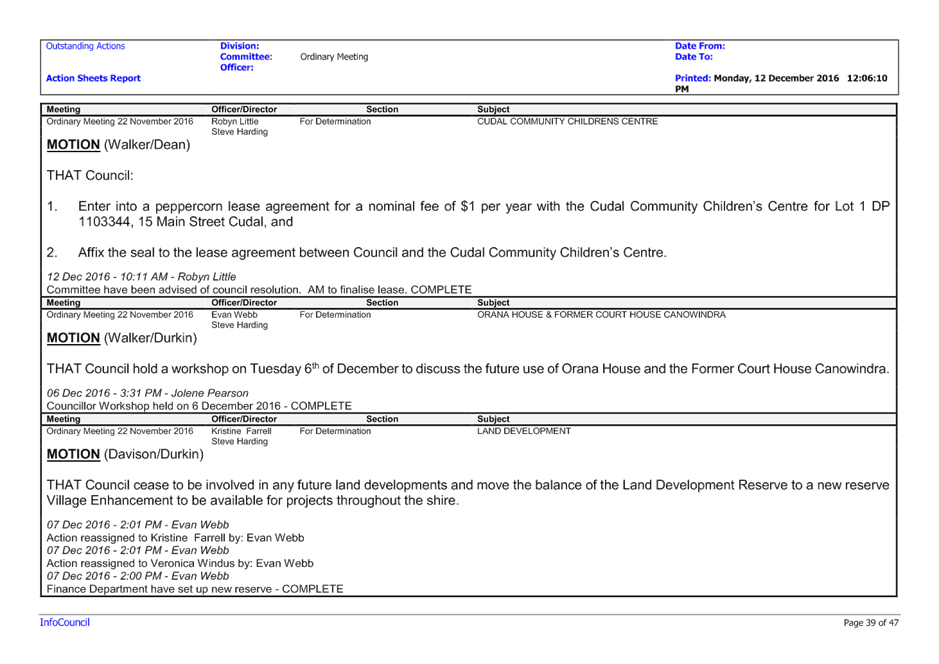
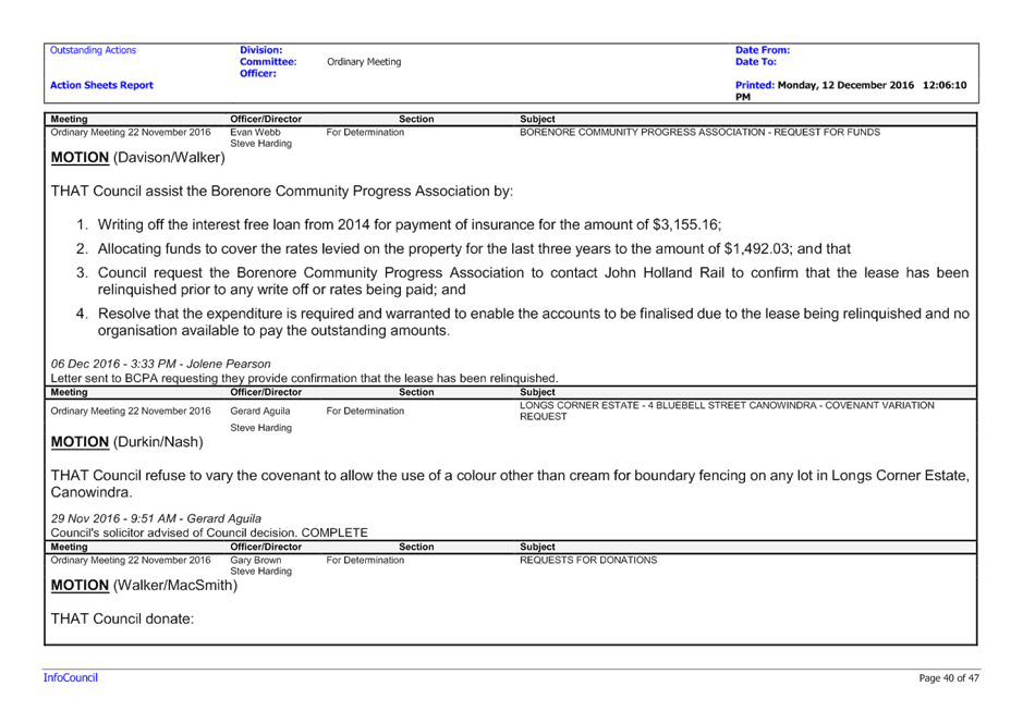
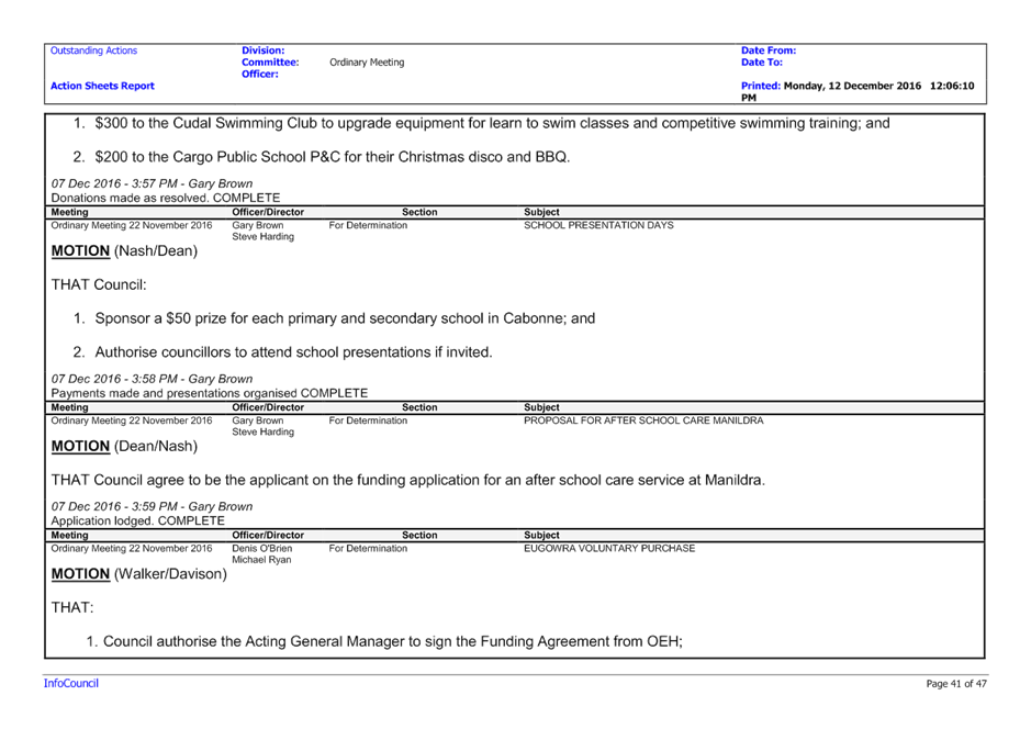
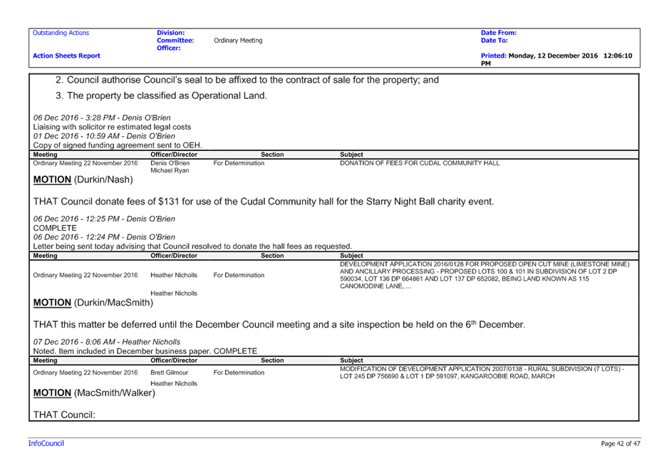
|
Item 4 Ordinary Meeting 20 December 2016
|
Item 4 - Annexure 2
|
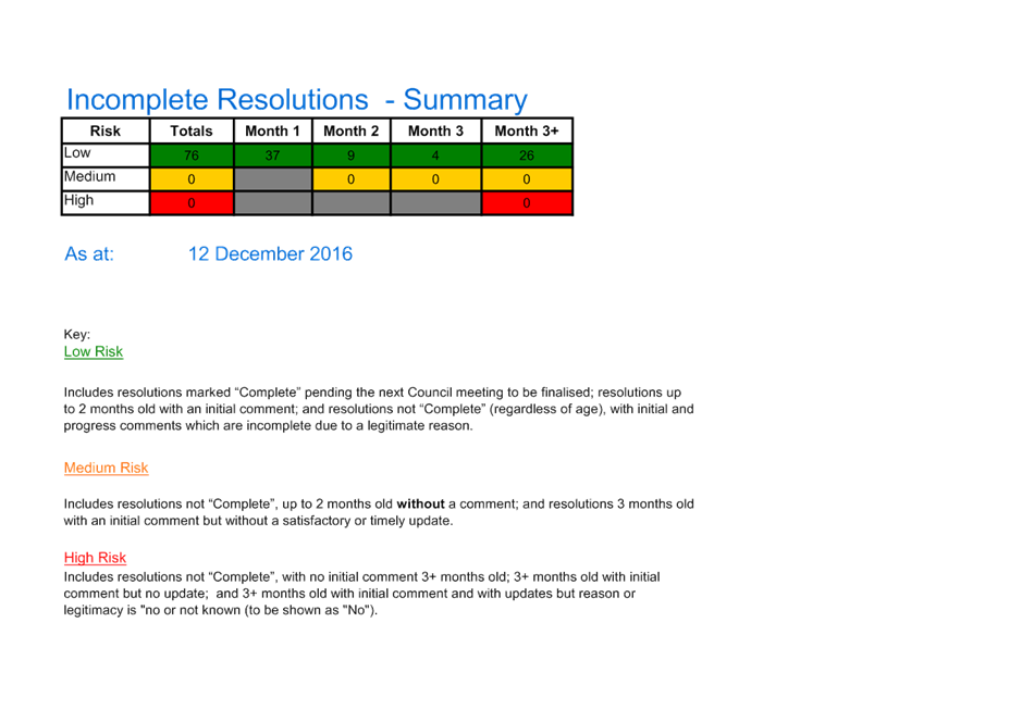
|
Item 5 Ordinary Meeting 20 December 2016
|
Item 5 - Annexure 1
|
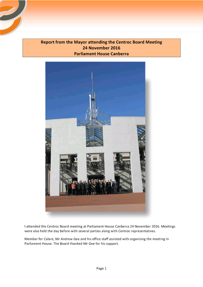
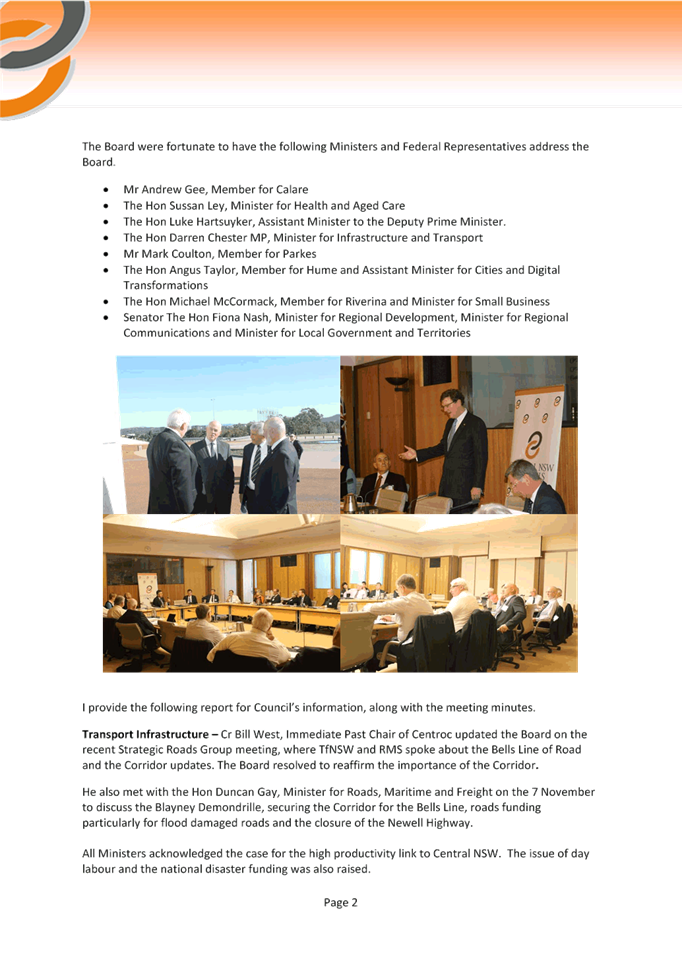
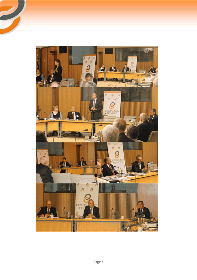
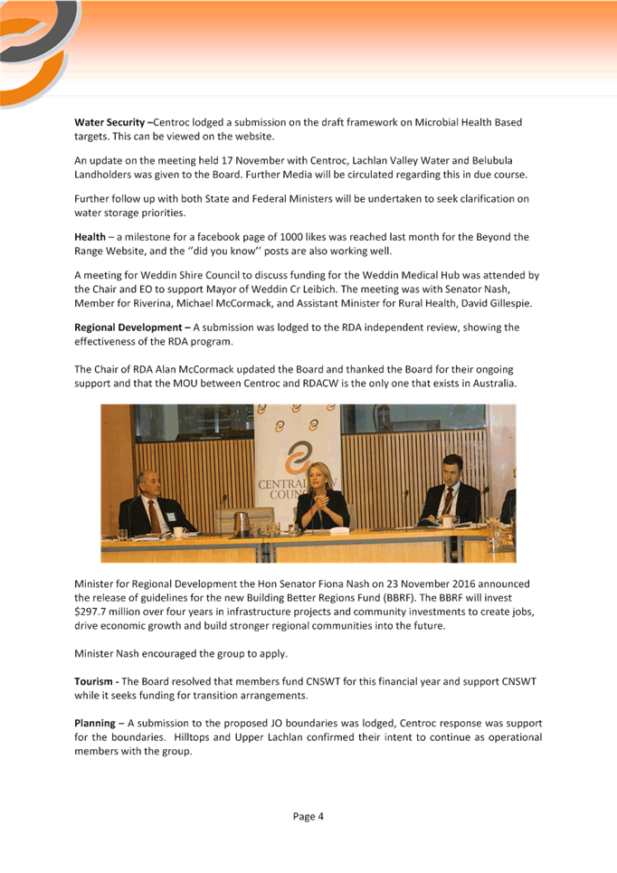


|
Item 5 Ordinary Meeting 20 December 2016
|
Item 5 - Annexure 2
|
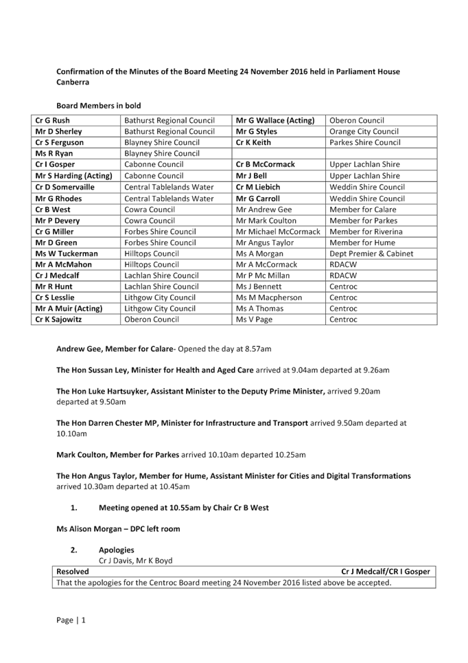
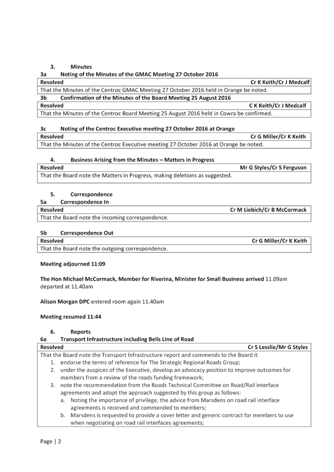
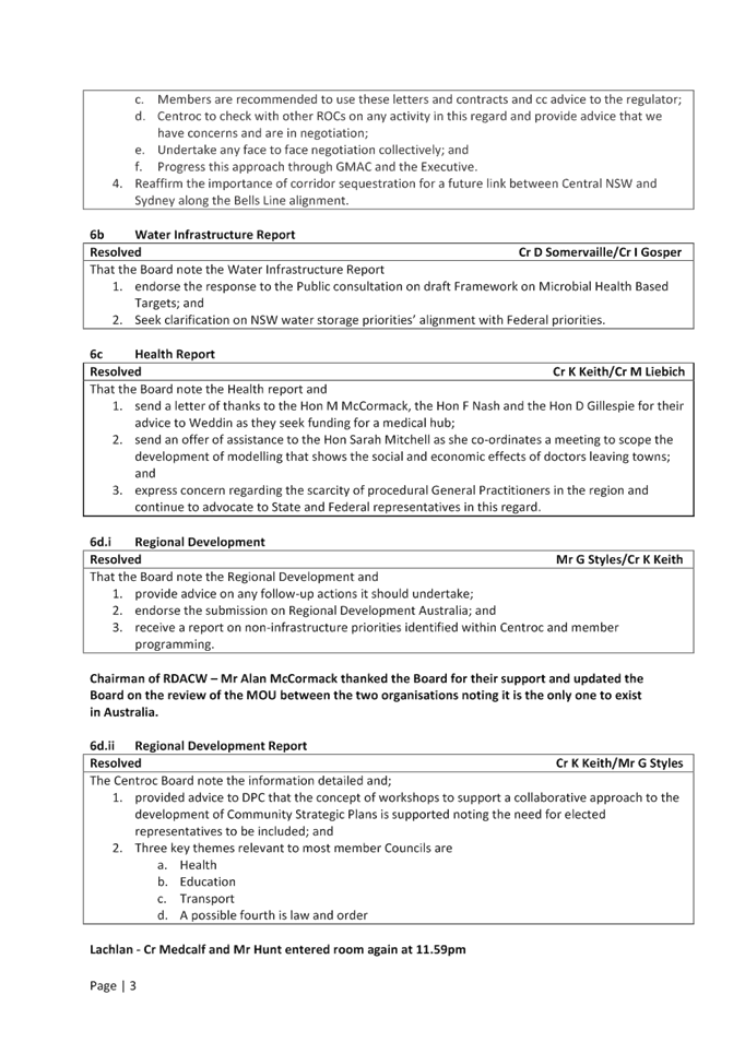
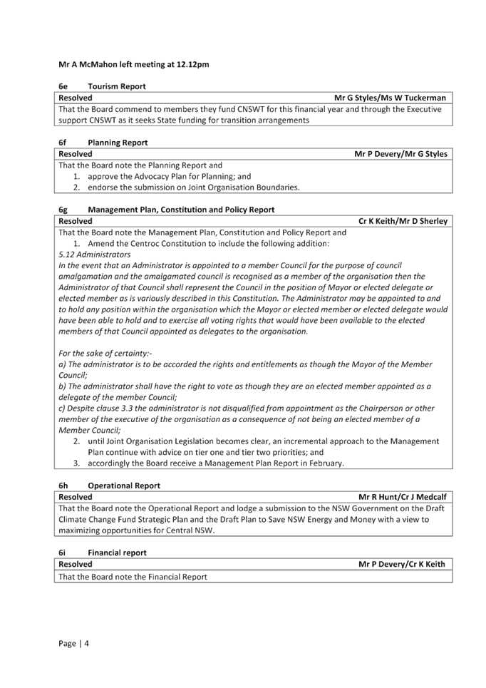
|
Item 5 Ordinary Meeting 20 December 2016
|
Item 5 - Annexure 3
|
|
Item 7 Ordinary Meeting 20 December 2016
|
Item 7 - Annexure 1
|

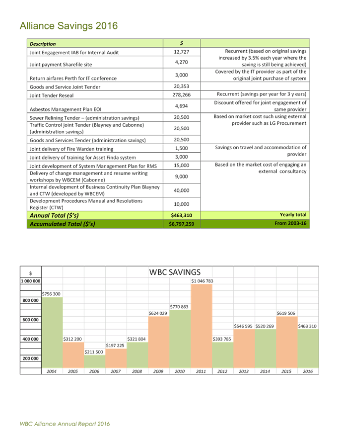
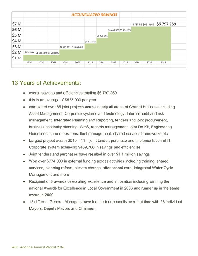
|
Item 10 Ordinary Meeting 20 December 2016
|
Item 10 - Annexure 1
|
MINUTES OF THE SMALL TOWNS DEVELOPMENT COMMITTEE
MEETING HELD AT THE MOLONG COUNCIL CHAMBERS ON TUESDAY 6 DECEMBER 2016
COMMENCING AT 7PM
Present: Don Bruce (Cumnock), Marion Gosper (Cudal), Kerry
Connelly (Molong), Dale Jones (Cabonne Council Acting Economic Development
Manager)
Apologies: Alf Cantrell (Yeoval), Glenda Gibson (Manildra), Lindy
Crossley (Mullion Creek
ITEM 1 CALL
FOR AN ACTING CHAIRPERSON
Motion:
That Don Bruce chairs the meeting.
Moved: K Connelly Second:
D. Jones Carried
ITEM 2 WELCOME
D Bruce
welcomed all to the meeting.
ITEM 3 APOLOGIES
Motion:
That the apologies be
accepted.
Moved: M Gosper Second:
K Connelly Carried
ITEM 4 MINUTES
M Gosper said her Cudal
report in the minutes of the meeting on 13 September 2016 mistakenly mentioned
David Grant as providing assistance with the production of Cudal News
when it should have been David Kidd.
Motion:
That this item of the
minutes of the meeting dated 13 September 2016 be corrected and that the
remainder are confirmed as being true and correct.
Moved: D Jones Second:
D Bruce Carried
ITEM 5 MATTERS
ARISING
Nil
ITEM
6 CORRESPONDENCE
Nil
ITEM 7 GENERAL
BUSINESS
The
committee congratulated Cabonne Council on the success of its recent Discover
The Riches tourism campaign promoting the villages of Cabonne and suggested
that should Cabonne Council continue as a stand-alone council in the future
that it consider running another Discover The Riches television advertising
campaign.
Delegates
said there appeared a larger number of visitors in the villages during the six
weeks of the campaign, with many coming from Orange and other central West
centres.
The
committee congratulated Marion Gosper, from Cudal, Glenda Gibson, from
Manildra, and Jenny Middleton, from Canowindra, on being included in the NSW
Government’s Hidden Treasures Honour Roll for 2016 which recognises the
efforts of women volunteers in rural communities.
It
was reported that Kerrie Christie was stepping down after 30 years as the
voluntary editor of Cumnock Progress Review newspaper. Val McKenzie will take
on the role.
After
14 years, Marion Gosper has retired from producing the Cudal News, with David
Kidd stepping into the position from next year.
The
committee congratulated and thanked Kerrie Christie and Marion Gosper for doing
an outstanding job in producing their local newspapers over many years and
wished their replacements all the best.
The
committee congratulated the Daroo Business Awards Committee and Cumnock
community for conducting a highly successful presentation dinner at Cumnock
Showground on 4 November 2016. All the feedback from various communities
throughout Cabonne indicated this was the best Daroos in the 17-year history of
the event.
7.1 EDM ACTIVITIES UPDATE
Projects and Programs
Cabonne Country Tourism Advisory Committee (CCTAC)
TP
Action 1.2.2
Next
CCTAC meeting is scheduled to be held on Tuesday 13 December 2016
What’s On In Cabonne Newsletter
TP
Action 2.1.1, 3.1.2
The
Cabonne ‘What’s On’ Newsletter promoted 21 events and
activities in November 2016. The main events included Jayes Gallery Classic
Music Night and Art Exhibition, various markets, Molong Salvation Toy Run and Amusu
Theatre film screenings.
The
newsletter is distributed via email to regional Visitors Centres, Cabonne
tourism operators, accommodation providers, schools, progress associations,
community groups and regional and local media. It is also posted on the Cabonne
Council and Cabonne Country websites and Facebook pages, with 350 hard copies
distributed throughout the shire.
Caravanning Industry Support
Cabonne
Council received a request from Yeoval Progress Association for the
installation of a dump point at the Yeoval Showground to cater for caravan
overnight stays. An application for a subsidy through the Campervan Motorhome
Club of Australia (CMCA) has been approved.
Cabonne Country Website
TP
Action 3.1.2, 3.4.2, 3.5.2
Statistics
collected from the Cabonne Country website indicate the following tourism
trends:
|
Month
|
Activity
|
2013
|
2014
|
2015
|
2016
|
|
January
|
Visits
|
Statistic
now not available
|
6,121
|
8,971
|
10,457
|
|
Hits
|
Statistic
now not available
|
83,274
|
123,475
|
|
|
|
|
February
|
Visits
|
Statistic
now not available
|
5,146
|
7,813
|
7846
|
|
Hits
|
59826
|
88,736
|
73,042
|
|
|
|
|
March
|
Visits
|
Statistic
now not available
|
6,269
|
7,937
|
6,259
|
|
Hits
|
95,799
|
80,202
|
113,645
|
|
|
|
|
April
|
Visits
|
Statistic
now not available
|
7,482
|
8,313
|
7,132
|
|
Hits
|
94,981
|
88,480
|
100,572
|
|
|
|
|
May
|
Visits
|
5,297
|
7,547
|
7,293
|
6,567
|
|
Hits
|
60,107
|
97,692
|
91,554
|
105,668
|
|
|
|
|
June
|
Visits
|
5,101
|
9,809
|
6,757
|
7,966
|
|
Hits
|
45,229
|
110,648
|
96,266
|
133,625
|
|
|
|
|
July
|
Visits
|
6,768
|
19,889
|
7,489
|
8,007
|
|
Hits
|
52,442
|
73,814
|
109,530
|
190,403
|
|
|
|
|
August
|
Visits
|
2,804
|
17,534
|
7,889
|
7,687
|
|
Hits
|
79,532
|
104,150
|
129,623
|
229,557
|
|
|
|
|
September
|
Visits
|
5,987
|
14,010
|
7,024
|
7,816
|
|
Hits
|
74,746
|
90,361
|
84,260
|
178,115
|
|
|
|
|
October
|
Visits
|
6,241
|
10,900
|
7,933
|
9,554
|
|
Hits
|
81,869
|
69,518
|
139,823
|
371,346
|
|
|
|
|
November
|
Visits
|
5,764
|
9,812
|
7887
|
|
|
Hits
|
70,612
|
103,591
|
124,306
|
|
|
|
|
|
December
|
Visits
|
5,950
|
10,015
|
7,211
|
|
|
Hits
|
69,626
|
96,778
|
109,865
|
|
|
|
|
|
|
Total
Visits
|
43,912
|
124,534
|
92,517
|
71,604
|
|
Total
Hits
|
534,163
|
997,158
|
1,137,183
|
1,514,542
|
Page
views jumped from 79,211 in May to 108,326 in June, 168,435 in July and 205,084
in August and with 155,457 page views in September with 315,741 page views in
October.
Advertising / Magazines
TP
Action 3.1.2
Editorial
and or advertisements were placed in the following printed media:
a. Discover Central NSW
Magazine
b. IMAG on the webpage
c. The Wanderer Magazine
d. Daroo Business Awards
Central NSW Tourism
TP
Action 5.2.2
Central
NSW Tourism Executive Officer Lisa Ditchfield is keeping Tourism Managers
across the central west informed regularly of ongoing developments, tourism
issues and promotional opportunities/initiatives.
Community Group Development
EDS Objective 9.4
The ED&T Team has administered the following
enquires and/or met with:
· Age of Fishes Museum – ongoing support.
· Cycling NSW - NSW Masters Championships Road race
April
· Bicycle Network – March 2017
· Central NSW Tourism
· Brand Orange
· Campervan & Motorhome Club of Australia –RV
Friendly Towns
· Canowindra Arts Group
· Cudal Show Ground ongoing support
· Pinnacle Dragon Boats Association
· Canowindra RSL Sub- Branch
Business Inquiries & Development
EDS
Objective 10.7, 9.2
Council
has administered the following enquires and/or met with:
a. Brand Orange
b. CENTROC
c. Orange City Council
d. Blayney Council
e. Adloyalty
f. Orange Wine Region
g. BEC Orange
h. Business Chamber -
Canowindra
i. Caravanning &
Motorhome Association
j. Age of Fishes
Museum
k. Yeoval Progress
Association
l. Central NSW
Tourism
m. Leukaemia Foundation
n. Orange Tri-Athlete
Association
Discover the Riches Villages Marketing Campaign
Council
received a request from Orange City Council to play the Discover the Riches
Villages marketing campaign video in the new Regional Visitor Information Centre
(VIC). The aim is to play the video to visitors to the area to continue the
promotion and awareness of our various villages.
Daroo Business Awards
Daroo
Business Awards Gala Dinner was held on Friday 4 November 2016. The well
attended successful event was capably coordinated by Cumnock Progress
Association.
The
guest speaker, NSW Small Business Commissioner, Robyn Hobbs OAM delivered an
informative account of her role, responsibilities and how the organisation
supports NSW small businesses.
The Employee of the Year
category was awarded to Cabonne Council’s Audrey Meehan and The
Apprentice/Trainee of the Year was Danielle Dugmore, from Molong Early Learning
Centre.
7.3
ROUND THE TABLE
CUDAL – Marion Gosper
· Cudal Tennis Club is very strong –
had a very successful kids coaching clinic
· Cudal Swimming Club is also ready for the
new season
· Milo Cricket for the young ones is also
very popular
· Cudal held a very successful Debutante Ball
in November. Seven debs and their partners were presented to Cabonne Mayor Ian
Gosper. They raised money for the Cancer Council and the total stands just over
$2500
· The Cudal Children’s Centre raised a
whopping $17,744 at their recent fundraiser Cudal Carnival. All of the funds
will go towards the renovation and expansion of the Centre, enabling them to
meet the growing demand for high quality education and care in the Cudal
district
· The Cudal Community Christmas Carols will
be held on the park land next door to Corden’s Store on Sunday 18
December at 7.30pm
· The Cabonne Food Wine and Cultural Centre
have had another profitable and efficacious year. They applied for a grant to
restore the Memorial Gates, but were not successful so the CFW&CC are going
to fund the restoration work. Additional names will be added and errors
corrected. Marble for the work is coming from Italy and the cost of the project
should be $6800. It is hoped the project will be finished for Anzac Day 2017.
· The park where the gates are situated has
recently been named “Landauer Park” after the family who donated
the ground for the park. We hope the council will soon correct the misspelling
of Landauer.
· Marion Gosper has retired from producing
the Cudal News after 14 years. David Kidd will doing the news next year.
Molong – Kerry Connelly
· Christmas Tree Celebrations last
Sunday went well, good numbers
· Salvation Army and Local Bike Group
carried out the Toy Run last Saturday week and made approximately $1100 from
raffles and barbecue. This will go towards hampers for Molong, Manildra,
Cumnock & Yeoval – 35 children and teenagers within our small villages
will be the deserved recipients of the toys and gifts donated on the day
· The Salvos are also doing pamper
packs for ladies for a number of ladies in the villages
· Christmas Carols on the Green Friday
9th December. Sausage sizzle to start off at 6.30pm
· Molong Express running a competition
for the best decorated mailbox, shop window and home display
· A Community Assistance Program grant
of $5000 from Cabonne Council will go towards a light show on the Christmas
Tree at the railway end of Bank St.
· 2 Fat Ladies opened at 21-23 Bank
Street. Grand opening with Champagne and nibbles next Wednesday 14 December
· Lolly Shop moving to number 12 Bank
Street
· Bowling Club new kitchen –
Chinese meals – going very well
· The Central School held a
Multicultural Festival and Food Festival in the past week. 19 child immigrants
(refugees) from the Liverpool area spoke about their experiences and
circumstances to help with awareness and the performed a drum concert.
· Mark Oates is painting a mural inside
the swimming pool cement wall – needs donations for resources etc
· Molong will hold their 2nd
Christmas Community Lunch at the Recreation Ground this Christmas day – 6
people have applied to date.
· Molong Tennis Club appears
as if it may fold. It is still deciding whether to try to have another annual
meeting.
· The Market Day in October
was very successful, with a record number of stalls.
Cumnock – Don Bruce
· Cumnock hosted another successful visit from the Zoo-To-Zoo
cyclists, catering for 130 riders. There will be two rides next year, the first
in February.
· The Cumnock Christmas Tree event will be held this
Saturday (10 December 2016) at the showground.
· Cumnock night tennis goes from strength to strength.
· The number of children participating in Little
Athletics is amazing, with families coming from outside Cumnock to be part of
the club.
· Cumnock Swimming Club is also attracting good numbers.
· There has been a change of editors at the Cumnock
Progress Review newspaper, with Val McKenzie replacing Kerrie Christie who has
been in the role for 30 years and has done an outstanding job. Kerrie will
continue to be involved in many organisations and activities in the village.
· The Cumnock Progress Review’s new printer
published its first issue last week.
· Cumnock RFS has taken delivery of a new Cat 6
multi-purpose tanker with a boom out the front. There was a large turnout for a
training day on Saturday morning (3 December 2016) and the tanker attended its first
fire the following day. The small fire was brought under control quickly.
ITEM
8 NEXT MEETING
The
next Small Town Development Committee meeting is to be held on Tuesday 14
February 2017 at 7pm at the Council Chambers in Molong.
ITEM 9 MEETING CLOSED
There
being no further business the meeting closed at 8.10pm
|
Item 12 Ordinary Meeting 20 December 2016
|
Item 12 - Annexure 1
|
|
ENGINEERING
and Technical Services Projects
DECEMBER
2016-2017
|
|
Budget
|
Actual
|
|
14 - Administration
|
$5,178,055
|
|
|
Connelly's Store Upgrade
|
$76,475
|
$26,334
|
|
Training Room Fit Out
|
$69,000
|
$0
|
|
Molong Depot Workshop
Replace Diesel and Petrol Underground Fuel Tanks
|
$115,000
|
$0
|
|
Molong Workshop Tyre
Changers & Tyre Balancer
|
$35,133
|
$28,773
|
|
Cudal Workshop
– Replace Roller Doors
|
$36,225
|
$16,095
|
|
Cudal Depot
/Workshop Upgrade Perimeter Security Fencing at Rear of depot/workshop
|
$30,119
|
$0
|
|
Refurbishment of
Canowindra HACC Office and Library
|
$230,000
|
$0
|
|
Cordons Store Cudal
Refurbishment
|
$30,475
|
$0
|
|
Cudal Office Roof
Sheeting, Gutters & Facia
|
$41,500
|
$28,064
|
|
Connelly's Store Molong
External Painting, Building Surrounds
|
$13,000
|
$0
|
|
Cudal Depot
Security Fence and Gate
|
$80,000
|
$0
|
|
16 - Public Order &
Safety
|
$252,000
|
|
|
Lidster Fire Station
|
$240,000
|
$0
|
|
Demolition of Cudal RFS
Shed
|
$12,000
|
$0
|
|
19 - Environment
|
$1,914,494
|
|
|
Canowindra Stormwater
Drainage Stage 1
|
$200,000
|
$0
|
|
Eugowra Flood Plain Levee
Completion of Study
|
$23,000
|
$0
|
|
Puzzle Flat Creek Levee
|
$1,150,000
|
$0
|
|
24 - Cabonne Water
|
$17,233,396
|
|
|
Molong High Level
Reservoir
|
$34,845
|
$0
|
|
Reinstatement of Water
Main Infrastructure
|
$47,530
|
$0
|
|
Electronic Meter Roll Out
|
$244,088
|
$2,125
|
|
Molong Water Mains: Kite
Street Water Main
|
$73,175
|
$0
|
|
Cabonne Telemetry Network
|
$11,288
|
$2,438
|
|
Monitoring Flow from the
Molong Creek Dam
|
$60,260
|
$0
|
|
Telemetry Unit
Installations
|
$141,680
|
$0
|
|
Molong Water Mains :
Mitchell Highway Water Main Renewal
|
$33,005
|
$0
|
|
Molong Water Mains :
Wellington St : Water Main Renewal
|
$33,005
|
$0
|
|
Molong Cumnock and
Yeoval Water Reticulation
|
$27,508
|
$0
|
|
Molong Cumnock and
Yeoval Installation of Gateways and Receivers for New Meter Conn
|
$54,280
|
$0
|
|
Molong Cumnock and
Yeoval Base Infrastructure for Integration of Smart
Meters
|
$78,545
|
$0
|
|
Pipeline Project
|
$14,562,500
|
$277,274
|
|
Molong Water Treatment
Plant Filter Review
|
$29,095
|
$0
|
|
Telemetry Base
Infrastructure
|
$73,140
|
$3099
|
|
Water Reservoir
Maintenance
|
$20,010
|
$0
|
|
Weirs Maintenance In
Accordance with AMP & DWMP Project
|
$12,880
|
$0
|
|
Annual Audits of Pump
Stations
|
$13,225
|
$0
|
|
|
|
|
|
26 - Small Town Sewer
|
$74,750
|
|
|
Cudal STP Inlet Structure
|
$40,250
|
$0
|
|
STSS Assets Manildra
STP Inlet Structure
|
$34,500
|
$0
|
|
27 -Cabonne Sewer
|
$698,994
|
|
|
All Weather Bypass and
Thistle St Pump Station Electrical Upgrade
|
$120,060
|
$0
|
|
Canowindra Sewer Reuse
Reticulation Rectification
|
$92,000
|
$640
|
|
Canowindra Sewer
Sludge Disposal Treatment Rectification
|
$100,000
|
$11,224
|
|
Molong STP Sludge
Disposal Treatment Rectification
|
$140,000
|
$0
|
|
Canowindra Pump Station 1
Anzac Road: To Replace Inlet Valve
|
$8,602
|
$1,667
|
|
Eugowra STP Inlet
Structure Construct New Inlet Structure
|
$34,626
|
$0
|
|
Linking of Molong
Reticulation Zones (Cnr of Molong & Phillip Streets)
|
$14,876
|
$690
|
|
Eugowra STP _ Earthworks
of Embankment Rehabilitation for Inlet Ponds
|
$28,750
|
$7,027
|
|
Mechanical Mixers Upgrade
of Aeration System at the Molong STP
|
$137,080
|
$98,500
|
|
Canowindra Eugowra &
Molong Sewer Mains Asset Revaluation
|
$23,000
|
$0
|
|
|
|
|
|
28 -Recreation &
Culture
|
$3,532,303
|
|
|
Cumnock Showground New
Amenities Building
|
$160,000
|
$0
|
|
Age of Fishes Museum
Fossil Storage Facility
|
$300,000
|
$9,764
|
|
Molong Library
Establishment /Refurbishment / Construction
|
$1,380,000
|
$60,190
|
|
Halls
|
$511,865
|
|
|
Mitchell Room Molong
Structural and Architectural Report
|
$230,000
|
$0
|
|
Cudal Hall Refurbishment
|
$176,065
|
$0
|
|
Other
|
$105,800
|
$69,764
|
|
Pools
|
$130,065
|
|
|
Canowindra Pool – 3 shade covers
|
$52,900
|
$0
|
|
Other
|
$129,317
|
$59,511
|
|
Sporting Grounds
|
$835,725
|
|
|
Molong Multipurpose Sports
Venue
|
$793,500
|
$61,471
|
|
Parks and Gardens
|
$41,653
|
$22,096
|
|
Playgrounds
|
$13,225
|
$0
|
|
37 -Economic Affairs
|
$274,583
|
|
|
Cabonne Village Local Area
Planning Molong & Canowindra Central Areas
|
$162,525
|
|
|
Caravan Parks – including
BBQ Shelters, Toilet Upgrade, Gutters
|
$31,558
|
$866
|
|
32 - Quarry
|
$180,000
|
|
|
Quarry Assets Molong
Quarry Limestone Storage Shed
|
$180,000
|
$25,992
|
|
34 - Transport &
Communication
|
|
|
|
Local Road
Construction Blackspot
|
$726,300
|
|
|
Local Roads Blackspot
16/17 Pinnacle Road Mt Canobolas to OCC Boundary
|
$726,300
|
$0
|
|
Local Road Construction
Funded by Road to Recovery
|
$3,089,028
|
|
|
Davys Plains Road and Nanima
Lane (continued from 2015-2016)
|
$177,464
|
$117,362
|
|
Packham Drive Stage 3
|
$410,000
|
$438,023
|
|
Packham Drive Stage 4
|
$410,000
|
$73,624
|
|
Yellowbox Road Road
Widening Reconstruct Longitudinal Drainage & Seal
|
$516,818
|
$0
|
|
Bocobra Road Shape
& Seal & Repair to Longitudinal Drainage
|
$100,000
|
$0
|
|
Yellowbox Road
Intersection Improvement Coates Creek Road
|
$175,000
|
$0
|
|
Convent Road Pavement
& Shoulder Strengthening & Widening
|
$200,210
|
$0
|
|
Bobcobra Road Gravel
Resheet and Repair Surface Drainage
|
$182,000
|
$0
|
|
Sherwin Road Cargo
Improvement Pavement
|
$75,000
|
$24,884
|
|
Baghdad Road Cargo
Improvement Pavement Shape & Seal
|
$100,000
|
$73,381
|
|
Ophir Road Road Widening
Reconstruct Longitudinal Drainage & Seal
|
$465,000
|
$32,810
|
|
Long Point Road
Wardells Hill Shape Seal & Repair Longitudinal Drainage
|
$200,000
|
$22,231
|
|
Long Point Road Drainage
Improvements on Causeways
|
$80,000
|
$0
|
|
Davies Plains Road
Intersection Improvements Gavins Lane
|
$175,000
|
$0
|
|
Local Road
Construction Urban Reseal Program
|
$287,200
|
|
|
Belmore Street
|
$32,000
|
$0
|
|
Brown Avenue
|
$20,000
|
$0
|
|
Derowie Street
|
$15,000
|
$0
|
|
Edward Street
|
$24,500
|
$0
|
|
Forbes Street
|
$48,000
|
$0
|
|
Phillip Street
|
$29,000
|
$0
|
|
Toogong Street
|
$14,500
|
$0
|
|
Smith Street
|
$49,000
|
$0
|
|
Ryall and Mill St
Canowindra
|
$55,200
|
$0
|
|
Local Road Construction
Rural Reseal Program
|
$914,500
|
$58,536
|
|
James Dalton Drive (carried over
from 2015/16)
|
|
$16,205
|
|
Madelines Lane (carried over
from 2015/16)
|
|
$18,554
|
|
Mt Canobolas 2.3km final gravel section
|
$130,000
|
$34,703
|
|
|
|
|
|
Local Road Construction
Heavy Patching
|
$897,500
|
|
|
Long Point Road
|
$75,000
|
$0
|
|
Iceley Road
|
$120,000
|
$0
|
|
Ophir Road
|
$90,000
|
$0
|
|
Packham Drive
|
$40,000
|
$0
|
|
Kurrajong Road
|
$100,000
|
$0
|
|
Four Mile Creek Road
|
$80,000
|
$0
|
|
Baldry Road
|
$80,000
|
$0
|
|
Bradleys Road
|
$40,000
|
$0
|
|
Amaroo Road
|
$100,000
|
$0
|
|
Cullya Road
|
$65,000
|
$105,876
|
|
Unidentified as at March
2016
|
$50,000
|
$0
|
|
Davys Plains Road
|
$57,500
|
$0
|
|
Local Road Construction
Gravel Resheeting
|
$739,000
|
|
|
Lower Lewis Ponds Road
|
|
$46,309
|
|
Bocobra Road
|
|
$23,115
|
|
Gregra- Taylors Road
|
|
$11,476
|
|
|
|
|
|
Local Road Construction
Funded by Fixing County Roads & RMS & Council
|
$517,500
|
|
|
Gumble Road Sealing (continued
from 2015-2016 where $1,390,902 was spent)
|
|
$605,748
|
|
Truck Turning Bay Manildra
|
$517,500
|
$0
|
|
Local Road Construction
Funded by Budget
|
$166,750
|
|
|
Local Roads 16/17
Canowindra Laneways
|
$115,000
|
$9,063
|
|
Gasworks Lane Full renewal
|
$51,750
|
$0
|
|
Local Road
Construction Additional Infrastructure Allocation for 16/17
|
$3,450,000
|
|
|
Archer Road Bitumen Seal
|
$ 100,000
|
$0
|
|
Back Mogong Road Gravel
Resheeting
|
$ 52,000
|
$0
|
|
Back Nyrang Road Gravel Resheeting
|
$ 52,000
|
$0
|
|
Boree Lane Pavement
rehabilitation
|
$ 100,000
|
$0
|
|
Windus Road Pavement
rehabilitation
|
$ 85,000
|
$0
|
|
Canobolas Road Shoulder Widening
|
$ 100,000
|
$0
|
|
Cullya Road Heavy Patching
|
$ 120,000
|
$0
|
|
Eulimore Road Bitumen Seal
|
$ 85,000
|
$0
|
|
Favell Road Bitumen Seal
|
$ 50,000
|
$0
|
|
Fish Fossil Drive Bitumen Seal
|
$ 170,000
|
$5750
|
|
Gidley Street Molong Upgrade of
drainage infrastructure
|
$ 200,000
|
$5,750
|
|
Greenings Lane Pavement Resheet
and Drainage Work
|
$ 100,000
|
$0
|
|
Hicks Street Cargo Pavement
Rehabilitation
|
$ 40,000
|
$5,599
|
|
Hoffmans Road Gravel Resheeting
|
$ 26,000
|
$0
|
|
James Dalton Drive Heavy Patch
|
$ 90,000
|
$94,091
|
|
James Dalton Drive Reseal
|
$ 33,000
|
$34,500
|
|
Kent Road Bitumen Seal
|
$ 100,000
|
$41481
|
|
Larras Lee Road Gravel
Resheeting
|
$ 26,000
|
$0
|
|
Lookout Road Extension of Seal
|
$ 110,000
|
$0
|
|
MacDonalds Road Bitumen Seal
|
$ 130,000
|
$0
|
|
Madelines Lane Heavy Patching
|
$ 62,000
|
$83,577
|
|
Main Street Cudal - Rear access
to depot
|
$ 50,000
|
$0
|
|
McKay Road Gravel Resheeting
|
$ 26,000
|
$0
|
|
Mill Street Canowindra
Stormwater drainage
|
$ 100,000
|
$0
|
|
Mousehole Lane Bitumen Seal
|
$ 100,000
|
$17,820
|
|
Mousehole Lane Drainage
Structure
|
$ 125,000
|
$43,317
|
|
Nanami Lane Gravel Resheeting
|
$ 52,000
|
$0
|
|
Nashdale Lane Bitumen Seal
|
$ 100,000
|
$9,404
|
|
Old Canobolas Road Bitumen Seal
|
$ 100,000
|
$4,277
|
|
Old Canobolas Road Gravel
Resheeting
|
$ 52,000
|
$54,290
|
|
Palings Yard Loop Bitumen
Sealing
|
$ 95,000
|
$0
|
|
Reedy Creek Road Gravel
Resheeting
|
$ 26,000
|
$0
|
|
Spring Glen Estate Bitumen Seal
|
$ 150,000
|
$161,402
|
|
Spring Hill Road Bitumen Seal
|
$ 100,000
|
$0
|
|
Stapletons Road Gravel
Resheeting
|
$ 26,000
|
$0
|
|
Toogong Cemetery Road
|
$ 85,000
|
$0
|
|
Toogong Village Streets Bitumen
Sealing
|
$ 33,000
|
$0
|
|
Union Street Cargo Bitumen
Sealing
|
$ 30,000
|
$21,947
|
|
Waterhole Creek Road Gravel
Resheeting
|
$ 26,000
|
$0
|
|
Wenz Lane Canowindra Pavement Rehabilitation
|
$ 110,000
|
$0
|
|
Whitelys Road Gravel Resheeting
|
$ 33,000
|
$0
|
|
Windus Road Pavement
Rehabilitation
|
$ 85,000
|
$465
|
|
Table drain maintenance
|
$ 200,000
|
$18,041
|
|
Dederang Street, Manildra
Rehabilitation
|
$ 70,000
|
$10,081
|
|
|
|
|
|
Regional Road
Construction Black Spot Funded
|
$573,500
|
|
|
Blackspot Program
16/17 Nangar/Warraderry Road Intersection
|
$44,500
|
$0
|
|
Blackspot Program 16/17
Cargo Road Shoulder Widening at Bowan Park Road Intersection
|
$529,000
|
$478,359
|
|
Regional Road
Construction RMS Safety Program
|
$900,000
|
|
|
Cargo Road Overtaking
Lanes Congestion and Safety Program
|
$900,000
|
$30,817
|
|
Regional Road
Construction RMS Repair Program
|
$800,000
|
|
|
Regional Road Repair 16/17
Nangar Road
|
$180,000
|
$0
|
|
Regional Road
Construction Heavy Patch & Reseal Program
|
$422,000
|
|
|
Regional Reseal - Renshaw
McGirr Way
|
$100,000
|
$0
|
|
Regional Reseal - Banjo
Patterson Way
|
$100,000
|
$0
|
|
Regional Heavy Patch -
Belubula Way
|
$57,000
|
$0
|
|
Regional Heavy Patch -
Cargo Road
|
$165,000
|
$78,588
|
|
Bridge Construction
Local Bridges
|
$1,581,250
|
|
|
Bridge 16/17 Bridge
Renewal Program Round 2( To Be Advised)
|
$1,581,250
|
$0
|
|
State Road Ordered Works
|
|
|
|
MR61 Install rumble strips
at Monument intersection
|
$54,250
|
$8,789
|
|
MR310 Heavy Patching
|
$202,772
|
$0
|
|
MR377 Escort Rock Shoulder
Widening and Safety Barriers
|
$444,875
|
$98,936
|
|
MR377 Culvert Near Cudal Airport
|
$18,115
|
$0
|
|
MR359 Reseal
|
$108,576
|
$72,354
|
|
MR310 Reseal
|
$568,511
|
$3,960
|
|
MR61 Final Seal at Manildra West
Stage 1
|
$111,569
|
$0
|
|
MR310 Heavy Patching in Reseal
Area
|
$330,407
|
$166,402
|
|
MR359 Heavy Patching in Reseal
Area
|
$119,171
|
|
|
MR359 Heavy Patching for Road
Detour during flood damage
|
$353,424
|
$26,590
|
|
MR310 Heavy Patching for Road
Detour during flood damage
|
$1,114,349
|
$343,360
|
|
MR61 Heavy Patching for Road
Detour during flood damage
|
$1,031,095
|
$85,482
|
|
MR377 Heavy Patching for Road
Detour during flood damage
|
$616,053
|
$23,526
|
|
MR377 Reedy Creek Shoulder
Widening and Rehabilitation
|
$1,218,639
|
$303,340
|
|
MR310 Reseal
|
$214,658
|
$620
|
|
MR359 Shoulder Widening
|
$67,786
|
$
|
|
|
|
|
|
Kerb & Guttering
Construction
|
$104,075
|
|
|
McLaughlin Street to Banjo
Paterson Way (cont’d from 2015-2016)
|
$42,000
|
$29,042
|
|
Cumnock School K&G,
layback & pram ramp
|
$51,175
|
$51,030
|
|
Kerb Ramps various
locations from AMP
|
$52,900
|
$0
|
|
Stormwater Drainage
Construction
|
$178,250
|
|
|
Culvert Works 16/17 From
AMP list to be split
|
$178,250
|
$0
|
|
Pathway Construction
|
$140,580
|
|
|
Pathway & Cycelway
16/17 Pedestrian Refuge Main & Cargo Sts Cudal
|
$55,000
|
$0
|
|
Pathway & Cycleway
16/17 Pedestrian Refuge Main & Smith Streets Cudal
|
$60,500
|
$0
|
|
Pathway & Cycleway
16/17 Pedestrian Refund and Ramps Grevillea Ave Eugowra
|
$12,540
|
$0
|
|
Transport &
Communication
|
$44,850
|
|
|
Canowindra / Church St
Public School Carpark
|
$29,900
|
$0
|
|
Street Light Edward Street
Molong
|
$14,950
|
$7,760
|
Natural Disaster
On the 26 August 2016 the Notice of Natural Disaster
was declared by the NSW Department of Justice. This was for the NSW
Inland Storms and Floods event of 20 July 2016.
On the 27 September 2016 the second Notice of Natural
Disaster was declared by the NSW Department of Justice. This was for the
NSW Inland storms and floods 30 August 2016.
As a generalisation over the Cabonne road network, the
damage has been variable. The most significant impact has been on the state
road network, resulting from the increase of heavy vehicles, due to the closure
of the Newell Highway and the necessity to re-route the traffic from Cowra to
Cudal, Cudal to Parkes and Cudal to Molong. The RMS have indicated that they
would fund the repair work sustained due to the increase of traffic. This work
has been completed 7th December 2016
On other sections of the network, Council staff are
gathering and recording data relating to road and asset damage due to the flood
events. This data will be collated and costed and a brief will be presented to
the RMS for assessment.
STATE ROADS
Heavy Patching
Heavy Patching works have been completed by Cabonne
Council’s contractor on the RMS State Road Network MR310 Canowindra Road,
MR359 Peabody Road, MR Escort way and MR61 Henry Parkes Way due the pavement
deterioration as a result of the detour of heavy vehicles on this road.
Canowindra Road from Canowindra to Cudal, and on Henry Parkes Way from the
Monument to Parkes Boundary.
MR377 Reedy Creek Shoulder Widening and Pavement
Rehabilitation
The Project site is located at
approximately 29.02 to 31.56 kilometres west of the MR61/MR377 intersection,
50km west of Orange. and involves widening the existing formation and
shoulders to provide a 9 m seal. Drainage structures have been completed,
and vegetation has been cleared to provide a clear zone through the area. These
works commenced in October and will be finished by the end of December. A
concrete kerb will be constructed through the rock cutting at a later date, as
there are issues regarding lose rock throughout the cutting.
MR377 Escort Rock Barrier Installation and Hazard
Removal
The Project involves barrier installation
with a one metre sealed shoulder and hazard removal to achieve a 7 metre clear
zone. The Project site is located at approximately 3.3 to 4.6 kilometres south
of the intersection between MR377 and Norris Lane, to the north-west of
Eugowra. Council’s contractors have undertaken vegetation works to
provide the clear zone. On completion of the Reedy Creek Shoulder
Widening and Pavement Rehabilitation, the works crew will undertake shoulder
works at The Escort Rock.
REGIONAL ROADS.
Hanover
Creek Bridge
Construction of the bridge is
completed. The bridge approaches have been sealed, and the new bridge is
now operational. The line marking and installation of guard rail will be
completed by Council’s contractors. The demolition of the old
existing bridge will be completed in January 2017.
Black Spot
Works have completed on Cargo
Road. This project involves shoulder widening from Bowan Park Road
intersection towards Orange for approximately 3km, and delineation
improvements. The work was bitumen sealed 3km on the 14 October and the
reaming 300m on the 28 October.
Heavy Patching
The heavy patching on Cargo Road
has been completed from the Orange City Council Boundary end.
LOCAL ROADS
Gumble
Road Sealing
The
third 2km section of Gumble Road Sealing has now been sealed. The
construction of the final 1.6km section is now due for completion at the end of
December.
Cargo Road Overtaking Lanes
Vegetation has been completed on Biggin
Hill Overtaking Lane, Cargo Road. The roadworks will commence in early
January 2017.
Cadia
Heavy Patching
Cadia Road Heavy Patching reworks have been completed.
Canobolas
Road
The pavement rehabilitation and culvert extensions is
now completed. This was a 1.1km section of road with an 8m wide
formation.
Cullya
Road
Heavy Patching and drainage improvements have been
completed.
Sealing
of Lanes, Canowindra
Works have completed in Canowindra to seal selected
lanes within the town.
The
carpark at the Canowindra Public School, Church Street has been gravelled,
shaped and sealed.
Roads to Recovery
Davys Plains Road culvert extension and approaches
have been completed. The approaches have been sealed and the guard rail is to
be undertaken by Council’s contractors. (January 2017)
Packham Drive Stage 1 commenced in 2014-2015 with tree
clearing. The road works have now commenced from Manildra for
approximately 1.4km, with shoulder widening and rehabilitation completed.
The bitumen sealing of 2.2km was undertaken by Council’s contractor on 15
October.
Sherwin Street and Baghdad Road, Cargo have both been
sealed and works are completed.
Backlog
Hicks
Street, Cargo pavement rehabilitation and seal have been completed.
James
Dalton Drive, Windera has been resealed in conjunction with Madelines Lane
heavy patching.
Mt
Canobolas Road had the last 2.3km section of gravel road - sealed 2
November. Council also sealed 1.2km of Old Canobolas Road from Cargo Road
end, then resheeted the next 1.6km section.
Nashdale
Lane from Nashdale School (1km), Archer Road (1.8 km) and Fish Fossil Drive
(1.5km) bitumen sealed have been completed.
The
new culvert at Mousehole Lane has been completed and sealed back to Bowan Park
Rd (500m) (off Bowan Park Road).
Heavy
Patching on Cullya Road has been completed by Council’s contractors.
Gravel
Resheeting
Gravel
Resheeting have been completed on Lower Lewis Ponds Road, Bocobra Road,
Gregra-Taylors Road. The tender has been awarded and works will commence in
December by the successful tenderer Keegan Civil Pty Ltd.
Maintenance
Grading
Maintenance works have been undertaken on
Whiteheads Road, Cranbury Road, Burdett Road, Battys Lane, Watts Road, Toogong
Road, Toogong Cemetery Road, Nanami Lane, Mulligans Road, Bevan Road, Fish
Fossil Drive, Boney Rocks Lane, Yellowbox Road, Gullengamble Road, Pratten
Road, Yoorooga Road.
Sealed
Road Maintenance
Packham
Drive, Euchareena Road, Starrs Road, Avondale Road, Gumble Road, Gundong Road,
Obley Road, Paytens Bridge Road, Bowan Park Road, Cowriga Road, Glenlea Road,
Nixon Road, Radnege Lane, Kangaroobie Lane, Kent Road, Ophir Road, Gowan Road,
Favell Road, Selection Road, Railway Parade, Urban Streets.
Heavy
Patching
To
date, heavy patching has been completed on Ophir Road, Kurrajong Road, Bradleys
Road, Cullya Road and Davys Plains Road.
KERB
AND GUTTERING
The continuation of kerb and guttering in McLaughlin
Street and at Railway Parade, Cumnock (near the school) and in Gaskill Street
near Finns Store has been completed by Council’s contractor. The footpath
was also completed in conjunction with these works.
CUDAL
DRAINAGE IMPROVEMENTS
Works have been completed by Council’s
contractor to install drainage pipes at Wall and Main Street intersection.
NOXIOUS WEEDS DEPARTMENT
Work carried out since the last report.
Inspections and Reinspections have been carried out in
the areas of Lewis Ponds, Obley, Cudal and Canowindra.
With the recent wet weather there are boggy conditions
that have hindered property inspections during the last month.
Inspections of Travelling stock reserves are also
occurring.
Control work on Council land
Control work on African Love Grass, Chilean Needle
Grass, Serrated Tussock, Scotch Thistle and African Boxthorn has continued.
Council’s spray units are fully committed to
spraying St John’s Wort which has very heavy germinations occurring. The
huge grow of vegetation along roadsides is making the weed difficult to spot.
This control work will need to continue into the new
year.
Council weed staff have been attending a number
meeting with the Central Tablelands Regional Committee of which Cabonne Council
is part of. These meeting are about the Biosecurity Act that will replace the
Noxious Weed Act 1993 in early 2017. Weeds will be look at on a regional base
in the future when this change occurs. Weed Officer will require further
training before the new act comes in.
|
Item 14 Ordinary Meeting 20 December 2016
|
Item 14 - Annexure 1
|

|
Item 16 Ordinary Meeting 20 December 2016
|
Item 16 - Annexure 1
|
Level
One, 177A Sailors Bay Road,
Northbridge,
Heritage
NSW
2063
Tel:
(02) 9967 2426
Mobile:
0412 415010
Email
scobiearchitect@optusnet.com.au
www.davidscobiearchitects.com.au
Cabonne
Shire Council
Via
email
Attn:
Ms. Heather Nicholls
Kate
Blackwood, Jann Ferguson and Accounts
REPORT: December 2016
Visit: 9/12/2016
1.0 Information
provided to the Heritage Advisor
1.1 Heritage
Advisor appointments –
1.1.1 Quinn’s Stables:
Sharlea
1.1.2 18 Gaskill Street,
Canowindra
Previous
recent items
1.1.3 Molong Cemetery –
Future Friends group & Management Strategy
1.1.4 Canowindra railway
precinct project and Masterplan– Arthur Falconer & Dylan Gower with
JHG-CRN
1.1.5 Molong Medical centre
– Sign revision progress
1.1.6 Molong Main Street
– former Medical Centre for adaptation to Real Estate office
1.1.7 Byng Cemetery and
Columbarium
1.1.8 Molong Library Proposal
· The next visit: Monday – 30th January, 2017
o Molong Friends of Cemetery – Kristin and Rozzi,
at Council unless confirmed otherwise
o Molong Railway Station with David Ward JHG-CRN
The
forthcoming visits:
· Monday – 27th February, 2017
2.0 Follow
Up required
v Canowindra Railway Precinct – Master Plan
completed for JHG-CRN
v Molong Medical centre – replacement external
sign
v Eugowra Hotel - reconstruction
v Cabonne Museums Programme
v Molong Stone stables
The following notes
apply to site visits and requests for advice - The intention is that the notes
are passed to the Property Owner/Enquirer/DA Applicant:
3.0 Quinn’s
Stables, Molong
Attention: Heather Nicholls,
Kate Blackwood and Sharlea, and Anton Lynar Engineer
In view of the urgency of the
situation, it is recommended that an application is submitted to the NSW
Heritage division for emergency assistance.
Assistance for items with Local
heritage assistance is managed by the Heritage Near Me team.
It
should be understood that the funds will be used to assist the conservation and
stabilisation of the existing structure. The general scope of works has been
agreed between the Consulting Engineer Anton Lynar, The client/Property Owner,
The Heritage Advisor to Cabonne Shire Council and the Contractor Abroearth. The
works include the demolition of the two hazardous elements of the structure
– stonework and roof with stabilisation to reduce the rate of decay in
order that restoration may proceed in the future. Addiional funds will be
provided by The Client/Property owner, the adjoin Pre-school and Cabonne Shire
Council.
Contact: Christian Hampson - heritage.nearme@environment.nsw.gov.au
The local contact is Sally
MacLennan at Orange: sally.maclennan@ environment.nsw.gov.au
181-187 Anson Street, Orange
Tel. 02 63638728
It is recommended that a
brief summary of the situation and the report from Anton Lynar is sent to Sally
with a copy to Christian Hampson and request that Sally makes a site visit to
review the local context.
4.0 Molong Cemetery
Attention:
Kate – please notify Kristin and Rozzi for Meeting Monday, January 30th,
2017
Attention:
Heather Nicholls, Kate Blackwood and Kristin Zinga and Rozzi Smith
Contact:
Rozzi Smith, tel. 0448 231 180
rozzismith@bigpond.com
Recommendations
The
group to meet and discuss further the notes provided by David and notes and the
plan proposal provided by Kristin
A
Meeting date has been provided to Rozzi as January 30th, 2017 with
time and location to be confirmed.
Rozzi
has commenced researching and publishing related stories.
o David to source an Article of Association typically
used by Friends of a Cemetery Group for reference and forward
o The group to liaise with the Museum, with a view to
maintaining their records within the Museum, space permitting. This could
reduce duplication and make optimal use of resources
o Meeting options with Council: Every two months on site
is feasible.
o All contact to be via Kristin. Kristin will then
coordinate responses, detailed advice and meetings as required.
o Contact Wilma and Ken McCubbin, key members of the
Friends of the Temora cemetery. David has mentioned the Molong Project and Ken
ad Wilma would be pleased to attend a meeting during one of David’s
forthcoming visits. wilmahmccubbin@gmail.com 0248 221 438
David Scobie
Heritage Advisor
5.0 18 Gaskill Street, Canowindra
– Contact: Kirsten Muir Tel. 0478 135 320
Contact
details:
Kirsten
Muir
‘Hillview’
Woodstock
NSW
2793
Tel:
0263 451 221
Introduction
The
age of the original property is unknown. It may be similar to the neighbours
given the roof type is similar and probably circa 1900-1915.
Street Details
As the Plastic cladding is
being retained in the short term, the verandah structure should be painted to
complement this colour
In the long term, the plastic
cladding will reduce the achievable value due to the appearance and the
unknowns which are concealed behind. The least expensive change would be to
remove the cladding to the three sides and fix hardie or Weathertex traditional
weatherbaords and traditional timber windows or traditional french doors to the
windows leading on to the verandah.
Adjoining buildings,
noting the hipped roof with gablet vents

Street Elevation
The verandah balustrade
should be modified to copmply with the BCA and to improve the risk level for
children.
Provide a new handrail
between the posts at 900mm maximum height above the verandah. The space between
the top ail and the existing lower rail should not exceed 120mm.
Provide an inward opening
gatch with Pool fence latch
Paint the existing street
structure as follows:
· Rust preventative – particular attention to
welded joints
· Primer
· Two finish coats of Dulux Pot Black or Monument
Verandah and entry
New top rail required.
Front fence and
boundary condition
The concrete retaining wall
is critical to keep the garden sound. Replace the damaged concrete and prepare
and paint. The concrete wall and posts are to be Dulux deep Bronze Green.
For the best effect and for
improving the amenity and value, plant a fast growing hedge plant 450mm behind
the concrete retaining wall such as Common Lavender which is attractive and
drought tolerant. Within 3 years this will provide a 1-1500mm high hedge to
match the fence.
Relocate the existing
watering line which is not effective against the verandah brickwork.
Emu fencing wire in
Hunter RED is recommended for fixing to the existing steel tube posts and rail.
Paint the existing retained steelwork first in matching primer and paint
– Hunter Red

6.0 Project: Cabonne Shire Council
Community Centre, Gaskill Street, Canowindra – Rising Damp and Poor
ventilation
Contacts:
Wayne Wilson and Kate Blackwood
The
following photographs document the rising salt damp around the lower 1200mm
around the perimeter wall.
Generally
the salt has risen through the mortar joints and come to the surface so that it
can evaporate and damaged all the material on its way.
Rising damp behind the
counter splashback
The concealed effect of the
panel does not halt the damp.

A major point of salt damp
damage. Wall render needs to be removed and any point source identified and the
source – damp, removed.

Use of the space alos should
address the building issues with storage containers not being stacked against
the walls. This reduces ventilation and thus creates mould. All surfaces need
to be exposed and the space well ventilated.

The earlier cement wall
repair was not a professional job with cracks and salt damp evidence appearing.

Generally the salt damp has
risen up the wall to the usual range of 600-1200mm high which is the nominal
height for evaporation of the moisture and deposit of the salts
The salt damp has risen
above the former cement render. This repair was a false economy as it has just
pushed the salt damp further up the wall.
General Notes:
SILICONE
DAMP-COURSE is a
cheaper and less disruptive method to install the damp-course. Holes are
drilled into the existing wall materials and gravity feed siloxane damp
proofing liquid into the holes. The liquid soaks in and cures to create a layer
of water-repellent silicone plastic within the masonry itself. There is little
mess and we complete the job quickly, without demolition.
Silicone treatment
has been used in Europe since the 1960’s. Many historic buildings are
affected in Europe and a benign silicone damp-course is preferred for
restoration and preservation projects.
SALTS,
DRYING OUT & SALT REMOVAL
A new damp-course
will stop the source of the rising damp, however, the affected walls will still
retain the moisture and salts that have accumulated over the years. Some of
these salts will slowly move to the surface as the walls dry out, over a period
of several months. The residual salt in the wall will concentrate near the
surface, consequently we recommend that the old, porous, lime-based plaster be
left in place to absorb some of these excessive salts.
During humid
weather salt near the surface may attract moisture from the air and beads of
very salty condensation may form. If you see such beading, rinse it off with a
clean moist sponge, to help remove the salt. If the paint bubbles and plastered
surfaces appear worse by becoming loose and flaky in the months after the
damp-course treatment, it indicates that the salt content in the wall is too
high and replastering is needed.
If the accumulated
salt content in the walls is high and they are visibly affected by salt attack
or have been covered with hard plaster, a desalination treatment is highly
recommended, such as a poultice plaster immediately after the silicone treatment.
This poultice is very porous to help draw excessive salts and moisture from the
walls during the drying-out period. Eventually – 2 or three weeks, the
poultice plaster would be removed and replaced with the final plaster system.
When repairing
older buildings, the recommendation is to use soft, lime-based mortar in the
final plaster system. This produces a porous and flexible plaster, similar to
the original.
Initially, the
damp-affected, crumbly and salt-saturated render and plaster would be removed
to a level about 300mm above the "high-tide-mark" of the salt damp.
Recommendations
· Remove all furniture and fittings off the affected
walls
· Arrange a moisture test from Philip Apps of Cowra Damp
once the walls are exposed. He will indicate the height of the rising salt damp
and price for the insertion of a damp proof course or alternately the use of
Cocoon poultice supplied by Westox and then a replacement salt retardant render
which can then be painted with a suitable breathable paint.

The
entry foyer
Observation:
· Works over a period of time have sealed this area of
the building off from the general office.
o There are contemporary plasterboard ceilings
o The ramp details have sealed off the sub-floor area
o There are no opening windows
o The sliding door opens infrequently and closes and so
there is no air path
o The inner doors are generally closed meaning there is
no air path
· The net result of all this is that space has minimal
ventilation and the residual damp and associated damp damaged building
materials produce unpleasant odours
· Solutions:
o Install a standard ceiling fan with a vented ceiling
rose. This will ensure that fresh air is drawn into the space and that it has
relief path into the roof space

AR110-V • $98.95 inc. GST from
‘ALLPLASTA’, 500mm dia
Locate the two ceiling
fans centrally and two circular AR110 vents each side of each fan
The alternative supply
and install two standard ceiling fans plus the following four vents in each of
the two rectangular ceiling spaces.

AV2 • $10.95 ea. inc. GST from ALLPLASTA:
245*175mm
7.0 10 Cowra
Street, Canowindra – Pise house
Attention:
Heather Nicholls and Kate Blackwood
Further
comment has been provided by members of the local community.
They
recall that the building was constructed using mud for the pise from the river
after the time of the COWRA POW Camp breakout dated 5th August 1944.
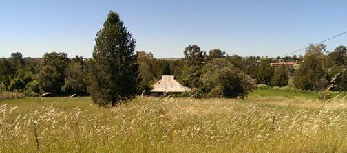
Photo
1 View of the subject site from the street behind showing the
riverside context.
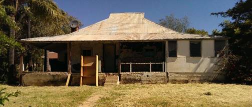
Photo
2 The Front North elevation, noting the asymmetry and the
verandah subsidence and fill. Note the hipped roof with eastern and western
vented gablets.
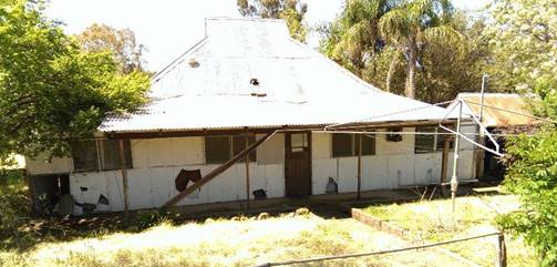
Photo
3 View of the rear of the subject property from the rear
Laneway. Note the fibro enclosed rear verandah with simple shed to the right.
While
the age of the property is more contemporary than many items of significance,
it remains a worthwhile research exercise for the Historical Society to
identify how many of this type remain in Canowindra. It may be quite rare.
In
any event, should a proposal for demolition be received and retention is not
reasonable, then a condition of consent should be that an Archival Photographic
record is made prior to demolition consistent with the NSW Heritage Division
Guidelines.
8.0 Bank
Street, Molong
RE: Works within the Conservation Area – Unauthorised
Attention: Heather Nicholls and Mark Robertson
Cabonne
Shire Council has advised the owners of buildings with awnings which overhang
public footpaths in the Shire to review the structural integrity of their
awnings.
An
unexpected consequence has been this example where the two building owners have
erected a structure to prop the edge of the awning.
The
Heritage Advisor was not consulted prior to the works.
The
owner of the Real Estate Agency is aware of the heritage issues as
consultations were undertaken prior to the Real Estate office taking up the
office space this year.
View
of the awning and the five steel posts.
The
following observations require further attention:
· There is no application recorded for the construction
of structures on public land
· There is no structural engineering advice which
supports the design and certification of these structures
· There is no application for structures within the Bank
Street Conservation Area
Observations
in relation to heritage issues within the Conservation Area
· The building is an Inter war brick structure and has
contributory value within the streetscape. Any works to the awning must be in
keeping with the style. The current works are not consistent with the suspended
awning style and detail. If there are structural issues with this type of
awning they are to be solved within the existing structure and supporting
building.
9.0 SUMMARY:
Annual Heritage Strategy checklist – 2016/2017
|
1
|
Heritage Committee
|
Advice to Council
|
1
|
7
|
|
|
|
|
Consultant Directory
|
|
|
|
|
|
|
Services & trades Directory
|
|
|
|
|
2
|
Heritage Study
|
Aboriginal Study
|
|
|
|
|
|
|
Statements of significance
|
|
|
|
|
3
|
Heritage Advice
|
Site visits
|
2
|
20
|
|
|
|
|
Heritage advice
|
3
|
38
|
|
|
|
|
Urban design advice
|
|
|
|
|
|
|
Pre-DA advice
|
2
|
17
|
|
|
|
|
Advice on DA's
|
|
8
|
|
|
4
|
Pro-active Management
|
Heritage DCP
|
|
|
|
|
|
|
Urban design DCP
|
|
|
|
|
|
|
DA fee relief
|
|
|
|
|
|
|
Flexible Planning &
building
|
|
28
|
|
|
5
|
Local Heritage Fund
|
Funded projects
|
|
|
|
|
|
|
Project value
|
|
|
|
|
|
|
Heritage fund value
|
|
|
|
|
|
|
Owner contribution
|
|
|
|
|
|
|
Tourism projects
|
|
2
|
|
|
6
|
Main Street
|
Committee
|
|
|
|
|
|
|
Study
|
|
|
|
|
|
|
Implementation
|
|
|
|
|
|
|
Expanded main street
|
|
|
|
|
7
|
Education & promotion
|
Brochures, web, plaques, panels
|
|
2
|
|
|
|
|
Events
|
|
|
|
|
|
|
Tourism strategy
|
|
2
|
|
|
|
|
Trails
|
|
|
|
|
|
|
Training
|
|
|
|
|
8
|
Council assets
|
Asset management plans
|
|
1
|
|
|
|
|
CMP and CMS
|
|
|
|
|
|
|
Works budgets
|
|
8
|
|
|
9
|
Sustainability
|
Adaptive re-use
|
|
4
|
|
|
|
|
Restoration
|
1
|
5
|
|
|
|
|
Reinstatement
|
|
3
|
|
|
|
|
Landscape
|
|
4
|
|
|
|
|
Water
|
|
|
|
David
Scobie RAIA
Cat 1 remediation shall not be approved without a satisfactory RAP and Site
Audit if deemed necessary.