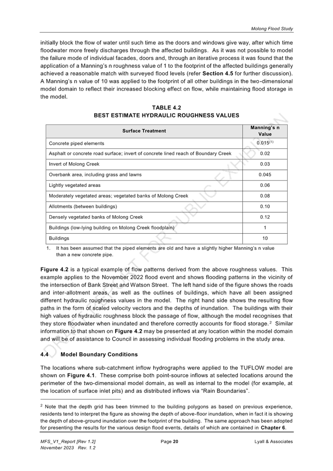
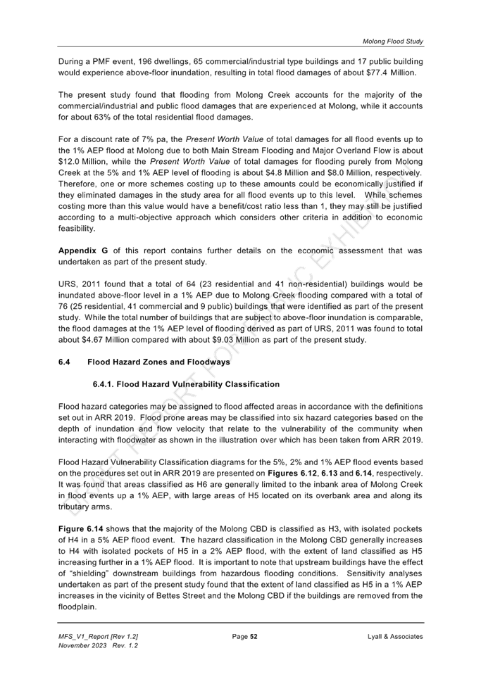
ITEM 18 - FUNDING STRATEGIC WATER PLANNING
REPORT IN BRIEF
|
Reason For Report |
To seek approval from council to transfer money from the Water Reserves to fund additional strategic works |
|
Policy Implications |
Procurement policy |
|
Budget Implications |
Cost of these strategic plans have not been included in the 24FY water budget. It is proposed to fund the costs of these plans from the Water Reserves. |
|
IPR Linkage |
2.4.2.2a - Work with Orange City Council and Central Tablelands Water to develop a regional town water supply strategy. |
|
Annexures |
Nil |
|
File Number |
\OFFICIAL RECORDS LIBRARY\WATER SUPPLY\PLANNING\SAFE AND SECURE WATER PROGRAM - 1631154 |
|
Previous Items |
4 - SAFE AND SECURE WATER PROGRAM TRANCHE 3 - MOLONG WATER SECURITY - Council - 28 Feb 2023 2:00PM 20 - STRATEGIC WATER REVIEW - Council - 22 Jun 2021 2:00pm |
|
THAT Council approve the transfer $393,194 from the Water Reserve to cover the costs of the Strategic Planning not included in the 2024 financial year budget.
|
Department Leader - Urban Infrastructure's REPORT
Council will be aware of the successful applications under the Safe and Secure Water Program for both the Sub Regional Town Water Strategy and the Molong Water Security Project. Both projects are co-funded with DPIE Water and Council, being a 75% and 25% split. The projects also incur on-costs of 15%, which are not covered by the funding deed.
The Sub Regional Town Water Strategy project costs are $365,118 plus 15% on-cost $54,767 totalling $419,885 and is being delivered by Cabonne Council (CC), Orange City Council (OCC), and Central Tablelands Water (CTW) with Cabonne Council acting as the Lead Council on the project. The 25% co-contribution by Council ($91,280) is being split 3 ways between CC, OCC and CTW.
DPIE have committed to provide 75% contribution towards the project costs to an upper limit of $273,838.25.
The contribution by OCC and CTW is $30,427 each. CC will contribute $30,427 plus the on-costs $54,767, totalling $85,193.
Molong Water Security (MWS) Project was budgeted to be $770,000 plus 15% on-cost $115,500 totalling $885,500. DPIE Water have contributed 75% of the project costs to an upper limit of $577,500.
CC is responsible for 25% of the project costs plus 15% on-costs. CC contribution totals $308,000 consisting of $192,500 project costs and $115,500 on costs.
Summary Table
|
Contribution |
Project |
Totals |
|
|
SRTWS |
MWS |
||
|
DPE Contribution |
$273,838 |
$577,500 |
$851,338 |
|
Councils contribution |
$91,280* |
$192,500 |
$222,927 |
|
Project Totals |
$365,118 |
$770,000 |
$1,135,118 |
|
On-cost to General Fund 15% |
$54,767 |
$115,500 |
$170,267 |
|
Project Total inc. On-Costs |
$419,885* |
$885,500 |
$1,305,383 |
|
CC Water Reserves required to cover the difference |
$308,000* |
$85,194 |
$393,194 |
* CC contribution to the SRTWS is 1/3 of the total Council contribution being $30,427.
It is proposed to fund the $222,927 (Counci’ls contributions) and $170,267 (on- costs) totalling $393,194 from the Water Reserves to deliver these two projects. OCC and CTW will provide $60,853 towards the project.
ITEM 19 - FUNDING EMERGENCY SEWER WORKS
REPORT IN BRIEF
|
Reason For Report |
To seek approval from council to transfer monies from the Sewer Reserves to fund emergency works. |
|
Policy Implications |
Procurement |
|
Budget Implications |
Cost of these works are not covered in the 24FY sewer budget. It is proposed to fund these costs from Sewer Reserves. |
|
IPR Linkage |
2.3.1.2a - Maintain in accordance with the Strategic Asset Management Plan (SAMP), Long Term Financial Plan (LTFP) and relevent Department Plans. |
|
Annexures |
Nil |
|
File Number |
\OFFICIAL RECORDS LIBRARY\SEWERAGE AND DRAINAGE\MAINTENANCE\SEWERAGE SYSTEMS - 1630839 |
|
THAT council approve transfer of funds of $275,000 from the Sewer Reserve to cover costs associated with the urgent repairs of sewer infrastructure that is not covered in the 2024 financial year budget.
|
Department Leader - Urban Infrastructure's REPORT
Council sewerage pumping station infrastructure was damaged during the November 2022 floods in Molong, Canowindra and Eugowra. Council implemented a short-term remediation system to enable the pumping systems to continue to function in the short term. This provided council the opportunity to investigate a longer-term, robust strategy for the damaged assets. This required consideration of newer technology for the outdated electrical control and telemetry systems.
Council engaged contractors who are registered on council’s Goods and Services Tender and have expertise in this area to work with council on the options. During this time council worked with our insurer on the potential to cover these costs.
These repairs will include civil works, pipe work repairs, site fencing and the larger costs being the replacement of the pump station switchboards which included all the electrical control and telemetry components. These works are currently being commissioned and finalised.
Insurance cover was likely to only cover approx. 1/3 of the costs of these repairs and the complexities in identifying what the insurer will cover and not, caused delays. Staff in consultation with the Executive Leadership Team have determined to cover all costs for these repairs from the sewer fund and seek opportunities for reimbursement from other funding sources should they present in the future. Whilst not yet determined it is anticipated the costs of these works can be reclaimed through the recovery funding and will be a focus of council once the criteria is confirmed.
Second to this is the current failure of the Molong Sewage Treatment Plant program logic controller (PLC). The PLC failed recently causing concern for the effective treatment of the sewage at the treatment plant. The PLC operates the plant’s function and cycles automatically. The equipment required to operate the cycles of settling, decanting, pause and aeration is automated by the PLC on set times to operate 24 hrs a day, 7 days a week. Council have urgently engaged contractors to rectify these as emergency works.
The damage caused by the November 2022 event and the failure of the PLC were not forecast budget items in the sewer budget. It is therefore required to fund these works from the Sewer Reserves. The final costs will not be known until all works are completed and reconciled. However, the costs are estimated to be approximately $275,000 at completion.
It is proposed to fund the costs of the works identified above from the Sewer Reserve and report on the final costs to council through the 2nd quarter QBR in February 2024.
ITEM 20 - Draft Molong Flood Study
REPORT IN BRIEF
|
Reason For Report |
To present the draft Molong Flood Study and seek endorsement to proceed to public exhibition of the study |
|
Policy Implications |
Nil at this stage |
|
Budget Implications |
Costs of public exhibition of the plan are included with the Molong Flood Study project budget |
|
IPR Linkage |
2.2.4.1b - Complete Molong floodplain management study and plan reviews. |
|
Annexures |
1. 20231207-Molong Flood Study_V1_Report [Rev 1.2] [Red Text].pdf⇩ 2. MFS_V2_Figures_[Rev 1.1].pdf⇩ |
|
File Number |
\OFFICIAL RECORDS LIBRARY\SEWERAGE AND DRAINAGE\FLOOD MITIGATION\MOLONG FLOODPLAIN PROJECT - 1633623 |
|
THAT Council endorse the draft Molong Flood Study for public exhibition
|
Deputy General Manager - Cabonne Infrastructure's REPORT
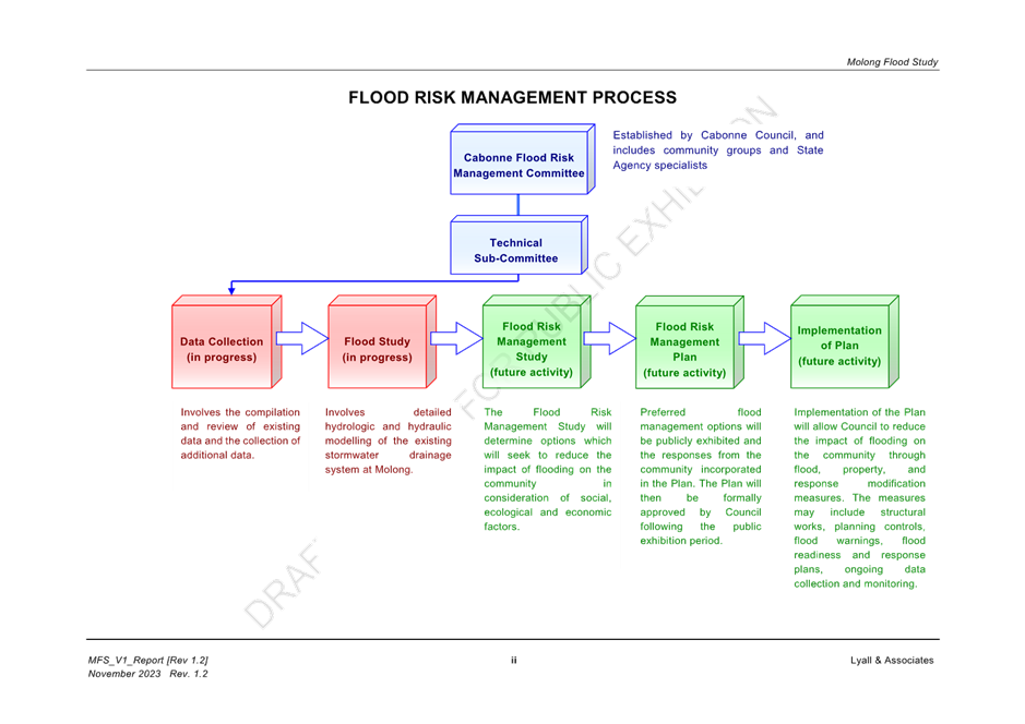
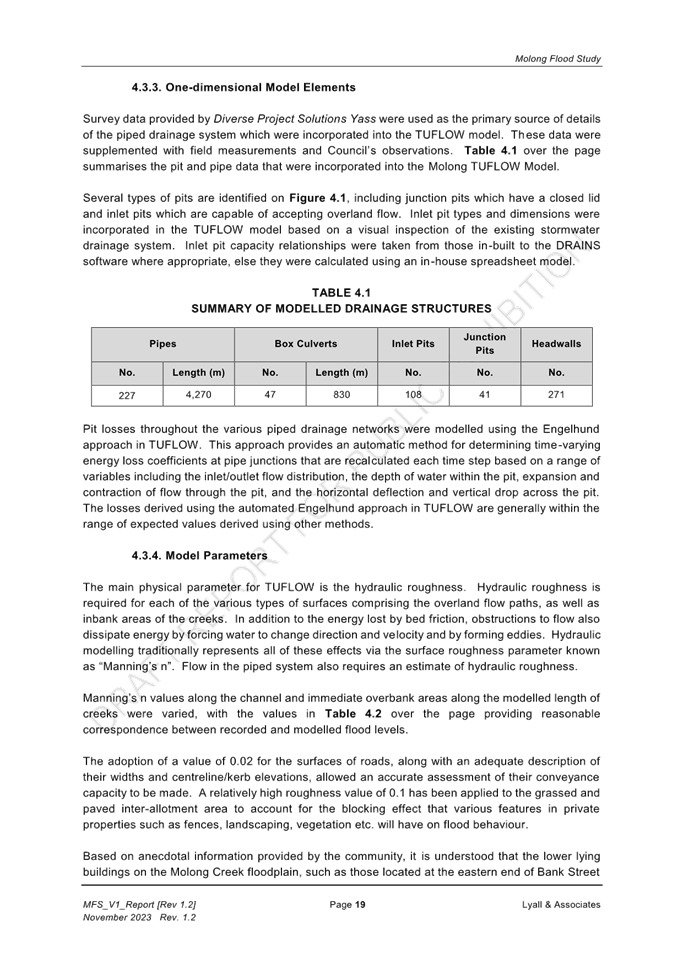
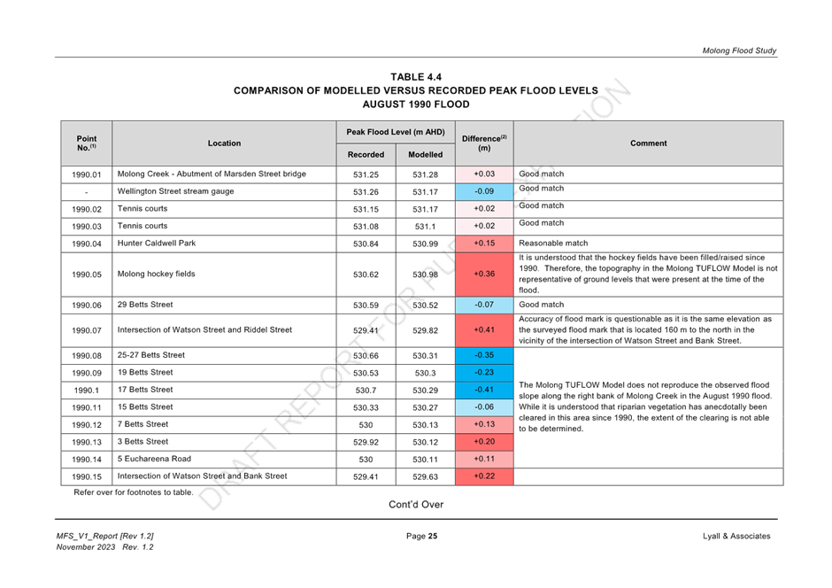
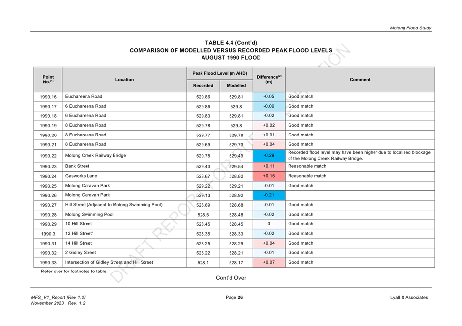
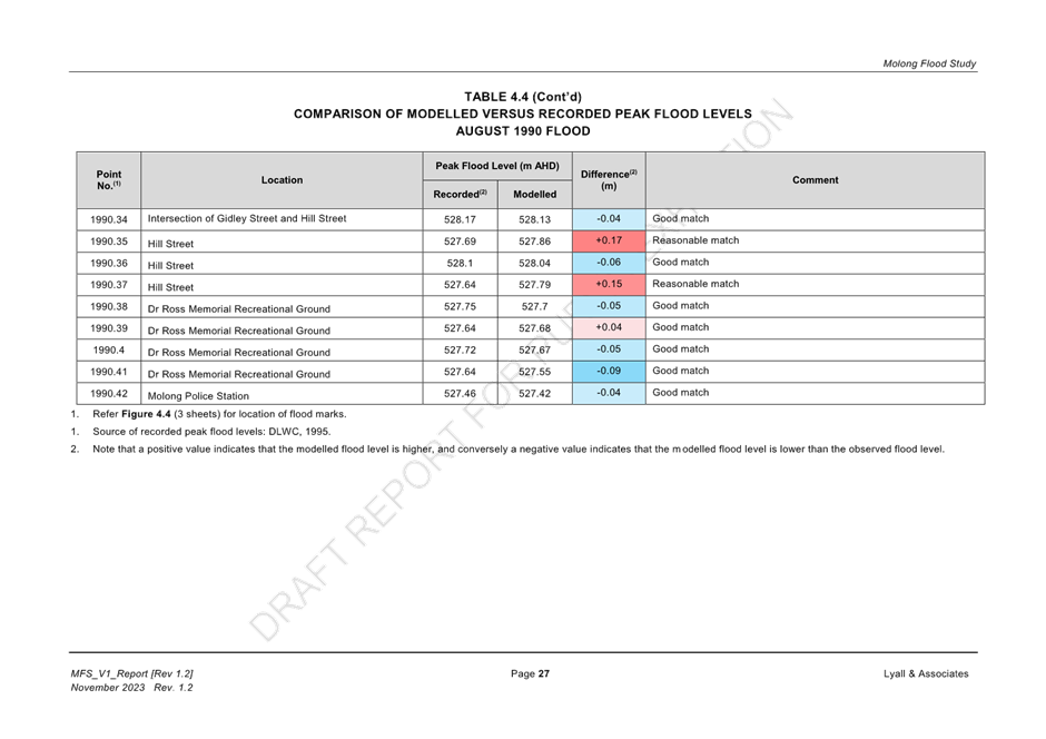
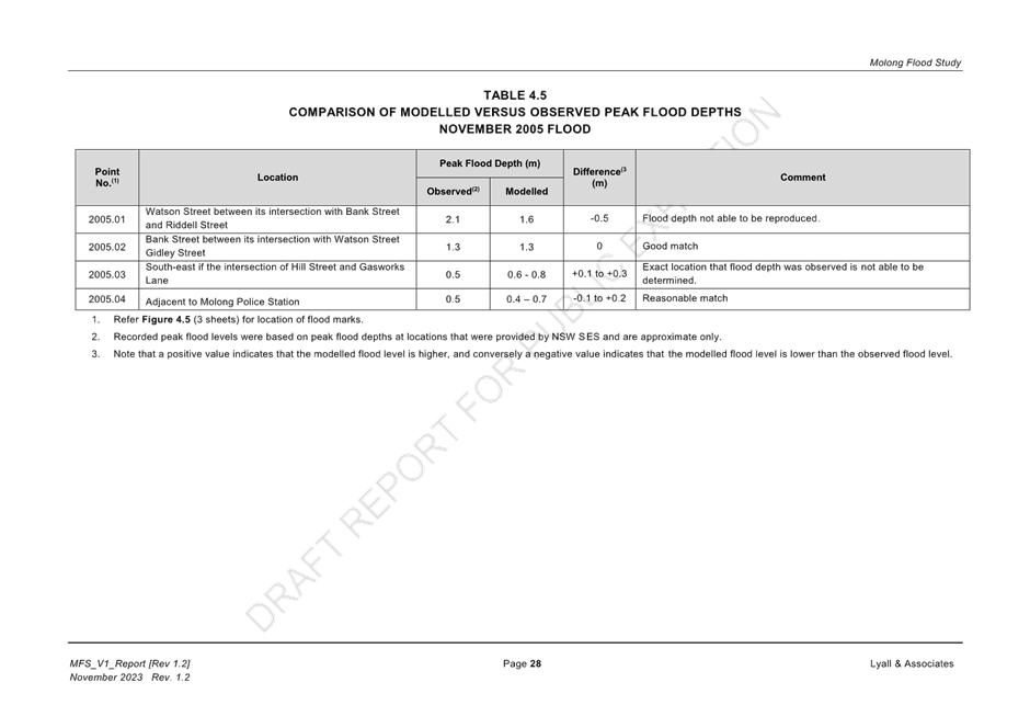
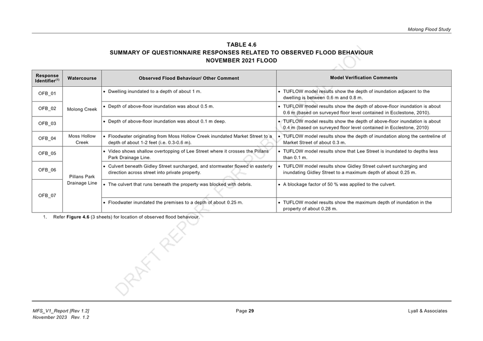
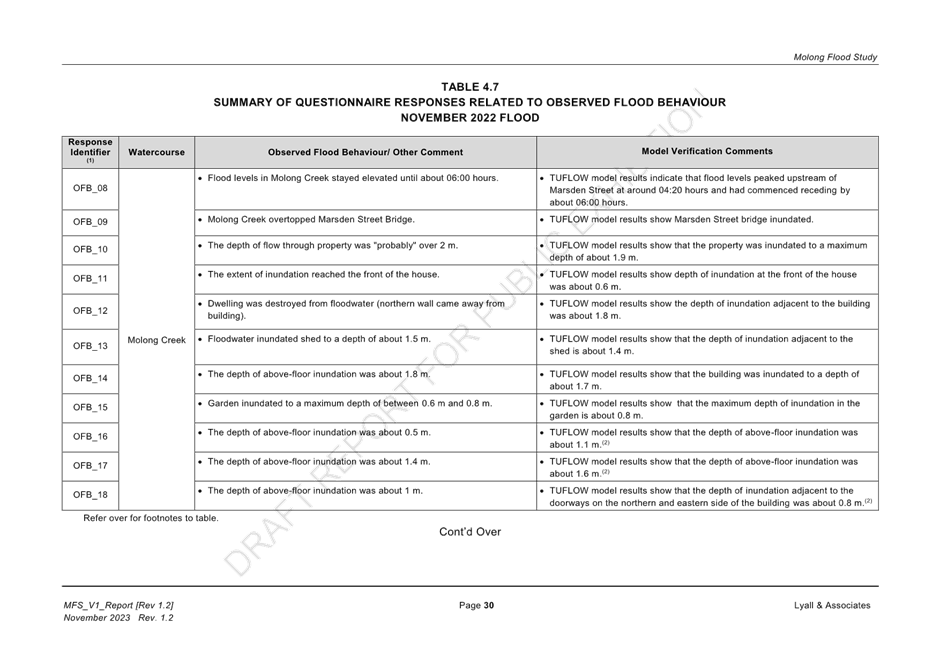
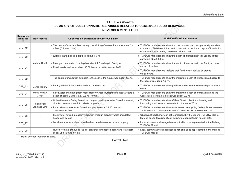
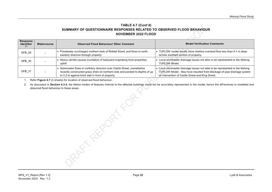
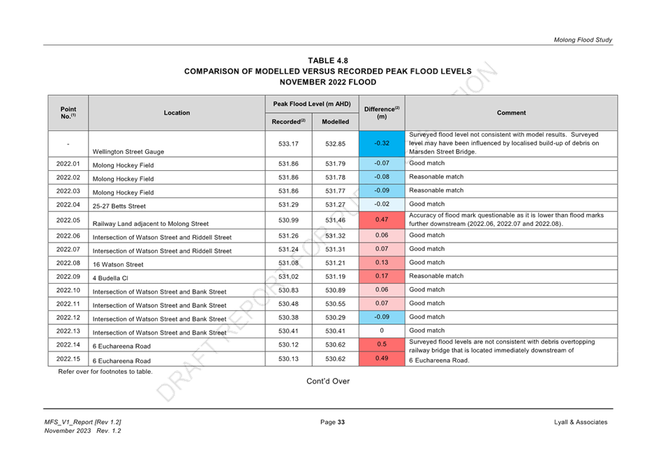
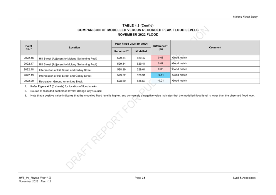
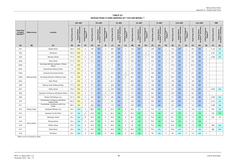
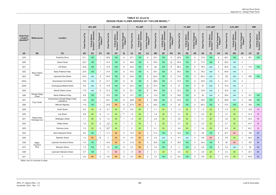
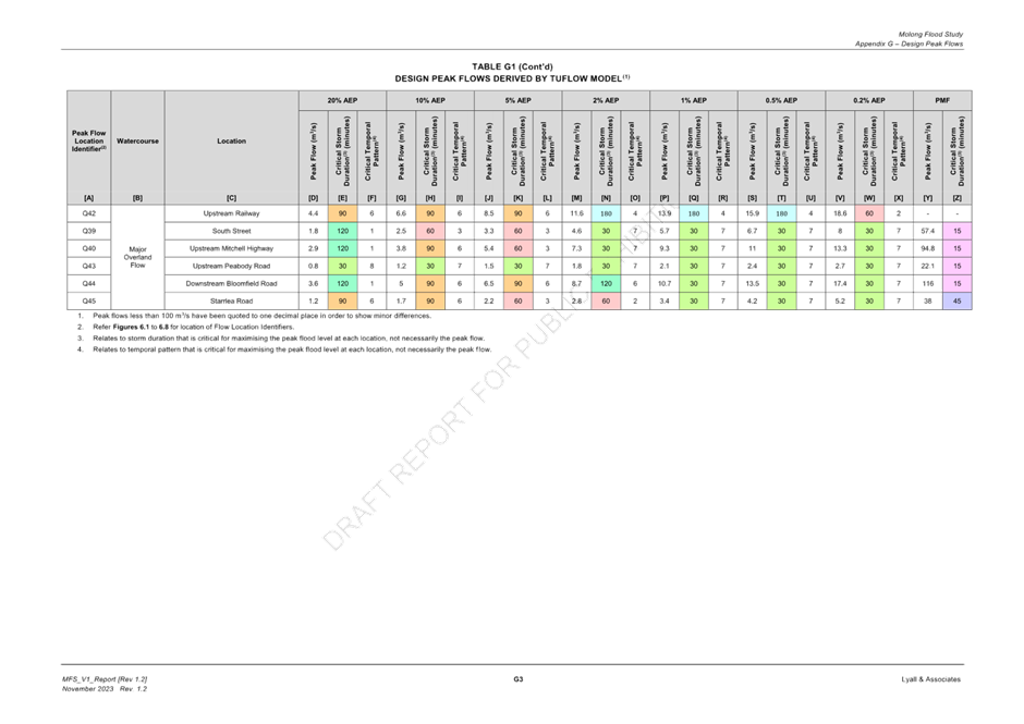
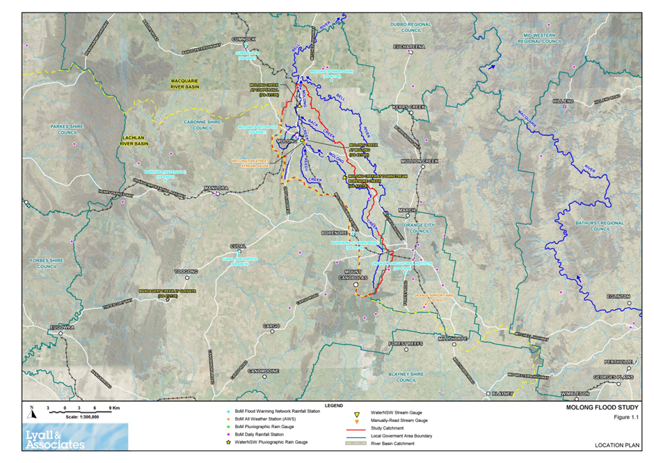
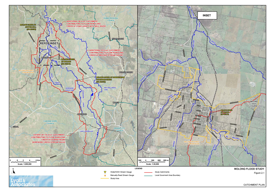
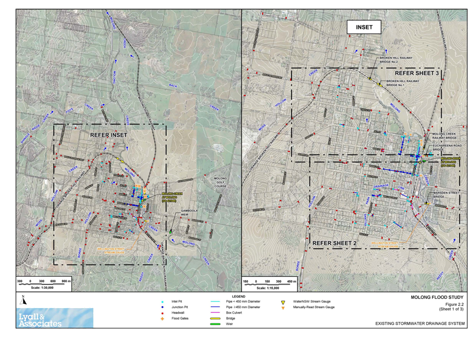
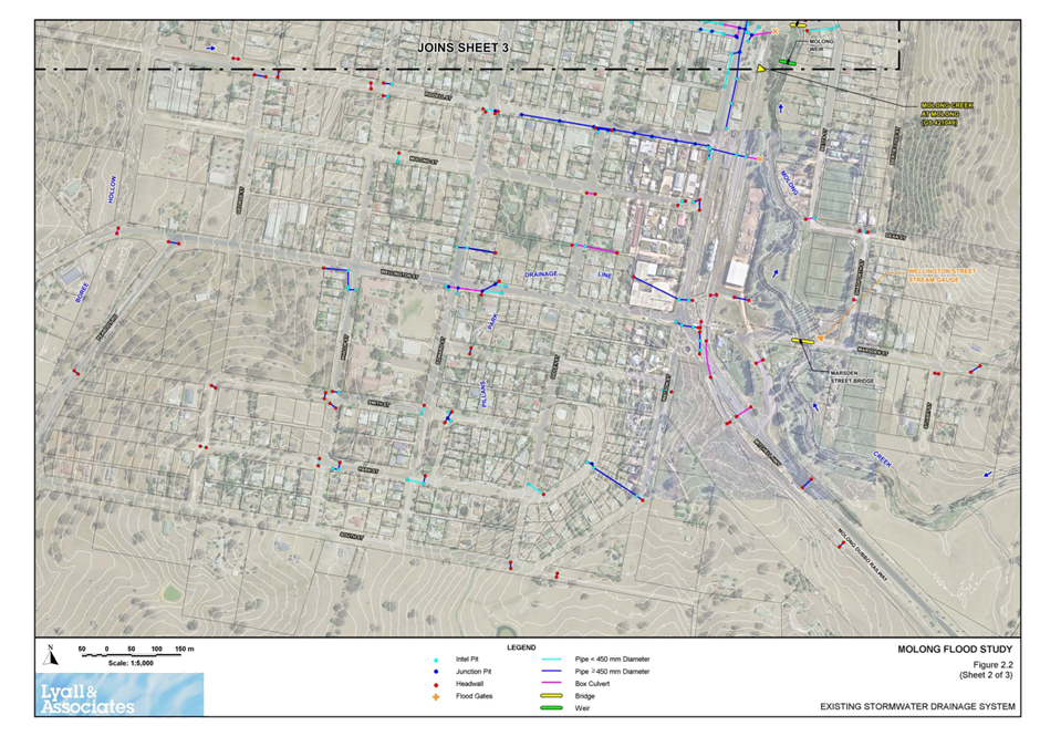
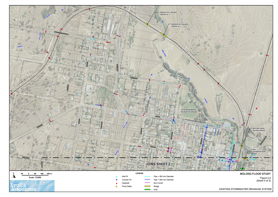
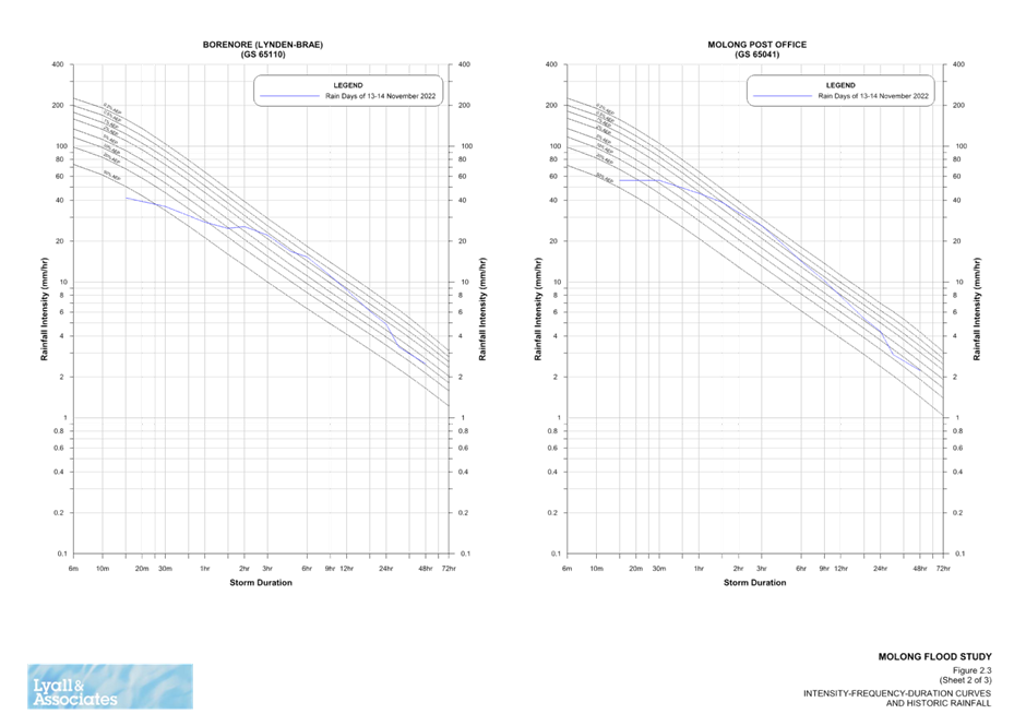
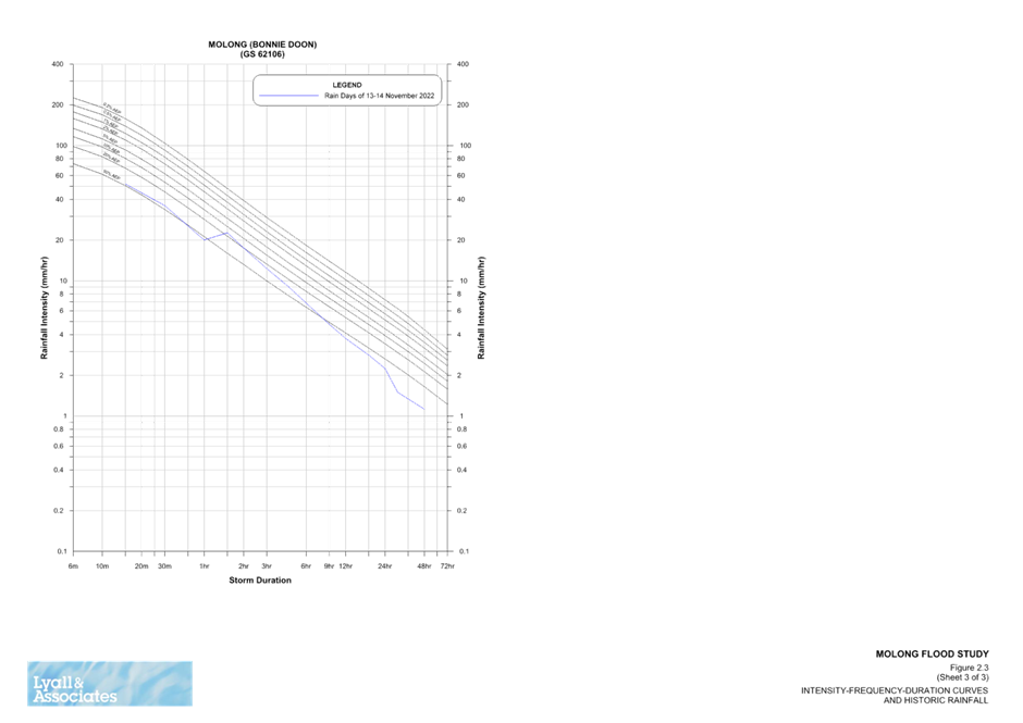
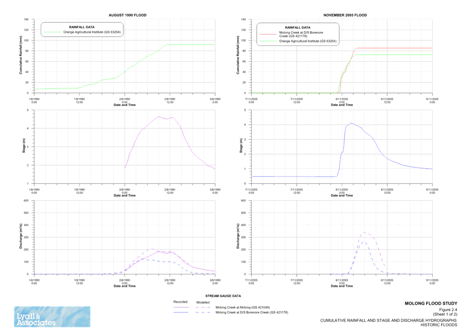
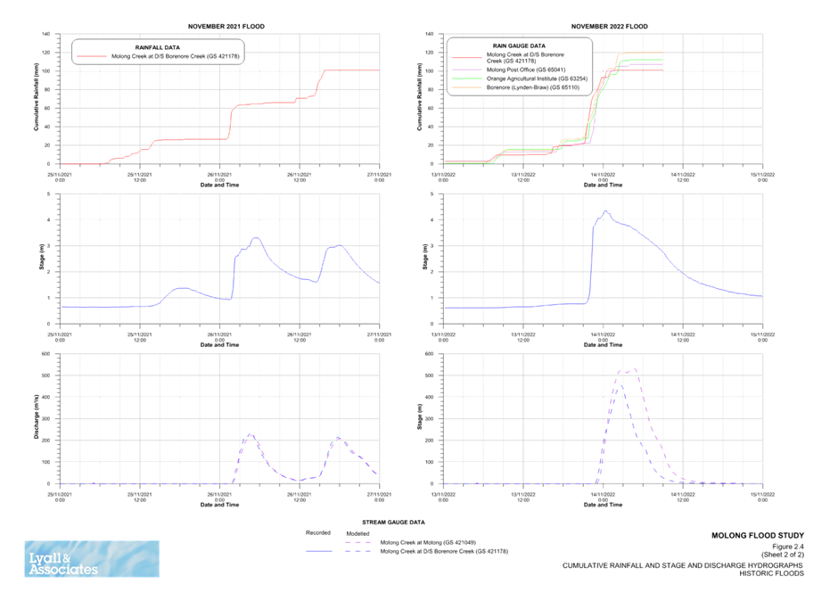
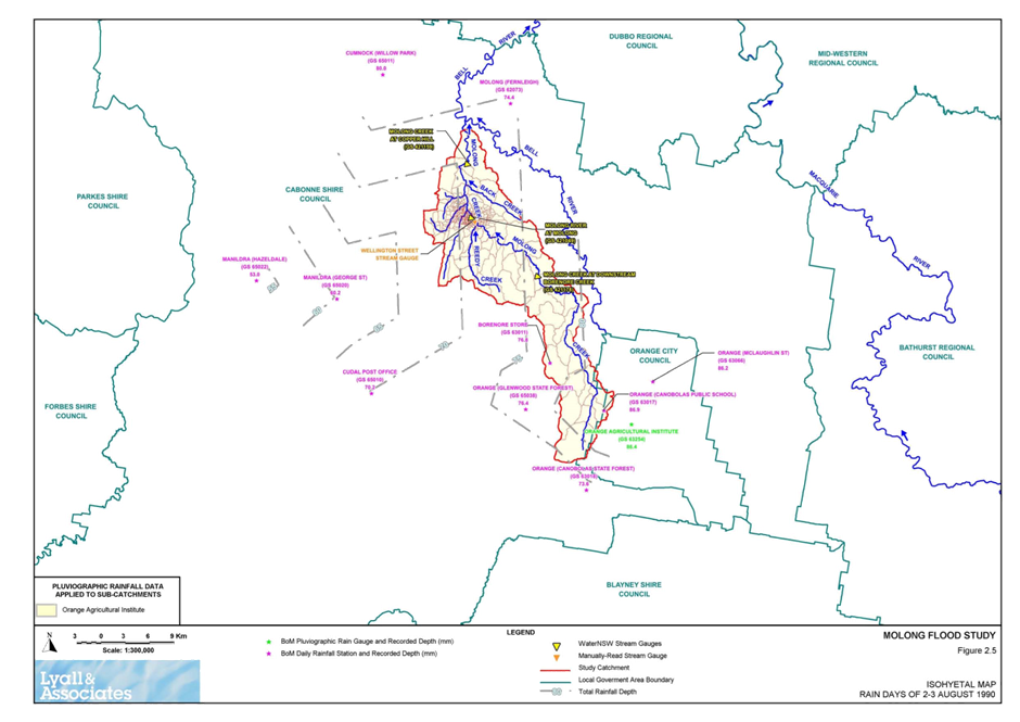
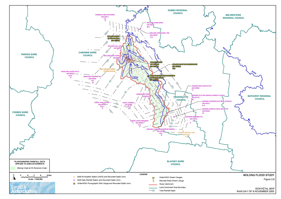
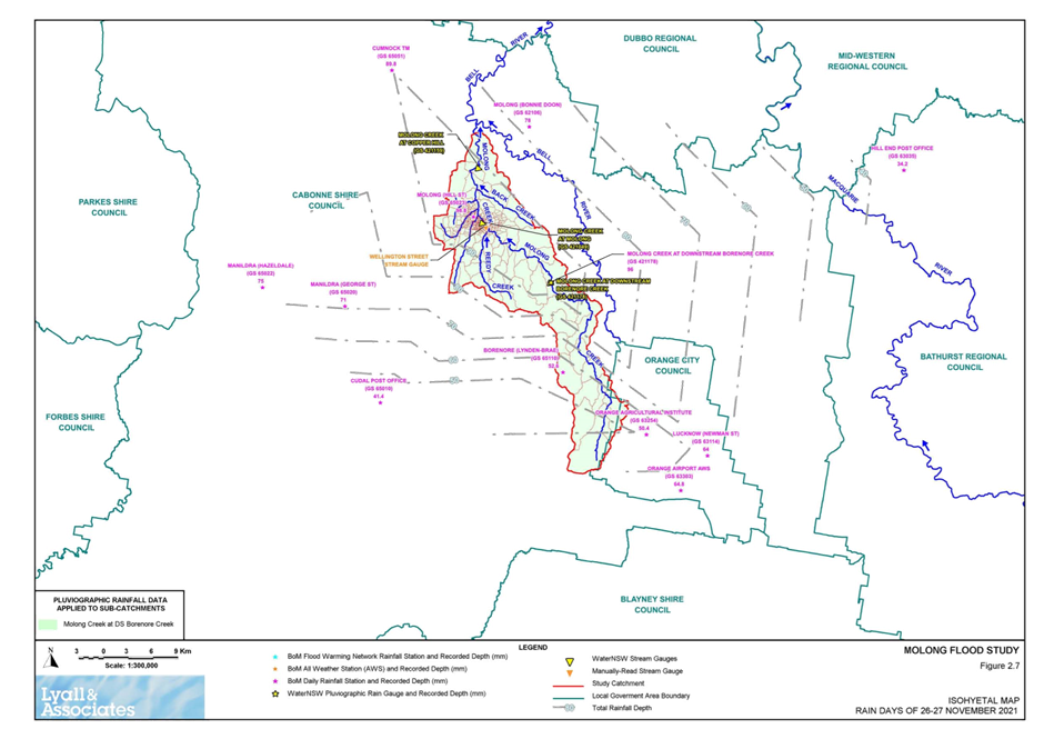
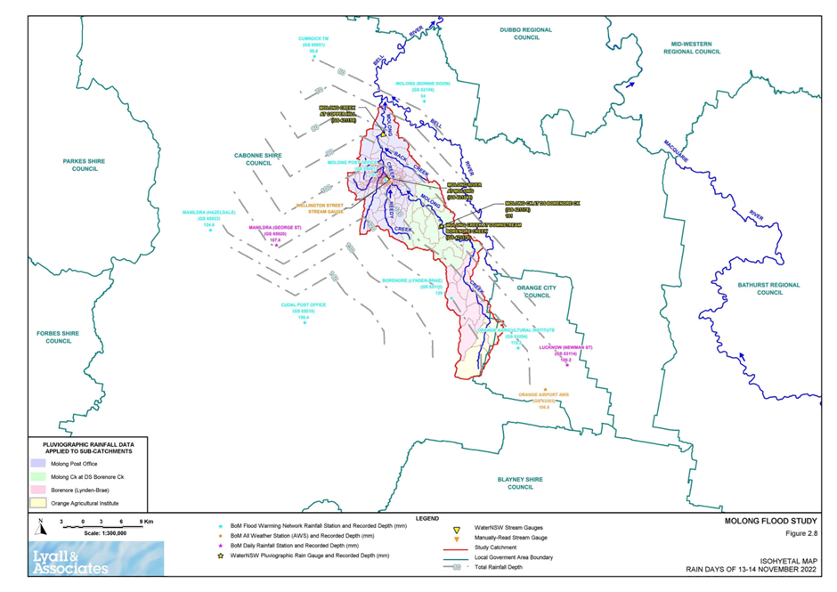
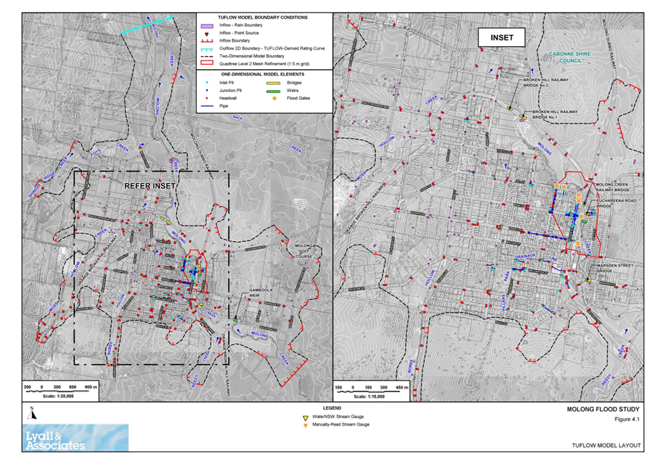
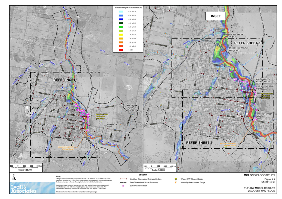
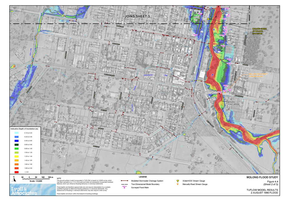
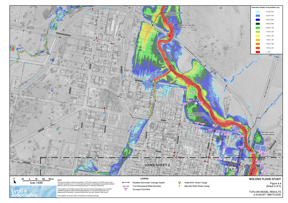
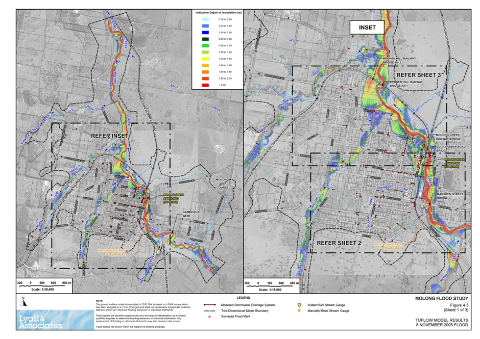
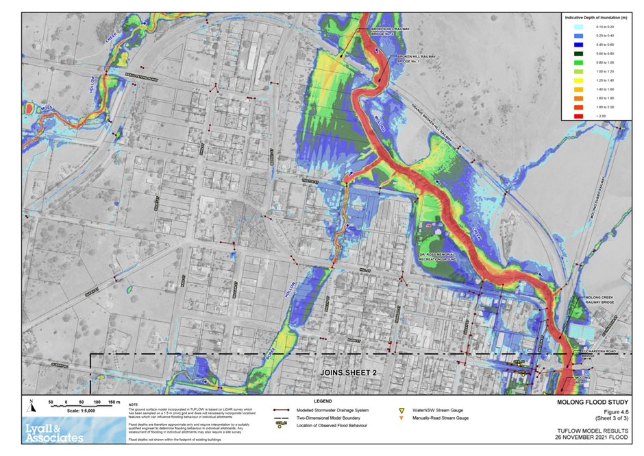
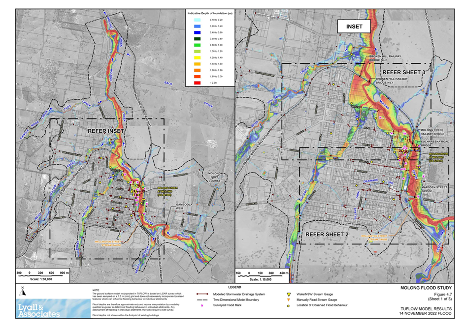
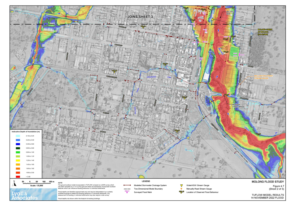
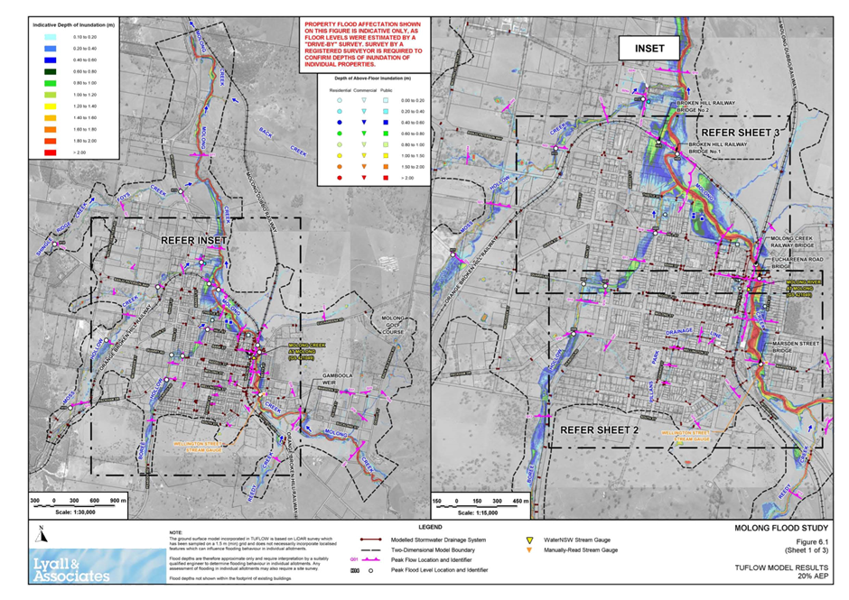
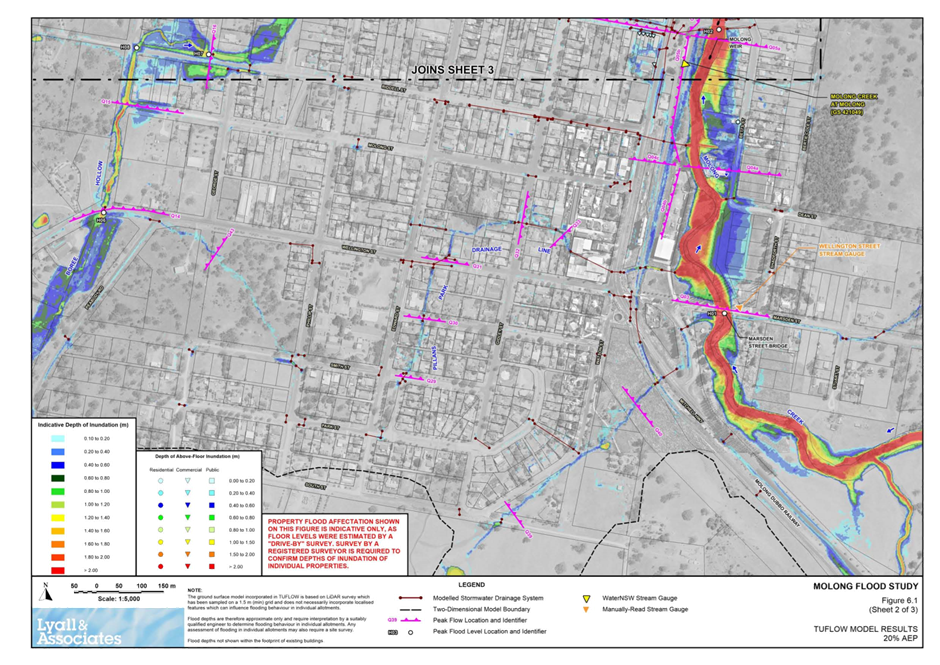
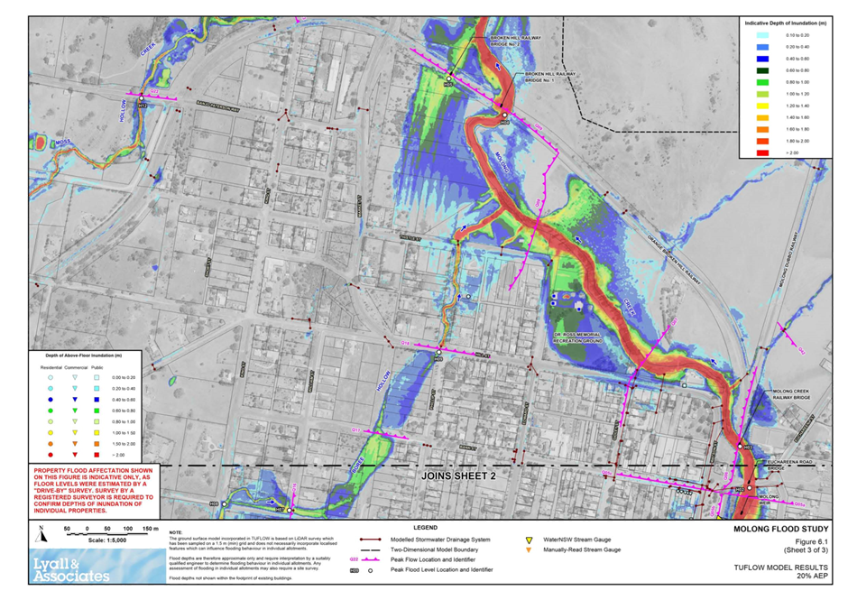
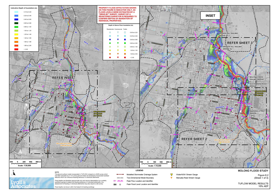
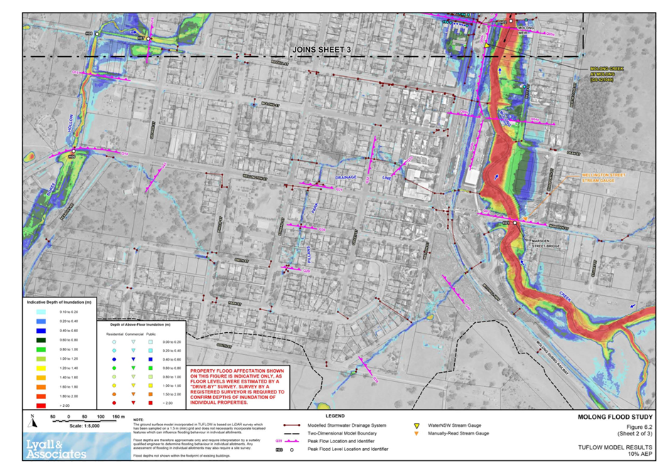
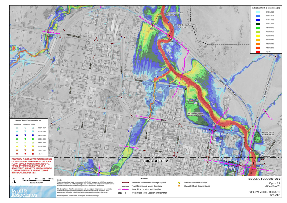
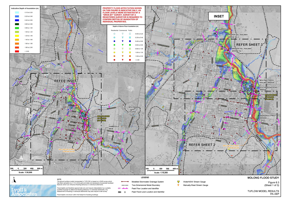
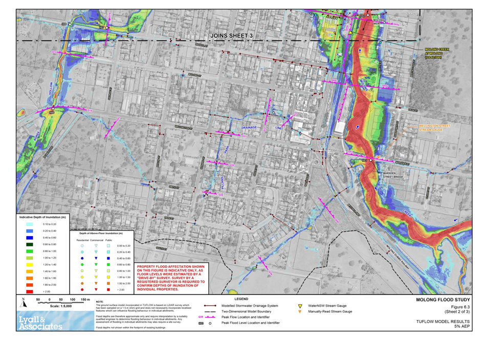
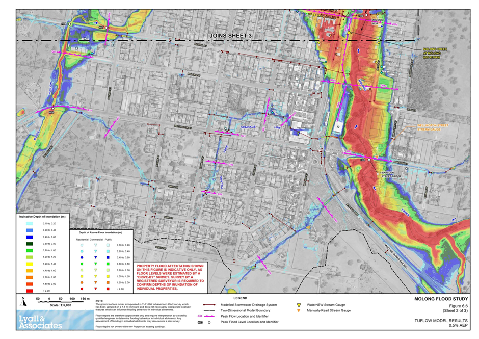
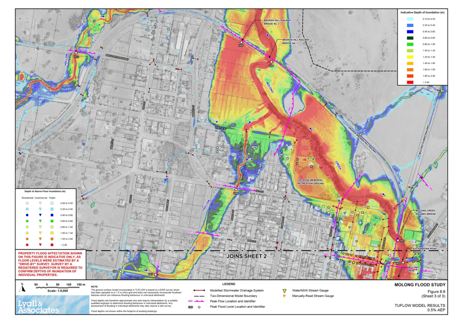
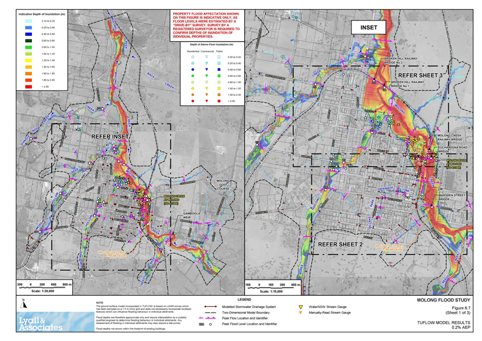
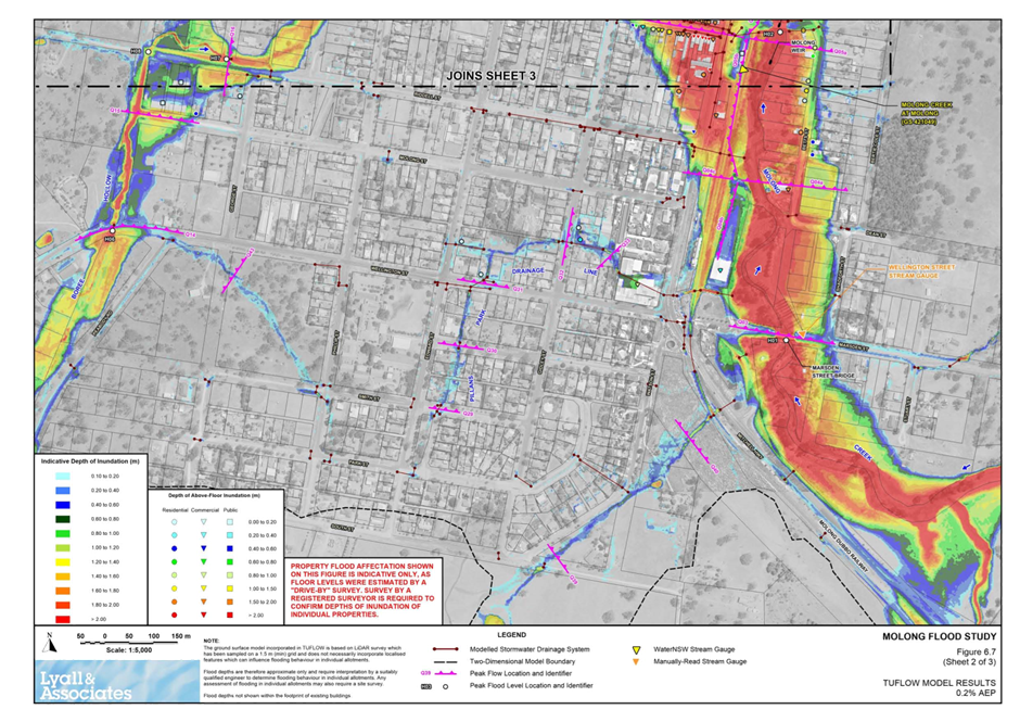
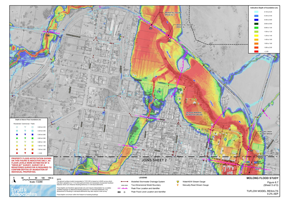
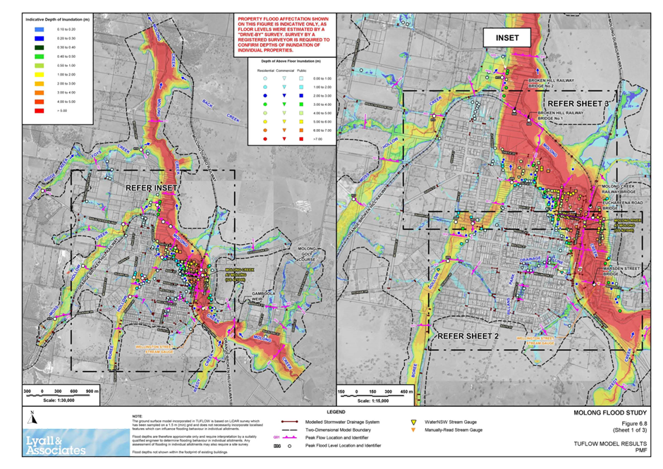
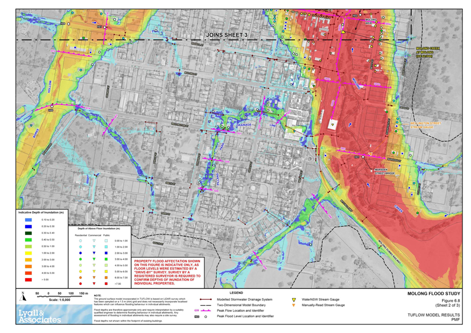
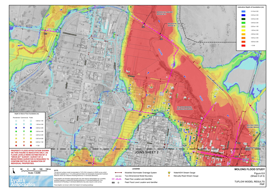
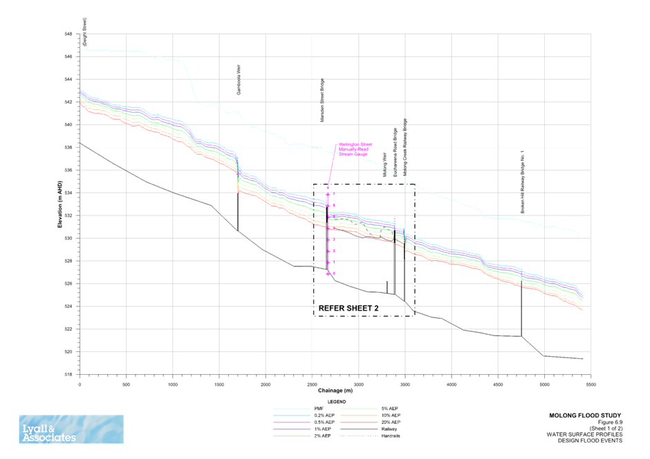
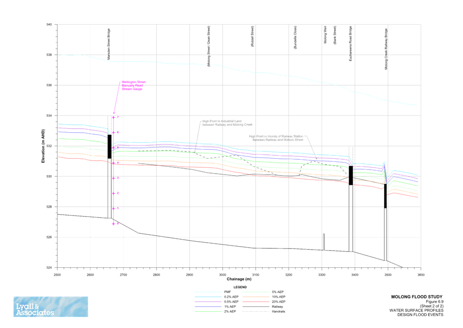
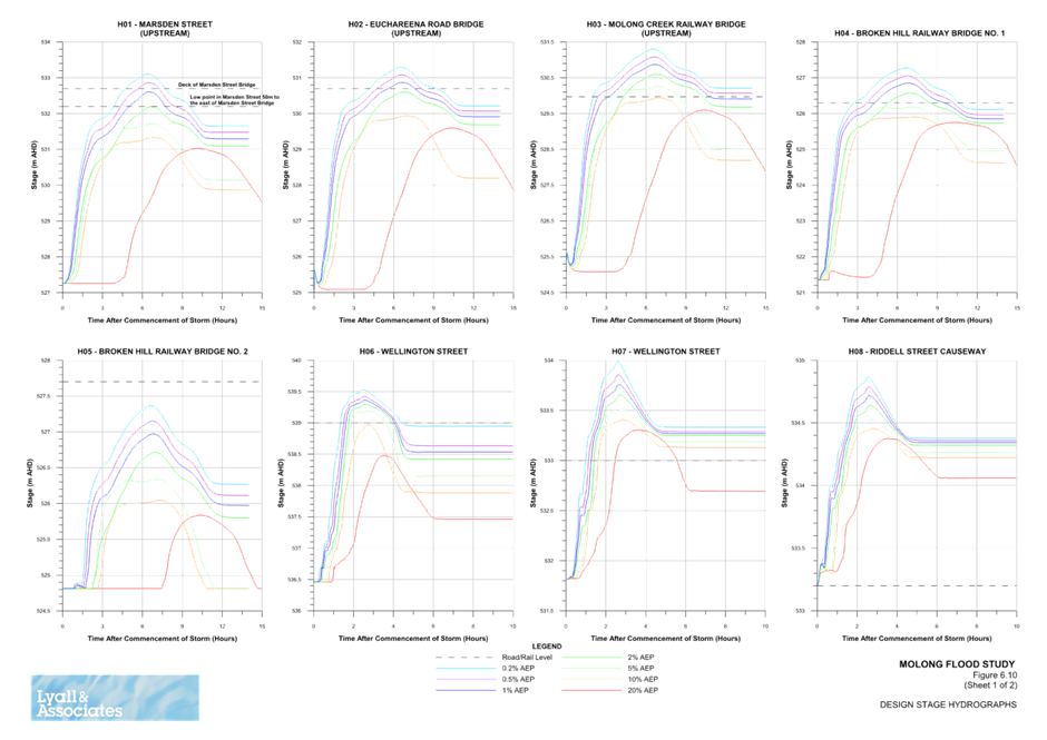
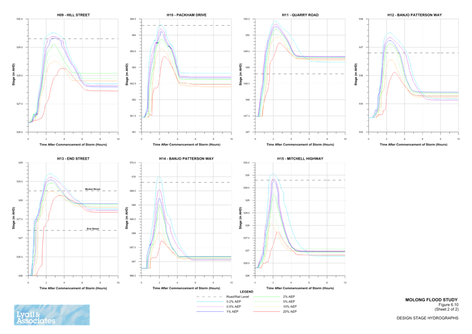
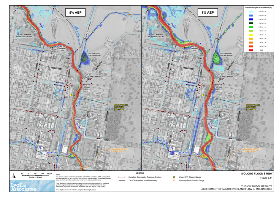
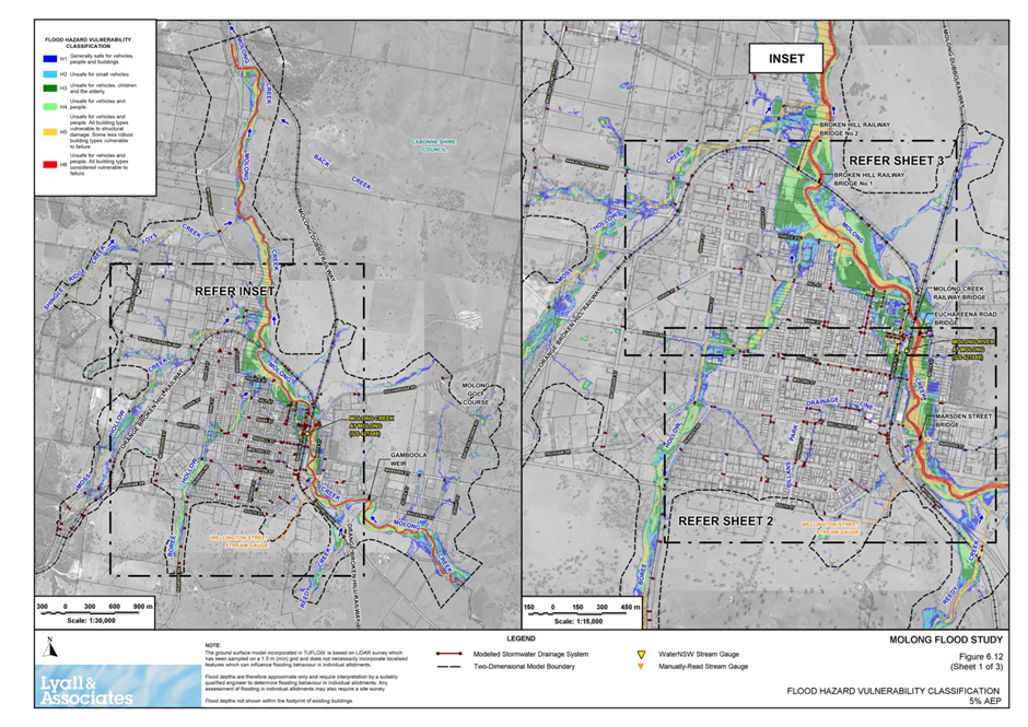
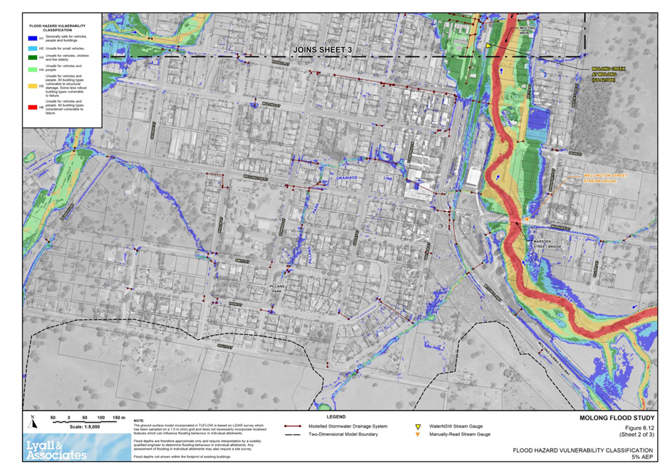
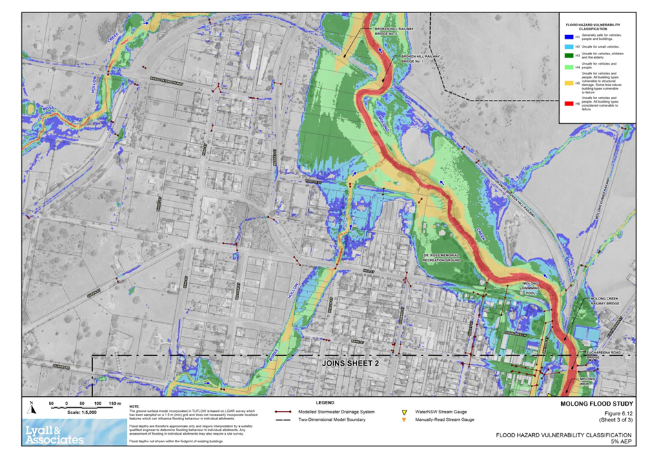
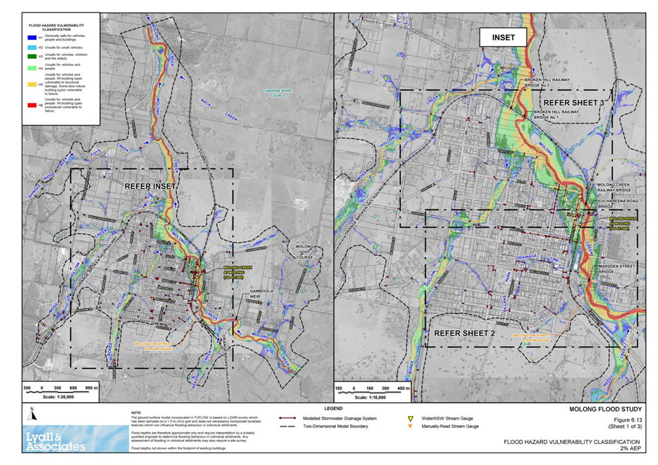
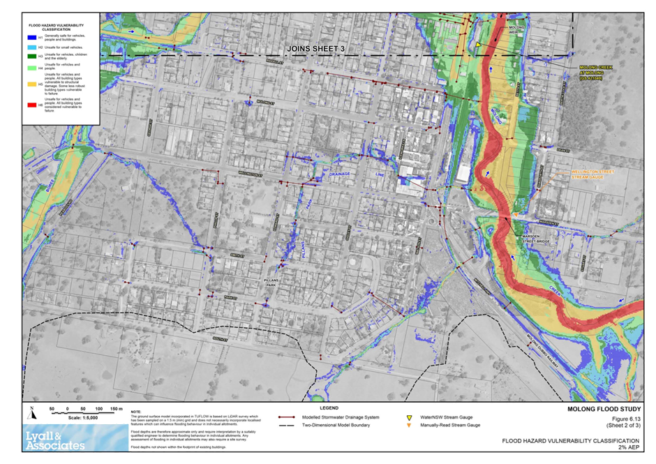
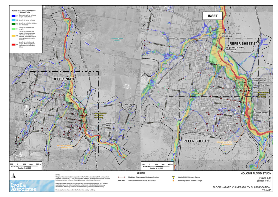
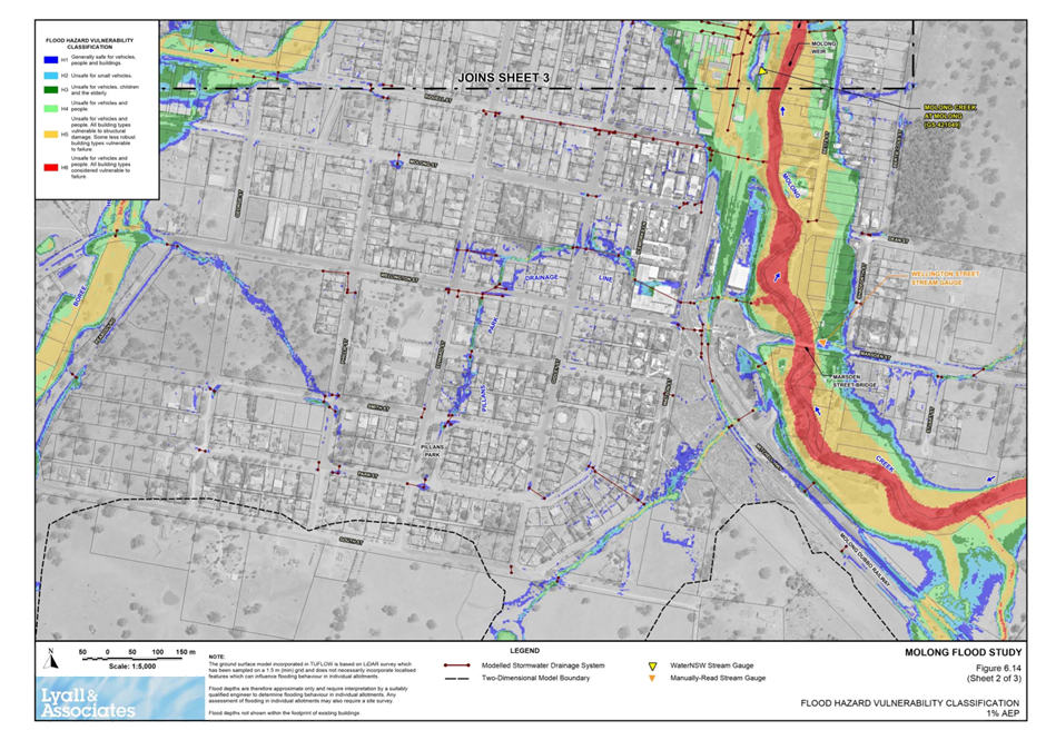
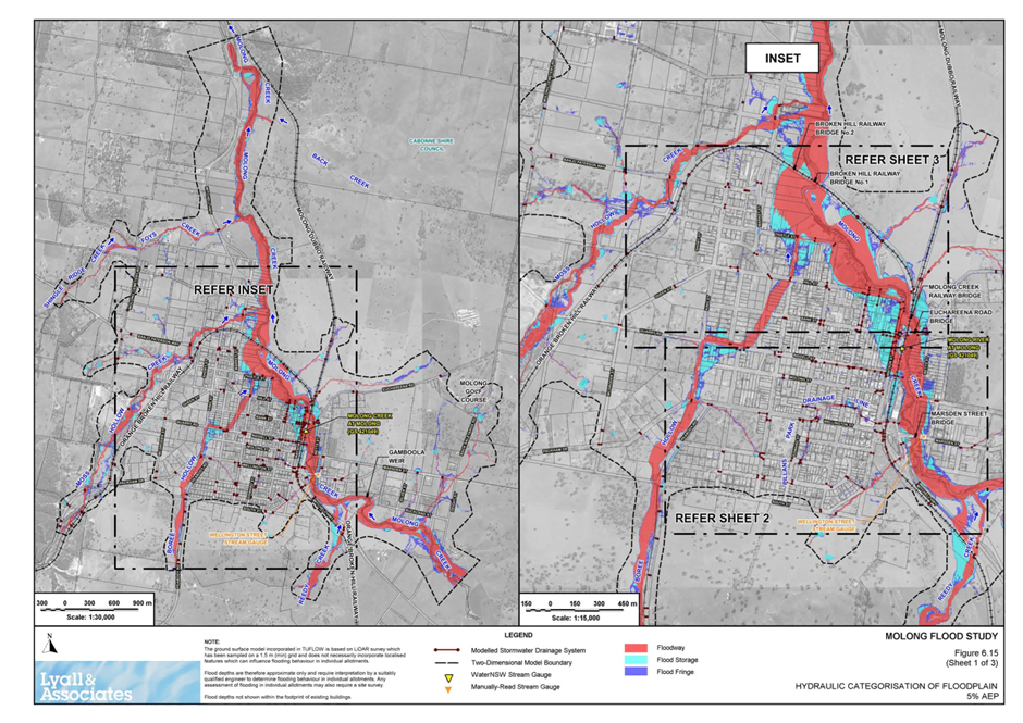
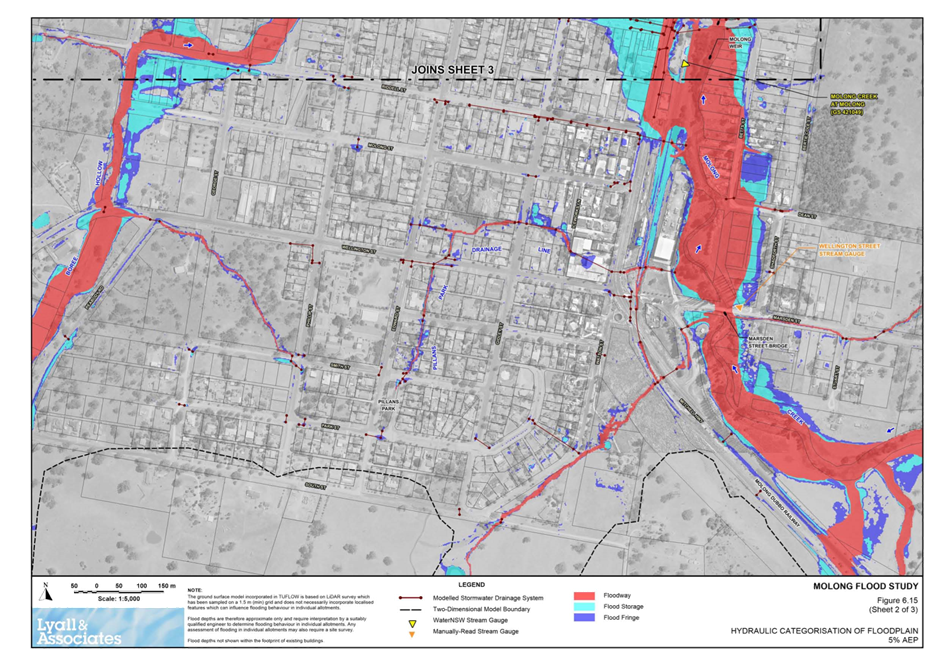
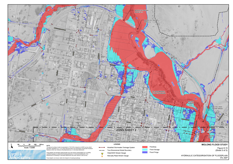
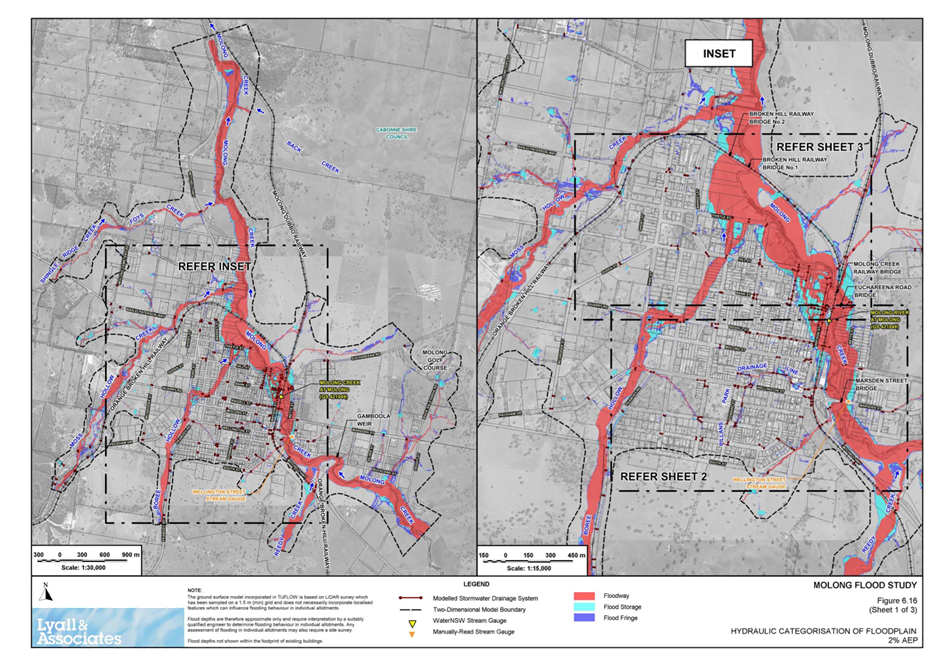
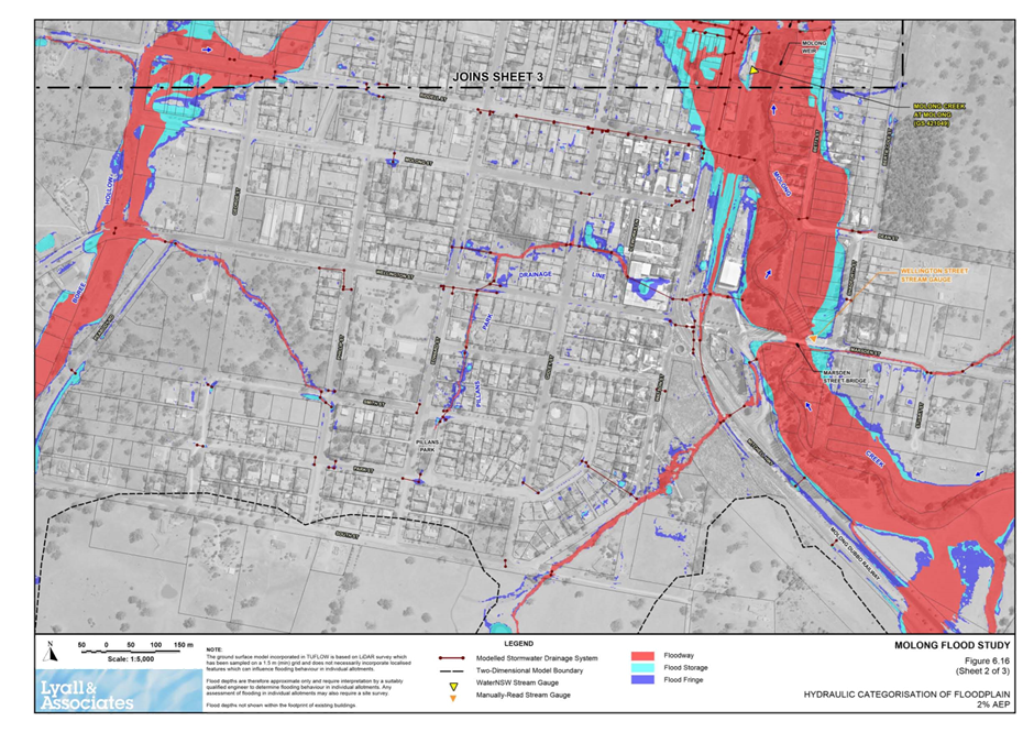
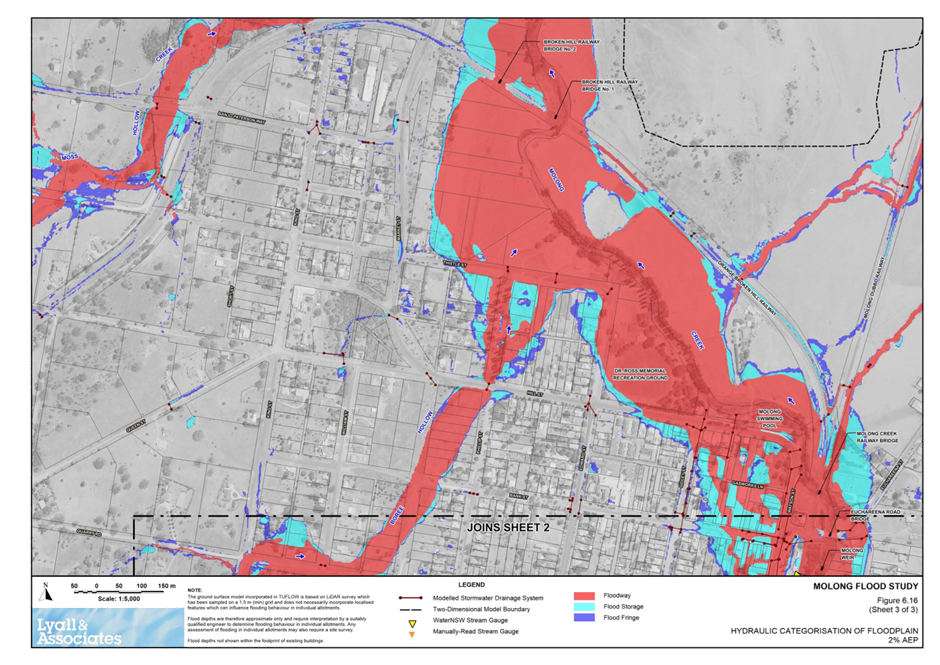
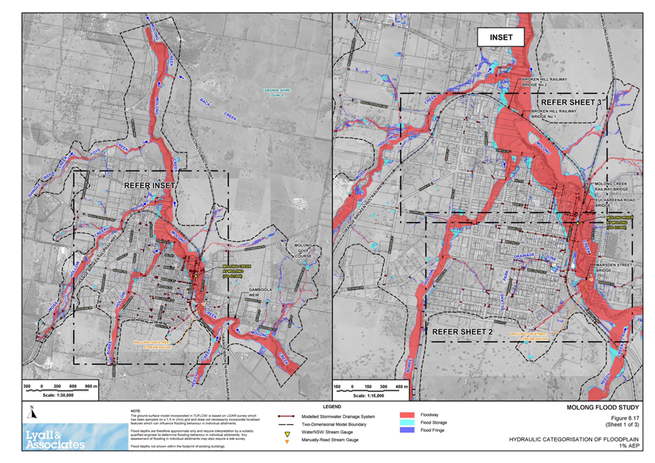
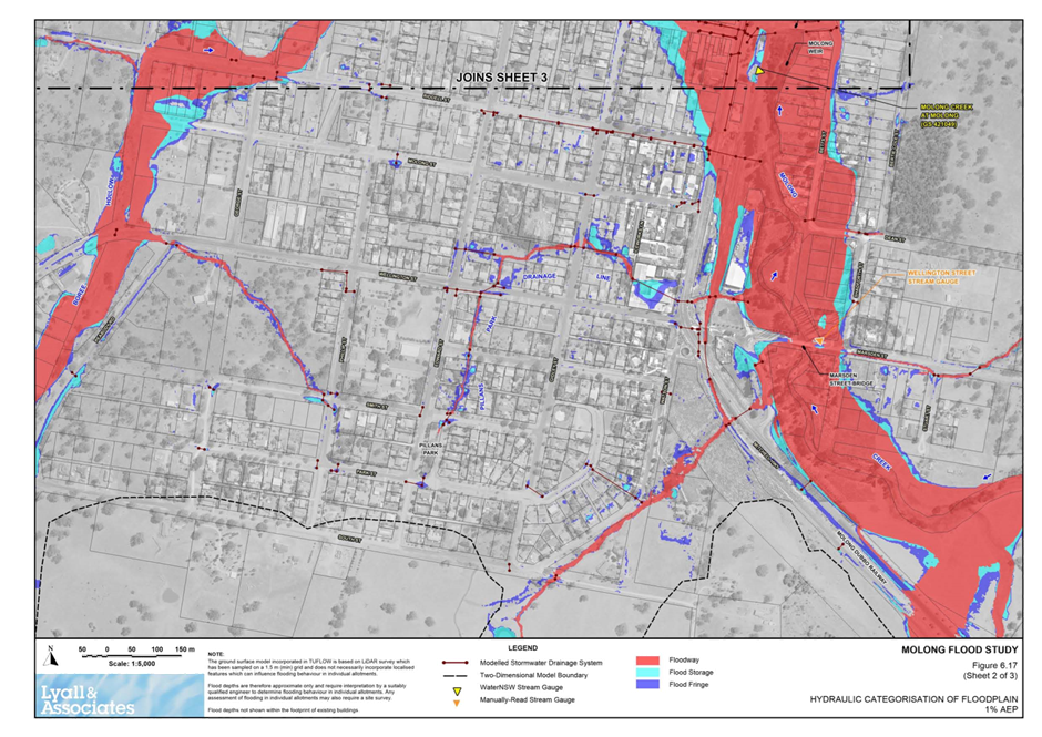
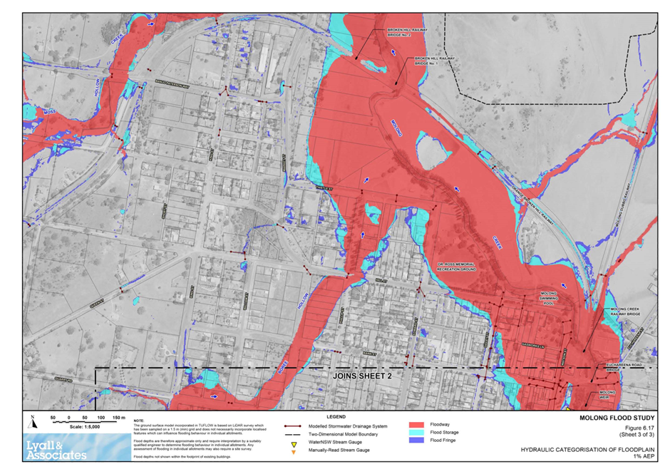
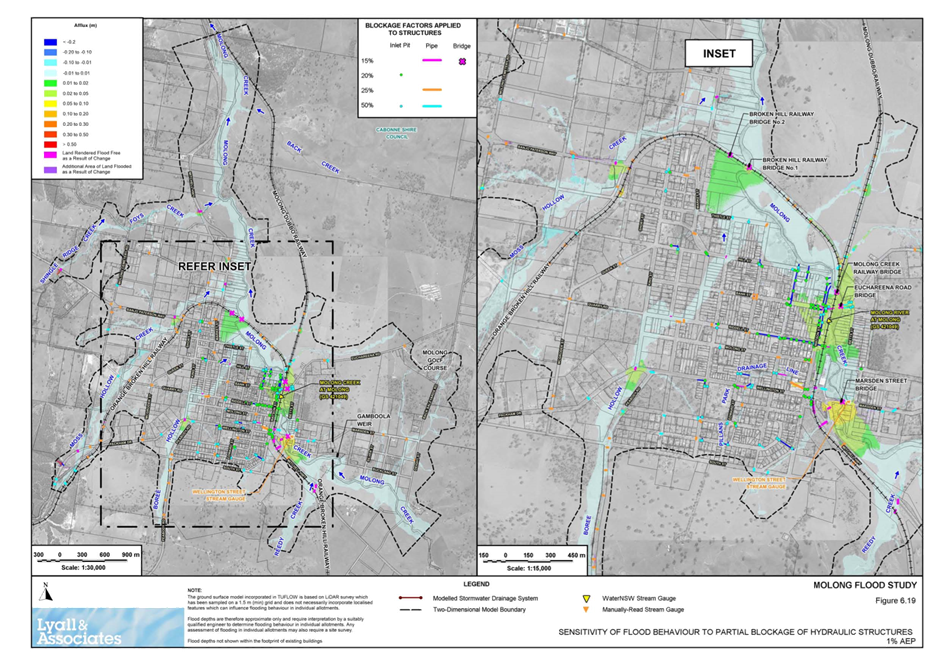
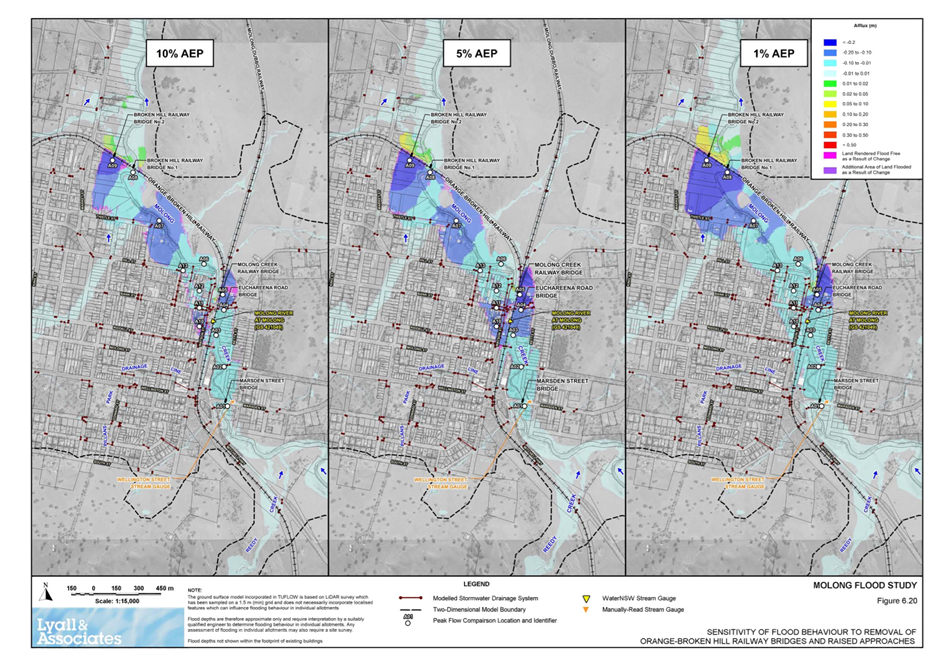
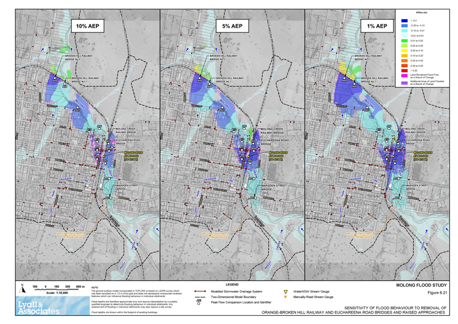
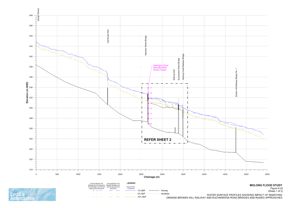
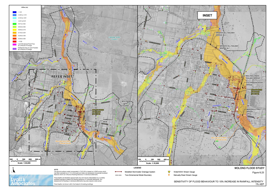
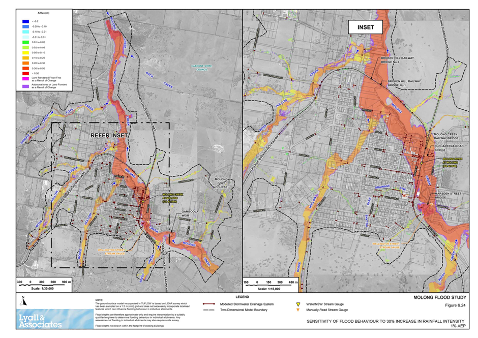
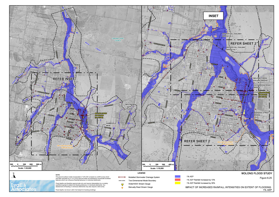
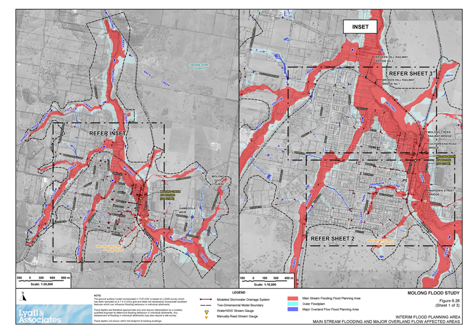
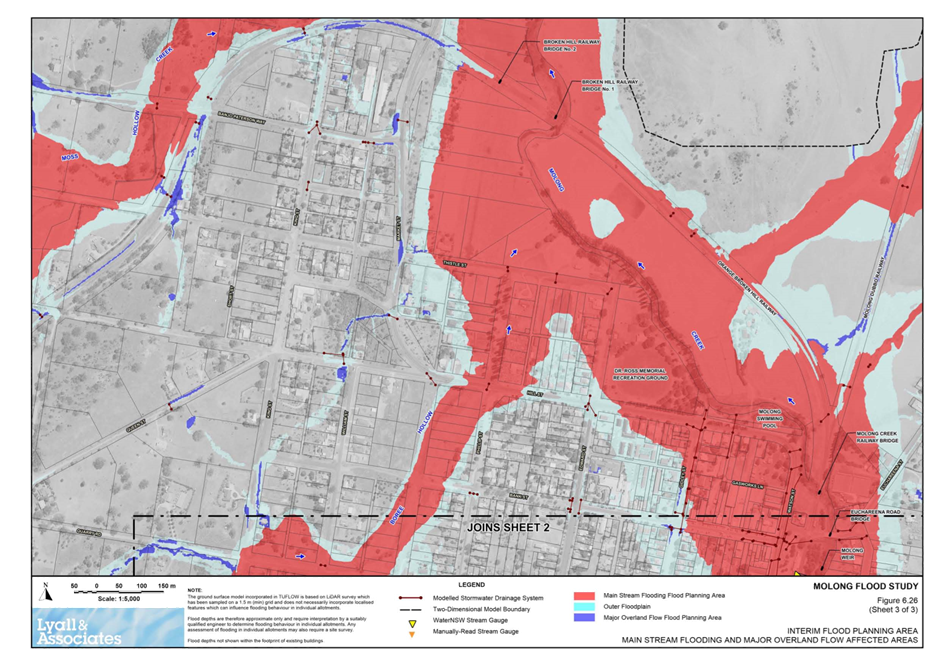
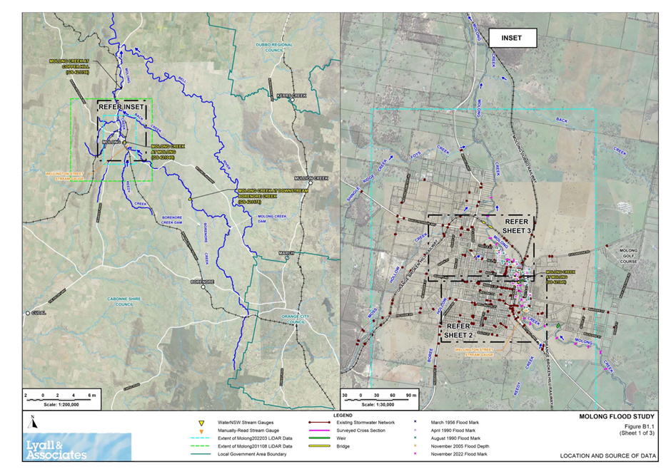
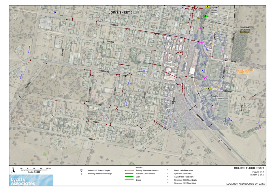
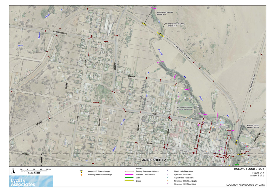
Council has been undertaking a revised and updated flood study and plan for Molong over the past year. The review has progressed to a draft flood study being completed in preparation for public exhibition.
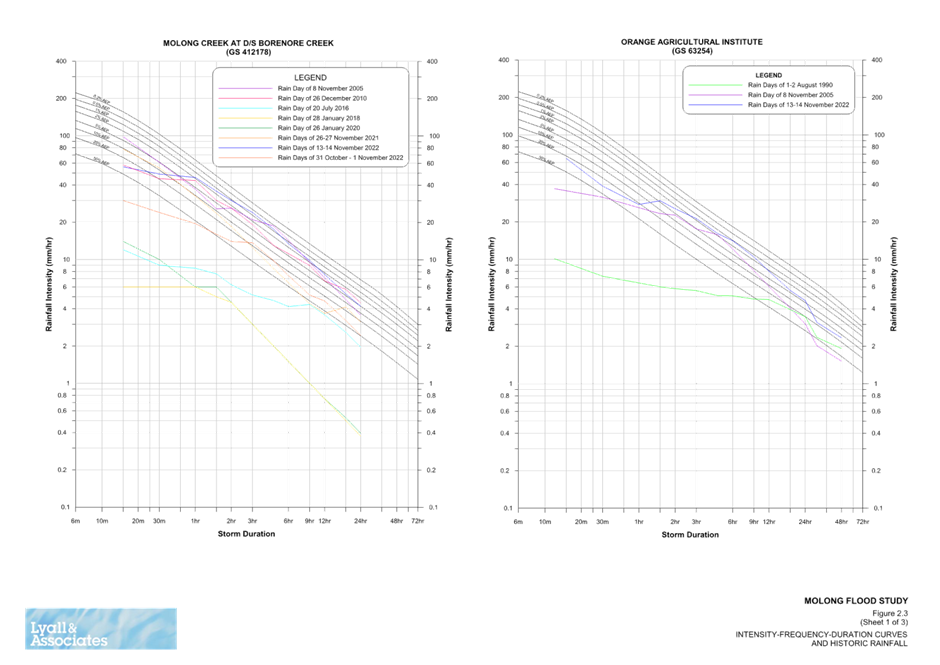
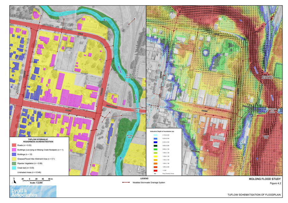
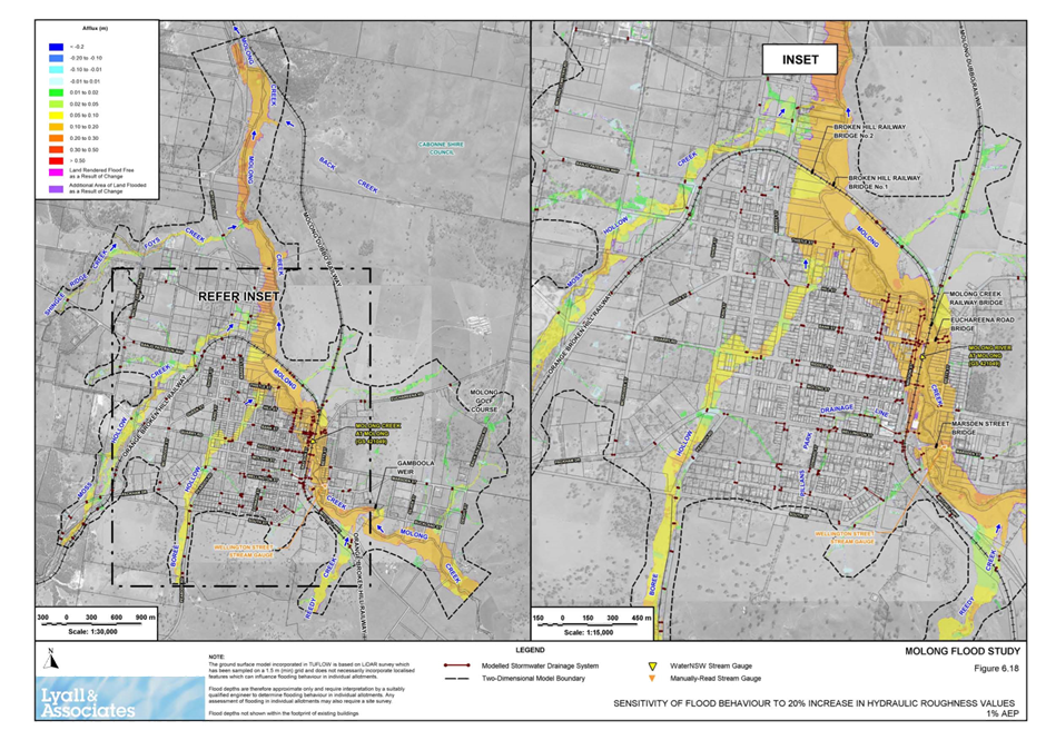
The Molong Flood Study seeks to define the extent of flooding experience by Molong for varying flood frequencies. An updated flood model has been produced through this process which takes advantage of new flood modelling techniques (2D modelling vs 1D modelling), and updated rainfall and runoff information (Australian Rainfall and Runoff guidelines 2019).
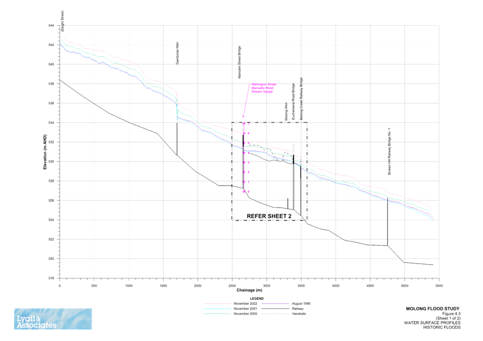
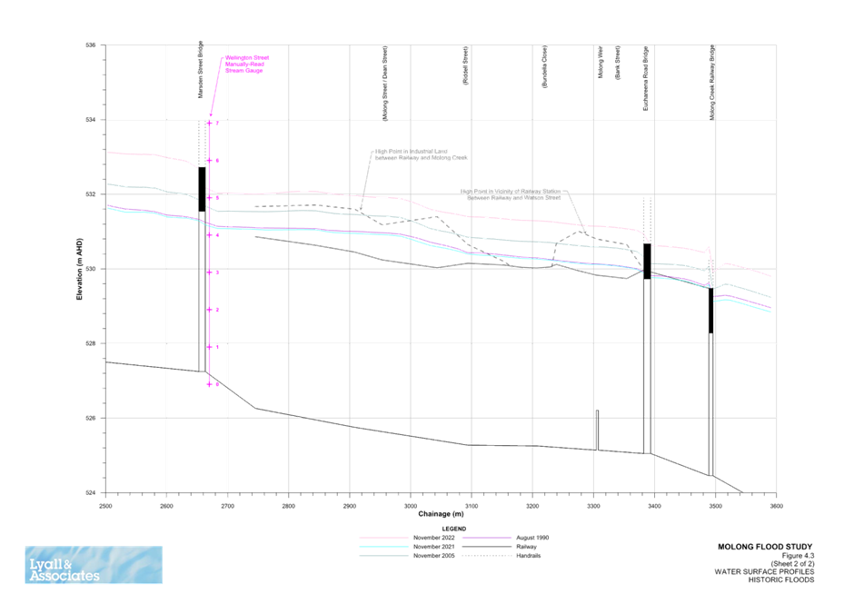
Further, the new flood study was developed through calibration with more recent flood events, being 26 November 2021 and 13-14 November 2022. This model was confirmed from feedback from a community questionnaire distributed to residents of Molong.
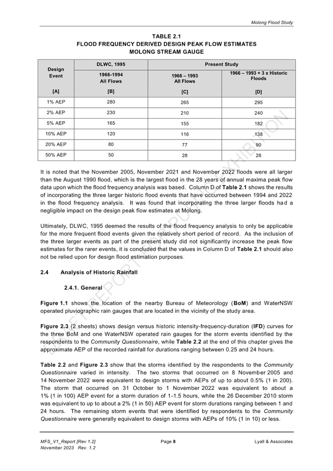
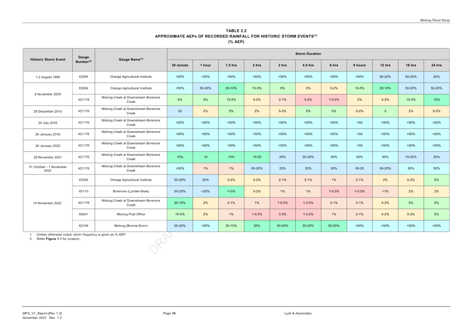
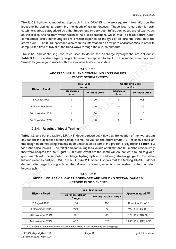
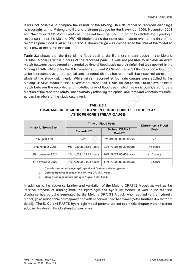
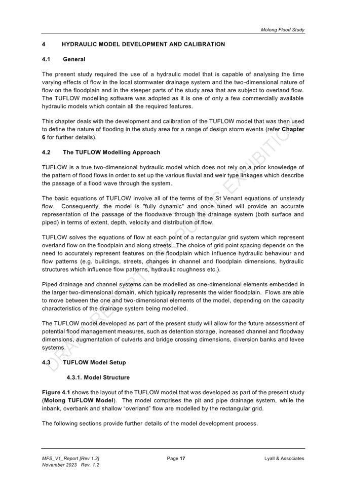
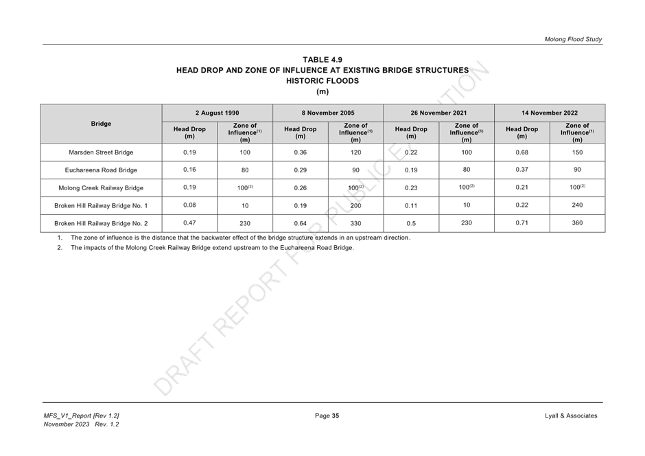
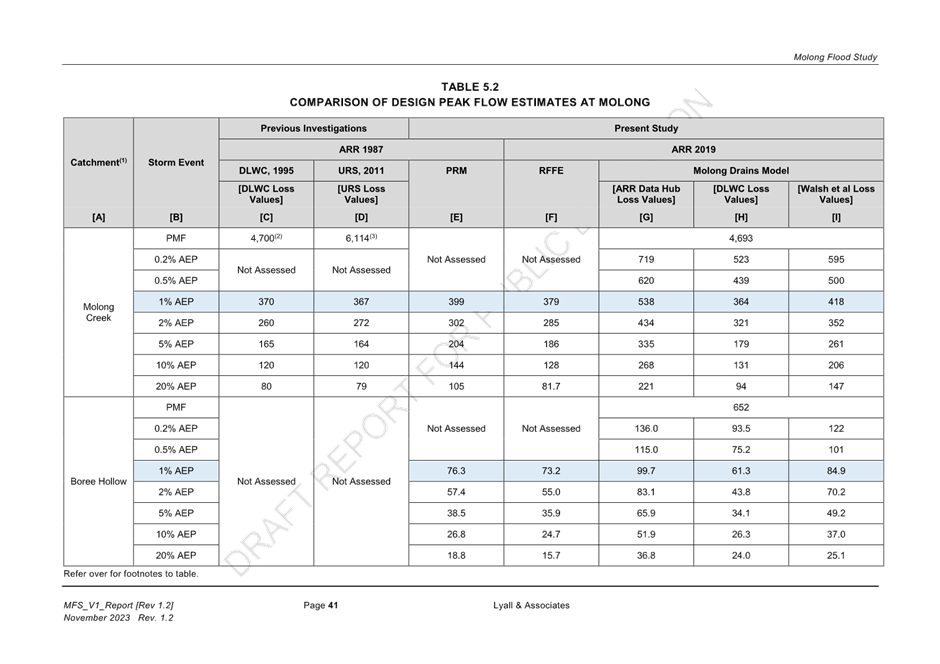
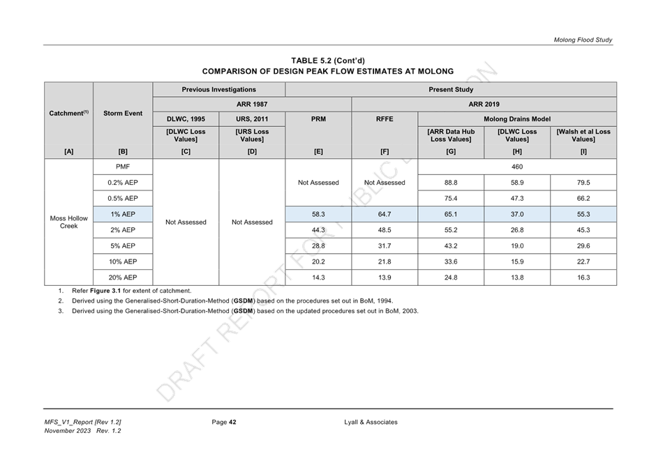
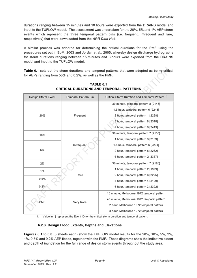
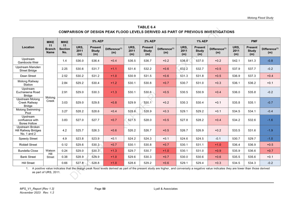
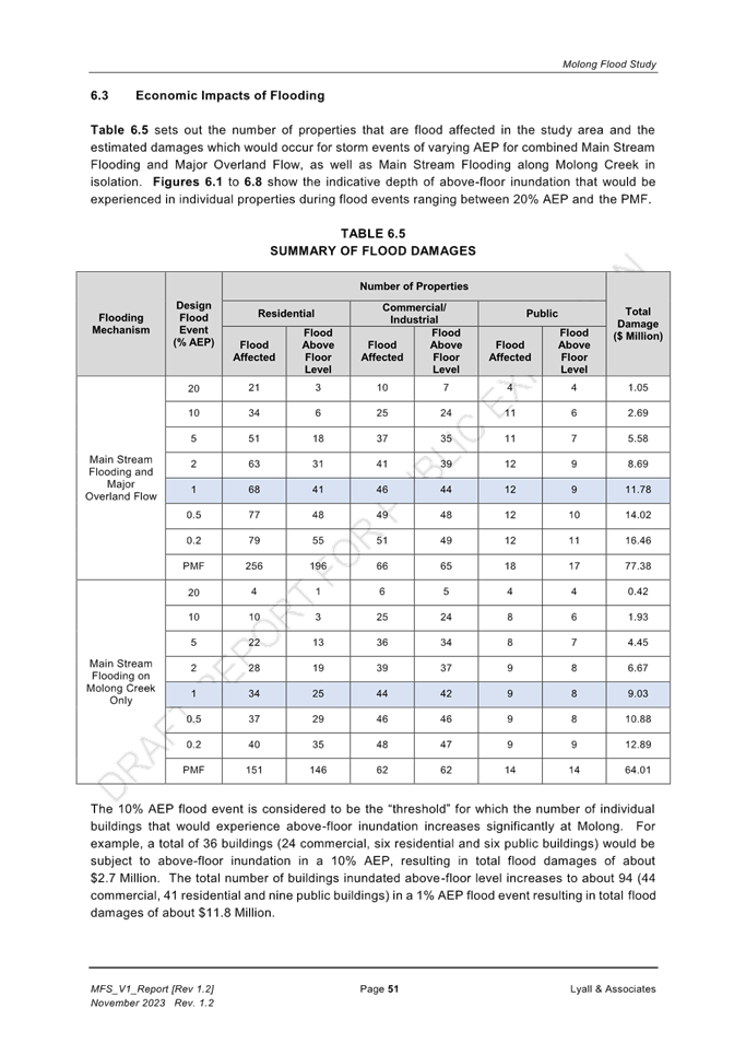
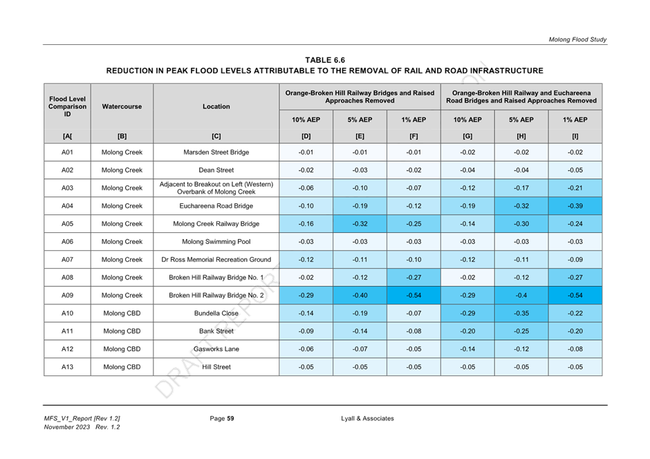
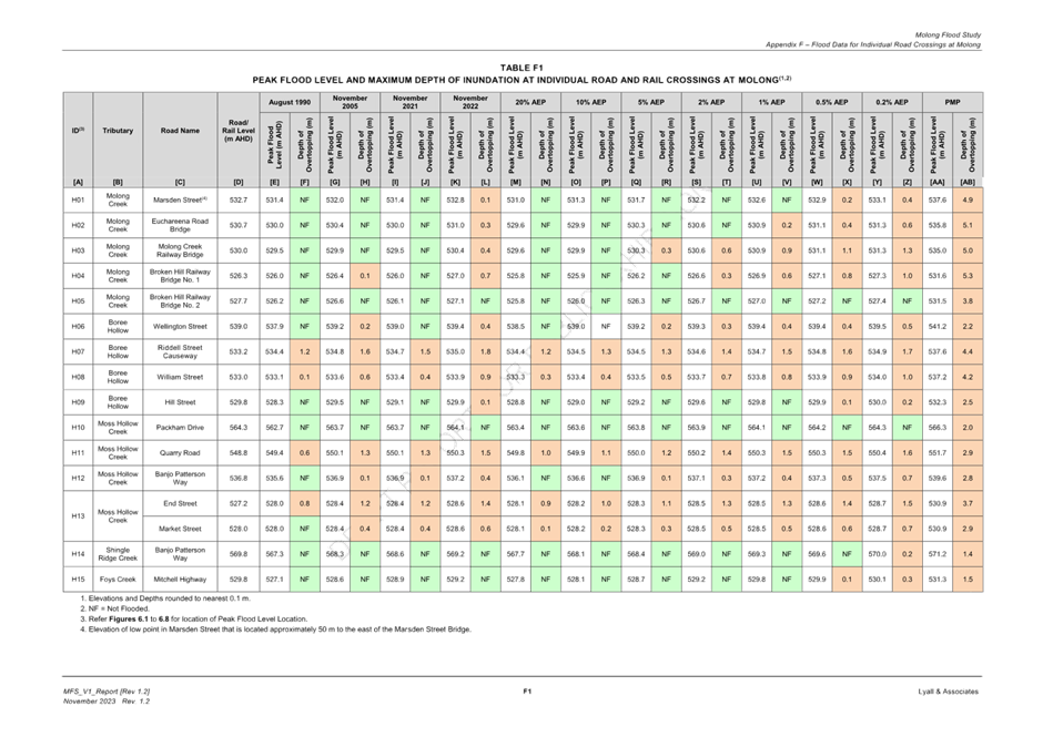
Utilising this analysis, approximate event probabilities have been associated to major historical flooding events in Molong, as the following table shows:
Key findings of the draft Molong Flood Study are:
1. Floodwater surcharges the bank of Molong Creek during floods as frequent as 20% AEP (1 in 5 ARI), but is contained to undeveloped areas.
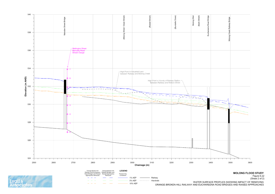
2. Floodwater overtops the Orange-Broken Hill Railway upstream of Molong at 10% AEP (1 in 10 ARI).
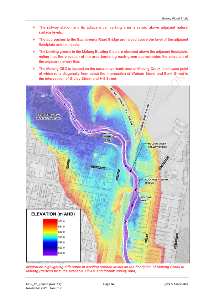
3. While the Euchareena Road and Orange-Broken Hill Railway crossings of Molong Creek increase peak flood levels a short distance upstream of their location, they are not the main cause of breakout of floodwater which impacts the Molong Central Business District.
4. The natural shape of the floodplain dictates that during major flood events, the western overbank of Molong Creek naturally functions as a conveyor of floodwater.
5. The majority of the floodplain in Molong is activated in a 5% AEP (1 in 20 ARI) event, due to the relative steep-sided nature of the floodplain in Molong.
6. Given the steepness of the floodplain, the Probable Maximum Flood level for Molong is approximately 5 metres higher than the 1% AEP (1 in 100 ARI) level.
7. Access to Molong SES Headquarters is cut when Hill Street becomes inundated during a 0.5% AEP (1 in 200 ARI).
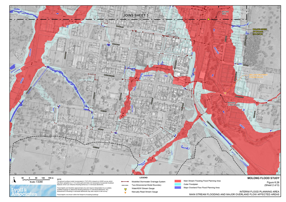
As it relates of overland flow in Molong:
1. The piped drainage elements beneath the road crossings of the major drainage line of Pillans Park have a capacity of less than 20% ARI (1 in 5 ARI).
2. Floodwater commences to surcharge the piped drainage system on this drainage line between Iceworks Lane and Watson Street in a 5% AEP (1 in 20 ARI).
3. With the exception of six locations in Molong, depths of inundation along roads attributable to major overland flow are generally less than 0.2m.
4. In the instance when intense rain fall directly over Molong, without elevated water levels in Molong Creek, ponding of major overland flow would occur to a maximum of 0.4-0.5 metres for design storms of 5% 1 in 20 ARI) AEP and 1% AEP (1 in 100 ARI) at the following locations:
a. Watson Street south of intersection with Bank Street;
b. Bank Street west of intersection with Watson Street;
c. Hill Street near intersection of Gidley Street.
Stormwater ponding in the road reserve at the above locations is shown to extend into adjacent commercial and residential development at reduced depths.
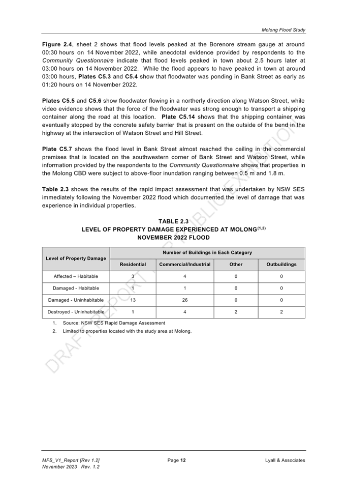
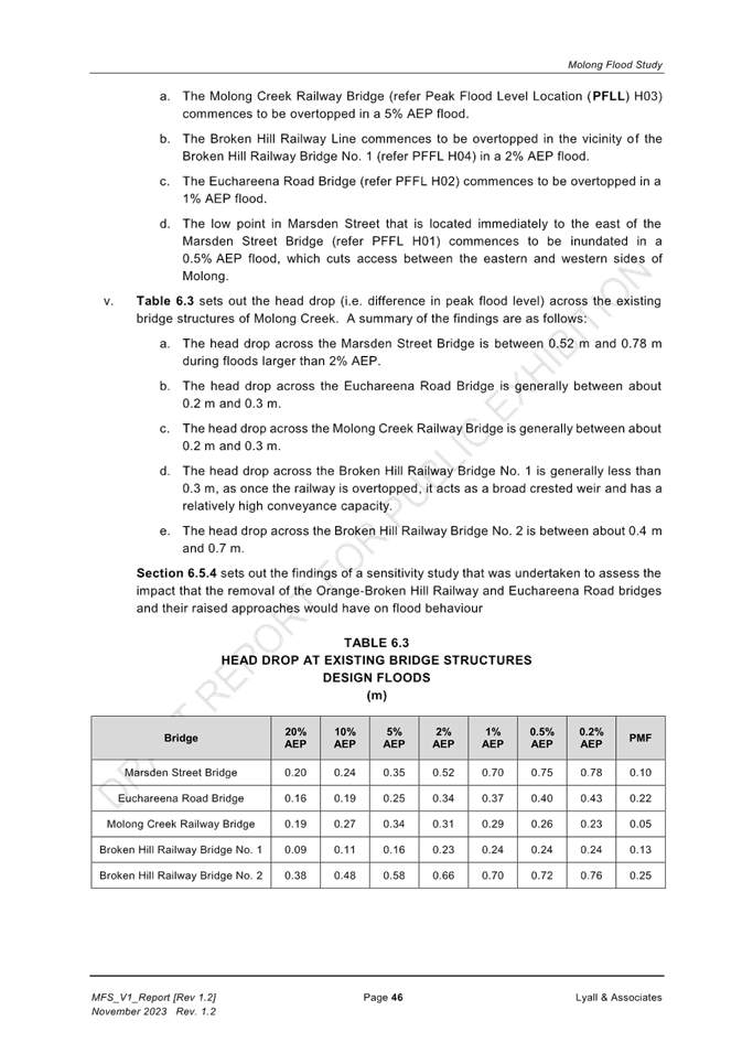
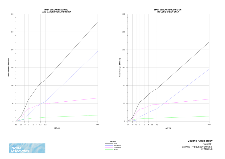
Economically, the “Present Worth Value” of tangible damages at Molong resulting from all floods up to 1% AEP (1 in 100 ARI) is approximately $12.0 Million. In the case of a 1% AEP event, the total number of buildings inundated above-floor level is 94 (44 commercial, 41 residential and 9 public buildings.
Next Steps
Exhibition is planned to open from mid-December 2023 and close mid-February 2024. This will allow for an exhibition period of 2 months to accommodate for the Christmas and New Year break.
A public information session has been tentatively booked for 1 February 2024, where the flood consultants will be available to meet with the community to go through the flood study and discuss the findings.
Following public exhibition, the flood study is scheduled to be presented to Council’s March Ordinary Meeting for adoption. It is proposed to return the flood study to the Floodplain Management Committee for consideration prior to presenting the final study for adoption.
ITEM 21 - DEVELOPMENT APPLICATION MODIFICATION 1999/0147/1 808 DAVYS PLAINS ROAD CUDAL - LIMESTONE MINE
REPORT IN BRIEF
|
Reason For Report |
For council's determination. |
|
Policy Implications |
Nil. |
|
Budget Implications |
Nil. |
|
IPR Linkage |
3.1.1.1a - Receive and assess Development Applications. |
|
Annexures |
1. Draft Conditions Development Application Modification 1999-0147-1⇩ |
|
File Number |
\Development Applications\DEVELOPMENT APPLICATION\1997 JULY -1999\03-1999-0147 - 1630909 |
|
THAT Modification to Development Application 1999/0147/1 for Lot 172 and Lot 278 DP 750139, being 808 Davys Plains Road, Cudal, be granted consent subject to the conditions attached.
|
Department Leader - Development Services' REPORT
|
ADVISORY NOTES Record of voting In accordance with s375A of the Local Government Act 1993, a division is required to be called when a motion for a planning decision is put at a meeting of council or a council committee. A division under s375A of the Act is required when determining this planning application.
Political Disclosures In accordance with s10.4 of the Environmental Planning and Assessment Act 1979, a person making a planning application to council is required to disclose political donations and gifts made within 2 years prior to the submission of the application and concluding when the application is determined.
In accordance with s10.4 of the Environmental Planning and Assessment Act 1979, a person making a public submission to Council in relation to a planning application made to council is required to disclose political donations and gifts made within 2 years prior to the submission being made and concluding when the application is determined.
Political donations and gifts (if any) to be disclosed include: · All reportable political donations made to any local councillor or council, · All gifts made to any local councillor or employee of the Council.
Nil planning application disclosures have been received.
Nil public submission disclosures have been received.
|
|
Application details |
|
|
Application No. and PAN 326195 |
DA 1999/0147/1 Modification [s4.55(1A)] |
|
Address |
Lot 172 and Lot 278 DP 750139 808 Davys Plains Road, Cudal |
|
Proposal |
Modification of Cudal Limestone Mine |
|
Date of Lodgement |
28/4/2023 |
|
Applicant |
Primelime (NSW) Pty Ltd Lodge by Premise 153 Peisley St Orange NSW 2800
|
|
Owner |
Mr Ian Shannon PO Box 54, Cudal NSW 2864 |
|
No. Submissions |
4 |
|
Value of Work |
N/A |
|
BASIX Certificate |
N/A |
|
Zone |
RU1 Primary Production |
|
Recommendation |
Approve with Modified Conditions |
Summary
The following report has been prepared by council’s contract town planner and provides an assessment of the modification application submitted for the amendment of the development consent to alter the layout of the operational domains and increase the annual extraction limit.
The proposal is considered a modification to the operational development consent DA1999/0147 in so far as it meets the requirements for s4.55 as substantially the same development. The proposal does not change the overall volume of material to be extracted.
The application was notified from 2 June 2023 until 16 June 2023.
The application has been referred to council for determination as it is an application to which there have been four public submissions by way of objection.
The change to the annual extraction rate will require an amendment to the Environment Protection Licence (EPL) and the application was also referred to the EPA. The EPA has confirmed that the EPL will need to be amended and raised no objection to the proposal.
As the development proposal is a modification to the original consent, only those conditions that are material to the proposed modification have been modified.
It is recommended that the application be approved subject to conditions of consent as modified.
PROPOSED DEVELOPMENT
Council's consent is sought for the modification of DA1999/0147 to amend the layout of the site and increase the annual production from 100,000 tonnes per annum to 150,000 tonnes per annum.
The development application was approved in 1999 and the development consent is operational. The site operates under the Mining Act 1996 and Mining Regulation 2016 and associated conditions. The site was required to maintain a Mine Operations Plan (MOP). During a site visit with Cabonne Council and Premise 13 September 2017, a DA modification was proposed to address inconsistences between the MOP and the development consent. The inconsistencies primarily related to the active mining in Pit 2 and proposed extent of Pit 3. This approach was reaffirmed by council in 2021.
Recent changes to the Mining Regulation 2016 have seen a change to the regulatory requirements including standard conditions for mining (Schedule 8A). This includes replacing the Mine Operation Plan (MOP) with a Rehabilitation Management Plan (RMP), Rehabilitation Objectives Statement and Forward Program overseen by the NSW Resources Regulator.
The change in the layout will be included in the rehabilitation documentation required by the Resources Regulator.
The changes proposed are:
· Manage and operate the site generally in accordance with the RMP;
· Update the mine layout to reflect the current and future operations;
· Increase the extraction limit from 100,000 tonnes per year to 150,000 tonnes per year.
The application was initially submitted as a 4.55(1A) modification being a modification with minor environmental impact. Following a review of the proposal, it was determined that, the application would need to address the impacts associated with the increase in annual production, the key impact being the potential resulting increase in traffic [potentially making it a s4.55(2) modification].
An additional information request was made to the applicant to prepare a Traffic Impact Assessment (TIA) and update the SEE to support the application. The request for information also raised the matter of the type of modification. This information was received 29 September 2023. Following consideration of the TIA and having regard to the revised SEE, Council is satisfied that the application can be considered as substantially the same development and that the proposed impacts have been adequately addressed by the applicant and hence it is a s4.55(1A) modification.
The quarry operates under an Environmental Protection Licence (EPL) and the increase in the yearly extraction (maximum) will require a modification to the EPL to address the change in the annual extraction limit. The applicant has advised that the EPA has confirmed that the licence will need to be amended should the modification be approved by council.
In determining the modification, the consent authority must take into consideration such of the matters referred to in section 4.15(1) as are of relevance to the development the subject of the application.
Mine layout
Mine operation and disturbance areas need to be identified and the MOP (now the RMP) and be consistent with the development consent. Some variations had occurred to haulage roads, pit extents and processing and stockpile areas have occurred over time. Primelime have generally operated in the disturbance footprint and are now seeking to regularise the mining operation to reflect the current site layout, incorporating changes to the pit extents.
Comparisons between the EIS and current arrangement are illustrated in the Statement of Environmental Effects (SEE), shown in Figure 1 below.
Traffic
A TIA has been prepared by Premise and addresses the proposed impact of the proposal on traffic. The Site Access Road is a bitumen sealed, two lane, two way local road with two 3.5m wide lanes in each direction (road upgrade was completed as a condition of development consent). There are gravel shoulders approximately 1m wide along both sides of the road. The road narrows to a total width of 6m, comprising a centre seal width of 4m with 1m gravel shoulders on each side, at approximately 120m south of the Davy’s Plains Road / Site Access Road intersection.
The applicant has based the traffic assessment on an anticipated average extraction level of 60,000 tonnes per year and up to a maximum of 150,000 tonnes per year. The modification will result in the following traffic generation:
• An average AADT of 32 vehicles per day made up of 20 heavy vehicles and 12 light vehicle movements per day. This is based on an average of 10 heavy vehicles loads per day and 6 staff in 6 cars arriving and leaving each day; and
• A peak hour traffic of 20 vehicles per hour made up of 12 heavy vehicles and 8 light vehicle movements per hour. This is based on a maximum of 6 trucks being loaded in an hour and assuming this occurs within the same hour of a peak of 8 staff arriving/leaving.
The application was referred to council’s engineer and comments have been provided in relation to traffic and access.
Figure 1: Comparison between EIS and Current Pit Layout
Source: SEE, Premise, 2023.
SITE
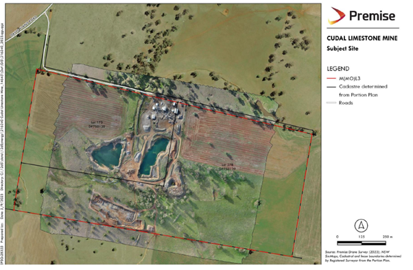
The property is Lot 172 and Lot 278 DP 750139 Davy’s Plains Road, Cudal. The site is located off Davy’s Plains Road, approximately 4.5 km south from Cudal. Access to the site is via an unnamed public road from Davys Plains Road. The access road is a bitumen sealed road that terminates at the entry to the mine site. Despite the road terminating at the mine site, an unformed road corridor continues to the east.
The Cudal Limestone Mine began in 1987 under a Private Mining Agreement (PMA) on the property “Davys Plains”. Amendments to the Mining Act 1992 in 2010 ended PMAs and a Mineral Owner Mining Lease Application was granted over the site in 2011, M(MO)LA 12. M(MO)LA 12 was transferred to Primelime in May 2016, now M(MO)L 3 which expires in 2037.
Figure 2: Subject Site
Source: Premise, Traffic Impact Assessment, 2023.
Figure 3: Development Site
Source: SEE, Premise, 2023.
STATUTORY ASSESSMENT
4.55(1A) Modifications involving minimal environmental impact
A consent authority may, on application being made by the applicant or any other person entitled to act on a consent granted by the consent authority and subject to and in accordance with the regulations, modify the consent if:
(a) it is satisfied that the proposed modification is of minimal environmental impact, and
(b) it is satisfied that the development to which the consent as modified relates is substantially the same development as the development for which the consent was originally granted and before that consent as originally granted was modified (if at all), and
(c) it has notified the application in accordance with: (i) the regulations, if the regulations so require, or (ii) a development control plan, if the consent authority is a council that has made a development control plan that requires the notification or advertising of applications for modification of a development consent, and
(d) it has considered any submissions made concerning the proposed modification within any period prescribed by the regulations or provided by the development control plan, as the case may be. Subsections (1), and (2) do not apply to such a modification.
In regards subclause ‘a’, it is considered that the modification(s) sought as part of this application is of minimal environmental impact. There is an increase in traffic associated with the additional production on an annual basis but the assumption as to the resources as identified in the EIS has not been altered by the modification. The impact associated with traffic has been considered by council’s engineer (refer below).
The overall net change to the area of disturbance is minimal. There are no significant changes to either the hours of operation or processing methods.
In regards subclause ‘b’, the development to which the consent as modified relates is substantially the same development as the development for which consent was originally granted. Development consent was granted in 1999 for the Expansion of limestone quarry and milling operations to permit an output of 100,000 tonnes of limestone products per annum.
The initial assessment considered the principles and tests established by the Land and Environment Court to determine if a proposed modification is “substantially the same”. Having regard to these principles, it was considered that the proposal is substantially the same as that which was originally approved.
The modification will not change the use of the site or the manner in which material is extracted. The matter of changes to the active domains and extent of the disturbed areas are dealt with through the Mining Act and associated conditions including the requirement for the preparation of a Rehabilitation Management Plan (RMP), Forward Program and Rehabilitation Objectives Statement. All of these requirements are administered by the NSW Resources Regulator and replace the former regulatory requirements for a Mine Operations Plan (MOP). Regulatory changes are not material to the development as approved.
In regards to subclause ‘c’, the application was notified to adjoining owners for 14 days from 2 June – 14 June 2023. Council received four submissions by way of objection. The issues raised and a response are considered later in this report.
SECTION 4.15 CONSIDERATIONS – EP&A Act, 1979
Section 4.55(3) of the EPA Act states that:
In determining an application for modification of a consent under this section, the consent authority must take into consideration such of the matters referred to in section 4.15(1) as are of relevance to the development the subject of the application. The consent authority must also take into consideration the reasons given by the consent authority for the grant of the consent that is sought to be modified.
The relevant provisions of applicable Environmental Planning Instruments (EPIs), Development Control Plans (DCPs), and matters prescribed by the Regulation in accordance with Section 4.15 of the EPA Act have been considered below.
4.15(1)(a) the provisions of:
(i) any environmental planning instruments
The proposed modification does not interfere with the operation of any SEPPs.
Cabonne Environmental Plan 2012
The principle environmental planning instrument is the Cabonne Local Environmental Plan 2012 (CLEP). The proposal has been considered in the context of the CLEP.
The specific provisions of the CLEP are addressed below.
Aims of the CLEP2012 (clause 1.2)
The proposed development is consistent with the broad aims of the CLEP2012.
Permissibility
The land is zoned RU1 Primary Production. The zone permits the approved use. As the proposal is a modification for substantially the same development, further consideration of the permissibility under the zone is not required.
The relevant provisions of the CLEP are addressed in the table below.
|
Provision |
Comment |
|
Part 4 Principal development standards |
|
|
Clause 4.1 -4.6 |
Not applicable to the proposal |
|
Part 5 Miscellaneous provisions |
|
|
Clause 5.1-5.22 |
Not applicable to the proposal |
|
Part 6 Additional local provisions |
|
|
Clause 6.1 (repealed), 6.2 -6.9 |
Not applicable to the proposal |
Section 4.15(1)(a)(ii) the provisions of any proposed instrument
There are no draft instruments applicable.
Section 4.15(1)(a)(iii) provisions of any development control plan
There are no Development Control Plans applicable to the development.
Section 4.15(1)(a)(iiia) provisions of any planning agreement that has been entered into under section 7.4, or any draft planning agreement that a developer has offered to enter into under section 7.4
Not Applicable
Section 4.15(1)(a)(iv) the regulations (to the extent that they prescribe matters for the purposes of this paragraph)
The Environmental Planning and Assessment Regulation 2021 provides no specific requirements. The process for the assessment and determination of the application are consistent with the Regulation. Appropriate conditions of consent are included within the existing consent to ensure compliance with any relevant regulations.
Section 4.15(1)(b) the likely impacts of the development, including environmental impacts on both the natural and built environments, and social and economic impacts in the locality
The modification is minor, defined as a modification with minimal impact. The SEE has addressed the nature of the impacts (summaries below). The TIA considers the potential impact of an increase in AADT.
Access and traffic – The TIA considers the impact of additional traffic to be minor and concludes:
· The site is expected to generate an average of 32 vehicles movements per day made up of 20 heavy vehicles and 12 light vehicle movements per day.
· The site is expected to generate a peak 20 vehicles per hour made up of 12 heavy vehicles and 8 light vehicle movements per hour.
· The surrounding road network can accommodate the traffic generated by the site, and
· The intersection of the access road with Davys Plains Road has adequate site distance and will continue to operate at a Level of Service A, with minimal delays.
The following mitigation measure are currently employed and not proposed to be altered by the modification:
· Truckloads of material transported off-site are covered and recorded at the weighbridge on entry and exit.
· Posted internal speed limits are adhered to, to ensure safety and minimise dust and noise impacts.
· The internal roads are maintained to a safe standard with a water cart used to minimise dust generation when required.
· All drivers shall comply with the Driver’s Code of Conduct.
In addition, the council engineer provided the following comment:
From the data provided, it is unclear what the anticipated Maximum Daily Truck Movements would be at the ceiling of 150,000 tonnes per year production. Council is concerned with the concentration of traffic generated from the quarry during peak production times, even though the overall tonnage to be extracted from the quarry during its lifetime will not change.
It is noted that the original consent for DA 1999/0147 required that a BAR/BAL be constructed at the intersection of the quarry access road and Davys Plains Road, which does not appear to have been constructed. An observation of the site revealed that trucks are currently tracking off the edge of the pavement onto the gravel shoulder when turning into the private road to the quarry. The anticipated traffic distribution for the consent modification assumes 80% of quarried product will head north along Davys Plains Road, with the remainder heading south.
Taking into account the above factors and the increased traffic on the section of Davys Plains Road north of the private access road, it is recommended that at a minimum the construction of a BAL be a condition of consent for the modification.
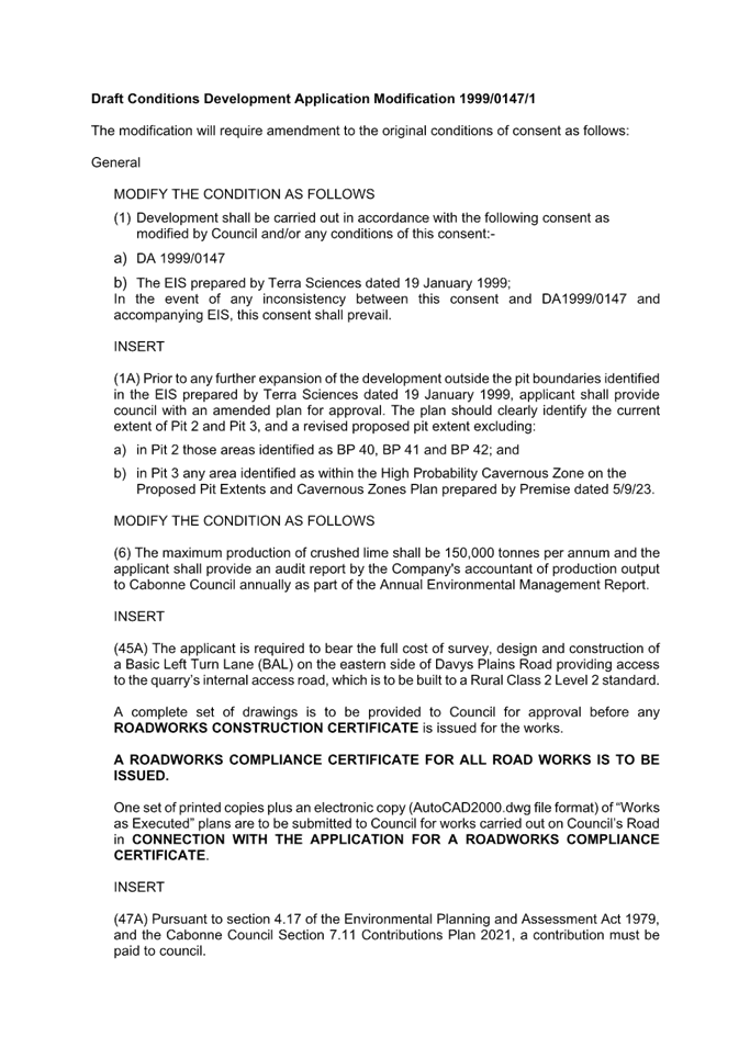
The applicant, in Appendix D of the SEE provided comments in relation to the existing conditions of consent, including the removal of condition 45 relating to the upgrade of the access road. The following condition has been recommended by council’s Engineer:
ROAD DESIGN AND CONSTRUCTION (Left Turn Lane)
The applicant is required to bear the full cost of survey, design and construction of a Basic Left Turn Lane (BAL) on the eastern side of Davys Plains Road providing access to the quarry’s internal access road, which is to be built to a Rural Class 2 Level 2 standard.
A complete set of drawings is to be provided to Council for approval before any ROADWORKS CONSTRUCTION CERTIFICATE is issued for the works.
A ROADWORKS COMPLIANCE CERTIFICATE FOR ALL ROAD WORKS IS TO BE ISSUED.
One set of printed copies plus an electronic copy (AutoCAD2000.dwg file format) of “Works as Executed” plans are to be submitted to Council for works carried out on Council’s Road in CONNECTION WITH THE APPLICATION FOR A ROADWORKS COMPLIANCE CERTIFICATE.
Geology – The 1999 EIS excluded mining in certain areas until such time as additional assessment had been completed into the potential for significant karst features. Condition 44 Caves/Karst Systems states:
44) No disturbance or quarrying activities shall occur about or near the caves/Karst systems as identified in the EIS. The area shall be appropriately sign posted and marked to the satisfaction of Cabonne Council.
A site visit was undertaken by Geologist Ian Cooper (BSc(Hons), BE(Mining), MSc, MAusIMM, MSME) in June 2016 in the immediate mine area and areas intended for future mining. Cooper provided a written report titled “Notes on Karst Potential of the Cudal Limestone Quarry”. These observations do not amount to an assessment to the extent that Council could be satisfied that the extension of Pit 2 and Pit 3 to areas and is not an assessment. Further, the information provided does not include any assessment of sites BP40, and BP42 adjacent to Pit 2 or BP 55 and BP 56 within the proposed extension area of Pit 3.
Cooper noted several factors that mitigate against the development of significant karst features about the mine area, including:
· No major collapse dolines are present.
· No apparent disruption to conventional surface drainage. No evidence was observed of surface water flows being diverted underground.
· The impounded nature of the limestone. The limestone is entirely surrounded by non - limestone rocks that provide a flood of sediment through the area.
· The exposed limestone within the existing quarries is quite solid with only limited solutional development.
Cooper concluded:
Examination of limestone about the Cudal Limestone Quarry shows that some cave development is present. This development was solely observed to be due to vadose dissolution above the water table with some preferential development along the intersection lineation of westerly dipping bedding and subvertical jointing.
Only minor development is present by direct observation and the lack of topographic features associated with major cave development.
The SEE states that the previous leaseholder undertook extraction from an area identified as a high probability cavernous zone in Pit 2.
Further, the proposed expansion of Pit 3 would intersect an area identified in the 1999 EIS as a high probability cavernous zone, including two mapped cave sites known as BP55 and BP56 which are located at the northern edge of the existing approved Pit 3 location.
The SEE goes on the state that Prior to commencing extraction, a final design for the expanded Pit 3 would be prepared within the proposed pit extent. The final design would be informed by an assessment of the expansion area by a suitably qualified person to verify the presence and assess the condition of mapped cave sites BP55 and BP56, and any need to avoid impact to those sites, if they are still present.
The information provided does not provide an adequate assessment of the impact or justification as to the suitability of these areas for mining and is not supported. A further application will be required that includes an assessment of the impact of mining on the known cavernous sites and should be accompanied by a detailed final design as proposed by the applicant.
Figure 4: Proposed Pit Extents and Cavernous Zones
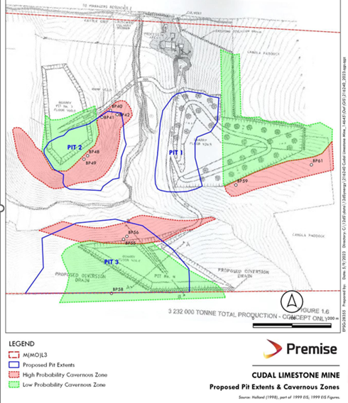
Source: SEE, Premise, 2023.
Noise and Vibration – The proposal is unlikely to result in an increase in noise and vibration beyond that which has been addressed in the EIS.
Ait Quality – The proposal is unlikely to result in an increase in air quality beyond that which has been addressed in the EIS. There are existing conditions relating to dust and it is also regulated in the EPL.
Surface water – The minor change in the active domains and disturbance area will result in the need to ensure that appropriate sail and water management practices are maintained.
The consent requires the preparation of an Erosion and Sediment Control Plan and Stormwater Management Scheme (conditions 12 and 13). The application acknowledges that these documents have not been prepared and as they related to construction phase, may no longer be applicable. The applicant suggests removing these conditions. It is not appropriate to modify a consent to remove conditions for the simple fact they have been satisfied or become redundant. Further, Council will not amend conditions included under a General Terms of Approval from a referral agency.
Groundwater – The modification does not interfere with the proposed pit depths greater than anticipated in the 1999 EIS. The depth of pits is associated with the karst landform and associated hydrology. As noted above, a further detailed assessment will be required to inform the Pit 3 design which should include the relationship between hydrology and the high probability cavernous zones.
Flora and fauna impacts – The proposed development will not require the clearing on significant vegetation. No concerns are raised.
As noted previously, the environmental impacts of the proposal were addressed in the original EIS and conditions of consent, including General Terms of Approval provided by referral and concurrence agencies.
Section 4.15(1)(c) the suitability of the site for the development
Site satiability was determined in the original application and approval, and generally excluded any extraction for areas within the site identified as high probability cavernous zones. The modification of the pit extent as now proposed may impact these areas. The application includes a record of a site visit in 2016 by geologist, Ian Cooper, however, this does not sufficiently address the impact of the development on these areas.
The application should be required to satisfy condition 44 relating to caves/karst systems until further assessment could be undertaken and considered by council.
Section 4.15(1)(d) Any submission made in accordance with this Act or the Regulations
The development application was notified for 14 days. Four submissions were received. These have been considered in the following table.
|
Issue |
Response |
|
Increase in truck movements
|
The original application sought to relay on the original EIS traffic assumption (1999). Following an initial assessment, council requested that the application prepare a new TIA. The TIA has been considered by council’s Engineers to satisfactorily address the impact of the change to extraction limits. The road network can accommodate the additional traffic. The proposal has been considered by council engineering staff and an amendment to the conditions is proposed that include an upgrade of the access intersection. |
|
Outdated water and noise studies Increase in noise and dust as a result of increase in production 50%
|
No additional machinery, blasting or extended hours of operation are proposed. The EIS establishes a background noise level and acceptable noise emissions at residences and the methodology applied remains unchanged. Condition 11 requires that an Environmental Management Plan be prepared and includes: · Management measures for noise, traffic, air quality, water, visual amenity, flora and fauna and heritage, erosion and sediment. · Environmental monitoring in relation to noise, traffic, air quality, ground water and surface water, flora and fauna. The supporting documentation states that Primelime will continue to undertake noise and vibration monitoring. The EPL includes mandatory reporting of complaints associated with the site, including noise and dust. |
|
Increase in production will increase blasting, crushing, water use drilling |
The applicant has stated that there will be no change to the “method, intensity or frequency” of blasting as outlined in the 1999 EIS. |
|
Original DA/EIS should be updated |
The quarry has been approved and is operational. The approval relates to an upper annual production limit of 100,000 tonnes per year. The original EIS was assessed at the time of determination. There is no opportunity for council to require a complete update and reassessment of the project under this modification. |
|
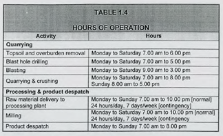
Operating hours outside ordinary work hours. Request hours be 7am-8pm with no blasting, drilling and rock hammering on the weekends.
|
The hours of operation are included in the original EIS and referenced in condition 26 of the consent. It is noted that the blasting hours in the EPL 9am – 5pm are different from those in the EIS 9am-3pm Mon-Sat. The modification requests that the condition be amended to reflect the EPL. The EPL cannot impose conditions that are inconsistent with the development consent. There has been no justification in the Modification to support the extension of hours of operation for blasting. The hours in the development consent should prevail. The hours of operation include a reference to “normal” and “contingency” relating to processing and product dispatch. The original EIS does not provide an explanation as to the circumstances in which the site would operate under condition of “contingency”. However, it is not within the scope of the modification that council reconsider the general hours of operation.
It is noted that under the EPL, the operator is required to record, address and report on any complaints received. |
|
Increase in blasting |
The SEE provides confirmation that there is no change: · in operating hours · to the methods of extraction or processing from the 1999 EIS · to the methods or intensity or frequency of blasting outlined in the 1999 EIS. The EPL requires that the operator record all complaints in relation to pollution; noise, dust, water. |
|
Impact on water quality
|
There are no changes to the management of water or conditions associated with water and drainage proposed under the modification. Groundwater monitoring is required under condition 16 of the consent via an Environmental Management Plan. |
|
Dust emissions are significant. Blast noise is obvious from adjoining property. |
As noted above, the EPL provides a mechanism for complaints in relation to excessive dust and noise. The EIS addressed noise and noise is addressed in condition 25 of the consent to the extent that the mine must: · exceed LA10(15 minute) noise emission limit of 40dB(A) during the day (7am-10pm) at any affected residence or noise sensitive location. · Not exceed LA10(15 minute) noise emission limit of 35dB(A) during the night (10pm-7am) within 1 metre of any affected residence. Conditions 30-31 address blasting. |
Section 4.15(1)(e) The public interest
The proposed development is consistent with the planning framework and not contrary to the public interest.
REFERRALS
The application was referred internally to Engineering and is provided as follows:
Referring to the Traffic Generation section of the TIA, the weighbridge Average Daily Truck Movements over the last two years (17 -19 Average Daily Truck Movements) correspond generally with the forecast average production figure of 60,000 tonnes per year stated in the original DA (18 Average Truck Movements per day). The Maximum Daily Truck Movements of 104 – 112 indicate the level of concentration of trucks at peak times.
The applicant anticipates that with revised operational procedures, the modified traffic generation as a result of the DA modification would yield 20 Average Daily Truck Movements and 12 Average Light Vehicle Movements per day, with a forecast production of between 60,000 tonnes and 150,000 tonnes per year. An expected peak hour traffic volume of 12 Heavy Vehicle Movements and 8 Light Vehicle Movements per hour has been given.
From the data provided, it is unclear what the anticipated Maximum Daily Truck Movements would be at the ceiling of 150,000 tonnes per year production. Council is concerned with the concentration of traffic generated from the quarry during peak production times, even though the overall tonnage to be extracted from the quarry during its lifetime will not change.
It is noted that the original consent for DA 1999/0147 required that a BAR/BAL be constructed at the intersection of the quarry access road and Davys Plains Road, which does not appear to have been constructed. An observation of the site revealed that trucks are currently tracking off the edge of the pavement onto the gravel shoulder when turning into the private road to the quarry. The anticipated traffic distribution for the consent modification assumes 80% of quarried product will head north along Davys Plains Road, with the remainder heading south.
Taking into account the above factors and the increased traffic on the section of Davys Plains Road north of the private access road, it is recommended that at a minimum the construction of a BAL be a condition of consent for the modification.
As there is a direct nexus between the quarry operations utilising heavy haulage and the need for increased maintenance of Council’s infrastructure, Section 7.11 Contributions are payable for this modification application.
There is currently a condition (47) of consent that requires an annual maintenance payment of $1,350 per year based on a 5km at $90/year indexed to CPI. Indexed, this would amount to $170.31 per km or $2,554.65 per year payable in 2023/24 dollars.
The Cabonne Council Section 7.11 Contributions Plan 2022 – Heavy Vehicles was adopted and commenced 17 October 2022. An amendment to the development enables council to consider the application of the new Contributions Plan to the extent that it applies to that aspect of the proposal being modified. The modification application does result in the reconsideration of impact under 4.15, including the impact of the additional traffic on the local road network.
In this instance, it has been applied to the additional concentration of traffic in any 12 month period. Therefore, the Section 7.11 Contribution Plan has been applied to the production over 100,000 tonnes up to 150,000 tonnes based on 15 km of local roads consistent with the original haulage route assumptions in the 1999 EIS.
The contribution would be calculated annually based on the actual volume of material leaving the site. For example, if the annual production was 110,000 tonnes, 10,000 tonnes would be subject to the contribution. The calculation, based on 50,000 tonnes, under the contribution plan is as follows:
$0.17 per tonne per km = 0.17 x maximum tonnage x length of roads travelled
= 0.17 x 50,000 x 15km
= $127,500 per annum
If production did not exceed 100,000 tonnes, no additional contribution is required.
Amended Conditions
The modification will require amendment to the conditions of consent as follows:
General
MODIFY CONDITION 1 TO READ AS FOLLOWS (altered wording shown in italics)
(1) Development shall be carried out in accordance with the following consent as modified by Council and/or any conditions of this consent:-
a) DA 1999/0147
b) The EIS prepared by Terra Sciences dated 19 January 1999;
In the event of any inconsistency between this consent and DA1999/0147 and accompanying EIS, this consent shall prevail.
INSERT AN ADDITIONAL CONDITION TO READ AS FOLLOWS:
(1A) Prior to any further expansion of the development outside the pit boundaries identified in the EIS prepared by Terra Sciences dated 19 January 1999, applicant shall provide council with an amended plan for approval. The plan should clearly identify the current extent of Pit 2 and Pit 3, and a revised proposed pit extent excluding:
a) in Pit 2 those areas identified as BP 40, BP 41 and BP 42; and
b) in Pit 3 any area identified as within the High Probability Cavernous Zone on the Proposed Pit Extents and Cavernous Zones Plan prepared by Premise dated 5/9/23.
MODIFY THE EXISTING CONDITION 6 TO READ AS FOLLOWS:
The maximum production of crushed lime shall be 150,000 tonnes per annum and the applicant shall provide an audit report by the Company's accountant of production output to Cabonne Council annually as part of the Annual Environmental Management Report.
INSERT AN ADDITIONAL CONDITION TO READ AS FOLLOWS:
(45A) The applicant is required to bear the full cost of survey, design and construction of a Basic Left Turn Lane (BAL) on the eastern side of Davys Plains Road providing access to the quarry’s internal access road, which is to be built to a Rural Class 2 Level 2 standard.
A complete set of drawings is to be provided to Council for approval before any ROADWORKS CONSTRUCTION CERTIFICATE is issued for the works.
A ROADWORKS COMPLIANCE CERTIFICATE FOR ALL ROAD WORKS IS TO BE ISSUED.
One set of printed copies plus an electronic copy (AutoCAD2000.dwg file format) of “Works as Executed” plans are to be submitted to Council for works carried out on Council’s Road in CONNECTION WITH THE APPLICATION FOR A ROADWORKS COMPLIANCE CERTIFICATE.
INSERT AN ADDITIONAL CONDTION TO READ AS FOLLOWS:
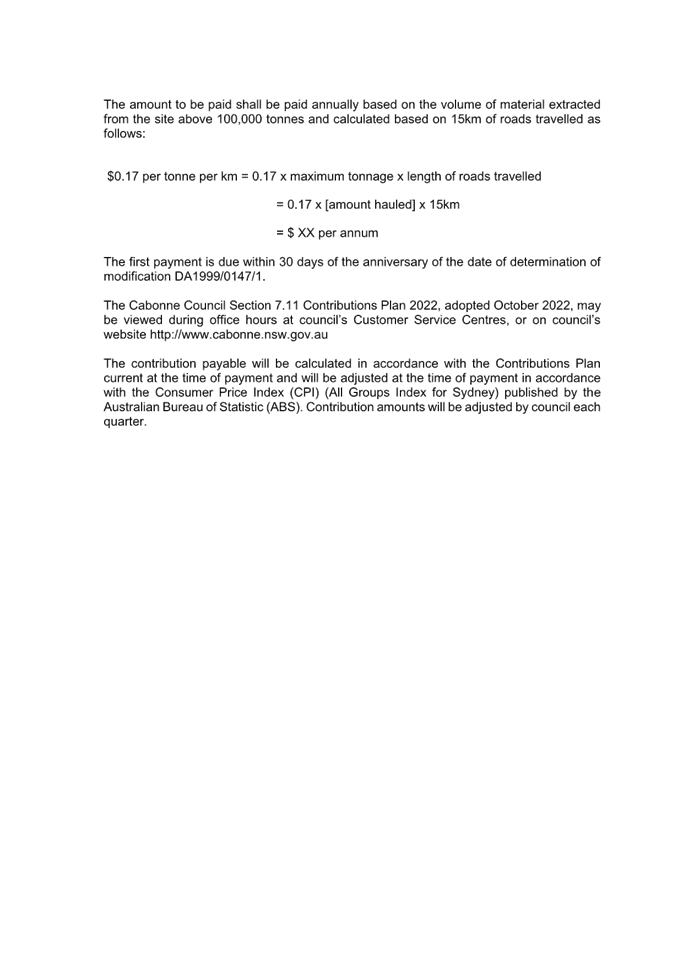
(47A) Pursuant to section 4.17 of the Environmental Planning and Assessment Act 1979, and the Cabonne Council Section 7.11 Contributions Plan 2021, a contribution must be paid to council.
The amount to be paid shall be paid annually based on the volume of material extracted from the site above 100,000 tonnes and calculated based on 15km of roads travelled as follows:
$0.17 per tonne per km = 0.17 x maximum tonnage x length of roads travelled
= 0.17 x [amount hauled] x 15km
= $ XX per annum
The first payment is due within 30 days of the anniversary of the date of determination of modification DA1999/0147/1.
The Cabonne Council Section 7.11 Contributions Plan 2022, adopted October 2022, may be viewed during office hours at council’s Customer Service Centres, or on council’s website http://www.cabonne.nsw.gov.au
The contribution payable will be calculated in accordance with the Contributions Plan current at the time of payment and will be adjusted at the time of payment in accordance with the Consumer Price Index (CPI) (All Groups Index for Sydney) published by the Australian Bureau of Statistic (ABS). Contribution amounts will be adjusted by council each quarter.
Other conditions
The application, in Appendix D to the SEE includes comments on the current conditions of consent, including the proposed removal of certain conditions.
In Ku-ring-gai Council v Buyozo Pty Limited [2021] NSWCA 177, (Buyozo) the Court of Appeal determine that there is no power to modify a development consent to amend a condition of consent alone. The modification has to be to the development itself and conditions modified to address that change to the development.
Having regard to Buyozo, the request to amend conditions cannot be considered as they do not “modify the development”.
When determining a modification application, the consent authority can impose new conditions as well as amending existing conditions, however the discretion to do so is defined by the matters raised for consideration in the application.
Any new conditions or changes to existing conditions must relate to the specific subject-matter and nature of the modification(s) sought.
The modification relates to the ongoing operation of the site in accordance with the Rehabilitation Management Plan, increase in the yearly production from 100,000 tonnes to 150,000 tonnes and update the mine layout to reflect existing and future operations.
Not all of the proposed changes to the conditions in Appendix D relate the planning matters that are the subject of the application. Contemporaneous conditions will not be removed or amended to reflect 2023 legislative requirements or change to the name of Government Departments. Conditions proposed by other regulatory agencies under General Terms of Approval or referral have also been retained. The various statutory and regulatory amendments and associated transitional arrangements account for this. Further, removing conditions that may have been satisfied alters the context of the approval.
It is noted that the modification relates to the continued operation of the site in accordance with the Rehabilitation Management Plan (RMP). This is a different document from an Environmental Management Plan as required under condition 11 which should be retained. The RMP is required by the Stannard conditions for mining leases (condition 10) under the Mining Regulation, 2016 (Schedule 8A).
The application states that hours of operations of the EPL and consent, as they relate to blasting, are different. The EPL is required to be consistent with the development consent in this regard and the application has provided no evidence to support a change to the blasting hours.
Finally, there are a number of conditions of development consent that appear not to have been satisfied. It may be appropriate that council request that the operator demonstrate that the conditions of consent have been or continue to be satisfied.
SUMMARY
The application has been assessed having regard to Section 4.15 and 4.55(1A) of the Environmental Planning and Assessment Act 1979 to the extent that they relate to the conditions of consent proposed to be modified.
The application was notified and a number of objections were raised by adjoining land owners. These matters relate primarily to the adequacy of the 1999 EIS and included concerns about traffic, noise, dust and hours of operation. The application was supported by a Traffic Assessment that considered the impact of the amendment to the yearly production. The Traffic Assessment concluded that the proposal would not have a significant impact on the road network, therefore, it has been assessed as a minor modification under 4.55(1A).
The changes proposed are:
· Manage and operate the site generally in accordance with the RMP;
· Update the mine layout to reflect the current and future operations;
· Increase the extraction limit from 100,000 tonnes per year to 150,000 tonnes per year.
The RMP is required to be consistent with the development consent. This document focuses on managing the rehabilitation of the site, including associated risks. This is not the same as an Environmental Management Plan which includes additional management measures for noise, traffic, air quality, water, visual amenity, flora and fauna not captured in the RMP.
Updates proposed to the mine layout include incorporating areas that have been mined but are outside the original approved pit boundaries identified in the EIS. The amended pit extents are generally supported with the exception of those areas identified as cavernous being BP40, BP41 and BP42 in Pit 2 and any area identified as within the High Probability Cavernous Zone in Pit 3. A revised plan is required for the pit extents that excludes these areas.
The increase in production from 100,000 tonnes per year to 150,000 tonnes is supported subject to additional road works to support the concentration of traffic over a shorter timeframe.
The application highlighted a number of conditions of consent for removal. Most of these are proposed to be retained.
The modification is considered to be substantially the same development. It is recommended that the modification be approved and an amended determination issued.